USGS

27.8K posts

USGS banner
USGS

USGS

@USGS

Science is only a tweet away. Tweets do not = endorsement: https://t.co/VoRuucTNuK

Reston, VA Se unió Nisan 2008
94 Siguiendo762.9K Seguidores
USGS retuiteado
USGS Earthquakes
USGS Earthquakes@USGS_Quakes·
🌑Artemis II is nearing its return to Earth🌎 A sonic boom is expected as the spacecraft re-enters the atmosphere and could potentially be felt and heard throughout Southern California between 5:00 and 5:15 pm local time tomorrow, April 10. If you hear or feel sonic booms (or not), please fill out this "Did You Feel It" survey. earthquake.usgs.gov/earthquakes/ev… 
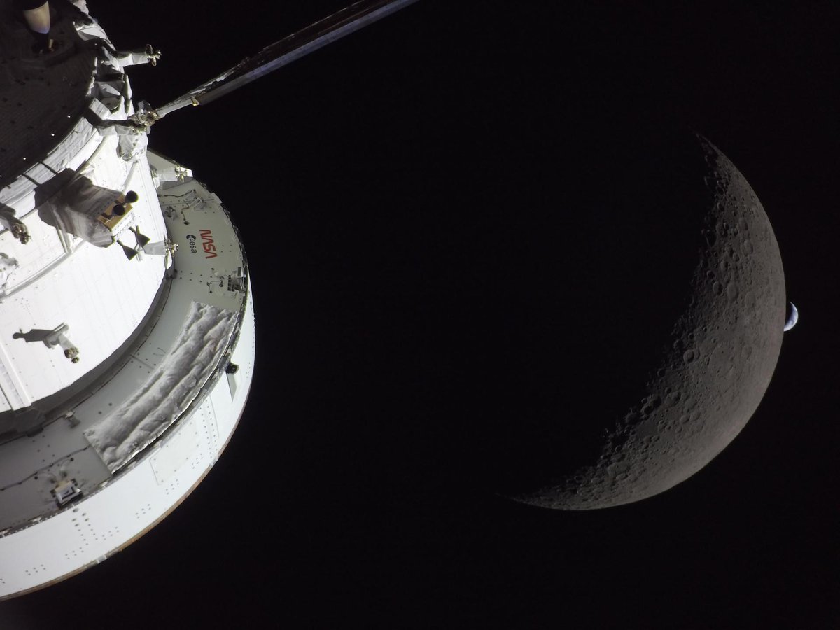
📷: NASA’s Orion spacecraft captures the Moon and the Earth in one frame during the Artemis II crew’s deep space journey at 6:42 p.m. ET on the sixth day of the mission.
USGS Earthquakes tweet media
English
19
474
2.6K
162.3K
USGS
USGS@USGS·
The Moon, revealed through its geology. 🌗 Explore the Unified Geologic Map of the Moon! Created by @usgs_astrogeo, in collaboration with @nasa and other partners, this first-ever comprehensive map reveals the Moon’s entire surface geology, combining Apollo-era data with recent satellite missions. It not only shows the 4.5-billion-year history of our lunar neighbor, but also serves as a key tool for future human missions and an invaluable resource for scientists, educators, and space enthusiasts. Download the full map and legend 👉ow.ly/yY7l50YAPCY 📹: This animation shows a rotating globe of the Unified Geologic Map of the Moon with shaded topography from the Lunar Orbiter Laser Altimeter (LOLA). Credit: NASA/GSFC/USGS. #NASA #Moon #GeologicMap
English
12
339
902
129.6K
USGS
USGS@USGS·
On the Iditarod Trail, winter conditions can change mile by mile. River ice thickens and thins. Snow bridges form and collapse. Glaciers shift. What looks solid one day may change the next. USGS scientists study glacier movement and ice conditions across Alaska to better understand how these winter landscapes behave. Because when travel depends on frozen rivers and valleys, reading the landscape matters. 📸 1: Aerial photo showing fracture line of avalanche along a snow ridge line. A reminder of how quickly conditions can shift in steep terrain. 📸 2: Steam rises through fractured ice at Redoubt Volcano, where heat from below reshapes the frozen surface above. 📸 3: View of Nellie Juan Glacier from Wolverine Glacier, where visibility and weather can change in minutes. Credit: USGS
USGS tweet mediaUSGS tweet mediaUSGS tweet media
English
4
4
37
7K
USGS
USGS@USGS·
Each March, mushers and sled dogs prepare to travel one of Alaska’s most historic winter routes during the Iditarod Trail Sled Dog Race. The trail itself isn’t permanent. It takes shape each winter. The depth, density, and timing of snowpack determine when a winter trail can safely take shape across public lands, including sections managed by the Bureau of Land Management. Small shifts in temperature can mean thinner snow at lower elevations or earlier melt in key sections. In fact, low snow has forced the Iditarod to move its starting location in 2003, 2015, 2017, and again in 2025. USGS scientists track snow conditions from satellites and in the field to better understand how Alaska’s winter landscape changes from year to year. By race day, winter has already built the trail across Alaska’s public lands. 📷: Landsat 9 image of Anchorage, Alaska, captured November 20, 2021. @BLMNational @BLMAlaska
USGS tweet media
English
1
5
42
7.5K
USGS
USGS@USGS·
Each year, reopening Going-to-the-Sun Road in Glacier National Park depends on daily avalanche forecasting and a decades-long partnership between the U.S. Geological Survey and the National Park Service.   The 50-mile engineering marvel crosses the Continental Divide, connecting the east and west sides of the park.   Since 2003, USGS avalanche scientists have worked side-by-side with the NPS to deliver daily avalanche forecasts that guide “go/no-go” decisions for crews clearing snow and avalanche debris from the road.   Spring conditions in Glacier can change quickly, with sudden snowstorms and avalanches threatening crew safety and slowing progress.   This USGS–NPS partnership ensures road crews have the information they need to work safely and efficiently, saving time and resources while helping the park prepare for the busy season ahead.   The Going-to-the-Sun Road typically opens in late June or early July each year. Visitors can check the park’s website for the latest updates.
English
1
6
56
7.4K
USGS retuiteado
USGS Volcanoes🌋
USGS Volcanoes🌋@USGSVolcanoes·
Hydrothermal explosions at Norris Geyser Basin...earthquakes...ground deformation...geyser eruptions... It's all in the latest Yellowstone Volcano Observatory monthly video update! youtu.be/aMNlRpbu5MI @YellowstoneNPS
YouTube video
YouTube
English
2
15
92
26.5K
USGS
USGS@USGS·
Happy 147th birthday to us! 🎉 We know, we know...we don’t look a day over 146 — but hey, that’s super young in geologic time! Mapping, measuring, and discovering since 1879. 🌎 #Freedom250 #America250
USGS tweet media
English
12
15
154
8.3K
USGS retuiteado
USGS Volcanoes🌋
USGS Volcanoes🌋@USGSVolcanoes·
Go back in time through decades of Kīlauea eruptions monitored by USGS scientists 🌋 ⚒️ 🪨 The USGS Hawaiian Volcano Observatory is the oldest volcano observatory in the United States. It was founded in 1912 and has been a part of several Federal Agencies—U.S. Weather Bureau (1919–1924), the U.S. Geological Survey (1924–1935), and the National Park Service (1935–1947)—before finding a permanent place with the U.S. Geological Survey in 1947. In the decades since then, scientists at the observatory have monitored dozens of eruptions at Kīlauea, which is one of the most active volcanoes on Earth. Kīlauea eruptions have reshaped Hawaii's landscapes time and time again. During the past 75 years, there have been 43 eruptions either at the summit or along the two rift zones. Discover where each of these eruptions occurred, how long they lasted, and what their impacts were with our new interactive timeline. 👉 Go here to learn more: usgs.gov/news/featured-… Photos of Kīlauea eruptions in 1960, 1973, 1983, 2009.
USGS Volcanoes🌋 tweet mediaUSGS Volcanoes🌋 tweet mediaUSGS Volcanoes🌋 tweet mediaUSGS Volcanoes🌋 tweet media
English
38
23
146
13.4K
USGS
USGS@USGS·
White Sands National Park - where geology meets history. Home to the world’s largest gypsum dunes and fossilized human footprints from ~23,000–21,000 years ago. Explore more sites like this on our Geoheritage Sites of the Nation Explorer 👉 ow.ly/b4Js50WCSM1
USGS tweet mediaUSGS tweet media
English
27
50
324
18.2K
USGS
USGS@USGS·
U.S. mines produced $112 billion in nonfuel mineral commodities in 2025—an estimated $6 billion increase from 2024, used in products valued at more than $4 trillion, or one-eighth of the US economy, according to the 2026 USGS Mineral Commodity Summaries released Feb 6 👉ow.ly/5MPR50YasgO #Mineral #CriticalMinerals
USGS tweet media
English
11
12
26
6.3K
USGS
USGS@USGS·
Regional view. Reliable data. Meet the USGS 250K OnDemand Topo. Big landscapes need big-picture maps. At 1:250,000 scale (1 inch ≈ 4 miles), it’s ideal for regional views—elevation, hydrography, boundaries, & more. Build your own custom 250K Topo👉 topobuilder.nationalmap.gov
USGS tweet mediaUSGS tweet media
English
6
6
29
6.5K
USGS retuiteado
USGS Volcanoes🌋
USGS Volcanoes🌋@USGSVolcanoes·
Yellowstone is famous for its literal ups and downs -- the ground there is constantly rising and falling. But how do scientists measure these moving mountains? Check the latest monthly video update of the Yellowstone Volcano Observatory to find out! youtu.be/MiCBA4jEGGE
YouTube video
YouTube
English
4
15
83
26.1K
USGS
USGS@USGS·
Maps from the 1800s. Unpublished photos of earthquakes and volcanoes. Decades of handwritten field notes. That’s just a glimpse of the USGS Library — one of the world’s most comprehensive Earth science libraries. Explore the collections 👉library.usgs.gov  #America250
USGS tweet mediaUSGS tweet mediaUSGS tweet media
English
7
27
146
10.1K
USGS
USGS@USGS·
Drawing the contours of a nation in the making. ✏️🗺️ In the late 1800s, topographers braved rugged terrain and harsh conditions to map the U.S.—long before aerial photos or GPS. Their work laid the foundation for America’s first detailed maps. History: pubs.usgs.gov/circ/1341 #America250 #TopographicMapping
USGS tweet mediaUSGS tweet mediaUSGS tweet mediaUSGS tweet media
English
4
7
38
8.3K
USGS
USGS@USGS·
Washington state experienced record-breaking flooding this past week. USGS streamgages measured the highest water levels on record on more than 10 rivers! 🚨 USGS water data helps emergency managers respond to rapidly changing conditions. 🦺 As the rain poured down, USGS crews made over 100 streamflow measurements along flooded riverways. 📈 From measuring how fast a river is flowing to the heights left by high-water marks, field observations and near real-time streamgage data inform emergency response. Explore current conditions data on the National Water Dashboard: dashboard.waterdata.usgs.gov #WashingtonState #WaterData #Flood
USGS tweet media
English
6
32
99
12.1K
USGS
USGS@USGS·
A M7.0 earthquake struck beneath the Hubbard Glacier in the St. Elias Mountains at 11:40 am AKST on December 6, 2025. Early remote-sensing results confirm hundreds of landslides and snow avalanches were triggered in the region. No injuries or fatalities have been reported due to the remote location. This GIF shows before-and-after radar images highlighting changes in surface roughness caused by the quake. The dots mark USGS’s preliminary mapping of potential landslides and avalanches. 🔴probable larger landslides 🟡probable smaller landslides/snow avalanches 🔵other increases in surface roughness of unknown origin Learn more here: #overview" target="_blank" rel="nofollow noopener">usgs.gov/programs/lands…
GIF
English
7
123
413
46.5K
USGS
USGS@USGS·
🎶 Baby, it’s cold inside… ❄️ The USGS operates the National Science Foundation Ice Core Facility in Denver, CO, storing Earth’s climate history at −36 °C. These frozen time capsules help scientists study past climates to help understand today’s changes. Science has never been cooler 🥶 ow.ly/TjCj50XJNY9
USGS tweet mediaUSGS tweet mediaUSGS tweet media
English
0
7
40
8.4K