🇺🇸DC🌸Storms 리트윗함
🇺🇸DC🌸Storms
9.7K posts


🇺🇸DC🌸Storms
@DCstorms
I forecast significant weather in DC & the Mid-Atlantic. GMU and PSU alumnus, Cat dad and Photographer. Instagram: dc_storms
Washington, DC 가입일 Mayıs 2021
721 팔로잉1.3K 팔로워
🇺🇸DC🌸Storms 리트윗함

Going back to October 2025, Baltimore had 5 consecutive months in a row with below Normal average temps for the first time in over 20 years! March 2026 will likely break the streak. It is going to get chilly this weekend, but we have had a lot of warm days (and severe weather) this month! Warmest temps on the 10th/11th. 85 both days.
English
🇺🇸DC🌸Storms 리트윗함
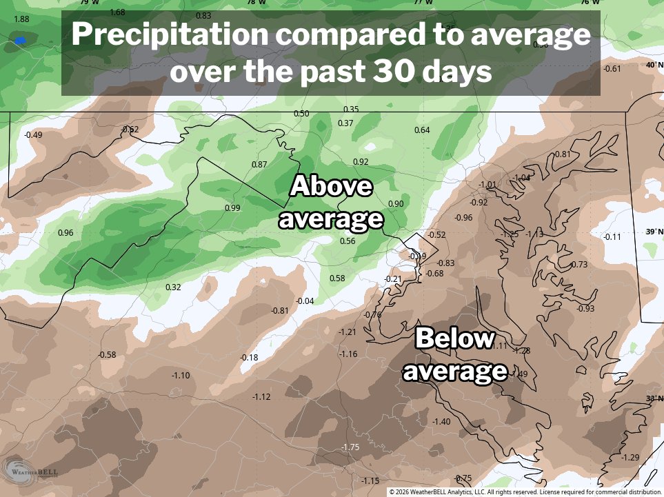
D.C. rainfall somewhat below average for the month
After some more rain Friday into Saturday, and again this morning, D.C. is up to 1.79 inches of precipitation (melted snow plus rain) on the month. That’s a little below average to date — the story is a bit different to the west of Interstate 95.
Overall, the highway is a good boundary between somewhat above average precipitation west and below average east. Some of this is thanks to last Monday’s storm system focusing the most persistent thunderstorm activity to the west of Interstate 95 in our area.
Dulles International Airport is at 2.61 inches, or roughly 3/4 of an inch above average to date.
The map here does a pretty good job of highlighting the haves and have nots locally. It’s over the past 30 days, so it runs into the final week of February.
English
🇺🇸DC🌸Storms 리트윗함
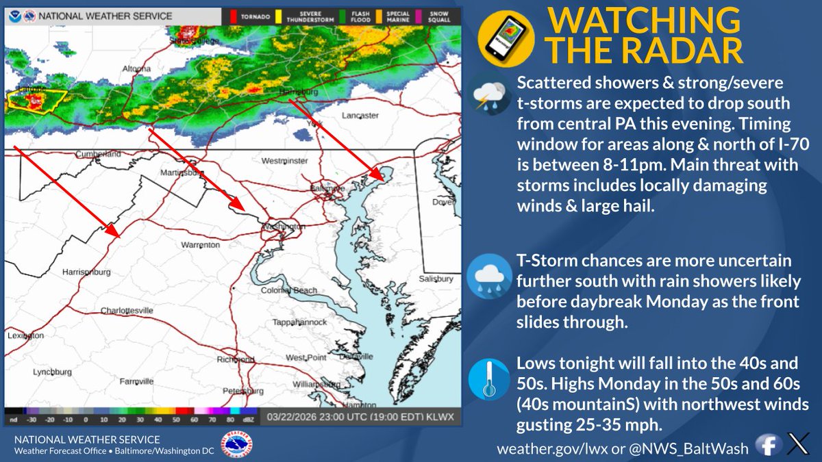
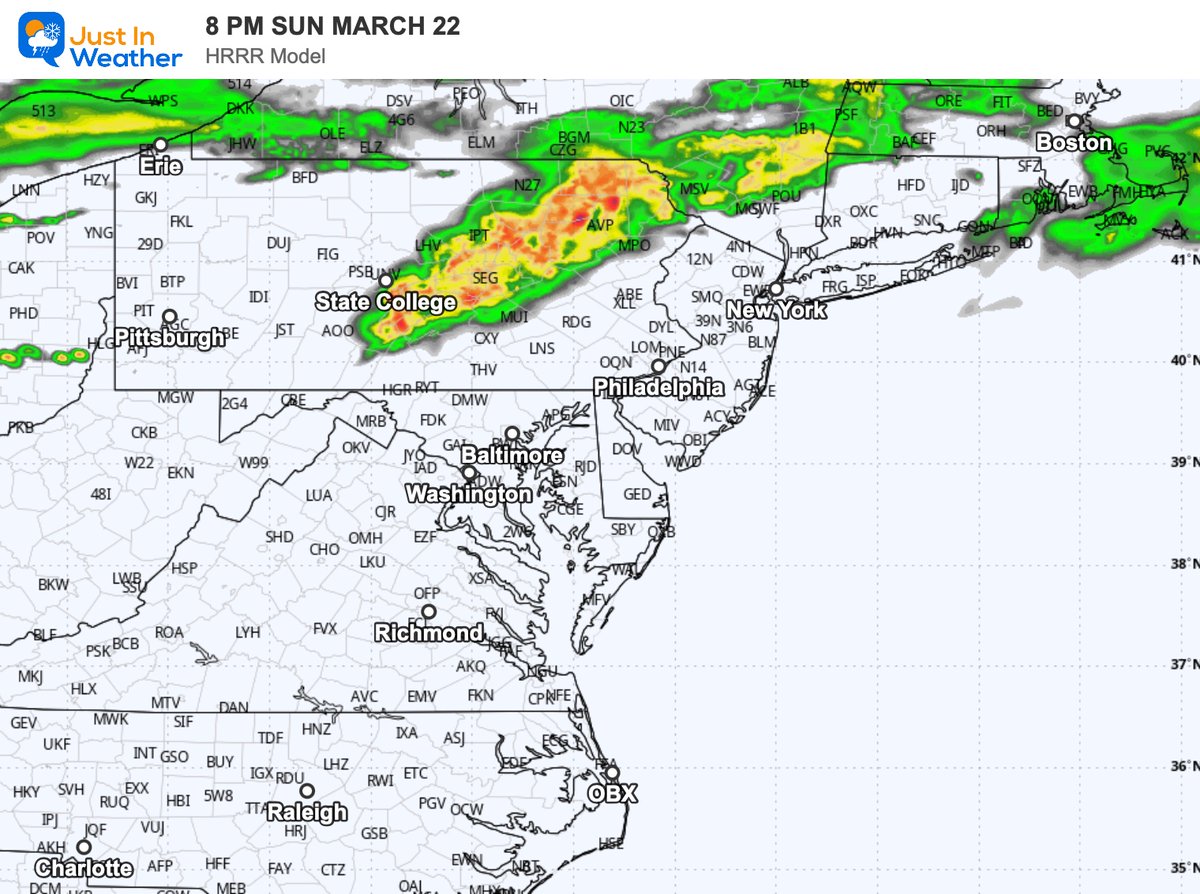
7:23PM-A broken line of showers & t-storms drops south from PA this eve.. This activity continues to fight a capped atmosphere mired by dry air at the surface. If storms hold together expect locally damaging winds & isolated large hail. More uncertainty as the front pushes south.
English
🇺🇸DC🌸Storms 리트윗함

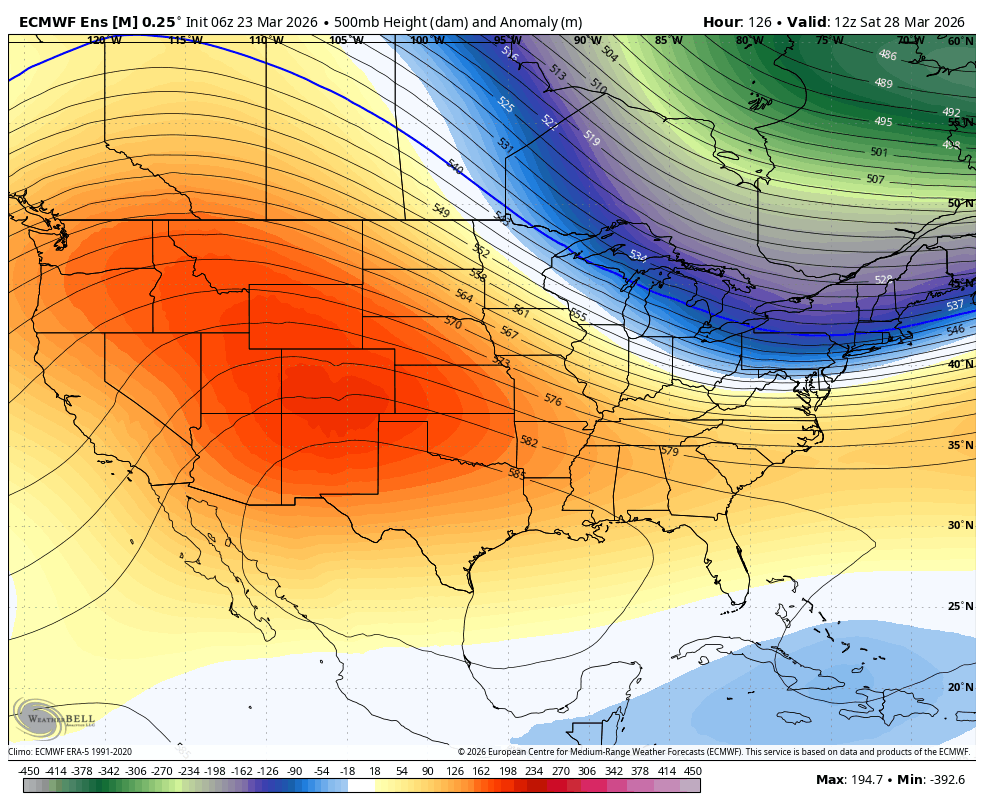
Another #PolarVortex split/SSW this week. Our best in competition AI model says increased chances of hi latitude North Atlantic blocking early April that consolidates over Greenland by mid-April. Who isn't excited for extended cool, damp spring weather on both sides of the pond?


English
🇺🇸DC🌸Storms 리트윗함


🇺🇸DC🌸Storms 리트윗함

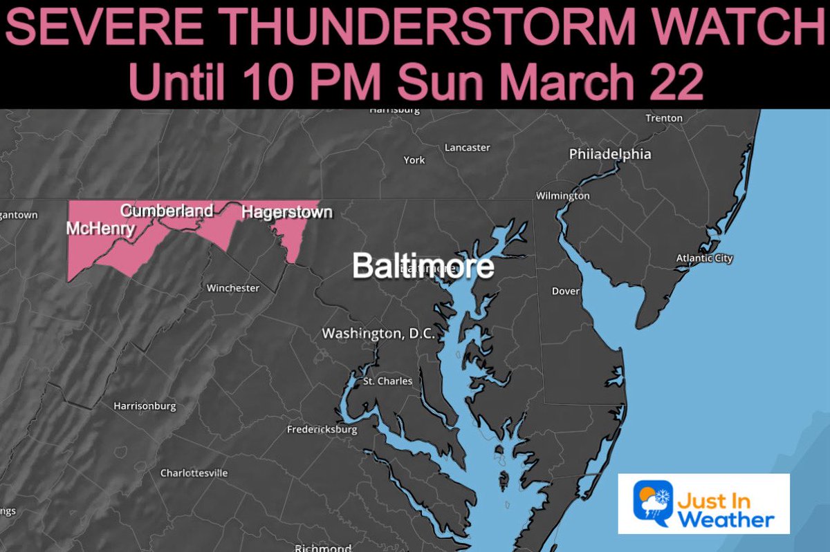
⚠️ ⛈️ SEVERE THUNDERSTORM WATCH
⏰ Until 10 PM Sun Mar 22
📍 Western Maryland: Garrett, Allegany, Washington Counties.
👉🏻 This means POTENTIAL for storms to reach severe limits. It is not a promise, until - IF a Warning is issued.
🧊 Potential for Large Hail 1” to 2” Diameter
💨 Wind Gusts to 60 mph.
👍🏻 This was expected with the Storm Outlook.
English
🇺🇸DC🌸Storms 리트윗함

It's been the warmest start to March on record across the United States, in terms of high temperatures, with an average of 60 degrees.
That's *7.6 degrees* above-average for March, month-to-date!
March 2026 is tracking to become one of the most anomalously warm months on record for the country.
Here's a list of statewide temperatures compared to average:
California: +9.5˚F
Arizona: +9.1˚F
Nevada: +9.0˚F
Kentucky: +8.9˚F
West Virginia: +8.6˚F
Tennessee: +8.6˚F
Arkansas: +8.5˚F
Ohio: +8.3˚F
New Mexico: +7.7˚F
Oklahoma: +7.6˚F
Texas: +7.5˚F
Indiana: +7.5˚F
Colorado: +7.4˚F
Wyoming: +7.2˚F
Mississippi: +7.2˚F
Utah: +7.2˚F
North Carolina: +7.0˚F
Missouri: +6.8˚F
Virginia: +6.8˚F
Pennsylvania: +6.7˚F
Illinois: +6.4˚F
Nebraska: +6.0˚F
Oregon: +5.9˚F
Alabama: +5.9˚F
Idaho: +5.9˚F
Kansas: +5.9˚F
South Carolina: +5.8˚F
Louisiana: +5.7˚F
Georgia: +5.5˚F
South Dakota: +5.5˚F
Montana: +5.5˚F
District of Columbia: +5.3˚F
New York: +5.0˚F
Iowa: +4.9˚F
Vermont: +4.9˚F
Maine: +4.8˚F
Delaware: +4.6˚F
Maryland: +4.6˚F
New Hampshire: +4.6˚F
Florida: +4.4˚F
New Jersey: +3.8˚F
Michigan: +3.7˚F
Wisconsin: +3.7˚F
Connecticut: +3.3˚F
Massachusetts: +3.3˚F
Washington: +3.2˚F
North Dakota: +2.8˚F
Minnesota: +2.3˚F
Rhode Island: +1.9˚F

English
🇺🇸DC🌸Storms 리트윗함
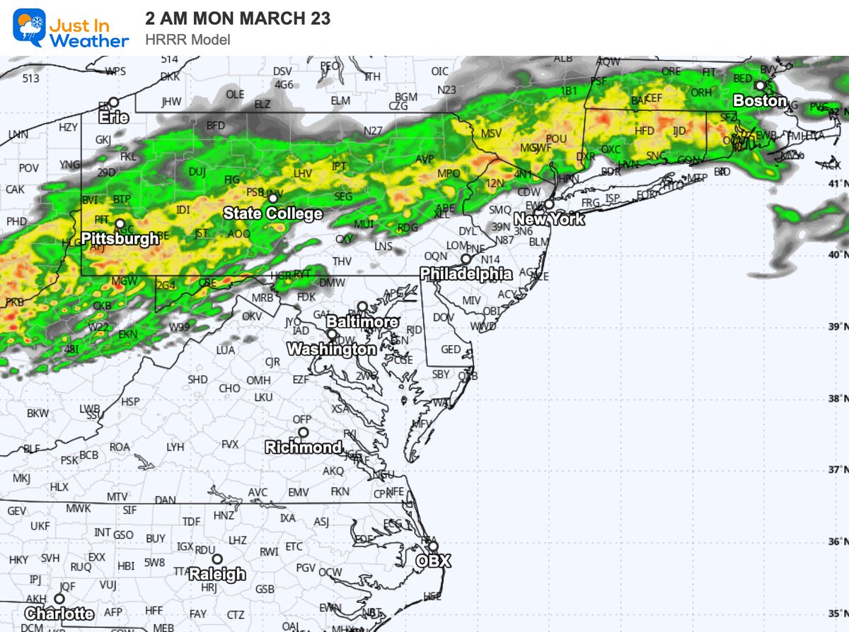
A strong cold front will move through the area this evening into tonight. Showers and thunderstorms are expected along the front. Some of the storms could be severe especially near the PA/MD state line. Large hail and damaging winds are the main threats.


English
🇺🇸DC🌸Storms 리트윗함
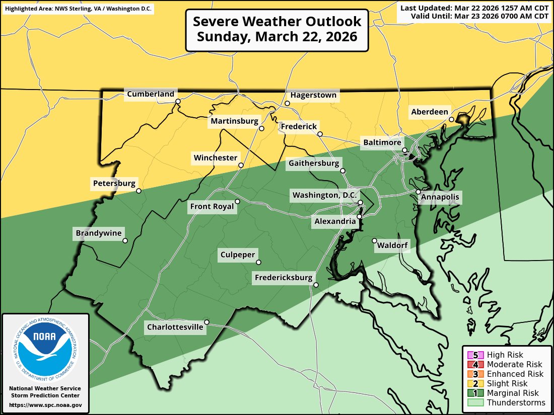
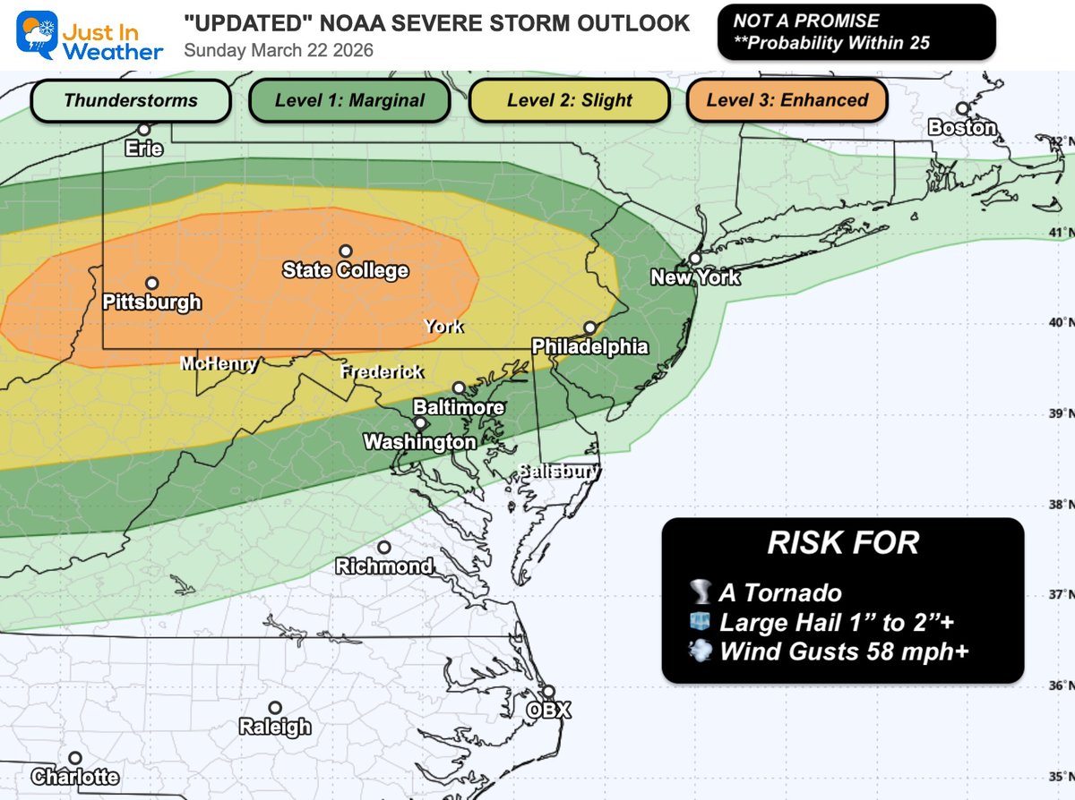
Sunday Afternoon Update
⚠️⛈️ NOAA UPDATED the Severe Storm Risk and INCREASED the threat for Central and Western PA.
⏰ 6 to 8 PM "THERE"....
🧊 Hail may reach over 2"
👀 While there is Slight Risk into Central Maryland, I do NOT see it reaching here until TONIGHT.
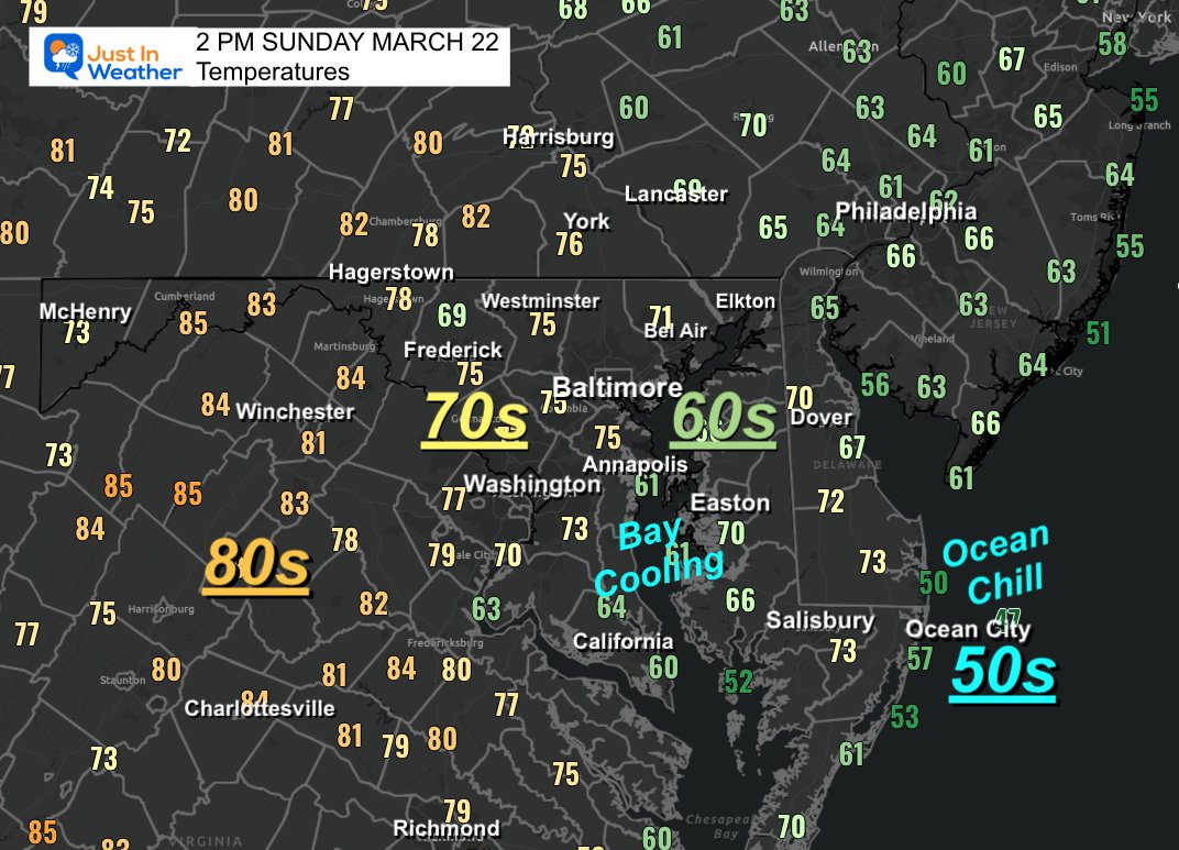
🌡️ Temps at 2 PM Sun Mar 22
🥵 80s INLAND
🥶 50s By The Beach
🌊 Chilly 60s along the Chesapeake Bay...
How is it by you???
ENJOY THE DAY!
English
🇺🇸DC🌸Storms 리트윗함

SUNDAY, March 22 could feature some hailstorms along the Ohio River and in southwestern/south central Pennsylvania. The Storm Prediction Center is now cautioning that a few rotating supercells with large hail potential are expected to form. IF a supercell can become established, it could produce large hail up to about hen egg-sized... roughly 2 inches across.
Rotating storms are the most efficient at producing hail, and these will be rotating storms. Why a minimal tornado threat? Scant low-level moisture. It will be dry near the surface. If we pump more moisture north than originally expected, then a tornado threat could materialize. That's TBD.

English
🇺🇸DC🌸Storms 리트윗함

🇺🇸DC🌸Storms 리트윗함
Temps will continue to modify Fri thru the weekend. Highs Fri in the 60s to 70. Temp low to mid 70s more common Sat with cooler numbers in Northeast MD and along the Chesapeake Bay. Front brings showers Fri night. A stronger front Sun ngt into early Mon. More showers then.

English
🇺🇸DC🌸Storms 리트윗함
🌵 Drought Monitor Update
💦 IMPROVED - But We Still Need More
👀 Here's the latest look By Popular Request:
Data released today March 19, completed March 17 (it takes two days)
⚖️ Regional Breakdown
🔻 Baltimore (BWI): Dry short-term and long-term deficit
🔻 National (DCA): Slightly dry, especially in March
🔺 Dulles (IAD): Slight surplus
✈️ Closer Look at the Big Three Airports
📍 Baltimore (BWI)
📅 March to Date
Observed: 1.87”
Normal: 2.34”
Departure: 🔻 -0.47”
📆 Year to Date
Observed: 6.47”
Normal: 8.32”
Departure: 🔻 -1.85”
📉⚠️ Long-Term Context
2024 + 2025 Combined: 🔻 -16.91” deficit
👉 Big Picture:
A deep multi-year deficit continues, with 2026 still running below normal.
📍 Washington National (DCA)
📅 March to Date
Observed: 1.49”
Normal: 2.00”
Departure: 🔻 -0.51”
📆 Year to Date
Observed: 7.22”
Normal: 7.48”
Departure: 🔻 -0.26”
👉 Big Picture:
Near normal overall, but March has trended drier, contributing to a slight yearly deficit.
📍 Washington Dulles (IAD)
📅 March to Date
Observed: 2.21”
Normal: 1.99”
Departure: 🔺 +0.22”
📆 Year to Date
Observed: 8.01”
Normal: 7.54”
Departure: 🔺 +0.47”

English
🇺🇸DC🌸Storms 리트윗함


🇺🇸DC🌸Storms 리트윗함
🇺🇸DC🌸Storms 리트윗함
🇺🇸DC🌸Storms 리트윗함

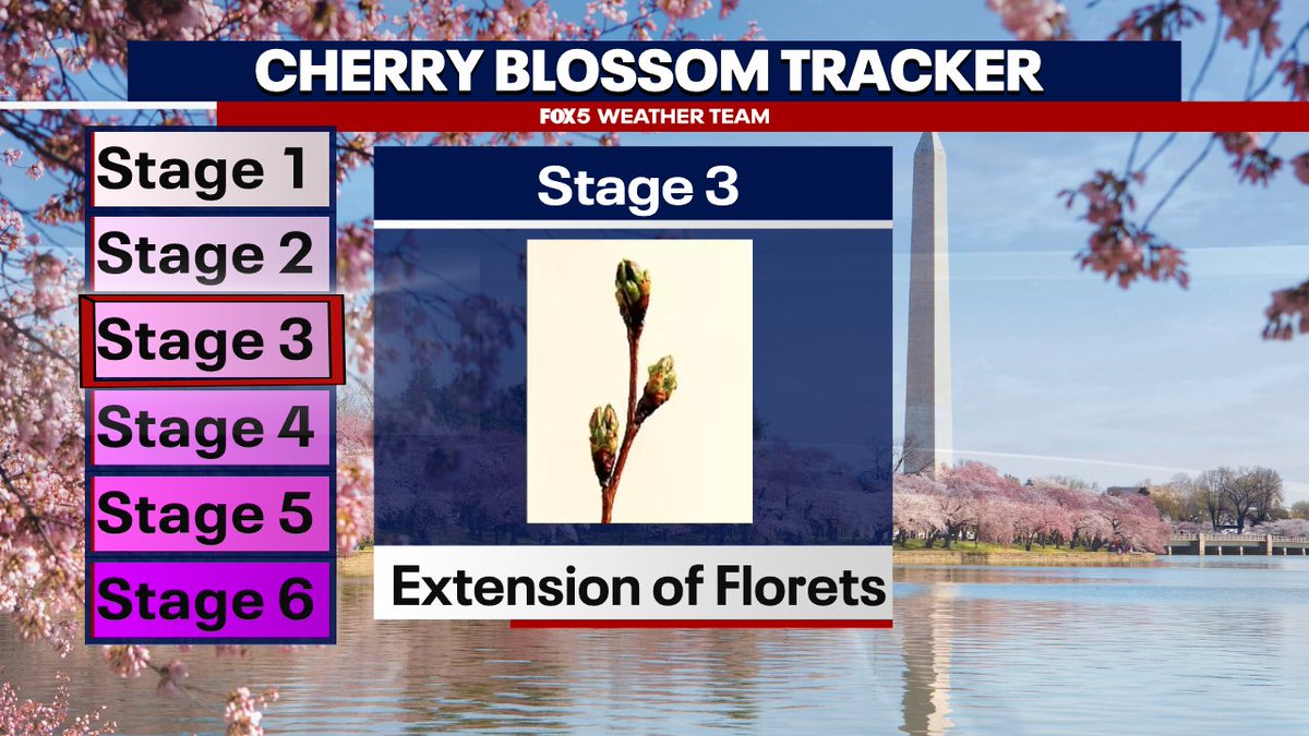
The trees are halfway there! A warm weekend ahead will likely help them get to stage 4!
English
🇺🇸DC🌸Storms 리트윗함
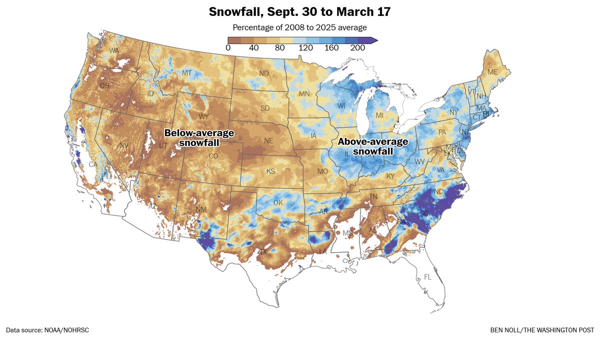
Here's the almost-final seasonal snow anomaly map.
While just 23 percent of land area had above-average snow, 35 percent of the total population had above-average snow, highest since 2020-21.
The western snow drought was huge — parts of Florida had more snow than parts of Utah.
English
🇺🇸DC🌸Storms 리트윗함
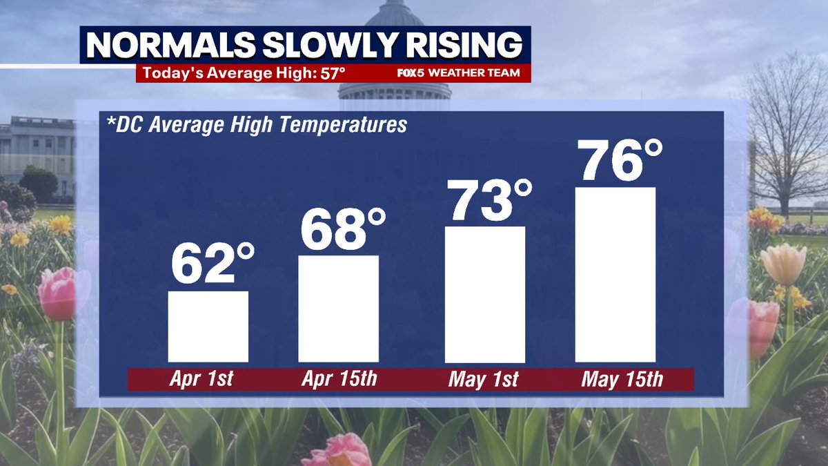
We are at that time of year where the extra daylight starts impacting temperatures pretty fast. Average highs come up about 20°F over the next two months here in DC! Spring is almost here...
English