#30DayMapChallenge Day 30: Makeover... of the 1958-1974 2LUSB field maps into digital residential footprints, more useable in the digital age. A flavour of what can be done with machine learning to extract residential footprints for ONS’s Historical Censuses Digitisation Project!
#30DayMapChallenge Day 29: Raster. A map of the Lake District with the Ordnance Survey MiniScale raster, the National Park Boundary and ONS Output Area population weighted centroids available to download on the Open Geography Portal
#GIS#Mapping#geospatial
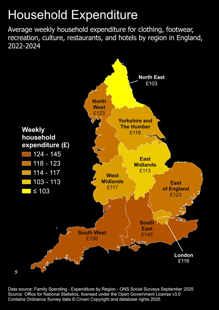
#30DayMapChallenge Day 28: Black Friday. Average weekly household expenditure for clothing, footwear, recreation, culture, hotels, and restaurants by region in England for financial year ending 2022 to financial year ending 2024 (3-year average). Data: ons.gov.uk/peoplepopulati…
#30DayMapChallenge Day 27: Boundaries. A map comparing the modern Welsh-English border with the historic boundary of Offa’s Dyke (now the route of a hugely popular hiking path). Check out the ONS Open Geography Portal to access boundary products and more geoportal.statistics.gov.uk
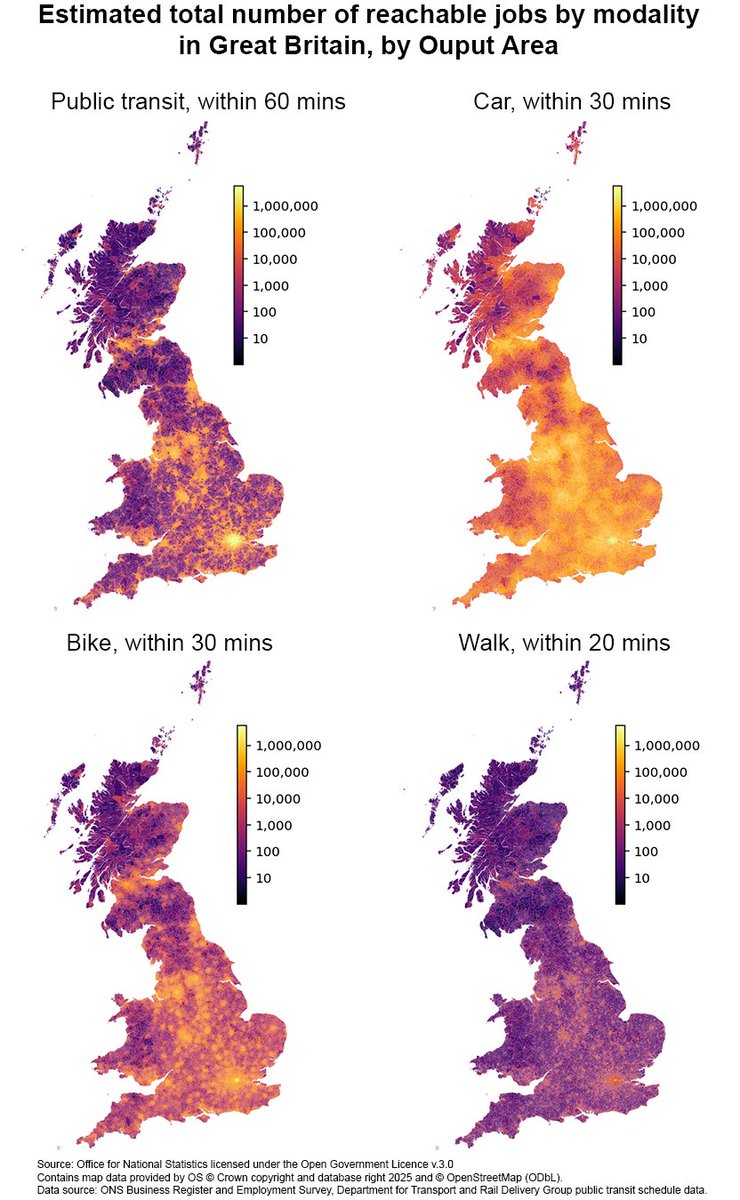
#30DayMapChallenge Day 26: Transport. Estimated reachable number of jobs across GB by modality 🚌🚗🚴🚶Built by combining ONS Business Register and Employment Survey data with travel time estimates at Output Area level. Watch ONS Local Presents here: vimeo.com/user99857619/r…
#30DayMapChallenge Day 25. Hexagons. A hexagonal map of Middle-Super Output Areas (MSOAs) in England and Wales, showing Census 2021 population estimates of residents living in households or communal establishments.
#30DayMapChallenge Day 23: Process. Which map would you choose? The ONS 'Geography and Statistics Training' provides guidance on the map-making process, as well as QGIS training and geospatial-specific courses for Python and R ➡️
onsgeo.github.io/geospatial-tra…
#30DayMapChallenge Day 1: Icons. Highest concentrations of parks and pubs are found in central London, reflecting the diverse recreational opportunities in the heart of the city. Explore the data for 'Access to local amenities in England and Wales 2024': ons.gov.uk/peoplepopulati…
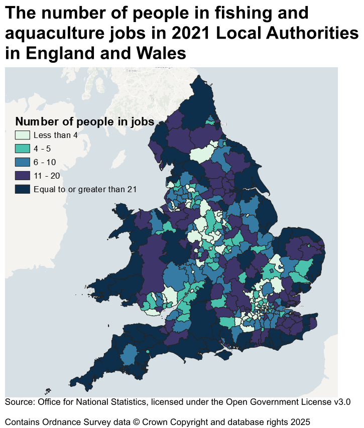
#30DayMapChallenge Day 20: Water. This map shows the number of usual residents in England and Wales employed in fishing and aquaculture by Local Authority District. Data is from the 2021 Census #get-data" target="_blank" rel="nofollow noopener">ons.gov.uk/datasets/creat…
#GIS#mapping#geospatial
#30DayMapChallenge Day 17: A New Tool. Experiment 3D rendering with Aerialod. Population density from ONS 2024 Population Estimates and Census 2021 Lower Super Output Areas; normalised to area, then rasterised to 1km grid.
#GIS#Mapping#geospatial
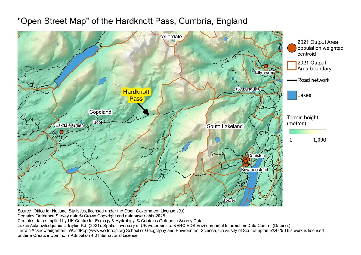
#30DayMapChallenge Day 14: OpenStreetMap. We ❤️OSM but here's our fun take on 'open streets'...
An “open street map” in England. OS Open Roads data show the remote (open) road. Population weighted centroids emphasises the “openness” of the areas these roads pass through 🛣️
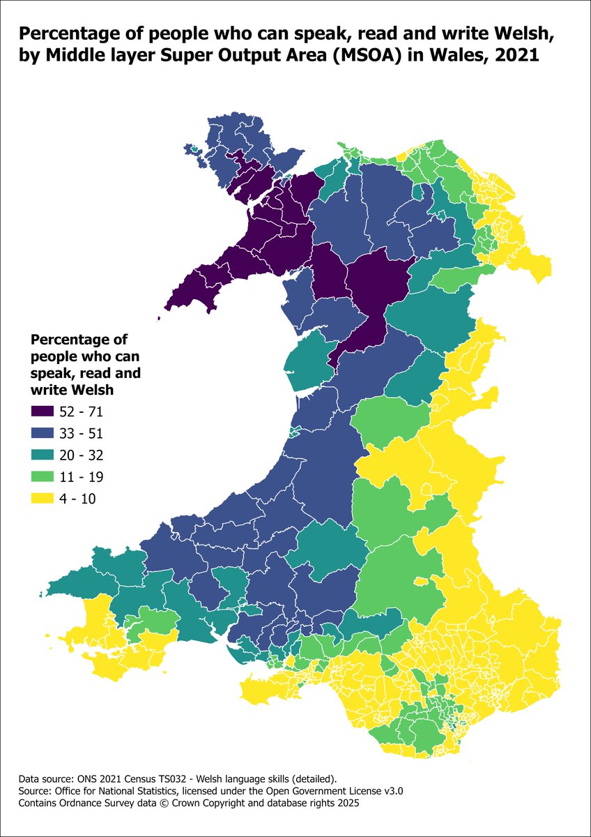
#30DayMapChallenge Day 13: 10-minute map⏳Once the data was downloaded, we set the timer and made this map of people who speak, read, and write Welsh. The data is from Census 2021 downloaded from the Nomis website (TS032 - Welsh language skills)
nomisweb.co.uk/sources/census…
#30DayMapChallenge Day 12: Map from 2125 🔍🔮 What will the UK population be in the next 100 years? This time-series map uses 2022-based national population projections to show annual population change estimates up to the year 2122. Publication and data: ons.gov.uk/peoplepopulati…
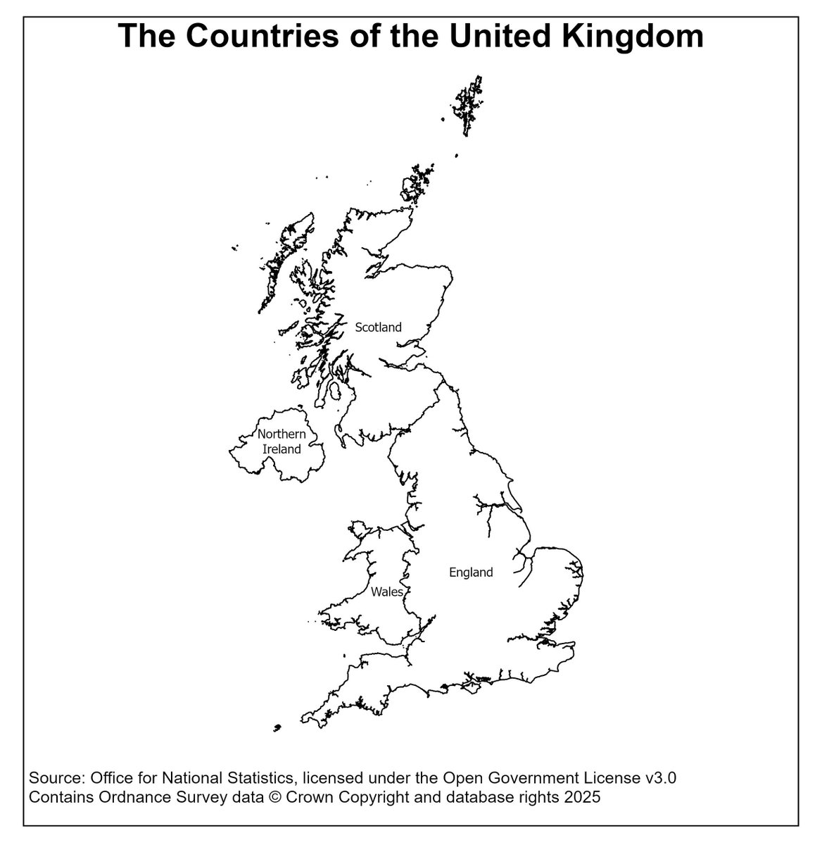
#30DayMapChallenge Day 11: Minimal. Scotland, Northern Ireland, Wales, and England — the countries of the UK. Source: Office for National Statistics (ONS) Open Geography Portal, December 2024 UK generalised clipped boundaries (BGC). Download here: geoportal.statistics.gov.uk#GIS
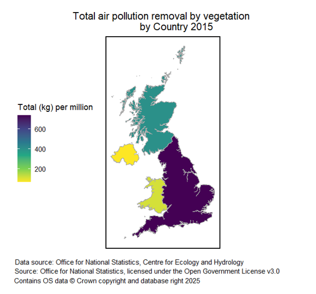
#30DayMapChallenge Day 10: Air. This map shows the amount of air pollution removal in each Country of the UK in 2015. Air pollutants were removed by woodlands, plants, grasslands and other vegetation. Read more in this article: ons.gov.uk/economy/enviro…#GIS#mapping#geospatial