Argantonio Tartessos

4.9K posts

Argantonio Tartessos banner
Argantonio Tartessos

Argantonio Tartessos

@ArgantonioTart2

La #Agenda2030 es una agenda oscura que pretende adaptar a la sociedad al nuevo Gran Mínimo Solar… (Lamentablemente Twitter sigue capando cuentas).

Katılım Kasım 2022
299 Takip Edilen668 Takipçiler
Sabitlenmiş Tweet
Argantonio Tartessos
Argantonio Tartessos@ArgantonioTart2·
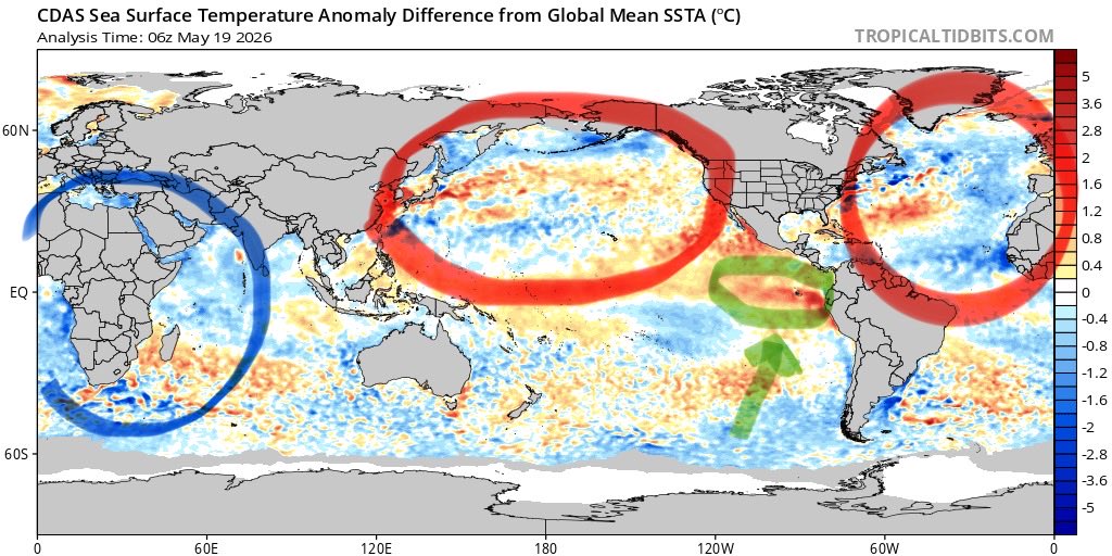
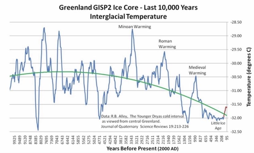
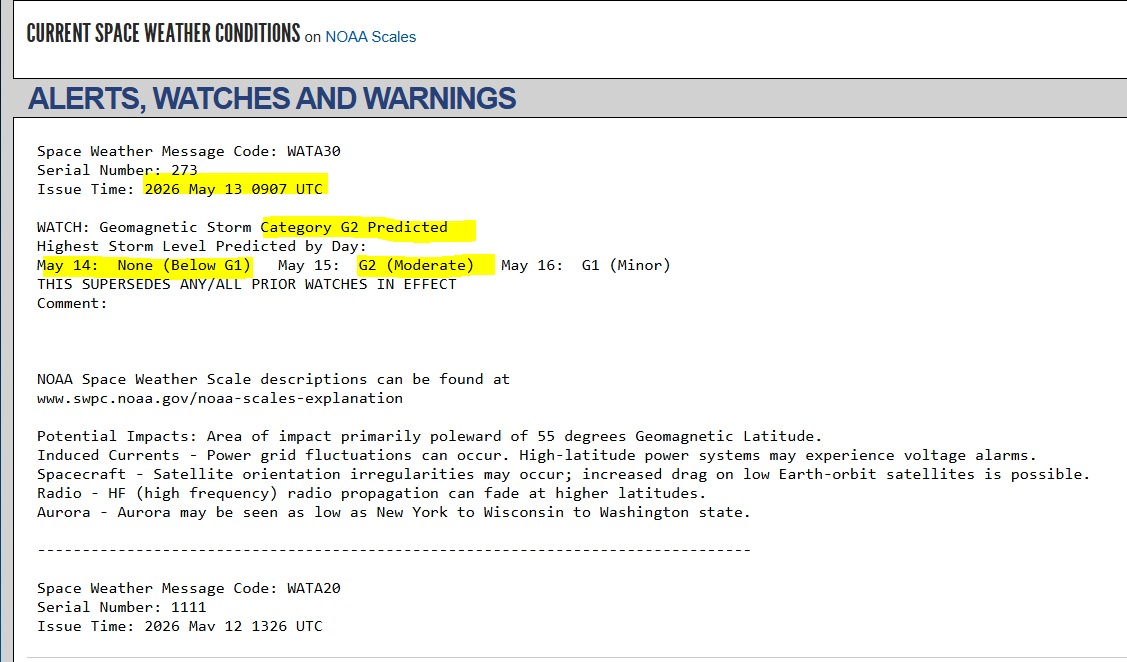
La posición relativa de los planetas con respecto al sol, marcan su actividad. 2024 es el inicio de un período oscuro en el que sólo los más preparados sobrevivirán al evento. El baricentro caótico marcará nuestro futuro inmediato. Hambrunas y caos. #CalentamientoGlobal?
Argantonio Tartessos tweet media
Español
4
5
21
17.3K
Argantonio Tartessos retweetledi
Sebastian Tyszuk
Ciepła podmorska fala Kelvina przesuwa się na wschód, jednak widać, że nie posiada kontynuacji, za nią postępuje zimna anomalia wody, która już zaczyna chłodzić wody powierzchniowe w obszarze Nino 4 oraz Nino 3.4. To słabo wróży pojawieniu się EL Nino.
Polski
1
2
10
3K
Argantonio Tartessos
Argantonio Tartessos@ArgantonioTart2·
Un nuevo ciclo astronómico está modificando el Clima, y entornos como el Creciente Fértil vuelven a la vida. La producción primaria de los otrora desiertos aumenta hasta el punto de que muchas hortalizas producidas en el Sahel ya inundan los mercados de Europa.
Argantonio Tartessos tweet media
𝓃𝒶𝒿𝒹@mmkotibi

البل شعاها نفيضه وسرحت يمه 👈 من أجمل المناظر الي ممكن تشاهدها بخار البرد 🌫️❄️😍

Español
3
3
21
8K
Hodhodata@statistics
Hodhodata@statistics@Statisticizer·
🕯️🫰👌
Hodhodata@statistics@Statisticizer

Roberto, I understand your point, and yes , at this moment the ensembles still largely support ridge dominance over western Europe. Nobody is denying the current consensus. My post is so clear, GFS and ECWMF do Not support my outlook ( Now ) except the Canadian model . But atmospheric evolution is not static. These models are continuously updated every few hours as new observational data are assimilated, and transitional spring regimes are especially sensitive to Rossby-wave amplification, jet displacement, and trough undercutting. A “zero indication” today does not mathematically guarantee a zero indication 48 hours later. We have seen countless situations where small embedded disturbances within a ridge later evolved into much larger western Mediterranean troughs or cut-off lows after only a few model cycles. I am not saying the #DANA scenario is currently the most likely outcome , only that the broader synoptic background leaves the door open for such evolution, particularly given the present North Atlantic–Caspian contrast pattern. Forecasting is about monitoring tendencies, probabilities, and dynamical evolution ,not freezing a single ensemble snapshot as permanent reality. And simply that is what you've done here, Habibi! Also, it is important to distinguish between probabilistic ensemble guidance and deterministic operational forecasts. They are related tools, but they are not the same “face of the same coin,” and each serves a different forecasting purpose.

Hashemite Kingdom of Jordan 🇯🇴 ART
1
0
0
839
Hodhodata@statistics
Hodhodata@statistics@Statisticizer·
Roberto, I understand your point, and yes , at this moment the ensembles still largely support ridge dominance over western Europe. Nobody is denying the current consensus. My post is so clear, GFS and ECWMF do Not support my outlook ( Now ) except the Canadian model . But atmospheric evolution is not static. These models are continuously updated every few hours as new observational data are assimilated, and transitional spring regimes are especially sensitive to Rossby-wave amplification, jet displacement, and trough undercutting. A “zero indication” today does not mathematically guarantee a zero indication 48 hours later. We have seen countless situations where small embedded disturbances within a ridge later evolved into much larger western Mediterranean troughs or cut-off lows after only a few model cycles. I am not saying the #DANA scenario is currently the most likely outcome , only that the broader synoptic background leaves the door open for such evolution, particularly given the present North Atlantic–Caspian contrast pattern. Forecasting is about monitoring tendencies, probabilities, and dynamical evolution ,not freezing a single ensemble snapshot as permanent reality. And simply that is what you've done here, Habibi! Also, it is important to distinguish between probabilistic ensemble guidance and deterministic operational forecasts. They are related tools, but they are not the same “face of the same coin,” and each serves a different forecasting purpose.
Hashemite Kingdom of Jordan 🇯🇴 English
3
4
11
1.8K
Roberto Granda
Roberto Granda@EnMet3·
0 indicios en los modelos físicos, la herramienta más fiable que tenemos, de cambio a lo que aquí dicen. El final de mes, con un consenso elevado, se presenta dominado por la dorsal en Europa occidental. La DANA señalada es un sistema embebido en la dorsal, nada más.
Roberto Granda tweet mediaRoberto Granda tweet media
Hodhodata@statistics@Statisticizer

#HeadsUp 🌡️➡️⛈️ Despite the strong heatwave signal currently projected by operational models over parts of central and western Europe, the broader synoptic pattern may become increasingly unstable later in May, with potentially rapid adjustments in upcoming model runs. The current ridge over western Europe ( Barents Sea ) , counteracted by lower geopotential heights near the North Caspian and Ural sector, may eventually favor Rossby-wave amplification and trough detachment toward southwestern Europe and the western Mediterranean — as illustrated by the black arrow. Colder, denser air masses can undercut and displace warm ridging patterns across western Europe, especially under amplified spring flow regimes. This might happen at the same time with formation of Cyprus Low in East Mediterranean sea ( which had materialized yet) . This setup resembles a classical positive North Sea–Caspian dipole (+NCP)-type configuration, a transitional-season pattern that tends to recur more frequently during spring and autumn. If this evolution verifies, cut-off low / #DANA development near Iberia or the Balearic region cannot be ruled out, increasing the likelihood of storminess across inland and northeastern Spain during the final decade of May. The attached 20-analog spring composite also supports the possibility of a colder upper trough/basin forming over the western Mediterranean. At this stage, GFS and ECMWF do not fully support this scenario yet, but the currently projected persistent heat dome may become less stable in subsequent runs. In simpler terms: I broadly agree with Javier ( @Canalcienciaym ) that a transient Rossby-wave amplification during spring should not automatically be interpreted as a long-duration or extreme heatwave regime. Heat waves occur when latent heat builds up over several days while exceeding the high percentile of the period expected temperatures , holding heat into concrete building that radiates heat back at us day and night and persistently for extended period exceeding 4 consecutive days , this pattern is however dynamic and Fastly changing. Indeed the digital models supports this possible scenario at the meantime, a Cyprus Low is expected and it had formed but no Balearic sea Low had formed yet, next few days runs in those models can be very important.

Español
3
3
60
17.2K
Antonio K Johnson
Antonio K Johnson@AntonioKJohnso1·
@ArgantonioTart2 Sounds to me the media pushing this agenda of trying engineering geo weather engineering of havoc of their own making there. And we just had strong nino 2 years ago 2023-2024 and now 2 years later another strong or worst super nino is unusual there.
English
1
0
7
2.8K
Argantonio Tartessos
Argantonio Tartessos@ArgantonioTart2·
Los Medios informando sobre el supuesto “Súper El Niño”, esa pequeña mancha verde, errática, y de corta duración, pero no hablan de lo que supone que tanto el Atlántico como el Pacífico Norte entren en su fase Multidecadal fría con un Sol en proceso de hibernación…
Argantonio Tartessos tweet media
Español
22
55
318
43.1K
Lapacho
Lapacho@Lapacho57876443·
@ArgantonioTart2 Las aguas superficial y profunda al sur del pacífico están frías, empujando hacia arriba en dirección del Niño 2 y 3.4, veremos que mes llegan a neutralizar a las aguas del Enso.
Español
2
0
5
2.4K
Argantonio Tartessos
Argantonio Tartessos@ArgantonioTart2·
El Lago Chad iba a desaparecer según los expertos debido al “Calentamiento Global”, pero la realidad es que el lago no para de crecer y ya inunda los bosques de sus antiguas orillas mientras N’Djamena construye infraestructuras de drenaje para contener las inundaciones…
Argantonio Tartessos tweet media
PNUD TCHAD@PNUD_Tchad

Mieux protéger contre les inondations 🇹🇩 En 2025, nous avons soutenu des infrastructures de drainage et de gestion des déchets à N’Djamena pour réduire les risques d’inondation et protéger les communautés et les écoles les plus exposées. #RésilienceUrbaine #ActionClimat

Español
0
1
10
584
Argantonio Tartessos
Argantonio Tartessos@ArgantonioTart2·
Abundan las teorías sobre la manipulación climática para provocar lluvias a voluntad ante la irrupción de las lluvias en Oriente Medio, y es de suponer que en el anterior periodo húmedo en el que se formó el Creciente Fértil, ya disponían de tal tecnología… 😜
Argantonio Tartessos tweet mediaArgantonio Tartessos tweet media
Yaseer G@g_yaseer69235

Mosul Dam opens its gates that have been closed for a long time After Iran destroyed the systems and equipment of the American #HAARP project in the UAE The lean years that altered the climate of Iraq and the region have come to an end.........

Español
0
2
9
505
Argantonio Tartessos
Argantonio Tartessos@ArgantonioTart2·
Un precioso ejemplar de colirrojo real en la Sierra de #Aracena (#Huelva), concretamente en el bello paraje del Talenque, entre robles, quejigos, peonías, digitalis, y algunos pinsapos, tilos y avellanos… Una de las más bellas aves estivales de #Europa.
Argantonio Tartessos tweet media
Español
1
1
10
225
Argantonio Tartessos
Argantonio Tartessos@ArgantonioTart2·
#Huelva: La Sierra de Aracena en plena brotación primaveral. Alcornoques, robles, quejigos, avellanos, saúcos, alisos, castaños, cerezos, y un sinfín de plantas maravillosas, colaboran para crear una auténtica selva ibérica en un gigantesco bosque de ensueño…
Argantonio Tartessos tweet media
Español
0
6
25
692
Hodhodata@statistics
Hodhodata@statistics@Statisticizer·
@grok Tracking this forecast for validity, how would you rate the forecast relative accuracy thus by far?
Hashemite Kingdom of Jordan 🇯🇴 English
2
0
4
519
Hodhodata@statistics
Hodhodata@statistics@Statisticizer·
👍 Nearly right on time! The NOAA Space Weather Prediction Center (SWPC) has now issued a G2 geomagnetic storm watch almost exactly within the time window highlighted by my statistical geomagnetic activity forecast model ( between 14-16 May) . So far, this experimental AI/statistical forecasting approach has successfully identified two geomagnetic uptick periods: • The 5–7 May interval • The 13–14 May interval and remarkably the AI based forecast puts the activity this week as a mild positive geomatic activity and not so intense, congruent with NOAA G2 storm speculative . I am now closely monitoring the remainder of the second half of May to evaluate how this prototype forecasting framework performs. If the current statistical signal continues to verify, the period between approximately 18th-24th of May we may observe another heightened Geomagnetic solar activity but around 25–30 May could potentially feature an unusually strong geomagnetic activity episode given the space climatology of this period of the year and solar cycle . The forecast remains probabilistic and experimental rather than deterministic, and ongoing verification is essential. Nevertheless, it is encouraging to see early temporal agreement between the statistical analog-based projections and operational monitoring by NOAA SWPC. 👉NOAA SWPC alert report: swpc.noaa.gov/products/alert… Original Forecast Post by @Statisticizer is attached as a repost.
Hodhodata@statistics tweet mediaHodhodata@statistics tweet media
Hodhodata@statistics@Statisticizer

☀️🛰️ Solar Geomagnetic Storm Predictions for May: Periods of intensified solar flare and geomagnetic activity may develop during several time windows throughout May, as illustrated in the Geomagnetic Storm Index anomaly chart. The positive red 🔺deflections in the chart indicate potential incoming geomagnetic storm episodes (±1-1.5 days). 🔴 Potentially active periods: • Early May • Middle part of the second third of May • End of the second decade of the month • Final decade of May Most of these events are expected to range from mild to moderate in intensity, considering the current descending phase of the solar cycle. However, the pronounced positive geomagnetic signal projected around 24–30 May could become a particularly notable or even relatively strong event if these statistical predictions will verify. These intervals may be associated with: • Increased geomagnetic disturbances • Enhanced solar flare activity • Possible visibility of stronger auroral lights across mid-to-high northern latitudes particularly the end of May. • Theoretically, these positive deflections in geomagnetic space weather activity could also correlate relatively well - and sometimes near-instantly - with fluctuations in Global Atmospheric Angular Momentum (GLAAM). Therefore, if these predictions physically materialize during the second half of May, a positive deflection in AAM and related dynamical derivatives or associated atmospheric momentum factors may also emerge. NB: Strong geomagnetic storms are also associated with volcanic silica chamber potentiation and /possibly stronger earthquakes with between mediocre to modest published physical evidence supprting that. This forecast is probabilistic, not deterministic, it is based on interim statistical model for forecasting solar flares and geomagnetic activity and should be monitored alongside operational forecasts issued by professional institutions such as NOAA Space Weather Prediction Center (SWPC) during these periods. I am observing 👀👀how this trial prediction will go. Warmest Jordanian regards, Mr. M @Statisticizer

Hashemite Kingdom of Jordan 🇯🇴 English
5
4
14
1.9K