
Brian Lynch
11.1K posts


@Phillies “Tonight’s first pitch is now scheduled for 6:00 pm. We know it’s pouring right now, but we NEED your beer and parking money before we fully decide to cancel! How else will we pay for “content” contracts?!”
English

Tonight's first pitch is now scheduled for 6:00 pm.
Philadelphia Phillies@Phillies
We continue to monitor weather conditions. Forecasts indicate improving conditions, and we hope to announce an updated start time shortly.
English


Denis Villeneuve reveals that Amazon rejected his pitch for a completely new take on James Bond starring Benedict Wong.
“They didn’t see the vision.”
(via: variety.com/2026/film/news…)


English
So what is it? Too easy or too hard?! Jesus man.. it’s a major, not the John deer classic…
Dan Rapaport@Daniel_Rapaport
Rory McIlroy: "I think a bunched leaderboard like this, I think it's a sign of a not-great setup...it hasn't really enabled anyone to separate themselves. It's easy to make a ton of pars...it feels like bogey's the worst score you're going to shoot on any one hole."
English
Every firehouse has this type of guy… and he is hated!
SiriusXM PGA TOUR Radio@SiriusXMPGATOUR
"I don't really think it's my job to be 10 minutes early." Garrick Higgo explains what led to him being late to his tee time, which resulted in a 2-shot penalty. Despite the penalty, Higgo posted a (-1) 69 in his opening round at the @PGAChampionship 🔊sxm.app.link/PGAChampionship
English
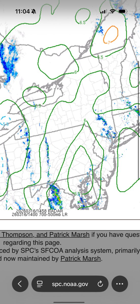
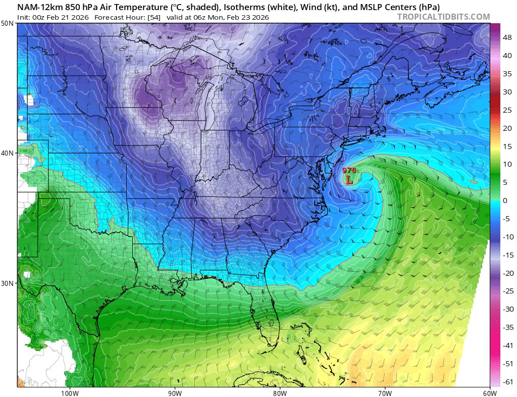
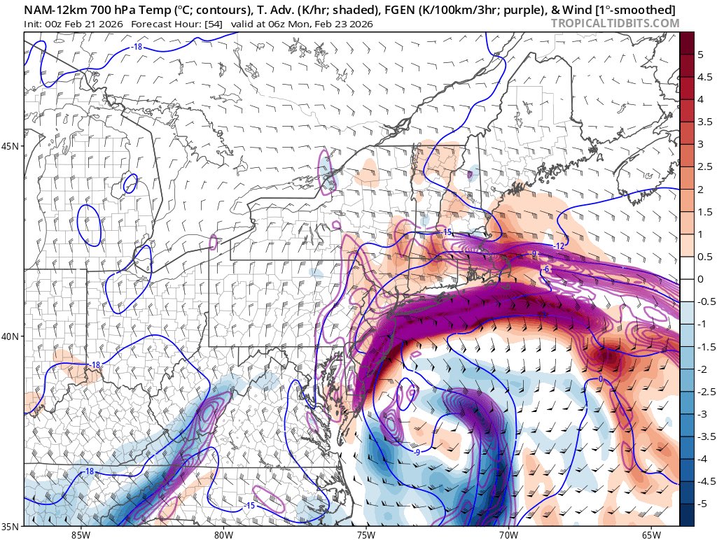
There does seem to be an EML over the area. Not super strong, but enough to
Do its part. Have to see how everythjng else evolves though.
English

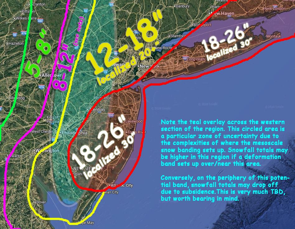
❄️Blizzard of 2026 Final Snowfall Forecast❄️- Scattered to widespread power outages possible. Coastal flooding, dangerous travel conditions expected. Please be safe out there, folks! #njwx #pawx #nywx #nycwx #ctwx
Mike Mostwill@MikeMostwill
❄️❄️Here is my first (and possibly only) call for the upcoming Blizzard of 2026. I will update once more should time (& family obligations) permit! #njwx #nycwx #pawx #nywx #ctwx Please be safe out there!!❄️❄️
English
Brian Lynch retweetledi

As the upper level trough becomes increasingly negatively tilted and the surface low rapidly deepens, the strengthening mid-level frontogenesis driven snow band is starting to pivot towards the SSW-NNE as it moves through central NJ, Long Island & NYC.
This band will eventually become quasi-stationary between the western half of NJ & far eastern PA. Intensifying snow rates driven by strengthening mid-level warm air advection & convergence are already evident over the northern Delmarva.
GIF
English
Tomer rolling around Twitter with this!!! Love it!
GIF
Tomer Burg@burgwx
❄️ FINAL FORECAST: BLIZZARD OF 2026 ❄️ Now that the snowstorm is underway, I went into a high level of detail trying to narrow down the snow band placement and evolution. Forecast reasoning follows in the thread below:
English
Brian Lynch retweetledi

@mikestanislaw 2036*! Hahaa
96, 06, 16… let’s not jinx this though!
English
Print them out and hang them on your wall, it may be a decade before you see model outputs like this again.

English
We indeed have seen models finally become less volatile today. They all converged towards the last bullet point of a 1-2+ foot storm from NJ-NYC-south New England that no models and almost no ensemble members showed just 2 days ago.
Tomer Burg@burgwx
Most crucially, today's data tells us that we are still hovering near an inflection point aloft where small short-term variability makes all the difference between: - low forms well offshore, inverted trough leads to some locally light-moderate snow in Mid Atlantic (current model consensus) - light-moderate snow across the Mid Atlantic & I-95, heavy along the coast (suggested by some of this evening's data) - major I-95 snowstorm (not currently shown by any model/ensemble, but can't be completely ruled out just yet) As relevant features start coming closer into the CONUS domain tomorrow & Friday, we'll start to see models become less volatile.
English


We’ve seen significant model adjustments for this potential early February storm over the last day, and an increasing number of deterministic & ensemble members show an intense nor’easter either just offshore or producing a major snowstorm.
If a major snowstorm is to happen, locations closer to the coast are most favored, but given a highly chaotic upstream waveguide models will continue to remain highly variable over the coming days. The best we can do at this time is monitor this potential over the coming days.

Tomer Burg@burgwx
There is a legitimate winter weather storm potential to monitor for the East Coast in early February. The large-scale ingredients are there: - Departing antecedent trough suppressing the baroclinic zone and acting as a transient 50/50 low - SW US trough entering the Gulf - Potential north stream trough being transported into the central/southern US downstream of western North American ridging There is still a lot of uncertainty and a suppressed low track is quite possible... but there is a *very* high-end ceiling for a major snowstorm if one does materialize out of these ingredients.
English
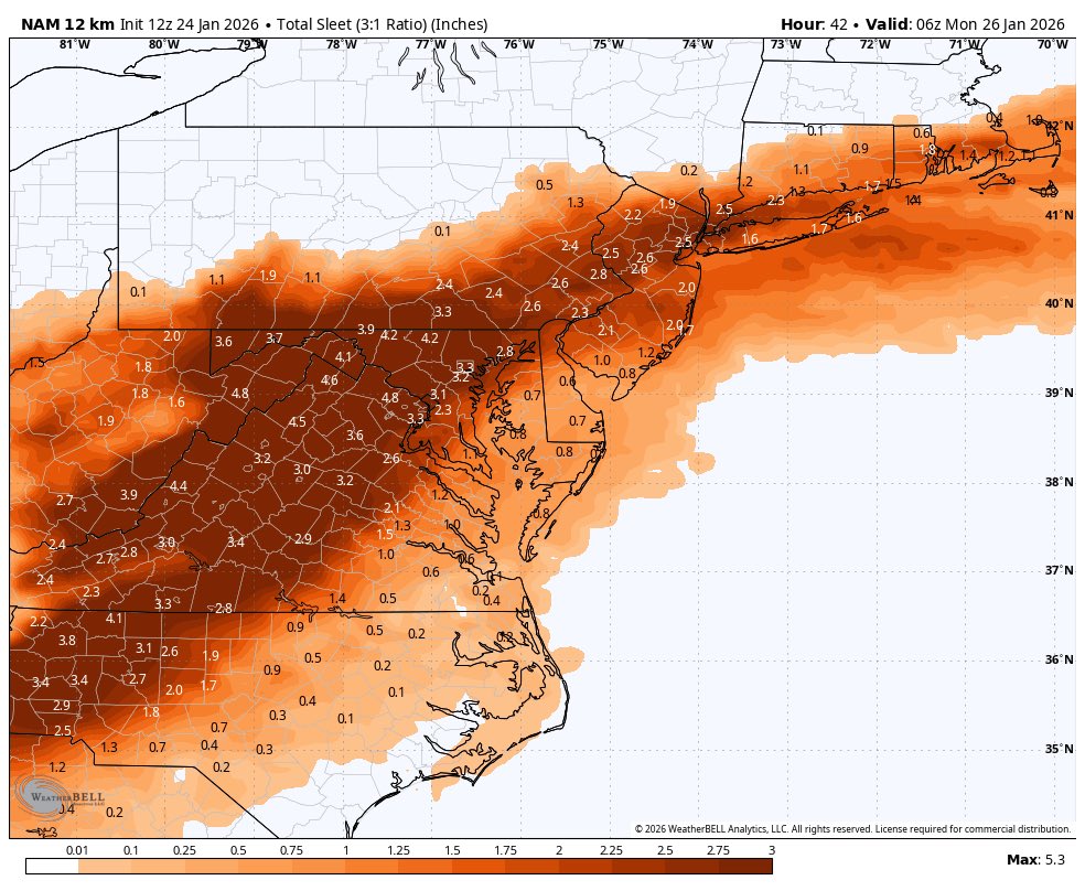
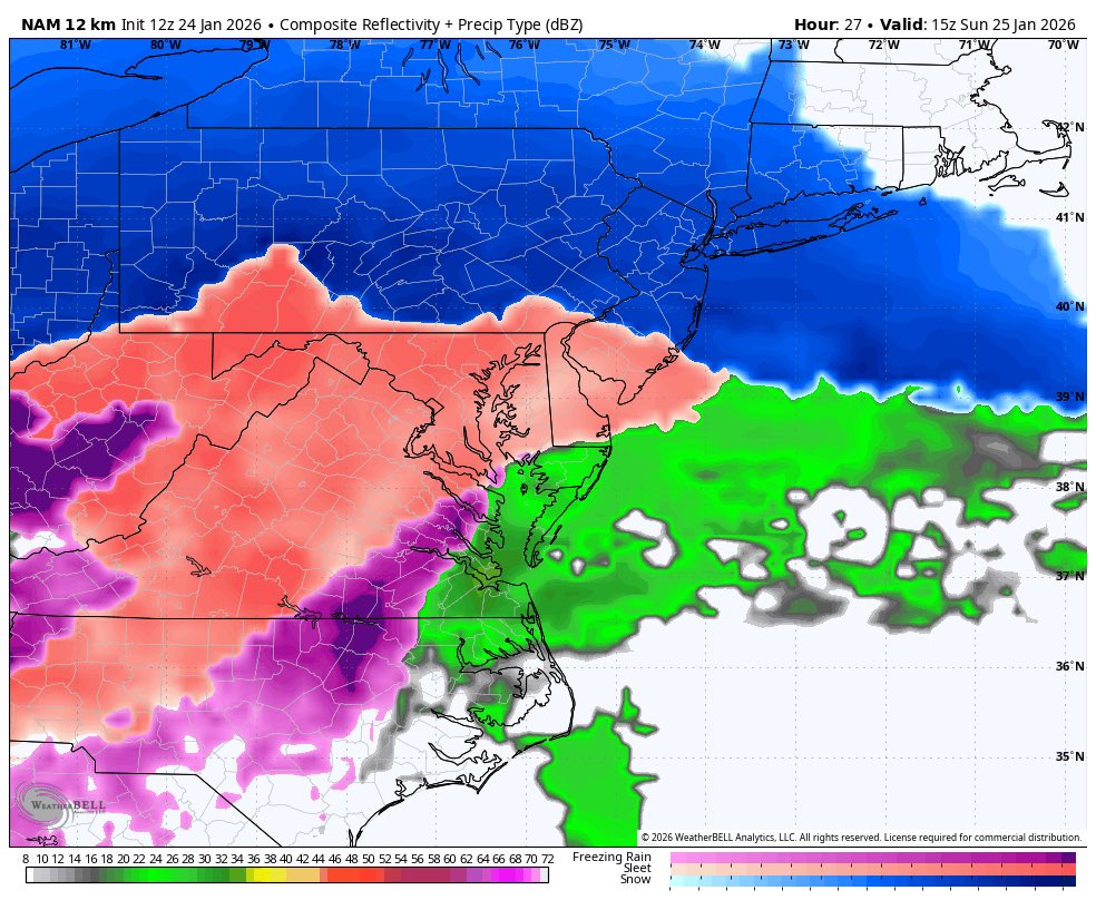
Forecast for Philly, I’ll stick to my 4-8”, 1-3” of sleet, and up to .3” ice. If we ge more sleet, then less Zr.
The sleet/zr line is gonna be the one to watch… not the snow/sleet.

English

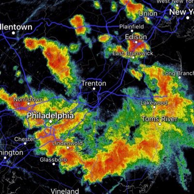
Juicy stuff in the 12z HRRR
Band of 2-3” an hour snowfall can be seen around noon
NYC still snow at 8pm


English
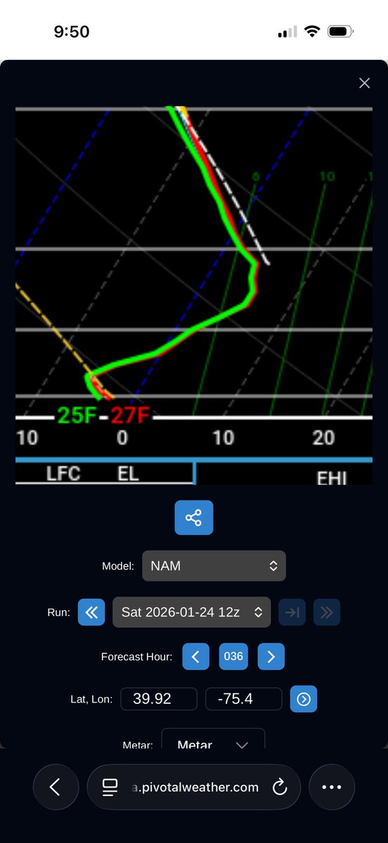
@seckhardt You’re assuming that Synoptics won’t change.. 2 days ago Richmond thought they were getting 12”
There’s still a way we can get warmer aloft faster… would open us op to more sleet/ice. Not saying it will
Happen, but I wouldn’t assume a safe snowfall for the coastal plain
English
@BLynch74 And you’ll have a ton of snowfall before that happens with that deep of a cold airmass
English
This is the airmass in place 6-12 hours before the precip starts and some people are highlighting mix in the I-95 corridor DC to NYC? Really!

English
