Manuel

5K posts

Manuel

Manuel

@Manuel679515

Katılım Ekim 2023
324 Takip Edilen153 Takipçiler
Manuel retweetledi
Jure Atanackov
Jure Atanackov@JAtanackov·
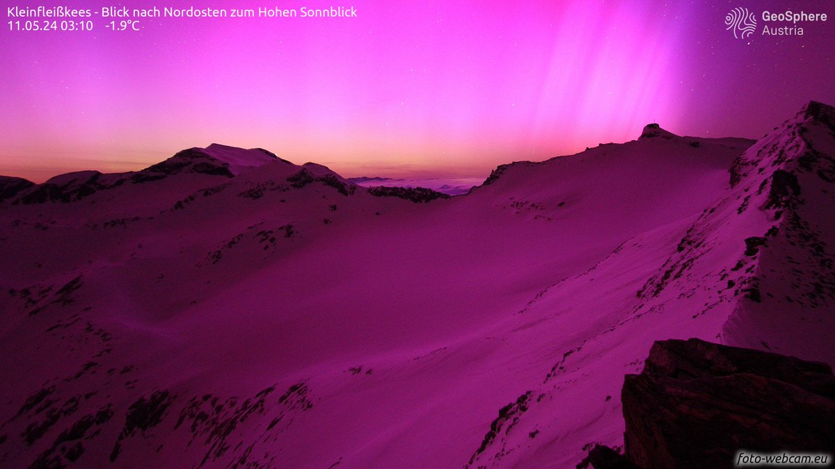
Just a few days ago was the 105th anniversary of the 15 May 1921 Great Geomagnetic Storm. The storm produced overhead aurora and corona as far south as Tucson, Arizona. That's as far south as northern Florida, central Italy and central Spain. Aurora was visually spotted at the Apia Observatory, Samoa at a geomagnetic latitude of only 16°! The storm reached an estimated minimum DST index of -907 ± 132 nT - a Carrington-level event. Compare that with the DSTmin = -406 nT during the 10-11 May 2024 G5 Gannon storm.
Jure Atanackov tweet media
English
4
21
68
18.4K
Manuel retweetledi
Roberto Granda
Roberto Granda@EnMet3·
Se me ha llenado (oh, sorpresa) el tuit de gente que mezcla el tocino con la velocidad y, de forma muy clara, no sabe ni de qué habla. Hay zonas de la vertiente atlántica donde es evidente la bajada. Igual que otras, sobre todo en el entorno del sistema Ibérico. Datos.
Roberto Granda tweet mediaRoberto Granda tweet mediaRoberto Granda tweet mediaRoberto Granda tweet media
Español
1
2
13
1.2K
Manuel retweetledi
Roberto Granda
Roberto Granda@EnMet3·
No, España no se humedece. Esto es lo que pasa cuando la gente coge dos mapas distintos, con metodologías distintas, y se queda tan pancha. Pero claro, mentir sale gratis... En casi todo el país la tendencia es a pérdida de precipitación si usamos un conjunto común desde 1961.
Roberto Granda tweet media
Español
22
49
217
18.8K
Manuel retweetledi
carlos/virazón
carlos/virazón@globerourdiales·
Un patrón dominante ATR( dorsal atlántica) provocará flujo de aire frío hacia el suroeste de Europa durante esta semana. precipitaciones abundantes en la mitad norte peninsular. Al final de semana se impondrá el patrón de NAO ligeramente positiva
carlos/virazón tweet mediacarlos/virazón tweet mediacarlos/virazón tweet mediacarlos/virazón tweet media
Español
0
4
48
2.5K
Manuel retweetledi
Ben Noll
Ben Noll@BenNollWeather·
Meet the El Niño twins: 2026 and 1997. They aren't identical, but they sure have a lot of similarities. Exceptionally warm waters were closer to the Pacific Ocean surface at this time in 1997, but 2026 is breaking records for warmth at depth. Which twin will win? Stay tuned!
Ben Noll tweet media
English
26
365
1.3K
98.4K
Manuel retweetledi
Denoxx
Denoxx@Denoxx06·
Estofex yarın için fırtına tahmini 2 ile işaretli yerler Şiddetli hava koşulları görülebilir ⛈️❗
Denoxx tweet media
Türkçe
3
6
43
6K
Manuel retweetledi
Elpito meteo
Elpito meteo@MeteoElpito·
DIMARTS FESTIVAL TEMPESTUÓS A CATALUNYA Demà dimarts estarem entre 2 branques del JET STREAM (veure mapa). Que significa ser dins aquesta zona? .....que estarem en ple camp de batalla entre dues masses d'aire de característiques diferents. Resultat? Tempestes a tota Catalunya
Elpito meteo tweet media
Català
1
42
299
14K
Manuel retweetledi
Aigle
Aigle@Aigle_e·
🥶Les prochains jours s'annoncent très frais! ➡️Un état de fait de plus en plus rare. Cette semaine, les températures seront fréquemment <5°C sous les normales, motivées par un flux de Nord. ➡️Cette séquence est probablement motivée par le passage de la MJO 3-4 + AAM neutre.
Aigle tweet mediaAigle tweet mediaAigle tweet mediaAigle tweet media
Français
2
3
76
3.9K
Manuel retweetledi
Aigle
Aigle@Aigle_e·
🆕Today's C3S update reflects almost perfectly what pressure pattern you would expect under a Strong El Niño summer worldwide. 🇪🇺 Europe: -NAO. Hot summer; dry (North), stormy (South). 🌊Indo-Pacific: Strong SLP dipole. 🧊Arctic: -AO. ➡️Both fit analogs & modelling studies.
Aigle tweet mediaAigle tweet mediaAigle tweet media
English
5
9
58
7.8K
Manuel retweetledi
Météovillages
Météovillages@meteovillages·
⛱️🔥 Les prévisions saisonnières pour l'été 2026 sont peu encourageantes. 🔸Un schéma propice aux canicules et aux feux de forêt se dessine dans les nouvelles prévisions de Mai du modèle européen pour cet été. Les autres modèles saisonniers mondiaux seront réactualisés demain.
Météovillages tweet mediaMétéovillages tweet mediaMétéovillages tweet mediaMétéovillages tweet media
Français
19
22
142
14.8K
Manuel retweetledi
Jure Atanackov
Jure Atanackov@JAtanackov·
On this day 2 years ago: 10-11 May 2024 G5 Gannon geomagnetic superstorm. The views of the aurora spectacle over the Alps were otherworldly! Rarely is the sky as far south as the Alps filled with aurora.
Jure Atanackov tweet mediaJure Atanackov tweet mediaJure Atanackov tweet mediaJure Atanackov tweet media
English
3
38
186
8.6K
Manuel retweetledi
carlos/virazón
carlos/virazón@globerourdiales·
El 'coletazo polar tardío' previsto para jue/vie puede afectar a frutales de hueso (cereza, melocotón, albaricoque), frutos secos (almendros) y quizás algún viñedo. pero por otro lado en tiempos de calores tempranos es buena noticia mantener a raya las masas de aire africanas
carlos/virazón tweet mediacarlos/virazón tweet mediacarlos/virazón tweet mediacarlos/virazón tweet media
Español
2
6
76
4.3K
Manuel retweetledi
ValènciaWeather⚡️
ValènciaWeather⚡️@Valencia_WX·
De momento así van las tormentas. Van de sur a norte. De momento más o menos lo previsto aunque quizás más persistentes al sur de Alicante ahora mismo.
ValènciaWeather⚡️ tweet media
Español
4
4
43
3.8K
Manuel retweetledi
ValènciaWeather⚡️
ValènciaWeather⚡️@Valencia_WX·
⚠️⛈️Se adelantan las tormentas que se esperaban para hoy El sistema avanza hacia el NE ⚡️El principal riesgo son los rayos, ademas de lluvia intensa
ValènciaWeather⚡️ tweet media
Español
4
21
118
14.5K
Manuel retweetledi
AEMET
AEMET@AEMET_Esp·
🧵 El pasado mes batió récords: fue el abril más cálido de la serie histórica en España. ➡️ Con una temperatura media de España de 15.1 °C, superó en una décima al abril más cálido hasta ahora, el del año 2023.
AEMET tweet media
Español
22
78
144
26.2K
Manuel retweetledi
Meteociel
Meteociel@meteociel·
Une #vigilanceOrange 🟠 #pluie/inondation est mis en place pour cette nuit dans le #Gard et l'#Hérault. Un épisode méditerranéen est en cours, il est attendu cette nuit des cumuls de 50 à 100 mm sur des secteurs où il est déjà tombé 80 à 120 mm ces dernières heures.
Meteociel tweet mediaMeteociel tweet media
Français
0
2
23
2K
Manuel retweetledi
Roberto Granda
Roberto Granda@EnMet3·
Hemos cerrado el abril más CÁLIDO desde que hay datos en España. Las anomalías han alcanzado los +4ºC en amplias zonas del interior. En máximas, hasta por encima de +6ºC. Seguro que aún hay quien lo niega, claro... dentro hilo 👇 (datawrapper.de/_/OiK8D/)
Roberto Granda tweet media
Español
12
160
285
17.1K
Manuel retweetledi
Pablo Brisa Vega
Pablo Brisa Vega@pablobv10·
Las próximas semanas, tendremos bastante inestabilidad. Varios sistemas de bajas presiones que se pueden convertir en DANAs, bajarán en latitud dando lugar a un mes de mayo bastante movidito. 🌧️
Pablo Brisa Vega tweet mediaPablo Brisa Vega tweet mediaPablo Brisa Vega tweet mediaPablo Brisa Vega tweet media
Español
0
4
49
3.7K