
12345
67 posts


@NashSevereWx @chainsawalicee Are you cleaning out your closet for this one? Or have we seen worse this season?
English
@chainsawalicee Not sounding alarm bells right now. But we’re concerned about the levels of storm ingredients present.
English
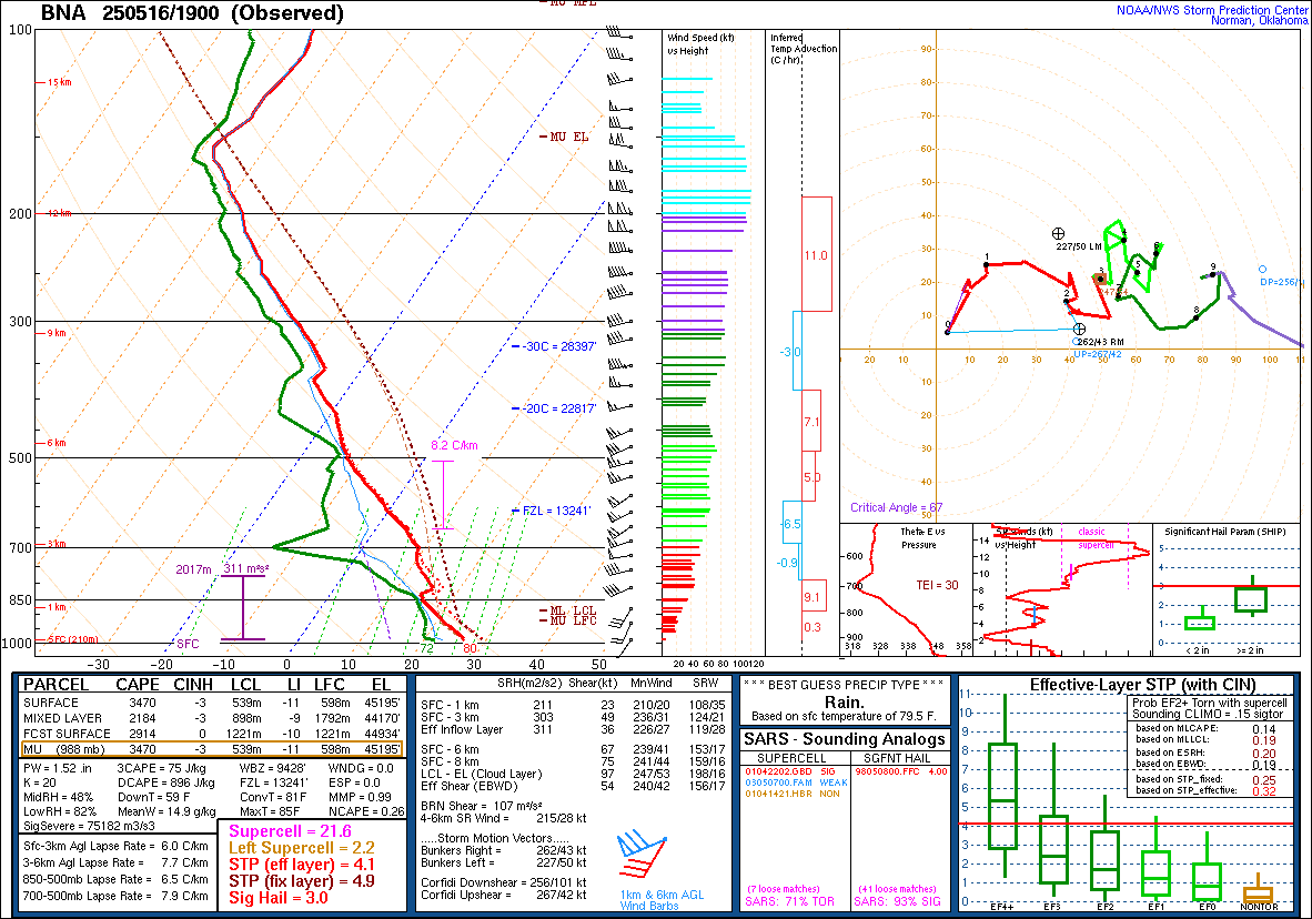
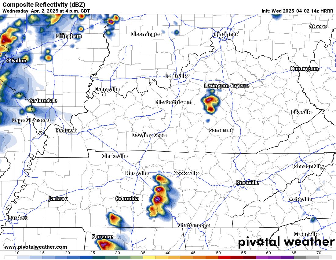
A special 2 PM weather balloon sounding from Nashville shows an atmosphere primed for dangerous storms. Ingredients are in place for supercells capable of producing large hail, damaging winds, and tornadoes. Timing still after dark / overnight. If storms fire, they could become intense quickly. Stay weather aware this evening and have multiple ways to receive warnings.
English

This honestly may be one of the most insane observed soundings I have ever seen in Nashville.
English
New HRRR model run drives morning storms just north of us. These'll be watched. Main concern is Friday night after dinner, but ETAs often change at this rain. All svr modes possible: damaging straight line winds, hail, and yes, tornado. More in the morning.

English
I don't see any way those storms are going to make it here tonight. All tornadomaking ingredients are to our SW.
Jameson Stafford@jjstafford
@NashSevereWx Is this not going to make it here, or….?
English
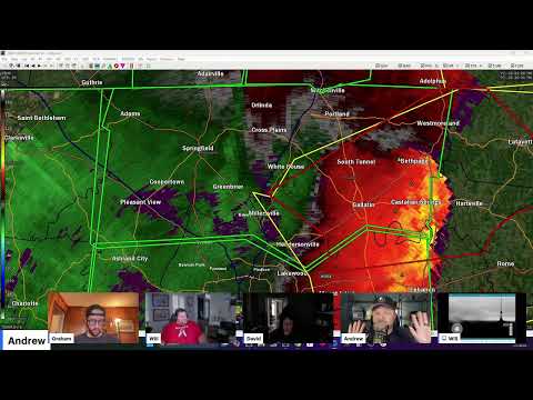
Overview: most of the big wind/tornado drama has GONE EAST as this event transitions to a Flash Flood Warning dohickey. Trees are down. Avoid flooded roads. Do not approach downed power lines! We are live here: youtube.com/watch?v=ua5QkB…
YouTube

English
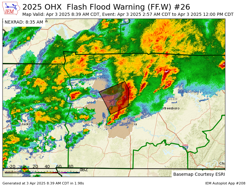
OHX extends time of Flash Flood Warning [flash flood: radar indicated, flash flood damage threat: considerable] for Cheatham, Davidson, Dickson, Hickman, Maury, Williamson [TN] till Apr 3, 12:00 PM CDT mesonet.agron.iastate.edu/vtec/f/2025-O-…
English

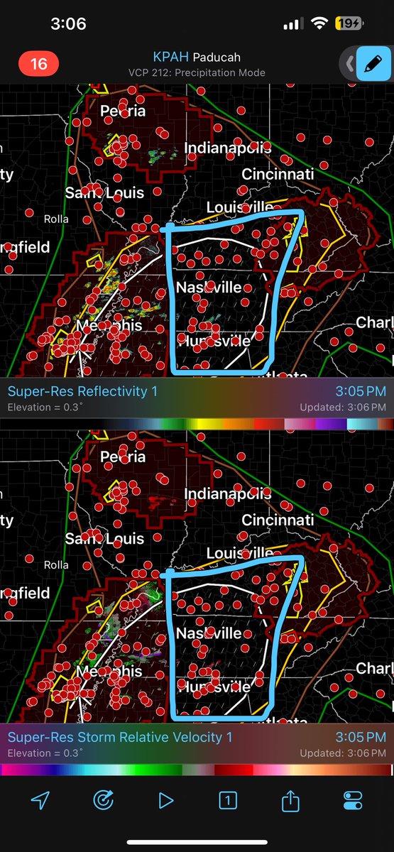
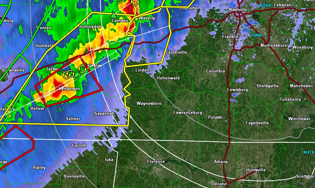
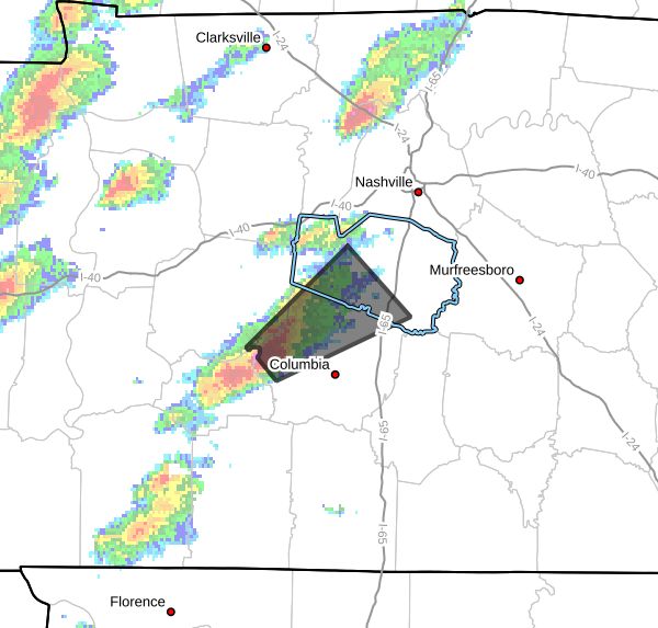
Storms containing both Severe Thunderstorm and Tornado Warnings moving East and Northeast towards us. Still 45 minutes to an hour away. Could be warned sooner especially the North part of Maury County.
English
Main line ETA around midnight, maybe an hour or two later. Heavy rain, lightning, strong winds and brief tornadoes will be possible. Have ways to get warnings and a safety plan in case you need to take cover. We'll be with you the whole way. / 817 PM

English
Last two HRRR model runs show a brand new potential concern: mid afternoon supercells somewhere in Middle TN which could produce tornadoes. This was not in the forecast (or in any of the data) this morning, so take it with a grain of salt. We don't hide data from you. Takeaway: pay attention to the weather ALL DAY, not just tonight. / 1026 AM

English
@NashSevereWx I really appreciate that you don’t use scare tactics like some of these other people.
English
Coupleuh reminders. 1) This is nothing unusual for us this time of year in Nashville. I've lived here nearly 40 years and have spent many nights in the safe room in those years. We'll get through it together. 2) Not every storm will be severe. The odds are in your favor. But, take the threat seriously. Be wise.
English

Thoughts don't change. Big Hail and damaging winds day tomorrow. A tornado threat seems to be still apparent, but the highest is SW.
Brandon Lane@BrandonLaneWX
Thoughts on tomorrow. 1. Need to watch for possible morning convection, could limit intensity of afternoon storms. 2. Very large Hail seems so be the biggest threat atm. Probably seeing some baseballs falling. 3. The tornado threat is there, but I don't see it being elevated. I honestly don't think Southern Indiana warrants a 10%# atm. NAM is the only model screaming tornados (which is typical) but still needs watching. 4. Could have multiple waves. The first wave would be big hailers and bowing segments. 2nd would be a possible organized squall line/cluster close to sunset (damaging winds biggest threat). 5. I expect a moderate upgrade for Hail and Wind. Will update more if needed. Stay weather aware.
Columbus, IN 🇺🇸 English
@NashSevereWx 2% then why is reed timmer circling our area for tornados. Now I feel uneasy 😟
English
SPC increased probabilities of X within 25 mi of us tonight for 1" hail (was 5%, now 15%) and damaging straight line winds (was 5%, now 15%). Tornado remains 2%. Right now non-severe thunderstorm is tossing lightning heading for North Nashville and East Nash / 1143 AM

English
🛏️ OK for bed: those in Davidson and Williamson Cos West of 65, East Nashville, Madison / 1040 PM
English
Here's what the NWS says about the storm to our south.
At 738 PM CDT, Doppler radar was tracking a strong thunderstorm 9
miles northwest of Mount Pleasant, or 13 miles west of Columbia,
moving northeast at 45 mph.
HAZARD...Wind gusts up to 50 mph and pea size hail.
SOURCE...Radar indicated.
IMPACT...Gusty winds could knock down tree limbs and blow around
unsecured objects. Minor hail damage to vegetation is
possible.
English
I can not stress this enough. This is a very bad situation. We have multiple dangerous tornadoes ongoing.
If you are out ahead of this line, you might as well go ahead an seek shelter or be close to your shelter.

English
ETAs as of 9:06 pm, if the line of storms keeps its current speed, here's what we're looking at. 9:40ish for Joelton. 9:50 pm downtown, 9:55 Franklin

English
@NashSevereWx Are we in the red? Is that worse than the yellow hatched area?
English
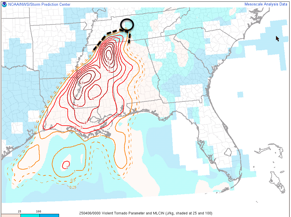
We use many forecasting tools. As those tools have advanced, we've also seen AI start to play a role, and sometimes those tools have done pretty well. One of those tools we take into account is why I'm not sleeping on the tornado potential tonight. This, along with the SPC forecast, is why we want you to be prepared with multiple warning sources after 8pm.

English