
Bela Trimmel
593 posts

Bela Trimmel
@belaj
Dreadfully boring book worm, hooker with open side flanker predictions, highland athlete. Beer, tea, and scotch snob.
Tennessee Katılım Kasım 2008
0 Takip Edilen18 Takipçiler

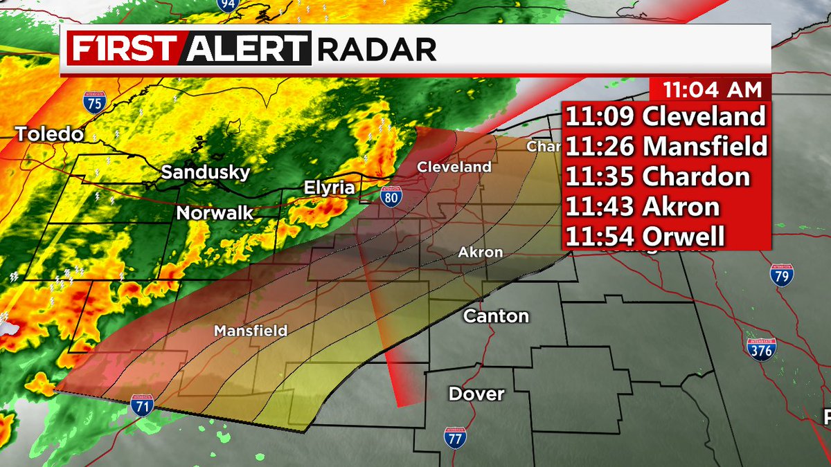
Radar Update 11:05 AM: Non-severe showers and storms continue to move through Northeast Ohio. Stormy skies will stick with us through lunchtime before gradual clearing expected early this afternoon. ⛈️ #ohwx

English
@ErikaPaigeWX in the Akron area and was curious if you think that level 2 risk pushes just a bit further East to cover us.
English
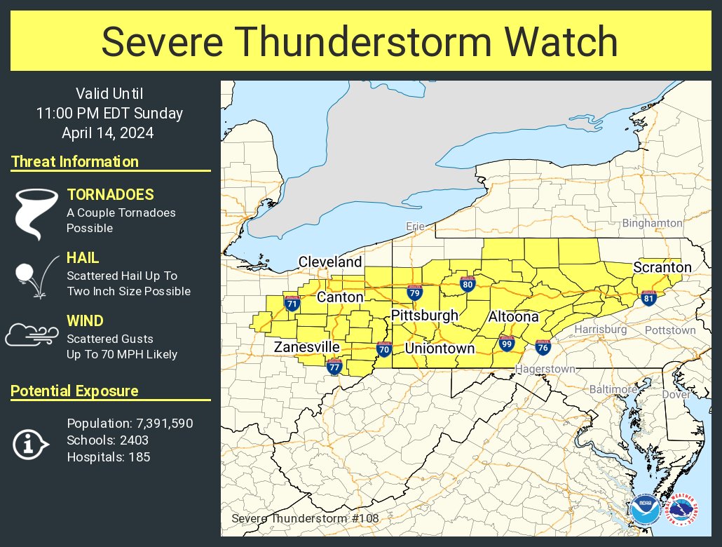
A severe thunderstorm watch has been issued for parts of Ohio, Pennsylvania and West Virginia until 11 PM EDT
Pennsylvania, USA 🇺🇸 English


@ArmyGunner1122 @NWSCLE Most weather apps change as conditions do in an effort to be most accurate. Give it an hour or two and it’ll probably change again
English
@NWSCLE Super technical question but I’m in the Akron area, how fuzzy is that line between level 2 and 3?
English
@NWSCLE Is there any likelihood that the zones shift back north later today?
English
There has been a slight shift southward with the greatest severe risk. However stay weather alert with all hazards remining possible.
English

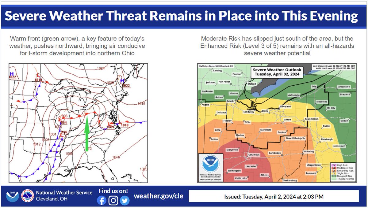
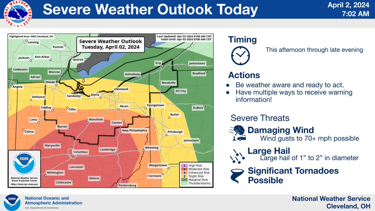
11:32am CDT #SPC Day1 Outlook Enhanced Risk: Parts of southern Lower MI, northern OH, and northwest PA spc.noaa.gov/products/outlo…

English
@NWSCLE do you expect the weather back toward Columbus to move into NE Ohio?
English
@JasonNweather Are you thinking the storms around Wooster/Mansfield to push into the Hudson/Stow area?
English

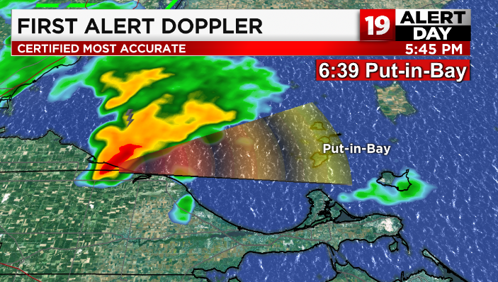
Heads up PUT-IN-BAY. Strong storm (with a tornado warning history) is heading your way. ETA around 6:30p. Expect heavy rain, gusty winds, lightning and possible hail. Cannot rule out rotation as this storm has been spinning a bit. Stay safe.
English
A special weather statement has been issued for Cleveland OH, Parma OH and Lorain OH until 8:30 PM EDT

Ohio, USA 🇺🇸 English
@NWSCLE Any thoughts about the ‘slight’ risk expanding eastward any?
English
Severe thunderstorms may impact northern OH late tomorrow afternoon and early evening, especially in the yellow shading. Damaging wind gusts and a brief tornado are possible. #OHwx
English
@ryanhallyall any advice on when I should salt my driveway? Chang over from rain to snow should be around 3am
English
The arctic cold front is on the doorstep of the OH/IN border this evening, extending even as far south as the Gulf Coast! The image on the right shows the current wind chill temperatures while the image on the right shows the temperature difference over just the past hour.

English
@NWSCLE Weather apps keep saying rain for tomorrow, into tomorrow night. Thoughts?
English

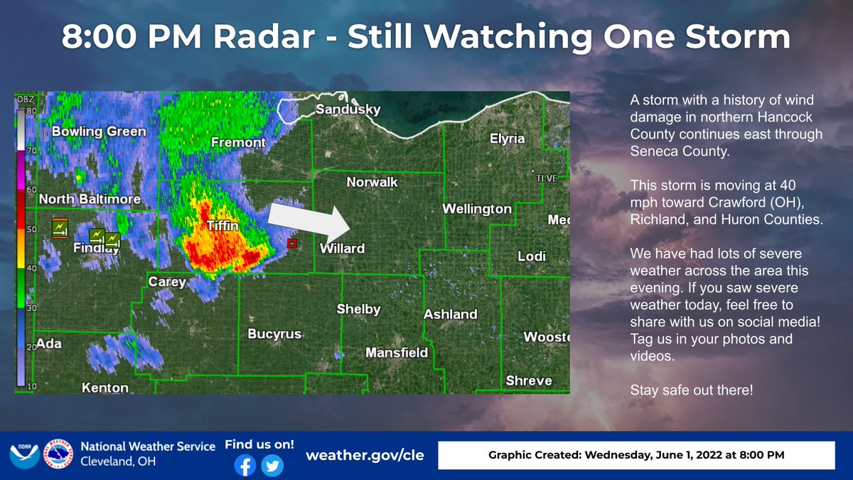
A storm with a history of wind damage in northern Hancock County continues east through Seneca County. This storm is moving east at 40 mph. We have had lots of severe weather across the area this evening. If you saw severe weather today, feel free to share with us on social media
English
@DanielleBreezy Do we expect any non severe storms this evening? Have outdoor plans that are fine with rain but once electricity gets involved it’s all over.
English

Much of Middle Tennessee is under a Moderate Risk for excessive flooding. Flash flooding along with rising rivers and creeks is a concern through tonight. Stay weather alert! wrkn.com/weather?utm_me…

English
@NashSevereWx Even if it’s not severe, could we still see lightening with the storms? Got outdoor practice this evening.
English
By looking at proxy severe storm indicators such as STP (Significant Tornado Parameter), we see the absence of local severe storm ingredients when the orange and yellow precip gets to us tonight. That's a clue:
4/
GIF
English
Forecast Update/Changes
More heavy rain and storms will form later this afternoon and tonight. For Davidson/Williamson this will be mainly a flash flood concern, not so much a storm concern, why we think so: a thread.
1/13
English
@NashSevereWx Heading East this weekend. Do you guys recommend an account for the Knoxville area?
English
Expect this forecast to change a bit. Do not rely on old information. Stay updated and get new information.
We will be with you the entire way.
GIF
English
👀
Storm Prediction Center has increased the concern level for severe weather 👉🏽 Friday, likely late Friday night, overnight, into Saturday morning.
An 8:30 AM Thursday thread 🧵 about Hazards, Probability, Timing, & Preparedness
English
@NashSevereWx sun is out in Franklin. With temps and dewps like they are, is storm development in play for the afternoon/early eve?
English