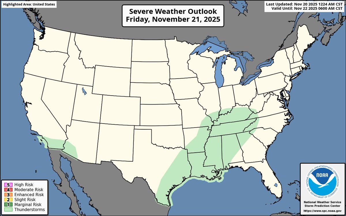
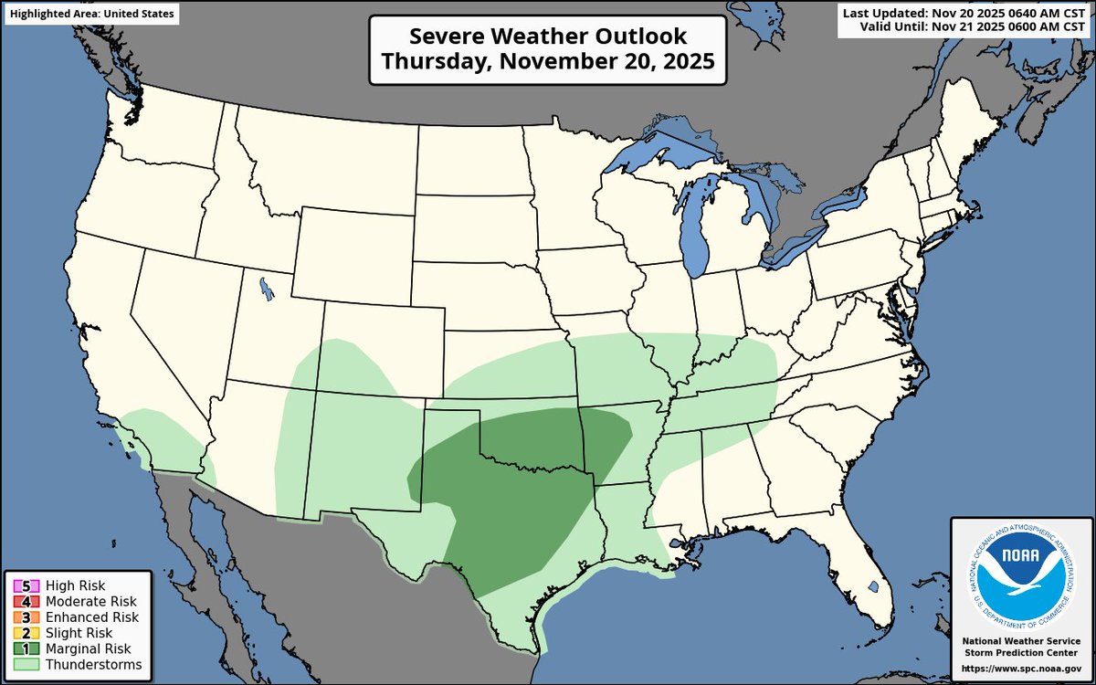
Kyle Roberts

24.1K posts

Kyle Roberts banner
Kyle Roberts

Kyle Roberts

@KyleWeather

Former TV meteorologist (@wfaa, @okcfox, @ketk) | B.S. in Meteorology from Texas A&M (@TAMU)

DFW, TX انضم Aralık 2009
483 يتبع8.1K المتابعون
تغريدة مثبتة
Kyle Roberts
Kyle Roberts@KyleWeather·
After 8+ years at @wfaa, I’ve decided to step away and close this chapter of my career. Growing up watching, interning, and then working there has been a dream come true! My last day was Sunday. Thank you for all the support! Here’s to new beginnings! youtu.be/CQ0wnSJUv9o?si…
YouTube video
YouTube
English
65
15
507
42K
Kyle Roberts
Kyle Roberts@KyleWeather·
But I thought according to Facebook and #wxtwitter we were supposed to have a multiday significant severe weather outbreak going on right now...🧐
Kyle Roberts tweet mediaKyle Roberts tweet mediaKyle Roberts tweet media
English
0
0
3
456
Kyle Roberts
Kyle Roberts@KyleWeather·
You’d hate how late sunrises are in the middle of winter if we stayed on DST year round.
Kyle Roberts tweet media
English
1
0
1
363
Kyle Roberts أُعيد تغريده
NOAA's Ocean Service
NOAA's Ocean Service@noaaocean·
NOAA is flying over over the area affected by Hurricane Melissa to support disaster response efforts in Jamaica. Find all the available imagery in our viewer: #7.82/18.238/-77.556" target="_blank" rel="nofollow noopener">storms.ngs.noaa.gov/storms/melissa…
NOAA's Ocean Service tweet media
English
25
381
1K
457.5K
Kyle Roberts أُعيد تغريده
Tropical Cowboy of Danger
Tropical Cowboy of Danger@FlynonymousWX·
Third pass through Melissa. GoPro in side window as different camera looking forward shooting in ultra high res 8k. Not sure when that might get processed as the file turned out ridiculous. Barely had HD space for it and MacBook Pro promptly chocked when I tried to edit it
English
89
2.1K
9.7K
1.3M
Kyle Roberts
Kyle Roberts@KyleWeather·
It’s 2025 I still don’t know what is and what isn’t “targeting”
English
1
0
6
769
Kyle Roberts
Kyle Roberts@KyleWeather·
Closest lightning strike to Kyle Field was 11.5 miles not within 8 miles. I’d say @TAMUMeteorology got this one right. Sorry @espn… Now fix the cameras please.
Kyle Roberts tweet media
English
0
0
6
600
Kyle Roberts أُعيد تغريده
Matthew Cappucci
Matthew Cappucci@MatthewCappucci·
BREAKING: An incredible "gigantic jet" – an extremely-rare type of upper-atmospheric lightning – was photographed from the International Space Station on Friday morning. This is the clearest photo we have EVER seen of a gigantic jet from above. Nichole Rhea Ayers is a major in the U.S. Air Force and a NASA astronaut. She launched to the International Space Station as a pilot of the SpaceX Crew-10 mission on March 14, and will be returning to Earth soon. On Thursday morning, July3, she captured an unbelievable photo of an ultra-rare GIANT JET. The International Space Station was over Mexico and the southern U.S. at the time. It looks like the instigating thunderstorm was happening somewhere near Sabinas in Coahuila, Mexico around 1:30 a.m. Central time Thursday. Gigantic jets are a subset of “blue jets,” which themselves are a type of TLE — or transient luminous event, often referred to as “upper-atmospheric lightning.” There are different types of TLEs, including red “sprites,” green “elves” and blue jets. Blue jets are the rarest. Elves and sprites occur high above thunderstorms, but jets bridge a key gap between a thunderstorm and the stratosphere high above. Sometimes they even reach up to the base of the mesosphere — the height at which meteors burn up! They begin as a cloud-to-air discharge that emanates out the top of thunderstorms, but immediately grow to MASSIVE sizes — up to 30 miles tall! They shoot upwards at speeds of 6 to 90 miles PER SECOND, but only last two or three tenths of a second. They are bright blue (almost like a neon sign, since they are plasma after all). The blue color is believed to stem from “excited” nitrogen. It’s believed that blue jets start as an ordinary lightning strike in the top of thunderclouds, where abundant positive charge is present. Sometimes there’s a negative charge in the clear air above. Instead of the negative charge flowing down to balance out the positive, sometimes the positive shoots upwards into the clear negative skies above. The result? A positive discharge that propagates upwards. Gigantic jets are even more spectacular. Emerging research suggests they begin as a discharge between negative charge in the mid-levels of the cloud and the positive tops of clouds. That leads to a *negative* “leader” of electricity that shoots upwards and escapes the cloud before it can actually discharge and “balance out” charge within the cloud. You can tell this one was a “gigantic jet” because of the reddish tops that resembles the stem of a carrot. That’s a sign the gigantic jet reached even higher altitudes — perhaps 50 to 60 miles above the ground. Atmospheric electrodynamicists (the fancy term for folks who study lightning) are learning about all sorts of never before-discovered lightning discharges. Most of what we know comes from photos like this! In recent years, scientists have coined new terms for curious, fleeting discharges — “trolls”, “pixies”, “ghosts” and “gnomes”. The existence of upper-atmospheric wasn’t known until July 6, 1989, when a researcher named R.C. Franz left a camera running overnight to capture the night sky. For decades, pilots had reported seeing strange red and blue flashes above thunderstorms, but it wasn’t until Franz obtained photographic evidence that scientists were able to delve deeper into the mystery. Nowadays, most of what we know comes from photographers who happen to get lucky — especially since the flashes usually last only a couple milliseconds. Ayers’ photo is truly a one-of-a-kind capture that will hopefully shed more light on how TLEs behave.
Matthew Cappucci tweet mediaMatthew Cappucci tweet mediaMatthew Cappucci tweet media
English
170
1.7K
10.1K
819.4K