RyanWeather.Com

141.5K posts

RyanWeather.Com banner
RyanWeather.Com

RyanWeather.Com

@Ryan541

Southern Oregon and Northern California weather updates. My website links to weather data live from Medford, Oregon. Hourly weather updates 24/7/365.

Medford, Oregon انضم Nisan 2009
128 يتبع2.2K المتابعون
RyanWeather.Com
RyanWeather.Com@Ryan541·
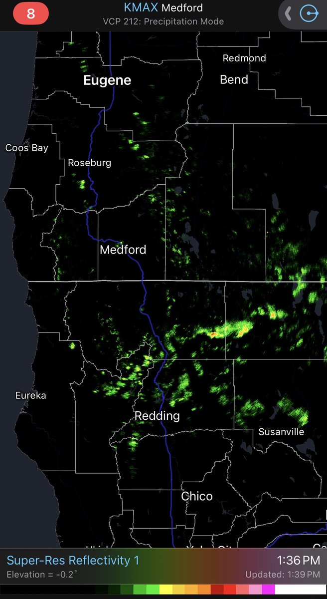
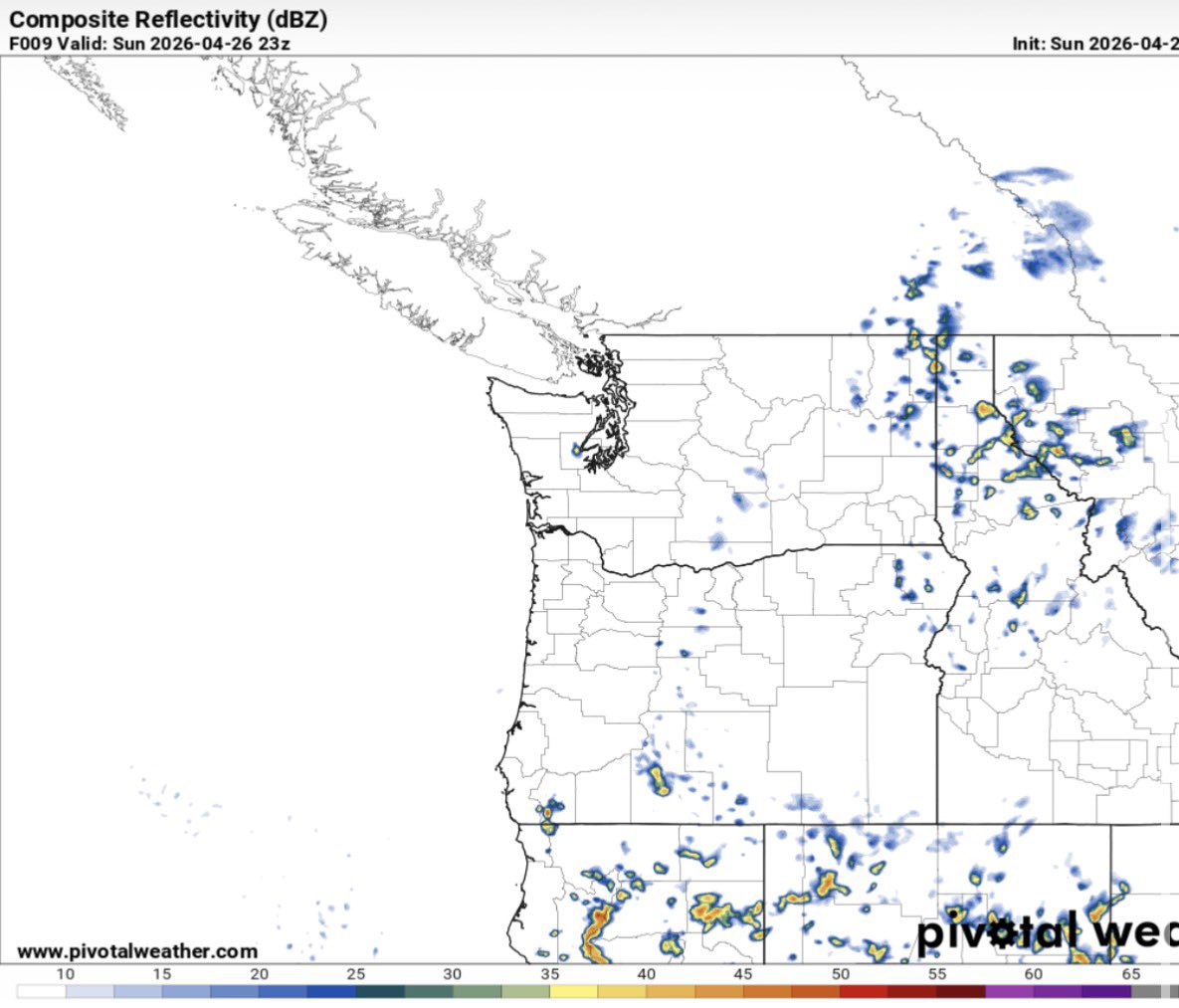
With a trough overhead and clear skies for most locations, we could see temperatures drop into the 30’s west of the Cascades. If you have frost sensitive plants you will want to protect them from damage.
RyanWeather.Com tweet media
English
0
2
6
60
RyanWeather.Com
RyanWeather.Com@Ryan541·
Thunderstorms are active again this afternoon across Siskiyou and Modoc counties. Here is a look at radar returns and lightning strikes recorded in the last 20-60 minutes.
RyanWeather.Com tweet mediaRyanWeather.Com tweet media
English
0
1
5
152
RyanWeather.Com
RyanWeather.Com@Ryan541·
The HRRR model composite reflectivity this morning is indicating we could see an isolated showers to develop over eastern Curry/western Josephine County later this afternoon. The rest of the potential for thunderstorms will be across Siskiyou, Modoc, Klamath and Lake counties.
RyanWeather.Com tweet media
English
0
1
6
100
RyanWeather.Com
RyanWeather.Com@Ryan541·
A beautiful morning in the Rogue Valley from the Phoenix, OR webcam. Higher level clouds are streaming overhead across the region today.
RyanWeather.Com tweet media
English
0
2
6
65
RyanWeather.Com
RyanWeather.Com@Ryan541·
The 80’s look to make a return as we head into late next week. Here is a look at the projected highs across the region on Thursday.
RyanWeather.Com tweet media
English
0
2
8
108
RyanWeather.Com
RyanWeather.Com@Ryan541·
The 48 hour accumulated precipitation estimates shows where showers and thunderstorms are most likely to produce measurable rainfall through 5 AM Tuesday.
RyanWeather.Com tweet media
English
0
2
4
55
RyanWeather.Com
RyanWeather.Com@Ryan541·
The Storm Prediction Center at NOAA does show thunderstorm potential continuing again today across portions of Siskiyou, Modoc, Klamath and Lake counties later this afternoon and evening. Similar to yesterday these will isolated to scattered in nature.
RyanWeather.Com tweet media
English
0
1
3
58
RyanWeather.Com
RyanWeather.Com@Ryan541·
High temperatures today will cool a few degrees in response to the weak trough overhead. Here are the current GFS model temperatures outlooks across the region.
RyanWeather.Com tweet media
English
0
2
3
63
RyanWeather.Com
RyanWeather.Com@Ryan541·
Satellite imagery this morning shows where the fog and low clouds are positioned along the coast. This has extended inland across some of the western interior valleys. Areas of clouds are also in place across Northern California and east of the Cascades.
RyanWeather.Com tweet media
English
0
2
10
91
RyanWeather.Com
RyanWeather.Com@Ryan541·
The snow is melting off quickly along the caldera walls at Crater Lake. You can see this quite well on the Sinnott Overlook webcam this evening.
RyanWeather.Com tweet media
English
0
2
7
120
RyanWeather.Com
RyanWeather.Com@Ryan541·
The latest 8-14 day temperature and precipitation outlooks from the Climate Prediction Center indicate we will trend toward above normal temperatures and near to below normal precipitation heading into the first full week of May.
RyanWeather.Com tweet mediaRyanWeather.Com tweet media
English
0
2
7
83
RyanWeather.Com
RyanWeather.Com@Ryan541·
A few active thunderstorms are developing in Modoc County. Here is a look at the radar returns and the recorded lightning strikes in the last 20-30 minutes.
RyanWeather.Com tweet mediaRyanWeather.Com tweet media
English
0
1
2
56
RyanWeather.Com
RyanWeather.Com@Ryan541·
Radar returns are picking up on a few showers and possibly an isolated thunderstorm developing in Modoc County this afternoon.
RyanWeather.Com tweet media
English
0
1
4
55
RyanWeather.Com
RyanWeather.Com@Ryan541·
Here is the latest GFS model run showing 24 hour precipitation estimates. As you can see the bulk of the rain will be focused across Siskiyou and Modoc counties today.
RyanWeather.Com tweet media
English
0
1
4
66
RyanWeather.Com
RyanWeather.Com@Ryan541·
Here is the latest general thunderstorm outlook from the Storm Prediction Center at NOAA. Areas in light green could see thunderstorms develop during the day today through the evening hours. Gusty winds, lightning and small hail are possible.
RyanWeather.Com tweet media
English
0
1
4
57
RyanWeather.Com
RyanWeather.Com@Ryan541·
High temperatures today will trend above normal across the region. Here is a look at the GFS model run forecast highs.
RyanWeather.Com tweet media
English
0
1
1
55
RyanWeather.Com
RyanWeather.Com@Ryan541·
Visible satellite imagery is showing more clouds overhead this morning. This is in response to a weak disturbance that is moving over the region. We will see potential for thunderstorm development today across portions of Northern California.
RyanWeather.Com tweet media
English
0
1
1
51
RyanWeather.Com
RyanWeather.Com@Ryan541·
High pressure is firmly in place across the region but a weak area of low pressure just offshore of Northern California will provide enough upper level moisture and instability to generate a few thunderstorms tomorrow into Sunday across Siskiyou and Modoc counties.q
RyanWeather.Com tweet media
English
0
0
6
67
RyanWeather.Com
RyanWeather.Com@Ryan541·
It was a beautiful spring day across the region. Highs easily reached the 70’s west of the Cascades. Here are the peak temperatures as of 5:00 PM.
RyanWeather.Com tweet media
English
0
0
7
83
RyanWeather.Com
RyanWeather.Com@Ryan541·
Pockets of isolated frost are again possible overnight into Saturday morning. Clear skies and calm conditions will result in potential frost development across portions of the Illinois and Applegate valleys west of the Cascades.
RyanWeather.Com tweet media
English
0
0
3
66