TDS Weather

27.1K posts

TDS Weather banner
TDS Weather

TDS Weather

@TDSwx

Thermodynamic Solutions LLC | Professional Weather Consulting & Forensics | Lightning Alerts | Inquire [email protected] | #inwx #ilwx #ohwx #miwx #wiwx #agwx

Indianapolis, IN انضم Eylül 2016
22 يتبع5.9K المتابعون
TDS Weather
TDS Weather@TDSwx·
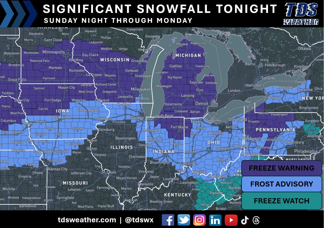
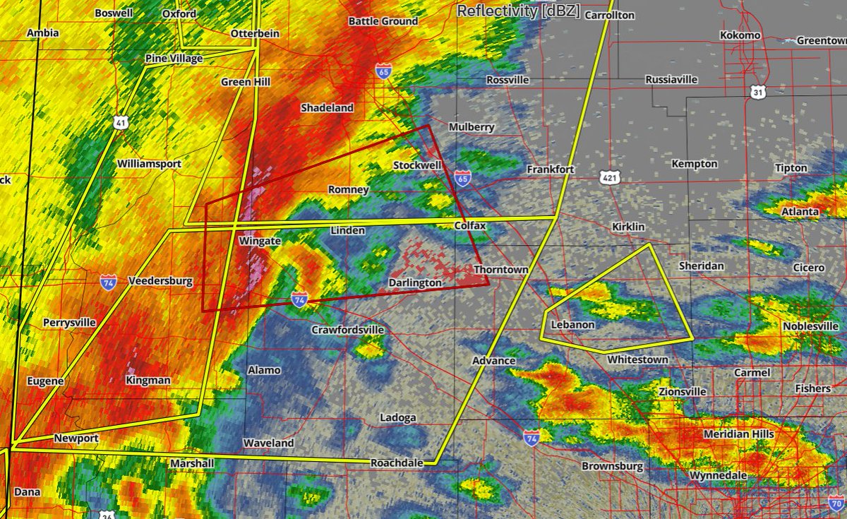
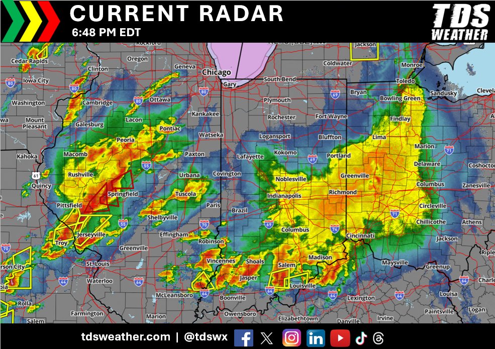
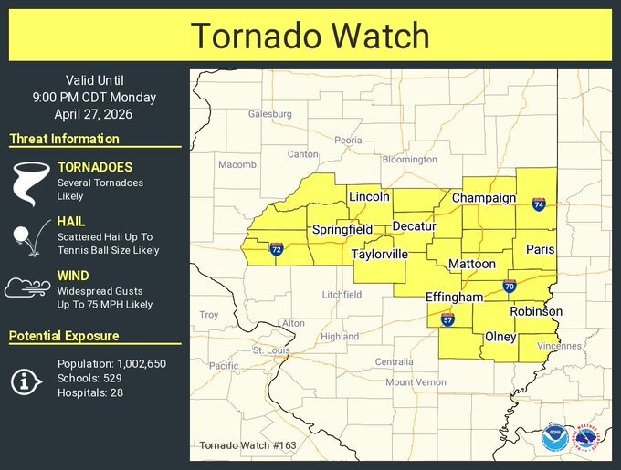
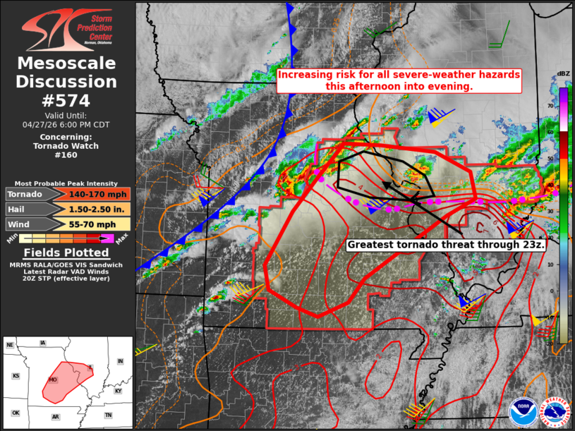
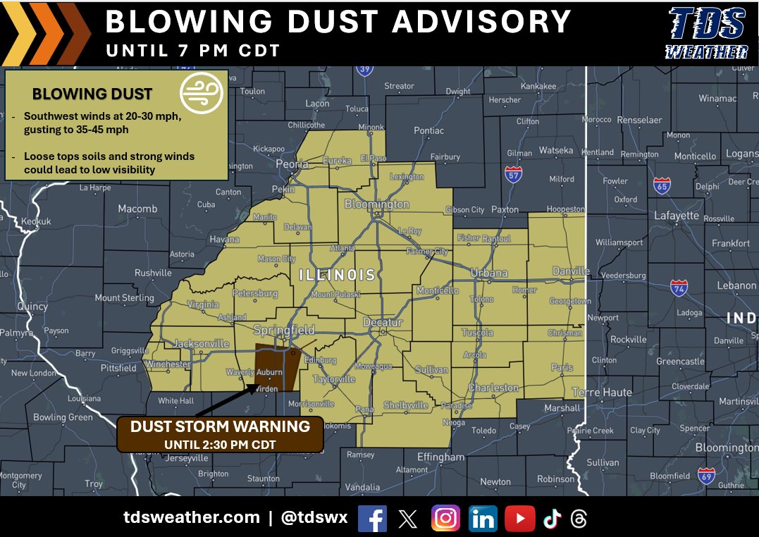
Blowing Dust Advisories and even a Dust Storm Warning has been issued across portions of central Illinois for this afternoon! Strong winds coupled with loose soils and agricultural activity are creating favorable conditions for blowing dust. This could reduce visibility to 0.25-1.00 mile, especially in rural areas! A Dust Storm Warning is in place through 2:30 PM CDT for Southwestern Sangamon County in central Illinois. Near zero visibility has been reported! Dust storms lead to dangerous driving conditions with visibility reduced to near zero. If driving, avoid dust storms if possible. If caught in one, pull off the road, turn off your lights and keep your foot off the brake. #ILwx
TDS Weather tweet media
English
1
4
6
692
TDS Weather
TDS Weather@TDSwx·
🥶 Widespread Freeze Warnings & Frost Advisories Tonight! A chilly night is ahead across the Midwest as temperatures take a sharp dip. Lows will fall into the 30s for much of the region, leading to widespread frost concerns. Meanwhile, the coldest air settles over the Great Lakes, where temperatures will plunge into the 20s by early morning. Be sure to protect sensitive plants and take precautions against the cold! #INwx #ILwx #OHwx #MIwx #WIwx
TDS Weather tweet mediaTDS Weather tweet media
English
0
3
9
1.2K
TDS Weather
TDS Weather@TDSwx·
FROST & FREEZE RISKS INTO THE WEEKEND ❄️ Below-average temperatures are settling in, bringing the potential for frost and freezing conditions over the next couple of nights. 🌙 Tonight: The greatest risk will be across the Great Lakes, where the coldest air is currently in place. Friday Night into Saturday Morning: Colder air pushes farther south, expanding the frost risk into central Indiana and surrounding areas. Sensitive vegetation may be at risk, be sure to take precautions if you’re in a frost-prone location! #ILwx #INwx #OHwx #MIwx #WIwx #AGwx #frost #freeze #plants
TDS Weather tweet mediaTDS Weather tweet media
English
0
4
17
2.6K
TDS Weather
TDS Weather@TDSwx·
WHO’S READY FOR SNOW ON MAY 1ST?! ❄️ Believe it or not, a touch of winter may try to sneak back in overnight. The HRRR continues to hint that a few wet snowflakes could mix in across northeastern Indiana after 2–3 AM. No accumulation is expected, but don’t be surprised if you catch a brief rain/snow mix from the pre-dawn hours into early Friday morning. A chilly start to May, that’s for sure! #INwx
TDS Weather tweet media
English
2
4
11
722
TDS Weather
TDS Weather@TDSwx·
Over the past 3 days, a widespread 2–4” of rain has fallen across parts of Illinois, Indiana, Ohio, and northern Kentucky. Locally higher around 6" were recorded in south-central Illinois and southern Indiana. These swaths of heavy rainfall led to flooding issues across portions of the Ohio Valley. #INwx #ILwx #OHwx #KYwx #MOwx
TDS Weather tweet media
English
0
3
13
746
TDS Weather
TDS Weather@TDSwx·
Tornado Warning National Weather Service Indianapolis IN 1112 PM EDT Mon Apr 27 2026 The National Weather Service in Indianapolis has issued a * Tornado Warning for... Central Monroe County in south central Indiana... Southeastern Owen County in west central Indiana... Northeastern Greene County in southwestern Indiana... * Until 1145 PM EDT. * At 1111 PM EDT, a severe thunderstorm capable of producing a tornado was located near Spencer, or 14 miles west of Bloomington, moving east at 40 mph. HAZARD...Tornado. SOURCE...Radar indicated rotation. #INwx
TDS Weather tweet media
English
0
0
2
1.5K
TDS Weather
TDS Weather@TDSwx·
Tornado Warning National Weather Service Indianapolis IN 1108 PM EDT Mon Apr 27 2026 The National Weather Service in Indianapolis has issued a * Tornado Warning for... Northern Shelby County in central Indiana... South central Hancock County in central Indiana... Northeastern Johnson County in central Indiana... Southeastern Marion County in central Indiana... * Until 1145 PM EDT. * At 1108 PM EDT, a severe thunderstorm capable of producing a tornado was located near Greenwood, or 13 miles southeast of Indianapolis, moving east at 60 mph. HAZARD...Tornado. #INwx
TDS Weather tweet media
English
0
1
3
1.4K
TDS Weather
TDS Weather@TDSwx·
The National Weather Service in Indianapolis has issued a * Tornado Warning for... Northeastern Morgan County in central Indiana... Northern Johnson County in central Indiana... Southeastern Hendricks County in central Indiana... Southern Marion County in central Indiana... * Until 1115 PM EDT. * At 1051 PM EDT, a severe thunderstorm capable of producing a tornado was located over Mooresville, or 14 miles southwest of Indianapolis, moving east at 55 mph. HAZARD...Tornado. #INwx
TDS Weather tweet media
English
0
0
1
3K
TDS Weather
TDS Weather@TDSwx·
Several Severe Thunderstorm Warnings are ongoing along the main line of storms from Indiana into southeastern Illinois. A few Tornado Warnings are still ongoing as well at 10:38 PM EDT. #INwx #ILwx
TDS Weather tweet media
English
0
1
3
688
TDS Weather
TDS Weather@TDSwx·
The National Weather Service in Indianapolis has issued a Tornado Warning for... East central Fountain County in west central Indiana... Southern Tippecanoe County in west central Indiana... Southwestern Clinton County in central Indiana... Northwestern Boone County in central Indiana... Northern Montgomery County in west central Indiana... * Until 1000 PM EDT. * At 926 PM EDT, a severe thunderstorm capable of producing a tornado was located 10 miles northeast of Veedersburg, or 14 miles northwest of Crawfordsville, moving east at 45 mph. HAZARD...Tornado. SOURCE...Radar indicated rotation. #INwx
TDS Weather tweet media
English
0
0
3
1.3K
TDS Weather
TDS Weather@TDSwx·
...TORNADO WARNING REMAINS IN EFFECT UNTIL 9 PM CDT FOR NORTHEASTERN CLINTON, SOUTHERN FAYETTE AND MARION COUNTIES IN SOUTH CENTRAL ILLINOIS... At 819 PM CDT, a confirmed and extremely dangerous tornado was located over Carlyle, moving east at 45 mph. This is a PARTICULARLY DANGEROUS SITUATION. TAKE COVER NOW! HAZARD...Damaging tornado and quarter size hail. SOURCE...Radar confirmed tornado. #ILwx
TDS Weather tweet media
English
0
2
5
1.9K
TDS Weather
TDS Weather@TDSwx·
A Severe Thunderstorm Watch for portions of Southern and Central Indiana, North-Central Kentucky, and Far Western Ohio until 4 AM EDT. Primary threats include... - Scattered damaging wind gusts to 70 mph possible - Scattered large hail events to 1.5" in diameter possible - A tornado or two possible #INwx #KYwx #OHwx
TDS Weather tweet media
English
0
2
4
590
TDS Weather
TDS Weather@TDSwx·
Severe weather continues across the region this evening. Several tornado warnings are ongoing across central Illinois. #ILwx #INwx
TDS Weather tweet media
English
0
0
2
578
TDS Weather أُعيد تغريده
NWS Lincoln IL
NWS Lincoln IL@NWSLincolnIL·
A new Tornado Watch #163 was issued to replace the previous tornado watch to clear up some technical issues with a merge of Severe Watch #158 and Tornado Watch #160. This watch is in effect until 9 pm CDT this evening. #ILwx
NWS Lincoln IL tweet media
English
0
4
12
1.3K
TDS Weather
TDS Weather@TDSwx·
A couple of mesoscale discussions across the region from the the SPC. One across Missouri into southwest Illinois for an increasing threat for all severe weather with the St. Louis area highlighted for the greatest tornado threat. Another mesoscale discussion is in place across southern IL, southwestern IN, and far northwestern KY for increasing strong to intense tornado potential. #ILwx #INwx #MOwx #KYwx
TDS Weather tweet mediaTDS Weather tweet media
English
0
1
7
1.4K
TDS Weather
TDS Weather@TDSwx·
A Particularly Dangerous Situation (PDS) Tornado Watch has been issued across portions of Northeast Arkansas, Southern Illinois, Southern Indiana, Western Kentucky, Southeast Missouri, Western Tennessee until 11 PM CDT. Primary threats include: - Several tornadoes and a few intense tornadoes likely - Scattered large hail likely with isolated very large hail events to 2.5" in diameter possible - Scattered damaging wind gusts to 70 mph likely #INwx #ILwx #MOwx #KYwx #TNwx #ARwx
TDS Weather tweet media
English
0
4
9
1.3K
TDS Weather أُعيد تغريده
NWS Paducah, KY
NWS Paducah, KY@NWSPaducah·
A tornado watch has been issued for parts of Arkansas, Illinois, Indiana, Kentucky, Missouri and Tennessee until 11 PM CDT
NWS Paducah, KY tweet media
English
1
27
47
6.8K
TDS Weather أُعيد تغريده
Joseph Cooper | TDS Weather
These last 2-3 runs of the HRRR really raise the concern level across the MOD risk area and even into southern IN. There's a lot of discrete to semi-discrete activity there. This would a be a bad scenario for a heightened tornado threat. #ILwx #INwx #MOwx
Joseph Cooper | TDS Weather tweet media
English
3
12
155
11K
TDS Weather
TDS Weather@TDSwx·
Several Severe Thunderstorm Warnings are in place across eastern Illinois and southwestern Indiana this afternoon. Both damaging and large hail have been reported. #ILwx #INwx
TDS Weather tweet media
English
0
0
7
607
TDS Weather
TDS Weather@TDSwx·
A TORNADO WATCH has been issued for southern Illinois and eastern/southern Missouri until 9 PM CDT. Primary threats include: - Several tornadoes and a couple intense tornadoes likely - Widespread damaging winds likely with isolated significant gust to 75 mph possible - Scattered large hail likely with isolated very large hail events to 2.5" in diameter possible #ILwx #MOwx
TDS Weather tweet media
English
0
0
8
631