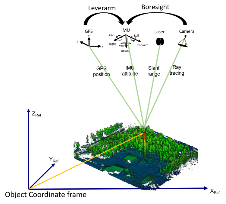
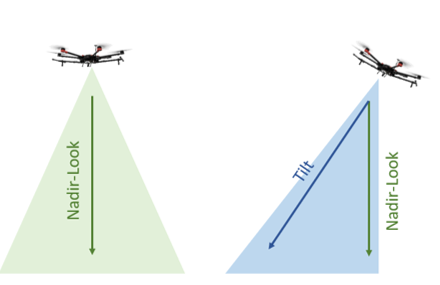
Geodetics

54 posts

Geodetics banner
Geodetics

Geodetics

@GeodeticsLiDAR

Geodetics is the go to provider for precision navigation and sensor integration for mobile applications in the air, on land and at sea.

San Diego, CA Beigetreten Ağustos 2017
47 Folgt89 Follower
Geodetics
Geodetics@GeodeticsLiDAR·
Check out this information session examining just a few of the many advanced applications utilizing our Geo-MMS product suite! Topics covered include Building Information Modeling (BIM), Security and Precision Agriculture. YouTube link - youtube.com/watch?v=hQo3Jo…
YouTube video
YouTube
English
0
1
0
0
Geodetics
Geodetics@GeodeticsLiDAR·
For their continued redevelopment, railway structural integrity must be assessed quantitatively. #LiDAR provides an excellent option for such assessment, due to its high scan rate, point measurement density and speed of data processing. buff.ly/31b3Ai8
Geodetics tweet media
English
0
0
0
0
Geodetics
Geodetics@GeodeticsLiDAR·
@geodetics_lidar and @VelodyneLidar share a long and fruitful partnership. Sensors such as the Velodyne VLP-16, HDL-32E and Puck 32MR are some of the most commonly implemented LiDAR sensors within the Geo-MMS product suite velodynelidar.com/success-storie…
Velodyne Lidar@VelodyneLidar

Did you know that unmanned aerial vehicles (UAV) can be used for detailed 3D mapping? @VelodyneLidar’s Puck helped @geodetics_lidar to create a high-quality and cost-effective UAV mapping solution that functions across various industries. Read more here: velodynelidar.com/success-storie…

English
0
0
2
0
Geodetics
Geodetics@GeodeticsLiDAR·
The uses and applications of classified LiDAR point clouds extends far and wide. Classified areas of forestry can be assessed over a given period of time. Learn what Geodetics products can do for your project...buff.ly/2LKhO0L #lidar #photogrammetry #drone #uavs
Geodetics tweet media
English
0
0
3
0