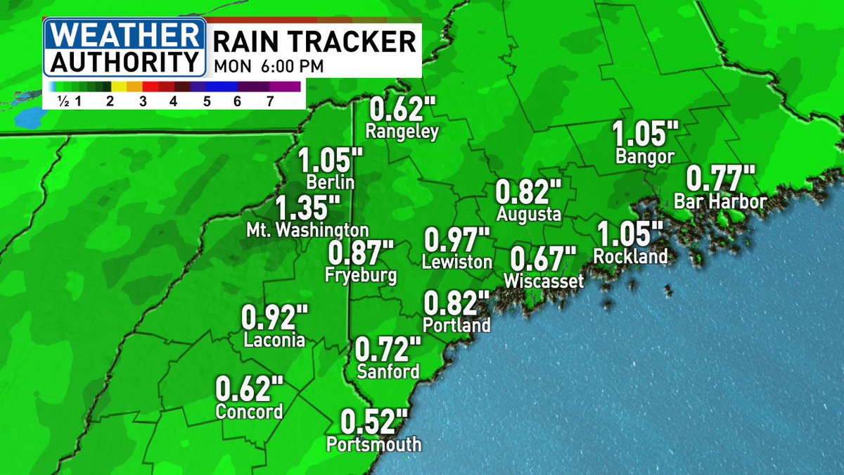
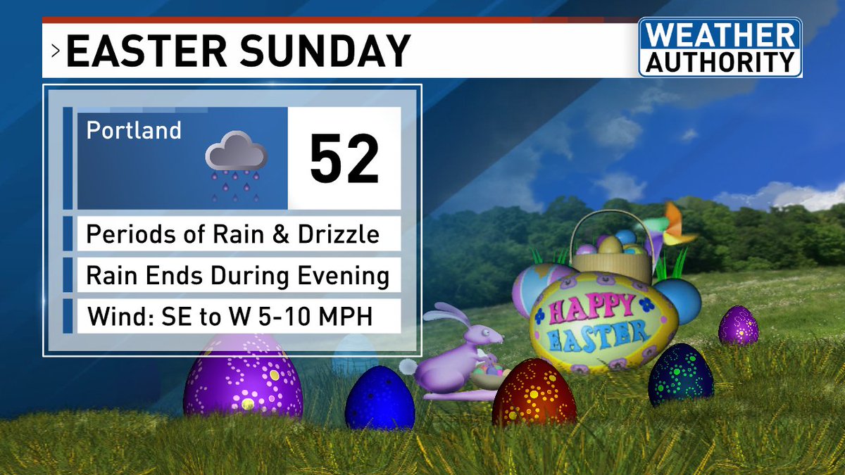
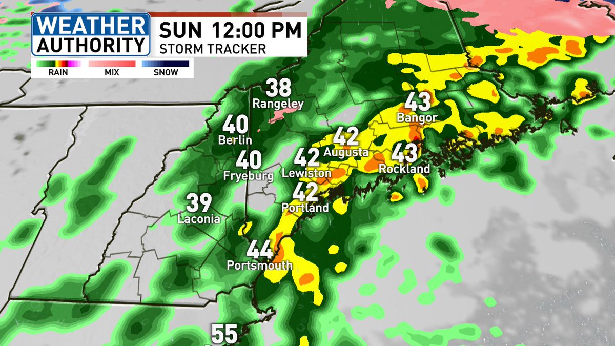
Areas of drizzle and showers will develop this evening and continue overnight. A steady round of rain, with pockets of heavy rain expected all day Thursday.
Many areas will pick up between 0.50"-1.50", however, there will be spots that see more than 2" by Thursday night.
A persistent afternoon sea breeze will keep the coastline cooler Sunday, Monday and Tuesday.
It looks like all three days, inland locales will easily make it into the 60s. The first 10-15 miles from the coast will struggle through the low to mid 50s.
Do you have plans late next week? The trends have brought in much cooler than average air Thursday through next weekend with 40s for highs.
To make it even worse, the likelihood we see a steady and potentially heavy rainfall late week is increasing. A multi-day event possible.
The dry stretch of weather will continue as we head through the weekend with seasonable temperatures.
While the winds will not be as strong as they were today, with the dry weather in place there will be a moderate, to at times high brush fire risk the next several days.
As expected, the rain has flipped to snow in the mountains and foothills. It's even coating up the ground in spots!
The rain and snow will come to an end from 7-10 PM tonight from west to east.
This is a rain event for much of the region on Sunday. However, some wet snow is expected across the north and mountains.
Wet snowflakes may mix in further south as the precipitation comes to an end Sunday evening.
...And no, your eyes are not playing tricks on you. Some snow is possible in the foothills and mountains. As the cold air wraps in behind the front and the precip is coming to an end, wet snowflakes may mix in further south. Little to no accumulation is expected.
A very wet and rainy Sunday on tap. Many areas will see between a 0.50"-1.00" of rainfall. Any outdoor plans, it may be a good idea to bring the umbrella and rain coat.
Another blast of chilly air moves in next week with a frost and freeze expected, potentially multiple nights.
Here's a look at the forecasted overnight lows. Monday night into Tuesday morning looks like the coldest with low to mid 20s likely, and teens in the mountains.
Okay... this is just ridiculous. Once again a front is dividing mid-Summer heat in southern New England with a cool, Spring-like feel in Maine. Only 43 degrees in Bar Harbor as of 1:00 PM.
The strongest storms will be off to our west and these storms will likely weaken as then approach a much more stable airmass in Maine. But stay tuned to the radar after 5:00 PM as a few of these storms may make it into western and southern Maine. (2/2)
Expect lots of clouds, cool temperatures, occasional showers or drizzle through this afternoon. We're watching this evening for heavier downpours and a thunderstorm threat. (1/2)
If you're looking for the sunshine on Sunday, head outside early. Clouds will increase throughout the day with temps only near 50. There will be a breeze, but not nearly as strong as today.
Classic spring in Maine. A southerly wind on Friday will keep the coast, in particular the Midcoast, much chillier than areas inland. 60s to near 70 degrees possible well away from the coast.
Happy Easter everybody! I hope you we're able to enjoy this day, even if it was indoors.
4:00 PM Radar update: Rain is coming to an end across the north. It will slowly end 4-7 PM from west to east this evening, and expected some clearing skies tonight.
I wish I had better news about our Easter Sunday forecast, but it looks like periods of rain are expected throughout the day. Some morning freezing rain possible in the mountains before transitioning to plain rain.