
Dadicke
64.7K posts

Dadicke
@Dadicke
Auch wenn sie öffentlich sind, bleiben die Tweets, Kommentare und Retweets meine private Meinung
Se unió Mart 2020
161 Siguiendo178 Seguidores
Klaudia Tanner@tannerklaudia
Nach der heutigen Videokonferenz der europäischen Truppensteller zur Friedensmission @UNIFIL_ im Libanon, die unter der Führung der französischen Verteidigungsministerin @CaVautrin heute stattgefunden hat, ist jedenfalls klar: Wir stehen zusammen. Die Angriffe auf Blauhelmsoldaten, die für den Frieden im Einsatz stehen, sind aufs Schärfste zu verurteilen. Unsere Gedanken sind bei den gefallenen indonesischen Soldaten und ihren Familien. Österreich steht weiterhin zu seiner Verantwortung im Rahmen der UNIFIL-Mission im Libanon. Gleichzeitig haben der Schutz und die Sicherheit unserer rund 170 Soldatinnen und Soldaten oberste Priorität! Das habe ich auch heute klar zum Ausdruck gebracht! Gerade in herausfordernden Zeiten ist die enge Abstimmung zwischen den Partnerstaaten entscheidend, um weiterhin den Schutz im Einsatzraum Libanon gewährleisten zu können. #unifil #bundesheer #friedensmission #sicherheit (BM) 📸HBF/Carina Karlovits
QHT
👇‼️
OccupytheWeb@three_cube
Check this out! This is important! Bluetooth is powerful and ubiquitous technology. Unfortunately, it has many weaknesses and flaws. Check out this new article on the WhisperPair. It enables hackers to track your position by forcing pairing through the Fast Pair access. Bluetooth vulnerability, which allows hackers to hijack your Bluetooth sessions and track you on the map. In addition, we showed how Bluehood Scanner works to reconstruct behavioral patterns hackers-arise.com/bluetooth-hack… @three_cube
QST
Dadicke retuiteado

Gestern konnte die Zielfahndung des LKA Wien einen 29-Jährigen mit ukrainischem Haftbefehl in einer Wohnung in Wien-Leopoldstadt lokalisieren und mit Unterstützung der WEGA sowie der PDHE festnehmen.
Näheres in den #Presseaussendungen ⬇️
polizei.gv.at/wien/presse/au…

Deutsch
Dadicke retuiteado
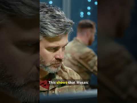
Das neue Video von AUSTRIA ARMS beschäftigt sich mit der AK Plattform und wird von Elvis, einem Ex-SOF, präsentiert.
spartanat.com/de/die-verbess…
Deutsch
Dadicke retuiteado
Dadicke retuiteado

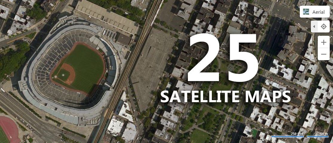
🛰 OSINT Resource: Compare Satellite Images Without Wasting Hours
Most people use Google Maps for satellite imagery but it barely scratches the surface for real investigations 😈
When I’m working on OSINT cases involving locations, this is one of my favorite resources to quickly compare satellite images over time.
This curated list includes 25 proven satellite imagery services that go far beyond simple map viewing 🛰️
You can use them to analyze:
🏗 Building development over time
🔥 Consequences of incidents and disasters
🛣 Infrastructure changes
🕵️ Activity patterns in specific locations
Real-life OSINT example 👇
I used these services to compare satellite images of the same site across different years, which helped confirm when construction actually started, contradicting the public timeline shared online.
Perfect for:
✅ Geolocation
✅ Conflict and incident analysis
✅ Infrastructure OSINT
✅ Environmental monitoring
🔗 Resource link: gisgeography.com/satellite-maps/
__________
P.S. ♻️ Repost if you found this helpful.
If you liked this post and would like to learn more methods and techniques to discover information about people, check out my OSINT Mastery course cybersudo.org/osint-mastery
English
#Bundesheer
yeah, Rasta mann, rastamann...
Michael Bauer@Bundesheerbauer
Der Verfassungsgerichtshof hat das für Soldaten geltende Zopf-Verbot gekippt. Da es Soldatinnen sehr wohl erlaubt ist, einen Pferdeschwanz zu tragen, sehen die Höchstrichter eine "Benachteiligung auf Grund des Geschlechts". Zudem erkannte der VfGH eine Verletzung des Rechts auf Privatleben. Die entsprechende Verordnung ist daher "unverzüglich" aufzuheben.
IS
#Bundesheer 👇‼️🤔
FalconFeeds.io@FalconFeedsio
The Iran-Israel-US conflict just gave us the world's first AI-native information war. And we weren't ready. Our latest report at FalconFeeds tracked what happened after Operation Epic Fury launched on February 28, 2026. Within hours, social media was flooded with AI-generated deepfakes, manipulated satellite imagery, and recycled footage - all designed to shape perception before the truth could catch up. The scale is staggering: → 110+ unique AI deepfakes pushing pro-Iran narratives identified in just two weeks (NYT) → Hundreds of millions of views on fabricated content (BBC Verify) → A single individual in Pakistan ran 31 hacked X accounts posting AI-generated war footage - motivated not by ideology, but by platform revenue sharing → Google's own AI search validated a fake "CIA outpost destroyed in Dubai" claim using footage from a 2015 residential fire → Netanyahu was forced to release proof-of-life videos after deepfake speculation spiraled globally What's new isn't wartime propaganda - it's three compounding factors: 1. Technical barriers to hyper-realistic fabrication have effectively disappeared 2. Platform economics financially reward viral misinformation at the individual creator level 3. AI verification tools didn't just fail to help - they became amplification vectors Russia and China amplified Iranian AI content without needing coordination. A shared anti-Western interest created organic alignment. Video game footage was passed off as combat. State media used AI-altered satellite imagery to fabricate strike successes. The cognitive battlespace is no longer secondary. It's where legitimacy, morale, and public consent are won and lost. The full open-source intelligence report covers documented cases, actor mapping, narrative propagation timelines, platform failures, and geopolitical consequences. We need to talk about this - because the next conflict will be worse. #AIWarfare #Deepfakes #InformationOperations #OSINT #Geopolitics #Misinformation #NationalSecurity #FalconFeeds
Dadicke retuiteado


Dadicke retuiteado

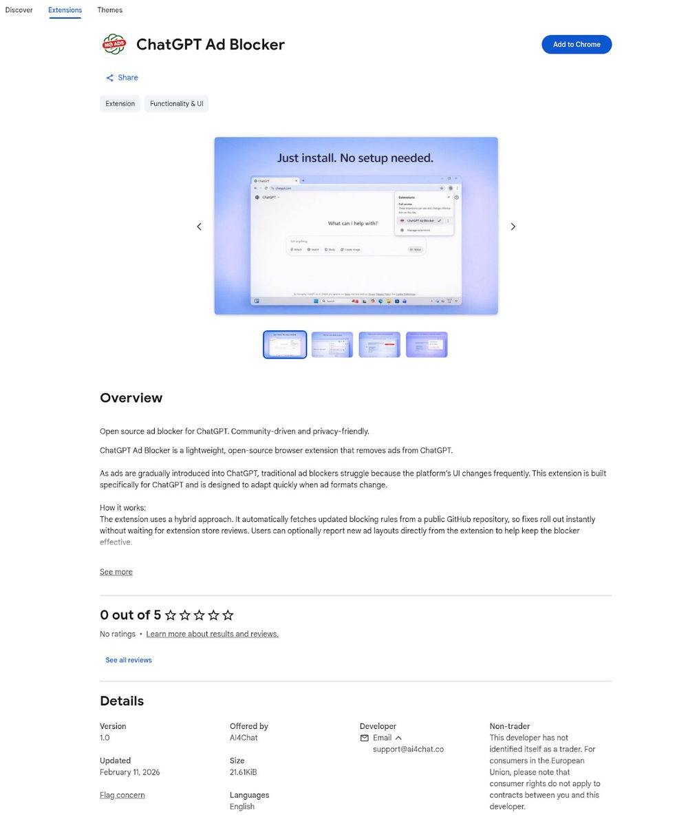
DomainTools unmasks a malicious "ChatGPT Ad Blocker" Chrome extension that steals private conversations and sends them to Discord. Check your extensions now!
#ChatGPT #OpenAI #CyberSecurity #InfoSec #Malware #Privacy #AIBot #DataLeak #ChromeExtension
securityonline.info/chatgpt-ad-blo…
English
Thx4posting
IISS News@IISS_org
Militaries across the Middle East are investing heavily in artificial-intelligence-enabled military technologies. Israel is the most advanced regional player in this area, deploying AI weapons systems; intelligence, surveillance and reconnaissance; and decision-support systems in combat across the region. Turkiye has also developed several AI military systems, while the United Arab Emirates is investing in international arms manufacturers with a view to later indigenising this technology. Explore the latest #ChartingMiddleEast analysis by Noor Hammad: go.iiss.org/47Bz0zy
English
Dadicke retuiteado

Die koordinierte Abschaltung von #Aisuru und #Kimwolf durch das ZAC NRW, das BKA sowie kanadische und US-amerikanische Behörden am 19. März 2026 verdient echte Anerkennung. it-daily.net/it-sicherheit/…
Deutsch
Dadicke retuiteado
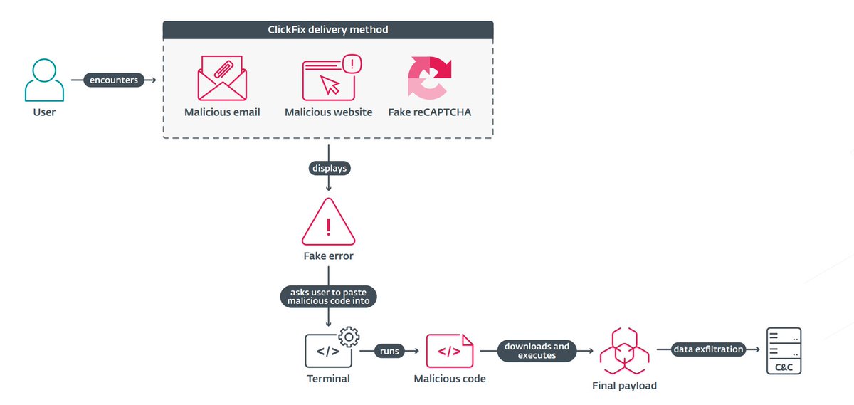
DeepLoad malware uses AI-generated code and ClickFix tactics to steal credentials. Learn how it hides in LockAppHost.exe and survives even after a full cleanup.
#DeepLoad #CyberSecurity #AI #Infosec #MalwareAnalysis #ClickFix #ReliaQuest #FilelessMalware
meterpreter.org/the-invisible-…
English
Dadicke retuiteado

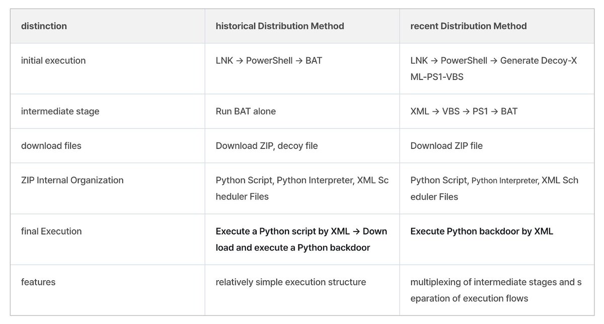
ASEC reports that Kimsuky has changed how it distributes malicious LNK files. While the end goal remains the same - execution of a Python-based backdoor or downloader - the group has reworked the intermediate stage into a more complex multi-step chain. asec.ahnlab.com/en/93151/
English
Dadicke retuiteado
Apple releases iOS 18.7.7 to combat the "DarkSword" exploit kit. Protect your legacy iPhone or iPad from this state-level threat by updating today.
#AppleSecurity #iOS1877 #DarkSword #iPhoneUpdate #CyberSecurity #Infosec #TechNews #iPadOS #SecurityAlert
securityonline.info/apple-ios-18-7…

English