RyanWeather.Com

141.5K posts

RyanWeather.Com banner
RyanWeather.Com

RyanWeather.Com

@Ryan541

Southern Oregon and Northern California weather updates. My website links to weather data live from Medford, Oregon. Hourly weather updates 24/7/365.

Medford, Oregon Se unió Nisan 2009
128 Siguiendo2.2K Seguidores
RyanWeather.Com
RyanWeather.Com@Ryan541·
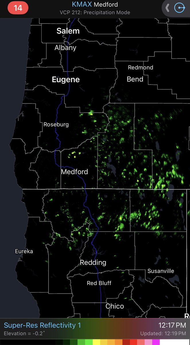
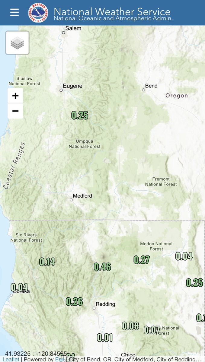
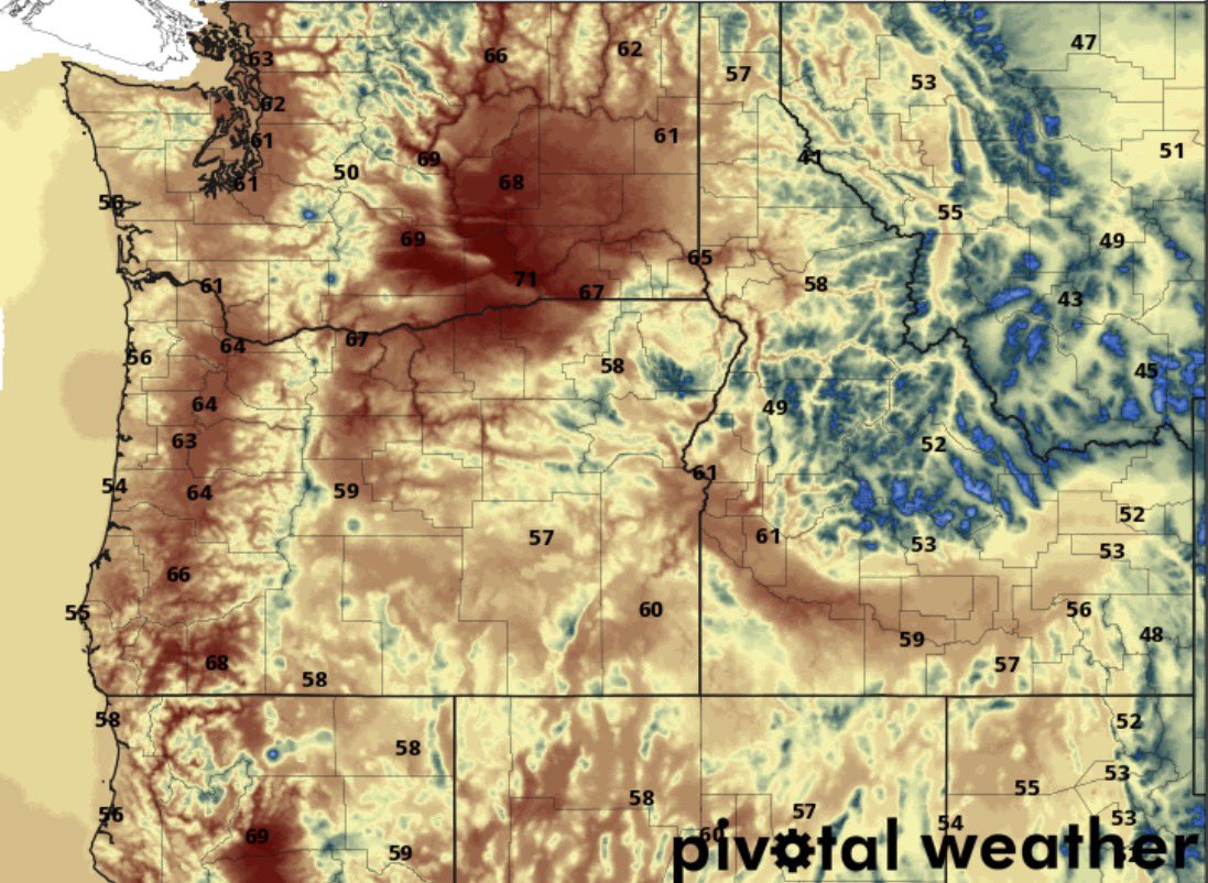
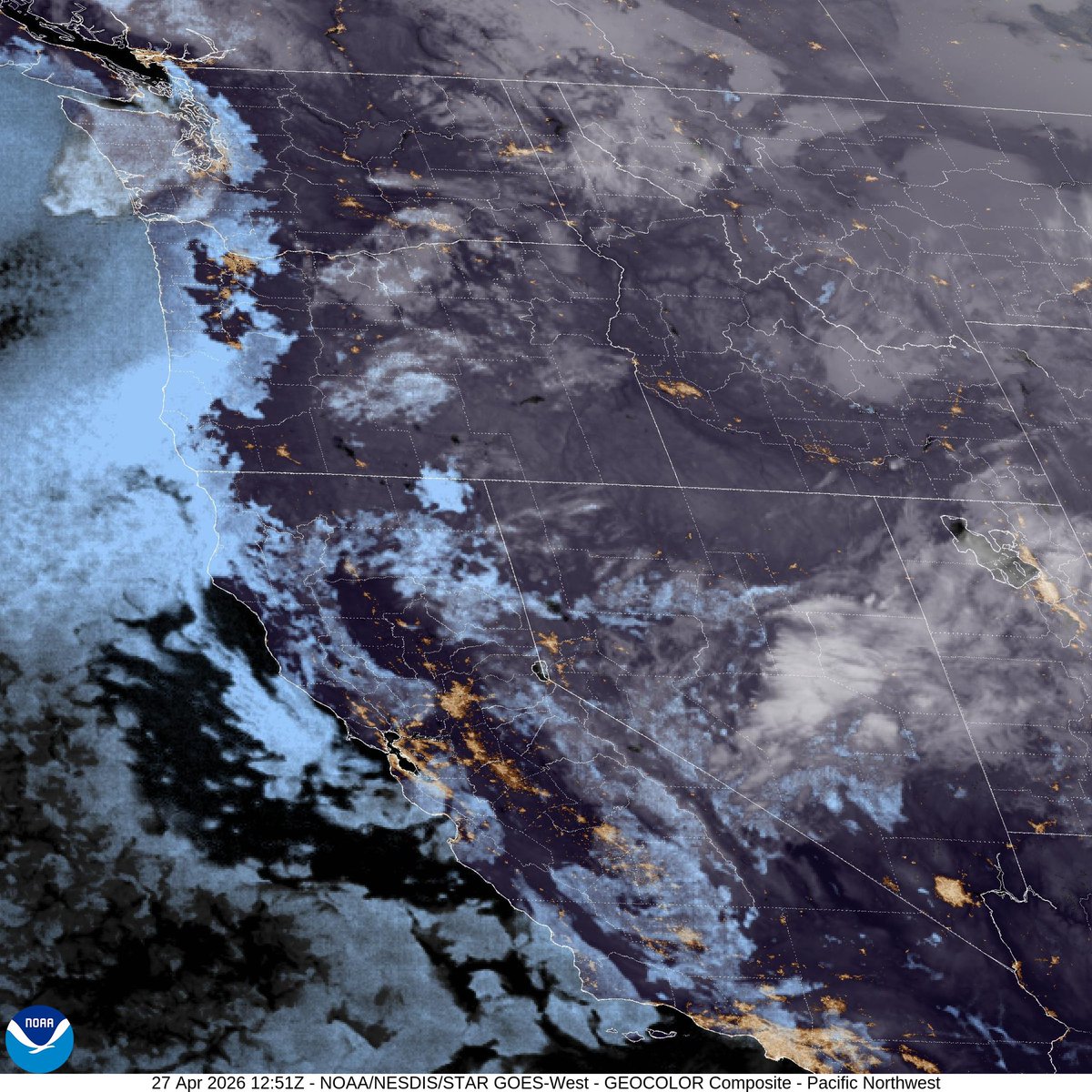
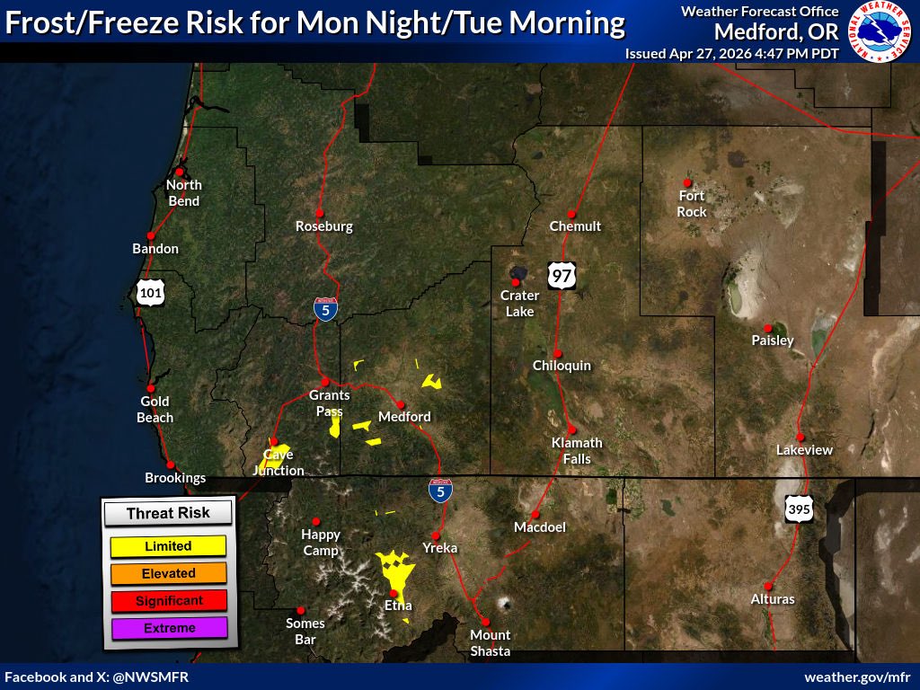
Another cooler night with mostly clear skies in place. We could see isolated pockets of frost develop early tomorrow morning in some of the western interior valleys.
RyanWeather.Com tweet mediaRyanWeather.Com tweet media
English
0
1
5
59
RyanWeather.Com
RyanWeather.Com@Ryan541·
Much less shower activity today as the trough is gradually weakening across the region. There has been more activity focused in Northern California, where showers have been observed off and on.
RyanWeather.Com tweet media
English
0
1
5
54
RyanWeather.Com
RyanWeather.Com@Ryan541·
Radar returns are picking up on a few showers still developing this afternoon. An isolated thunderstorm could develop through later this evening. Most of the activity looks to be focused across Northern California.
RyanWeather.Com tweet media
English
0
2
7
64
RyanWeather.Com
RyanWeather.Com@Ryan541·
48 hour observed precipitation amounts show where showers and thunderstorms have been focused across the region.
RyanWeather.Com tweet media
English
0
2
6
56
RyanWeather.Com
RyanWeather.Com@Ryan541·
The latest 6-10 day temperature and precipitation outlooks from the Climate Prediction Center at NOAA shows a return of above normal temperatures and a trend toward below normal precipitation chances. This is from the 2nd-6th of May.
RyanWeather.Com tweet mediaRyanWeather.Com tweet media
English
0
3
11
75
RyanWeather.Com
RyanWeather.Com@Ryan541·
It is a colder start to the morning across the region. We did see lows as forecast drop into the 30’s west of the Cascades. A few isolated areas of frost are possible early today before we warm up.
RyanWeather.Com tweet media
English
0
2
9
59
RyanWeather.Com
RyanWeather.Com@Ryan541·
High temperatures today will be trending near normal for most areas. Here are the latest GFS model projected highs across the region.
RyanWeather.Com tweet media
English
0
2
10
65
RyanWeather.Com
RyanWeather.Com@Ryan541·
Visible satellite imagery this morning shows plenty of lower level clouds across portions of the coast and extending into the western interior valleys. A few higher level clouds are also streaming overhead.
RyanWeather.Com tweet media
English
0
2
6
67
RyanWeather.Com
RyanWeather.Com@Ryan541·
With a trough overhead and clear skies for most locations, we could see temperatures drop into the 30’s west of the Cascades. If you have frost sensitive plants you will want to protect them from damage.
RyanWeather.Com tweet media
English
0
2
6
79
RyanWeather.Com
RyanWeather.Com@Ryan541·
Thunderstorms are active again this afternoon across Siskiyou and Modoc counties. Here is a look at radar returns and lightning strikes recorded in the last 20-60 minutes.
RyanWeather.Com tweet mediaRyanWeather.Com tweet media
English
0
1
5
163
RyanWeather.Com
RyanWeather.Com@Ryan541·
The HRRR model composite reflectivity this morning is indicating we could see an isolated showers to develop over eastern Curry/western Josephine County later this afternoon. The rest of the potential for thunderstorms will be across Siskiyou, Modoc, Klamath and Lake counties.
RyanWeather.Com tweet media
English
0
1
6
109
RyanWeather.Com
RyanWeather.Com@Ryan541·
A beautiful morning in the Rogue Valley from the Phoenix, OR webcam. Higher level clouds are streaming overhead across the region today.
RyanWeather.Com tweet media
English
0
2
6
73
RyanWeather.Com
RyanWeather.Com@Ryan541·
The 80’s look to make a return as we head into late next week. Here is a look at the projected highs across the region on Thursday.
RyanWeather.Com tweet media
English
0
2
8
118
RyanWeather.Com
RyanWeather.Com@Ryan541·
The 48 hour accumulated precipitation estimates shows where showers and thunderstorms are most likely to produce measurable rainfall through 5 AM Tuesday.
RyanWeather.Com tweet media
English
0
2
4
63
RyanWeather.Com
RyanWeather.Com@Ryan541·
The Storm Prediction Center at NOAA does show thunderstorm potential continuing again today across portions of Siskiyou, Modoc, Klamath and Lake counties later this afternoon and evening. Similar to yesterday these will isolated to scattered in nature.
RyanWeather.Com tweet media
English
0
1
3
70
RyanWeather.Com
RyanWeather.Com@Ryan541·
High temperatures today will cool a few degrees in response to the weak trough overhead. Here are the current GFS model temperatures outlooks across the region.
RyanWeather.Com tweet media
English
0
2
3
71
RyanWeather.Com
RyanWeather.Com@Ryan541·
Satellite imagery this morning shows where the fog and low clouds are positioned along the coast. This has extended inland across some of the western interior valleys. Areas of clouds are also in place across Northern California and east of the Cascades.
RyanWeather.Com tweet media
English
0
2
10
96
RyanWeather.Com
RyanWeather.Com@Ryan541·
The snow is melting off quickly along the caldera walls at Crater Lake. You can see this quite well on the Sinnott Overlook webcam this evening.
RyanWeather.Com tweet media
English
0
2
8
129
RyanWeather.Com
RyanWeather.Com@Ryan541·
The latest 8-14 day temperature and precipitation outlooks from the Climate Prediction Center indicate we will trend toward above normal temperatures and near to below normal precipitation heading into the first full week of May.
RyanWeather.Com tweet mediaRyanWeather.Com tweet media
English
0
2
7
89
RyanWeather.Com
RyanWeather.Com@Ryan541·
A few active thunderstorms are developing in Modoc County. Here is a look at the radar returns and the recorded lightning strikes in the last 20-30 minutes.
RyanWeather.Com tweet mediaRyanWeather.Com tweet media
English
0
1
2
63