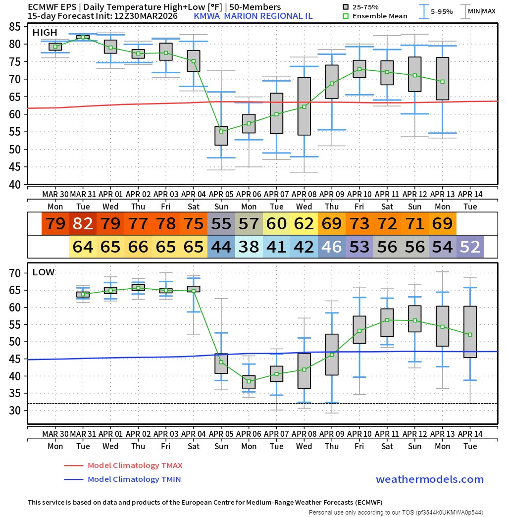
Jim Rasor
11.2K posts

Jim Rasor
@Forecaster
FXing for SIL since 1987. Went to college to learn how to help farmers find better weather info. Still pursuing that goal. WKU UNCA
Carterville, IL Inscrit le Aralık 2008
491 Abonnements5.6K Abonnés

1 hour rainfall projection for Thursday evening (Apr16) presenting another hit/miss scenario with potential for some storms to produce more than 2" of rain over parts of SIL while nearby neighbors see much less. Very high lightning numbers appear in data but limited signs of organized severe weather.
Multiple rounds of storms are projected for SIL/SIN/WKY Thursday. Severe risk locally is small but not 0. Keeping up with your chosen short term forecast source will be important.

English

Cold front passing through early brings elevated chance of showers early (sunrise) with isolated LIGHT showers possible all day. Biggest chance and heaviest rain early, less than 1/4" total. Winds shifting from the NW (mostly tailwind) 10-15mph gusting higher than 20. Temperatures near 60 in the morning dipping into 50s as front goes past then moving slowly to around 60 by afternoon.
English

@Forecaster Jim, what are your early thoughts on Saturday for the River to River Relay?
English

I was asked yesterday about chatter from others about frost in the projected upcoming cold snap. Using the coldest in the likely range Monday morning (Apr20) we see 39ish and the coldest possible in this projection at 36ish. Surface frost, especially if there is some residual moisture from weekend showers seems very possible but I see no indication of 32- and damage to early plantings. We will once again lose some soil temperature however.

English

I started doing seasonal outlooks for farm groups in January. The message was very similar through the most resent presentation.
Wet March, which verified, but was concentrated in a couple heavy events and surrounded by dry.
Wet April, as the detail evolved this outlook was based on a wet week 3 following a dry week 2. I have posted latest outlook for week 3.
Some moisture in May but with very little consistency in outlooks. This continues for lower Ohio River valley but is starting to lean wet.
Jun-July-Aug dry. This outlook is not consistent with recent data leaning June to the wet side.
Transition to ElNino will come with instability in flow but once it is established I anticipate dry conditions for an extended period. That has looked focused in July and August but is losing consistency in projections.
I am interested to see if a very strong ElNino shifts southern jet north and creates some large late summer events for us. Not a prediction from me but a recognition that I see the possibility.
Bottom line, I have been reading data for months leading me to believe week 3 of April will be wetter than normal which equates to more than 1.25" in 7 days.

English

Looking for duration of dry skies and next rain chance projection. The signal of isolated light rain showers is worth skipping over in my way of reading this data. The average solution of .20 at Apr13 is overwhelmed by more than half the solutions to that point being lighter than .10 and some at 0. I focus on the event around Apr15-16 when making my outdoor chore plans.
Dry days for now to take advantage of expecting rain in week 2 of outlook.

English

The measure in this gauge puts my spot at the average of projections for this event and there are still showers to move through. It is already more green than it was. Some is the washing of dust off but this rain was an important recharge for a lot of vegetation. Cool dry period projected to be with us for several days with next rain event consistently projected around next weekend (Apr10-12).

English

The wet, the dry and the return to wet. Looking at the forest and not getting hung up on trees, wet through Apr4, dry Apr5-Apr11 then wet again. Each wet period looks significant in this data. Even the driest solution lines are roughly 1" an event. I focus on the dry days for scheduling chores. We need the rain but need work days to utilize the rain.

English

I have waited a couple days to post waiting on consistency in projections. April is still delivered as overall wetter than normal but a dry period arrived in solutions several days ago and was an inconsistent intermittent solution. The dry period is still in this round for parts of my home region focused in this week 1 projection with week 2 wet area wide.
Rain probability and quantity solutions peak Saturday (Apr4) with a cool/dry period following for a few days.
Week 2 and 3 lean wet with some inconsistency.
May numbers continue to display small swings around normal.
My take is some field days will exist in April and May with a turn to dry solution late May and persisting in general through August.

English

Unsettled weather with a south flow moving into lower Ohio River valley this week culminates with wet flow from Gulf on Saturday (Apr4) projected to bring heaviest widespread rain. Dry air pushing the front is significant and projected to persist for much of the following week.
Wet April outlooks still have some merit but granular look suggests it could be similar to March and come in large events with dry spells in between. This solution aligns with at least one other I have looked at that brings a dry week 2 (Apr7-13) to the region.

English

45 day rainfall projection delivers a wet solution, especially from Apr6 through May6. Looking at more than the average solution highlighted with a number, when we look at probable range of solutions the driest number for the 45 days is greater than 6" and the wettest is greater than 10". A pattern shift is still in the charts and it shifts to a wet flow for the lower Ohio River valley.
Couple dry days left to take advantage of.

English

@Forecaster Every time we get closer to a wetter period it gets drier and drier with the event…..March 29th, 0.8”➡️0.30”➡️0.1”. April 1st 1.2”➡️1.0”➡️0.5”.


English

My gauge had 0.01" this morning, more miss than hit. Apr1 looks like a switch flips in projections. I realize there have been some recent showers but the overall dry period we are in is about to end. I see some going to the fields. This dry spell is projected to end in a few days. After that, every outlook I see for my region is wet through April. Some sign of drier in May. Signals of DRY in Jun-Jly-Aug.

English

The first 2 weeks of March brought more rain to my gauge than I measured in Dec-Jan-Feb combined. There are 2 statements in that statistic. The most recent 10 days have brought no measurable rain to my gauge.
Every projection I have cited recently for spring planning presentations has delivered a wet outlook for April. This map projection for Apr1 presents a defined flow of moisture from the Gulf into the lower Ohio River valley. All the numbers I read are wet and this map breaks down some of the why and how behind the how much.

English


