Lees Summit Police retweeté
Lees Summit Police
2.3K posts

Lees Summit Police
@LSPDPIO
Public Information Unit -- Lee's Summit MO Police Department This account is not monitored 24 hours a day, if you have an emergency, call 911 or 816-969-7390 #7
Lee's Summit, MO Inscrit le Ağustos 2013
229 Abonnements5.8K Abonnés


Lees Summit Police retweeté
Lees Summit Police retweeté
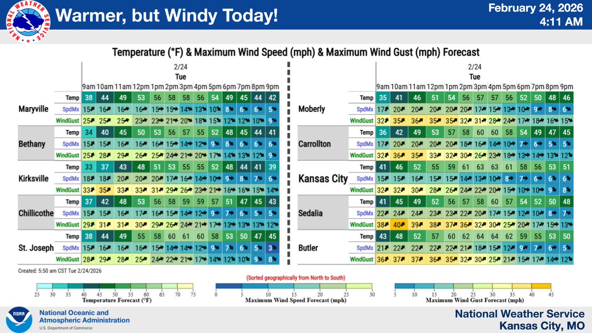
After a break from the heat today - Tuesday, well-above-normal temperatures return Wednesday - Thursday, before trending cooler for the weekend.

English
Lees Summit Police retweeté

Lees Summit Police retweeté

Lees Summit Police retweeté
Much above average temperatures return to the region today and continue through Saturday, with record high temperatures likely Friday. A cold front is expected to move through the region on Sunday, with temperatures returning closer to seasonal norms Monday.

English
Lees Summit Police retweeté
Lees Summit Police retweeté

Lees Summit Police retweeté

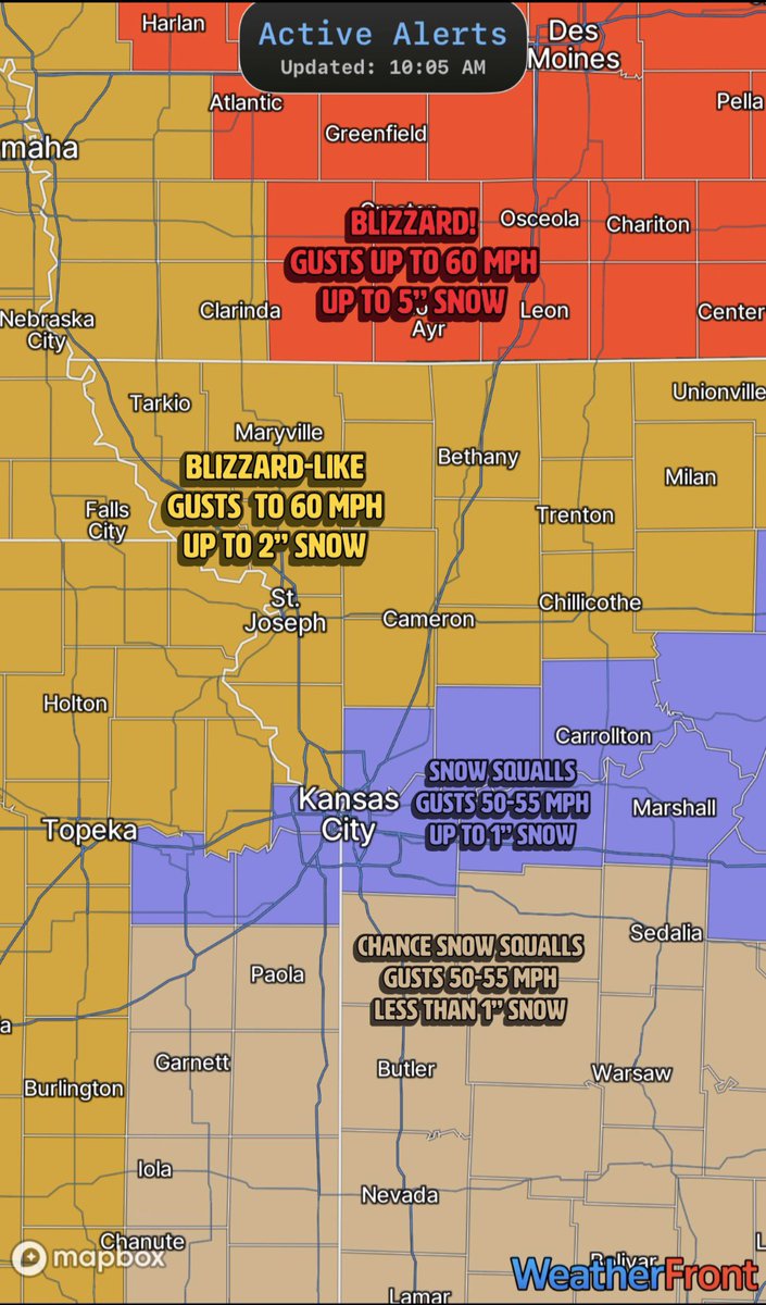
🌬️ ❄️ Here it comes! Temperatures will start dropping like a rock. A cold front is cutting through Kansas City, and gusts behind the front are already exceeding 50 mph. Snow squalls are possible between 2 PM and 9 PM. Gusts of 50 to 60 mph during this time could greatly reduce visibility and significantly impact travel in areas of falling snow. Total snowfall amounts—which will be difficult to measure due to the powerful winds—will range from a dusting up to 2 inches. Higher amounts of snow are expected north of Kansas City, with amounts tapering off south of Interstate-70.
Posted at 10:30 AM, Sunday, March 15, 2026.
English
Lees Summit Police retweeté
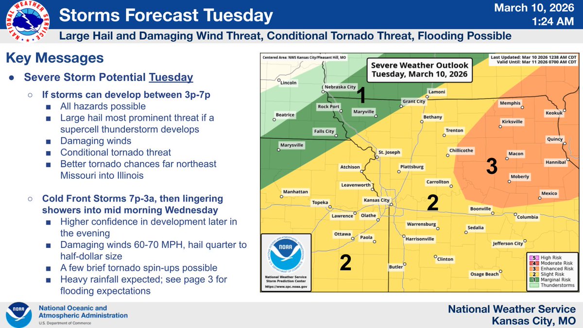
Severe storms are expected this evening. Expect storms to develop between 6 and 8pm with higher chances after 8pm. Large hail and damaging winds will be possible. Tornado threat remains low. Severe storms move out by 1am with lingering showers and storms into the early morning.

English
Lees Summit Police retweeté
Very warm today at the start. Strong to severe storms possible later this evening, along with some areas of flooding. Remain weather aware late this afternoon and through the overnight hours.
English
Lees Summit Police retweeté

Lees Summit Police retweeté
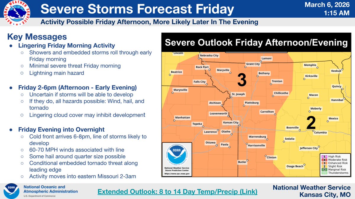
Showers/storms will continue through most of the morning. There is potential for a few severe storms Friday afternoon, depending on how quickly morning activity diminishes. A line of storms is expected later Friday evening which may become severe.
English
Lees Summit Police retweeté
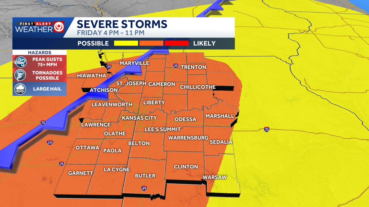
❗Certain severe weather hazards are becoming more apparent for Friday, especially between 7 PM and 11 PM. Here’s your Thursday morning severe weather update.
💨 Damaging wind gusts are likely with the strongest thunderstorms, not all the thunderstorms, with the potential for peak gusts greater than 75 mph.
🌪️ QLCS tornadoes are possible along a fast-moving line of thunderstorms during the evening and early night. QLCS tornadoes typically develop quickly, are short-lived, move fast, and are rain-wrapped. They are difficult to warn for because they can develop, cause damage, and dissipate within a scan or two of the radar—another reason to act quickly if a warning is issued for your community.
⛈️ There is a conditional risk for a few severe thunderstorms to develop late in the day between 4 PM and 7 PM, but it depends heavily on the atmosphere recovering from morning showers and non-severe thunderstorms, as well as overcoming a cap (a layer of warmer air aloft). If thunderstorms do develop during this window and take advantage of building instability and wind shear, they will likely become severe and capable of all types of severe weather.
💭 There are still many uncertainties, including scenarios where the atmosphere gets worked over by morning storms and later-day/evening thunderstorms never reach their peak potential.
✅🏠📱 Continue to check the forecast twice daily for updates, review your severe weather safety plan, and have multiple ways to receive weather alerts, such as the KMBC app and a NOAA Weather Radio.
English
Lees Summit Police retweeté
Areas of dense fog will continue this morning before the focus turns to multiple rounds of thunderstorms over the next two days. Friday afternoon/evening has the highest potential for severe hazards with damaging winds, large hail, and isolated tornadoes all possible.

English
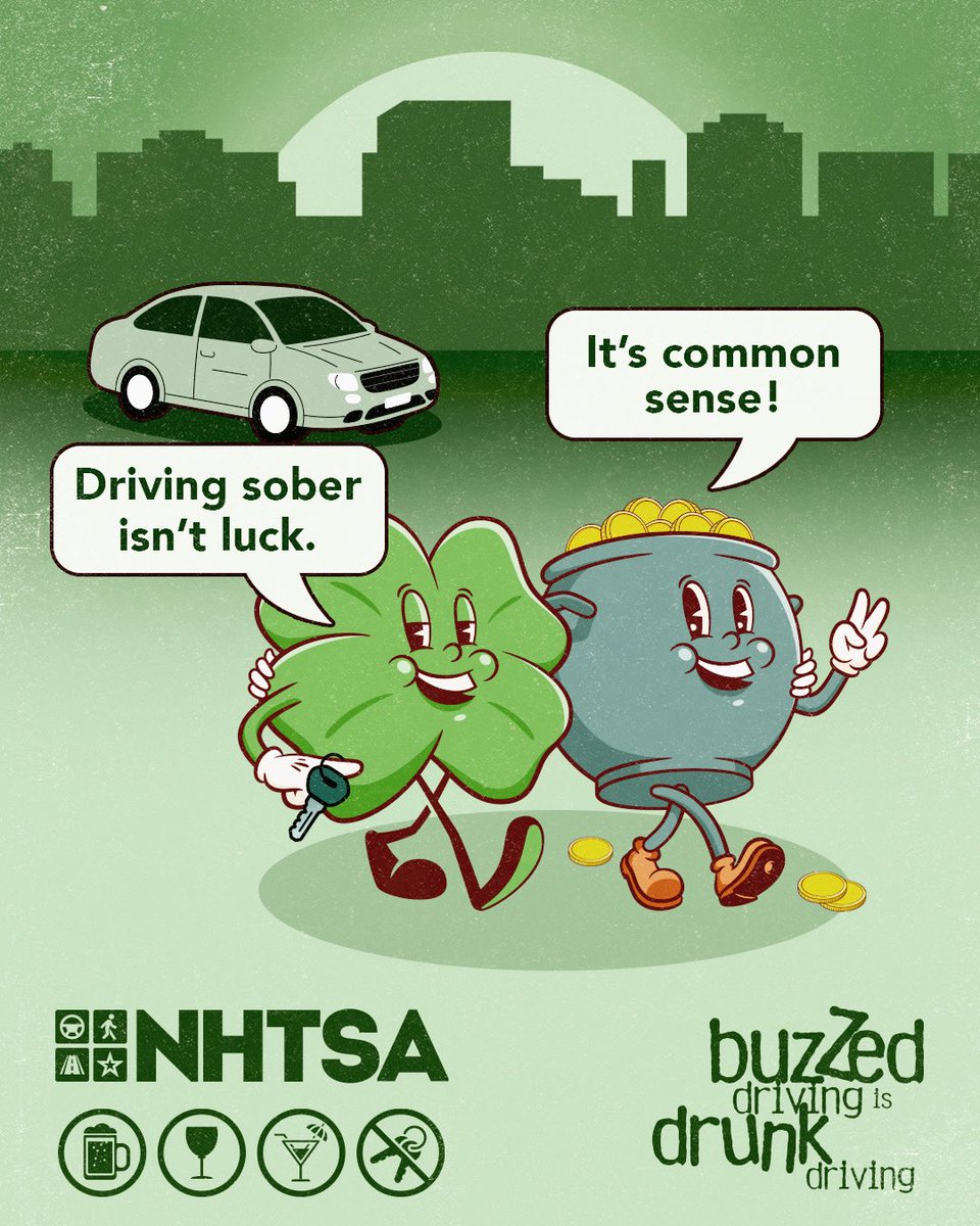
Missouri is about to do its things and show you all the seasons in just a few days! Guess that why we call it the 'Show Me' State.
NWS Kansas City@NWSKansasCity
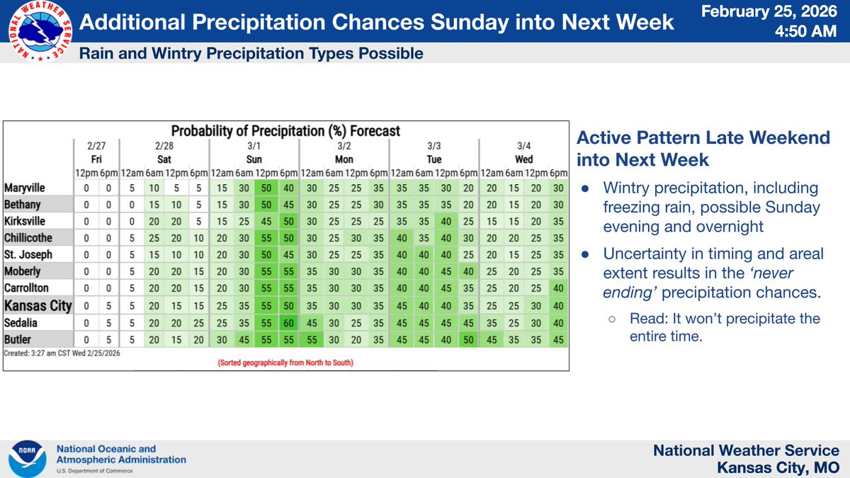
Very warm and dry conditions with highs in the 70s will lead to high fire danger today and a Red Flag Warning is in effect from 1PM-6PM. Wintry precip is expected on Sunday. Rain is expected across central MO, with a transition zone of mixed precip near I-70, light snow north.
English
Lees Summit Police retweeté

Lees Summit Police retweeté
The warmer temps have arrived and stick around through the week. What about precip?
𝗧𝗼𝗻𝗶𝗴𝗵𝘁: Light rain for most. Light rain/snow mix or freezing drizzle possible near Iowa border.
𝗦𝘂𝗻𝗱𝗮𝘆 𝗣𝗠/𝗼𝘃𝗲𝗿𝗻𝗶𝗴𝗵𝘁: Keep an eye here as various winter precip possible.

English
Lees Summit Police retweeté