
Cynoptec
16K posts
Cynoptec
@Cynoptec
Creator of proprietary long-range methods 🌦 Weather: Long Range Forecasting 📈 Markets: Bitcoin • Metals •
Australia शामिल हुए Aralık 2011
469 फ़ॉलोइंग6K फ़ॉलोवर्स

@Cynoptec We had falls of 40mm to 70mm + in southern Victoria, it has been perfect, 7C here and very cold but the ground is still warm enough for grass to grow, just
English
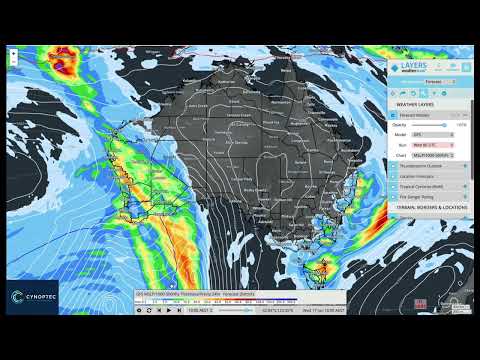
The recent 48-hour satellite loop highlights the clearing trend across southeastern Australia as the High Energy Period (27 May – 3 June) draws to a close.
This weather phase delivered widespread rainfall from southwest Western Australia through South Australia and across large parts of the southeast, including much-needed falls in drier areas of northeast New South Wales and southeast Queensland.
As the departing low pressure system moves away from the southeast, a dominant ridge of high pressure is establishing across much of the nation. This will promote generally cool, settled conditions, along with strengthening trade winds along the eastern coastline.
Attention now turns to the next phase of activity.
Renewed frontal systems are expected to affect southwest Western Australia and agricultural regions from around 8 June, while cloudband activity is forecast to increase toward mid-month across parts of the southern interior.
The next significant national weather periods remain on track for mid June and again during the third quarter of July.
Long-range forecasts are available now and currently extend through to December 2026.
ozindustriesforecasting.com
Know the Future™
English
Crypto – Interesting Signals Are Forming and Should Not Be Ignored
The chart shown is the weekly XRP timeframe.
Take note of the current price action and compare it with the equivalent phase of the previous cycle.
Price continues to trend lower in the short term, yet several factors are beginning to stand out:
• XRP is approaching a significant long-term trend support region.
• RSI remains within a historical support zone.
• Early signs of bullish divergence are beginning to emerge.
• Similar conditions developed prior to the last major upside expansion.
Should this divergence confirm over the coming weeks, it may signal that the next phase of the altcoin market is approaching sooner rather than later.
Historically, major altcoin moves have not occurred in isolation. If capital begins rotating back into the broader market, it could suggest that Bitcoin and the wider cryptocurrency sector are also preparing for their next advance.
Nothing is confirmed yet, but the signals developing beneath the surface deserve close attention.
A detailed member update will be released in the coming days as conditions continue to evolve and the technical picture becomes clearer.
The biggest opportunities are often identified during periods of uncertainty, not after the headlines arrive.
Now is the time to begin preparing for what could become the next major multi-year cycle.
For detailed market analysis and forecasts:
ozindustriesforecasting.com
Know the Future™

English
Oz Industries Forecasting is now CYNOPTEC.
→ New name. New website. A brand new in-house long-range model, never done before. Launching soon.
→ The high energy period clears the southeast over the next 24 to 48 hours, with frost building and snow on the Alps.
→ A front rolls into southwest WA around the 8th, Kalbarri to Esperance.
→ Showers and storms fire through the NSW interior, northern Vic and southern QLD midweek.
→ The big one: a major cloudband cycle builds from the 16th to 17th, Pilbara and Gascoyne through the interior, possibly running into week four.
An active June is ahead.
Full breakdown in today's update 👇
youtu.be/gQN3Y03omBI
Know the Future™
YouTube
English
THE WINTER SOLSTICE ARRIVES ON 21 JUNE 2026 AT 6:24:13 PM AEST.
This marks the exact moment the Sun enters 0° Cancer and the Southern Hemisphere reaches its shortest day and longest night of the year.
At the solstice, the Earth is tilted approximately 23.5° on its axis, placing the Southern Hemisphere at its maximum angle away from the Sun. This reduces the amount of solar energy reaching our part of the world, resulting in shorter daylight hours and the cooler conditions associated with winter.
Importantly, the seasons are not caused by how close the Earth is to the Sun. They are driven by Earth's axial tilt and the changing angle at which sunlight reaches the planet throughout the year.
From this point onward, daylight hours will gradually increase as Australia begins its slow journey back towards spring and eventually the summer solstice in December.
The solstice has held deep significance for cultures throughout history. Ancient civilisations carefully observed the Sun's movements, using solstices to track the seasons, guide agricultural activities, and mark important ceremonial and spiritual events. Monuments such as Stonehenge in England and Newgrange in Ireland were constructed with remarkable alignments to the solstices, reflecting humanity's long-standing connection with the cycles of the heavens.
More than just a date on the calendar, the solstice is a reminder that our seasons are governed by predictable astronomical cycles that have shaped life on Earth for thousands of years.
Winter begins.
The days slowly grow longer.
Life goes on....


English
The Market Moves in Asset Classes.
One of the most common questions I receive after posting about Bitcoin is:
"What about Altcoin X?"
"What about Coin Y?"
"What about Coin Z?"
The reality is that most investors spend too much time looking at individual trees and not enough time looking at the forest.
Markets tend to move together within their broader asset class.
• Crypto assets often follow the same underlying cycle. Bitcoin, Ethereum and many altcoins may differ in volatility, but the broader trend is frequently driven by the same liquidity, sentiment and capital flow dynamics.
• Precious metals such as gold and silver often move in their own cycle.
• Equity markets also tend to move as a group, whether that is the Australian market, the US market or specific sectors within them.
The chart below compares Bitcoin and Ethereum over multiple years.
Different assets.
Different percentages.
Different headlines.
Yet the broader structure remains remarkably similar.
This is why it is important to zoom out.
If you can identify the major cycle, you often gain insight into the direction of the wider asset class.
Many traders become trapped chasing the next hot coin, stock or commodity.
The bigger opportunity is understanding the environment those assets are operating within.
Learn to read the cycle.
Learn to identify the trend.
Learn to zoom out.
The market often becomes much clearer when you stop focusing on the noise and start focusing on the structure.
#Bitcoin #Ethereum #Crypto #Investing #Trading #Markets #Gold #Silver #Stocks #Cycles #MarketAnalysis #KnowTheFutureTM

English
THE NEXT MAJOR NATIONAL WEATHER EVENT IS NOW APPROACHING.
From around mid June, attention turns to a significant reactivation of Australia's northwest cloudband pattern as deep tropical moisture becomes entrained into the upper atmosphere.
Our long-range forecasts indicate a stronger northwest cloudband developing during the second half of June, with rainfall spreading through parts of Western Australia, the Northern Territory, Queensland and sections of the southern interior.
At the same time, a coastal trough is expected to increase rainfall potential across northeastern Queensland.
This event is then forecast to be reinforced during late June, with persistent cloudband activity maintaining rainfall across inland districts while a series of cold fronts continue to impact southern Australia.
The result is a broad-scale national weather event capable of delivering widespread winter rainfall and continuing the active moisture corridor pattern that has been a recurring feature throughout 2026.
This is one of the key weather periods highlighted in our long-range forecasts months in advance.
For detailed timelines, rainfall maps, district forecasts and ongoing updates, visit:
ozindustriesforecasting.com/post/june-2026…
Know the Future™
English
Satellite and water vapour imagery continues to capture the progression of the powerful southern low pressure system responsible for severe weather impacts across parts of Western Australia, South Australia, Victoria and New South Wales.
The system has generated widespread damaging winds, hazardous coastal conditions, heavy showers and significant weather warnings as it tracks eastwards across southern Australia.
Severe Weather Warnings remain active across multiple states and are being updated regularly.
For the latest official warnings and alerts, visit:
bom.gov.au/weather-and-cl…
Know the Future™
English
Cynoptec रीट्वीट किया

The largest #tornado in recorded History happened on this day, 13 years ago, in El Reno, Oklahoma.
This video shows the #Dominator 2 surging east for intercept of this 2.5 mile wide tornado, and we ran into a power line and launched the hood into the tornado.
Very sadly, my friend and mentor, Tim Samaras and the TWISTEX team with Carl Young and Paul Samaras lost their lives to this tornado while doing ground-breaking science.
RIP TWISTEX
English
Cynoptec रीट्वीट किया
We're flying through space right now!
The sensation of static is deceptive. Our planet is hurtling through space at incredible speed: rotating on its axis, orbiting the Sun, and all of this, together with the Solar System, is moving around the center of the Milky Way.
English
SUPER EL NIÑO.
DROUGHT.
WILDFIRES.
HOTTEST EVER.
The headlines change, but the script often remains the same.
Back in 2023, the narrative was dominated by warnings of a "Super El Niño", unprecedented heat and widespread drought.
Yet for many regions, the atmosphere had other ideas.
Fast forward to November 2026.
The words being used today may be different, but the pattern feels strangely familiar.
November is shaping as a month of extremes.
Heat.
Humidity.
Severe thunderstorms.
Heavy rainfall.
Flash flooding.
Giant hail.
And periods where conditions may change dramatically over relatively short distances.
The challenge is not identifying that severe weather may occur. The challenge is understanding where, when and how those atmospheric energies evolve into real-world outcomes.
That is where broad climate narratives often fall short.
The atmosphere rarely follows headlines.
It follows physics.
It follows cycles.
And sometimes, if you listen carefully enough, history leaves clues.
As Dorothea Mackellar famously wrote:
"I love a sunburnt country,
A land of sweeping plains,
Of ragged mountain ranges,
Of droughts and flooding rains."
November 2026 appears set to remind Australia once again of that final line.
Know the Future™


English
THE HIGH ENERGY PERIOD HAS PEAKED — and the south is wearing it.
Gusts to 135 km/h at Cape Naturaliste. A deep Southern Ocean low. Severe weather warnings stretching from WA all the way to Tasmania. And finally — the season's FIRST true frontal rain. 👀
This isn't another northwest cloud band, folks. This one's coming in from the west, and it changes WHO gets the rain.
Here's what the next few days hold 👇
✅ Deep low tracking across SA → Victoria → Tasmania
✅ Damaging winds + abnormally high tides along the south
✅ Possible blizzard conditions across the Alps Tuesday — the first real snow dump of the year
✅ Frontal rain finally favouring the southeast, Riverina & southern slopes
✅ Northern interior districts? Probably sitting this one out
Then it dries out... before a STRONGER signal builds off the west coast mid-month.
📍 "My place didn't get any rain!" — and 10 km away they copped 30 mm. It comes down to ONE thing: the direction a system comes from. Get that right and you'll know who wins and who sits in the rain shadow — every time.
That's exactly what today's member update is built on — full district-level outlook, the mid-month western signal, the end-of-month system, AND the extended view out to late July.
📄 Read the written forecast:
ozindustriesforecasting.com/post/frontal-r…
Don't guess the weather. Know the Future™ 🌏
English
THE HIGH ENERGY PERIOD HAS PEAKED — and the south is wearing it.
Gusts to 135 km/h at Cape Naturaliste. A deep Southern Ocean low. Severe weather warnings stretching from WA all the way to Tasmania. And finally — the season's FIRST true frontal rain.
This isn't another northwest cloud band, folks. This one's coming in from the west, and it changes WHO gets the rain.
Here's what the next few days hold 👇
✅ Deep low tracking across SA → Victoria → Tasmania
✅ Damaging winds + abnormally high tides along the south
✅ Possible blizzard conditions across the Alps Tuesday — the first real snow dump of the year
✅ Frontal rain finally favouring the southeast, Riverina & southern slopes
✅ Northern interior districts? Probably sitting this one out
Then it dries out... before a STRONGER signal builds off the west coast mid-month.
"My place didn't get any rain!" — and 10 km away they copped 30 mm.
It comes down to ONE thing: the direction a system comes from. Get that right and you'll know who wins and who sits in the rain shadow — every time.
That's exactly what today's member update is built on — full district-level outlook, the mid-month western signal, the end-of-month system, AND the extended view out to late July.
📄 Read the written forecast: ozindustriesforecasting.com/post/frontal-r…
📝 Register here: ozindustriesforecasting.com/membership
Don't guess the weather. Know the Future™ 🌏

English
Cynoptec रीट्वीट किया

The 975 hPa low pressure system affecting southern WA on Sunday.
English
Cynoptec रीट्वीट किया
The central pressure of the low affecting southern WA plummeted from 1003 to 976 hPa in the 24 hours to 8am AWST on Sunday.
English
Cynoptec रीट्वीट किया

🌀 The 2026 hurricane season officially begins on Monday. Here's my top-level discussion on what to expect throughout the season and over the next couple weeks.
English
SEVERE WEATHER ALERT | SOUTHWEST WA
A significant weather event is now unfolding across Western Australia, with a powerful cold front and deepening low pressure system set to impact the South West Land Division through Sunday and Monday.
Damaging to locally destructive wind gusts exceeding 125 km/h are possible, particularly across coastal and exposed areas from the Central West through Perth, the Southwest and South Coast districts.
Heavy rainfall may also trigger localised flash flooding, while dangerous marine conditions, damaging surf and abnormally high tides develop along large sections of the WA coastline.
Impacts include:
• Damaging to locally destructive winds
• Heavy rainfall and flash flooding
• Dangerous surf and coastal erosion
• Abnormally high tides and possible coastal inundation
• Hazardous marine conditions with gale-force winds
• Sheep graziers warning for exposed livestock
Locations of concern include Perth, Geraldton, Bunbury, Mandurah, Margaret River, Albany, Esperance, Katanning, Northam, Merredin and surrounding districts.
This marks the first of three major weather features identified in our long range forecasts, with additional significant periods currently highlighted around 27–29 June and again during 27–29 August.
Members have been tracking these major weather periods months in advance through our long range forecasting service extending out to November 2026.
Know the Future™
English
@JH_Otway_Ranges ENSO - completely misinterpreted by most with minimal influence on weather systems.
English
@OzIndustries All we are hearing is a supper El Nino, some are saying if it happens it doesn't always mean drought anyway
English
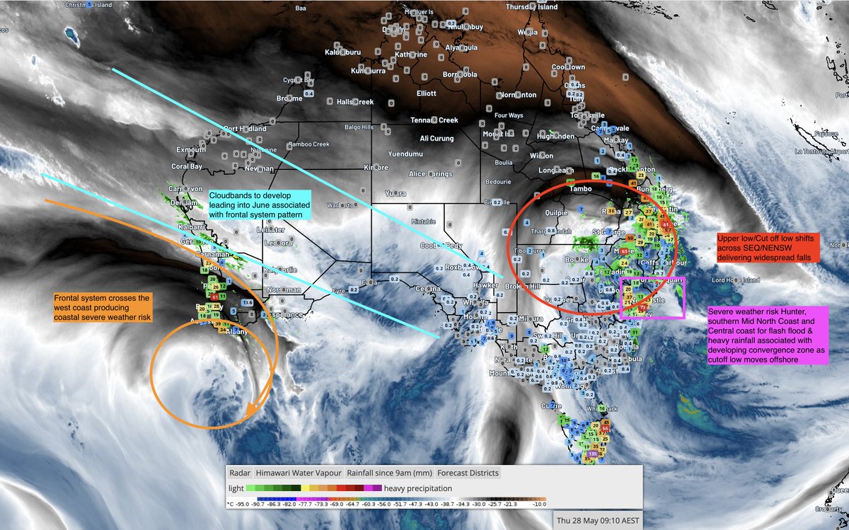
🌧️ DROUGHT BREAKER UNDERWAY
Widespread rain has swept SA, VIC, TAS, NSW and QLD — and WA storms are next.
The 27.MAY -3.JUNE High Energy Period is delivering exactly where the ag zones need it, with a genuine drought breaker shaping up for deficits that have persisted for months.
Today's update breaks down exactly where the rain is falling, the heavy rainfall watch for the Hunter & Mid-North Coast (100-200mm possible overnight), WA's incoming damaging winds and 65–70kt gusts, plus the full June outlook state by state — and a model breakdown so you know what to actually trust.
Read the full article here 👉 ozindustriesforecasting.com/post/high-ener…
Want your region covered in detail?
Tonight's live webinar includes region-specific Q&A — free for Gold members & Weather Pro subscribers, just $10 for general entry. Grab your ticket on the website before it kicks off.
ozindustriesforecasting.com/event-list
Know the Future™
English