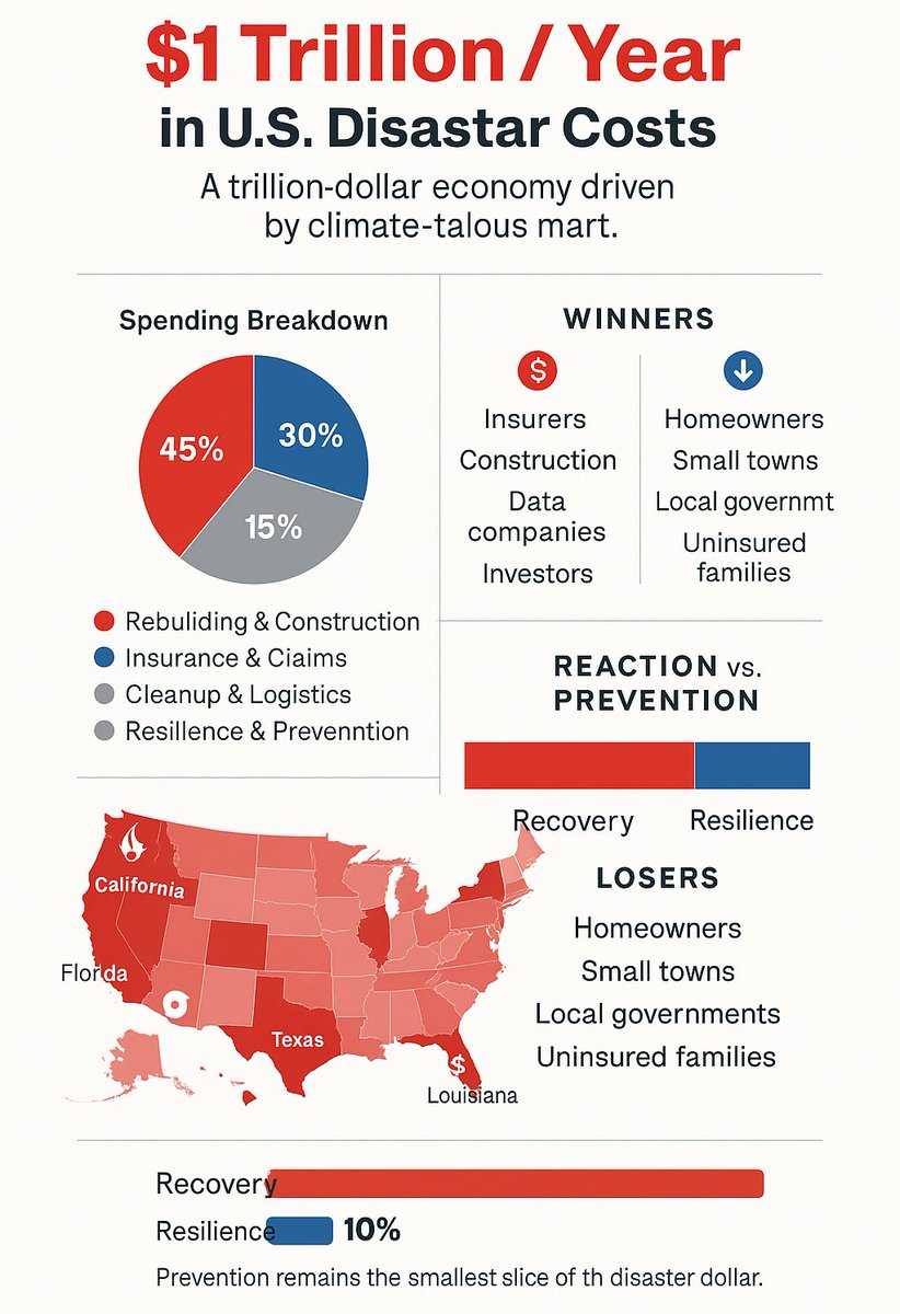
Disaster Relief Maps

3K posts

Disaster Relief Maps banner
Disaster Relief Maps

Disaster Relief Maps

@disastermapping

Map of Natural Disasters: #Fire, #Flood, #Hurricane, #Tornado, #Earthquake #Volcano #Tsunami Operated by @SyndicatedMaps

Los Angeles Bergabung Eylül 2017
563 Mengikuti193 Pengikut
Disaster Relief Maps me-retweet
DeadZones.com
DeadZones.com@DeadZones·
"He is charged with starting a fire on Jan. 1," Acting U.S. Attorney Bill Essayli said. "It did take a week to reignite, but he is charged with starting the Palisades Fire." deadzones.com/2025/10/if-pal…
DeadZones.com tweet media
English
0
2
3
88
Disaster Relief Maps me-retweet
R A W S A L E R T S
R A W S A L E R T S@rawsalerts·
🚨#BREAKING: Officials with the National Weather Service have confirmed the nation’s first EF-5 tornado in over a decade. 📌#Enderlin | #NorthDakota Officials with the National Weather Service have confirmed the nation’s first EF-5 tornado in more than a decade. After 4,414 days, the NWS has officially upgraded the June 20, 2025, Enderlin, North Dakota tornado to an extremely powerful EF-5, the highest classification on the Enhanced Fujita Scale, with estimated wind speeds exceeding 200+ mph. And resulting in three lives. This marks the first EF-5 tornado since the catastrophic Moore, Oklahoma storm on May 20, 2013, which was more than a mile wide and claimed 24 lives The announcement has stunned meteorologists nationwide, with experts calling the Enderlin tornado one of the strongest ever recorded across the Northern Plains.
English
1K
6.2K
51.4K
4.3M
Weather Track US
Weather Track US@weathertrackus·
What a year it has been! This is the highest risk in the CONUS that has been issued by the SPC so far this year (Valid Sep 19). What was your highest risk in 2025 (so far)?
Weather Track US tweet media
English
71
69
526
43.3K
Disaster Relief Maps me-retweet
Steve Lookner
Steve Lookner@lookner·
Tsunami wave of 3.6 feet observed in Crescent City, California, and 3.0 feet observed in Arena Cove, California (from NWS)
Steve Lookner tweet media
English
12
73
237
28.8K
Disaster Relief Maps me-retweet
Steve Lookner
Steve Lookner@lookner·
Some west coast US tsunami measurements (so far), from National Weather Service
Steve Lookner tweet media
English
6
24
116
18.8K
Disaster Relief Maps me-retweet
Michael Ferragamo
Michael Ferragamo@FerragamoWx·
Something very rare is about occur in the Pacific Ocean. In just a few hours, a tsunami will be passing right underneath a major hurricane. Can’t recall ever seeing this before.
Michael Ferragamo tweet media
English
390
4.8K
24.6K
2.4M
Disaster Relief Maps me-retweet
Steve Lookner
Steve Lookner@lookner·
Some new Hawaii tsunami measurements from National Weather Service, a 4-foot wave has been reported (some other places here as well)
Steve Lookner tweet media
English
24
108
319
55.6K
Donald J. Trump
Donald J. Trump@realDonaldTrump·
Due to a massive earthquake that occurred in the Pacific Ocean, a Tsunami Warning is in effect for those living in Hawaii. A Tsunami Watch is in effect for Alaska and the Pacific Coast of the United States. Japan is also in the way. Please visit tsunami.gov for the latest information. STAY STRONG AND STAY SAFE!
English
61.9K
61.3K
447.5K
81.5M
Disaster Relief Maps
Disaster Relief Maps@disastermapping·
High tide at 7pm in Hawaii does help either
Disaster Relief Maps tweet media
English
0
0
0
40