
MEAA MEDIA CONSULT
25 posts
MEAA MEDIA CONSULT
@MeaaMedia
An emerging media consultancy firm gradually developing as a center of excellence in Nigeria for public relation, advertisement, MC and web content management
Ibadan, Nigeria 가입일 Ocak 2019
37 팔로잉15 팔로워


@brucemarchiano Thank you so much sir. Watching you act as Jesus was a real and big blessing to me. God bless you more. Amen.
English
It is a fact that GIS is more than just software. People and methods are combined with geospatial software and tools, to enable spatial analysis, manage large datasets, and display information in a map/graphical form.
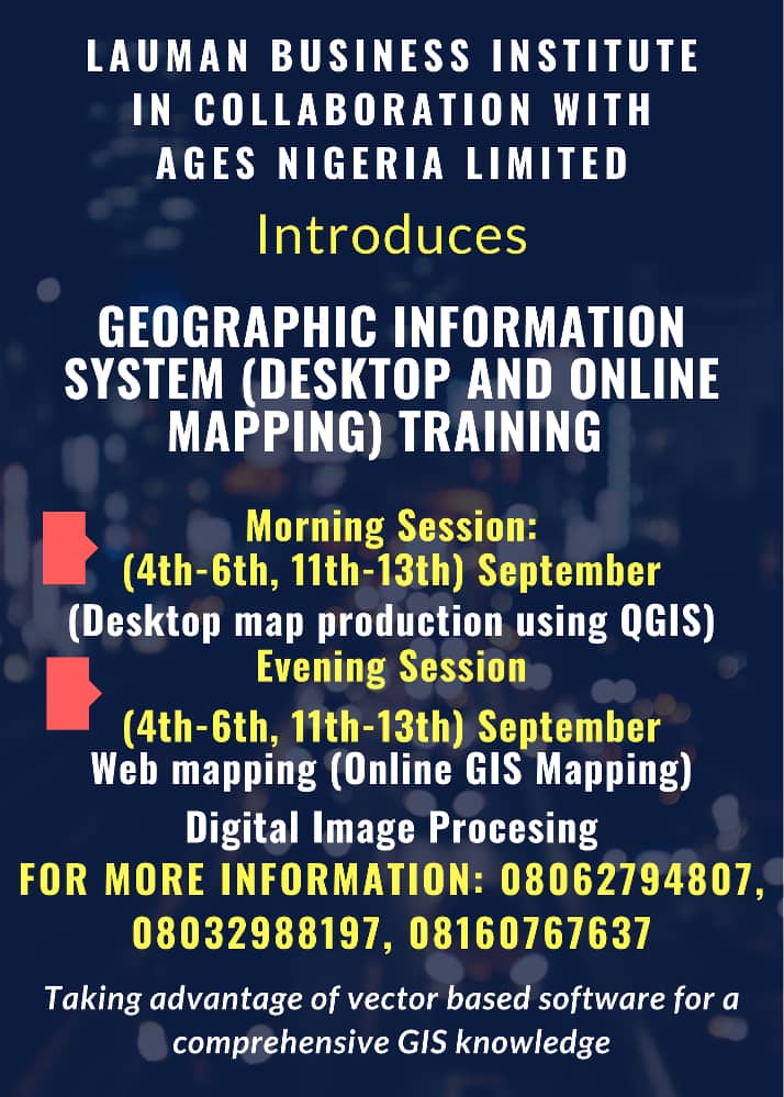
Do you need a GIS expert?
08062794807
English
Do you need a GIS Expert? ADOL Global Environmental Solutions is there to help out. you can also follow us on twitter @MeaaMedia or call us on 08062794807
English
Do you know that neighborhood function of GIS analyzes the relationship between an object and similar surrounding objects? This type of analysis is often used in image processing. Neighborhood functions are valuable in evaluating the character of a local area.
Call 08062794807
English
GIS organizes geographic data so that a person reading a map can select data necessary for a specific project or task. Also, a thematic map has a table of contents that allows the reader to add layers of information to a basemap of real world locations.
Call 08062794807 for more
English
Visualization of data is an extremely important tool for representing and sharing information, especially in the business of media.
The GIS software that makes them are also important tools for understanding the
journalistic side of the industry.
Call 08062794807 for more.
English
The capability of GIS software in handling the spatial data in an easier way coupled with the different analysis tools available make it a viable tool for its adoption in weather forecasting.
We are GIS experts at Adol Global Environmental Solutions.
Call us on 08062794807.
English
At ADOL Global Environmental Solutions (AGES), we train you on how to communicate with the use of maps and other forms of geographic visualization.
You can call on 08062794807, or follow us on our twitter handle, @MeaaMedia.
English
GIS has a unique capability to integrate many kinds of data. It uses spatial location and digital map overlays to analyze content. Maps and data form the underpinnings of GIS, which organizes information into layers that can be visualize and analyzed to uncover meaning in data.
English
By integrating geographic science into everything we do, GIS is improving how we measure and analyze things, as well as how we predict the future. It is also providing better ways to plan, design, and make decisions.
contact: ADOL Global Environmental Solutions, 08062792807.
English
At ADOL Global Environmental Solution (AGES), we help with risk management and analysis by displaying areas that are likely to be prone to natural or man-made disasters. We identify such disasters so that preventive measures can be developed.
AGES…Turning Your Ideas to Reality
English
In this era, a well-developed Geographic Information Systems (GIS) are used to protect the environment. It has become an integrated, well developed and successful tool in disaster management and mitigation.
English
GIS is used as an inquiry-driven, problem-solving, standard-based set of tasks that incorporates fieldwork and provides career pathways that are increasingly.
At ADOL Global Environmental solutions, we provide critical tools for solving very real problems on a daily basis.
English
For centuries, maps have stirred imaginations and inspired explorations of the unknown. Today, maps are used to help understand relationships across areas and regions. These spatial relationships are analyzed using maps in digital form within a Geographical Information System.
English