🐆
6K posts


شفت له مقطع بالتايم
وللأسف اني حدثت التايم بالغلط قبل لاقتبس
بالبداية ونعم بقبيلة زهران العريقة وكلامي لا امسهم فيه ولكن هذا اقتباس لكلامه
بعد ماشتم والدة احد الاشخاص المتواجدين في بثه
وكان يقوله صور قبل لا اتكلم
بعدها قال
"انا يحق لي اقول الي ابي
ابوي زهراني من بني حسن وامي زهرانيه من بني حسن
انا معرب الجديّن"
بعيد عن كلامك القذر يامعرب الجدين 😂
اشغلتنا بعروبتك ورجولتك
وانت تقول ابوك زهراني وخوالك زهارين
معرّب الجدين
يأخي الله يصلحك
معرب الجدين
خواله من قبيلة وعمامه من قبيلة أخرى مختلفة
مثال :
انا مطيري وخوالي حروب - معرب الجدين
الشخص الي عمامه من قبيلة وخواله من نفس القبيلة
يُقال له مردد الجدين
يعني فوق قذارة الكلام واشغلتنا بالعروبة
وانت ماتدري انك مردد الجدين 🤦🏻♂️
وليد@bixwd
طيب لو صورت عند ثلاجة نادك وش الجنسية الي بحصل عليها
العربية

العربية


هذا اذا ما جاه منع من الظهور على وسائل التواصل الاجتماعي
فهذا يعني انه عندنا خلل يجب حله على الفور في المؤسسة الإعلامية‼️
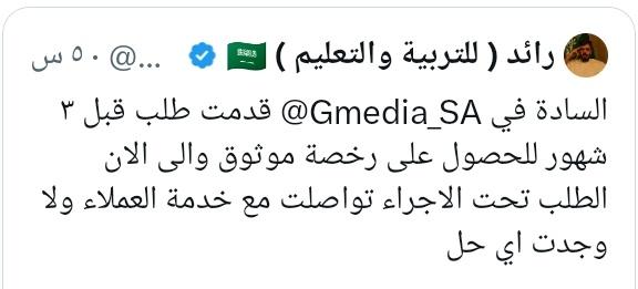
@Gmedia_SA
العربية
العربية

@3BD_Al3zeezZ @Gmedia_SA وش قصته يجيب طاري اهل خصومه دايم
العربية


@Saba2007_ وين والحين اطلقو ع الشرقيه..صفارة الانذار بالخرج !! من يصدق ايران بالله
العربية

انتهت الحرب
وبقيت المملكة العربية السعودية كما هي المصدر الرئيسي لمد العالم بالنفط والغاز ومشتقاتهما
وبقيت دول الخليج العربي هي من يتحكم في الاقتصاد العالمي ولله الحمد
من كانوا فارحين في محاولة استهداف مناطقنا الحيوية بعد انتهاء الأزمة سينتظرون الدعم السعودي لهم
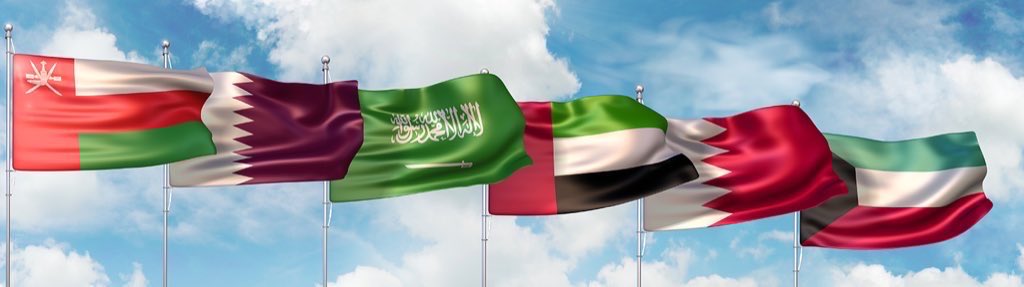
🇴🇲🇸🇦🇰🇼🇦🇪🇶🇦🇧🇭
العربية


العربية

إذا بظهر بوجهي واصير مثلك مجلود من كل شرائح المجتمع اشرف لي اجلس مع اهلي واعتزل السوشل ميديا ..
واحد مجهول يدافع عن وطنه بصدق واخلاص خير من الف واحد منافق متناقض طالع بوجهه وملعن خيره .
@K00000001005
استمر ياكشكول وبارك الله في جهودك 🫡
#ثلاجة_المراعي

العربية

@Sahar_Eldeeb الأب المسؤول الاول والأخير
لازم يجيبوه
لازم يحاسبوا السفارة السعودية لرفض علاجها
الموضوع اكبر من الفقر
العربية

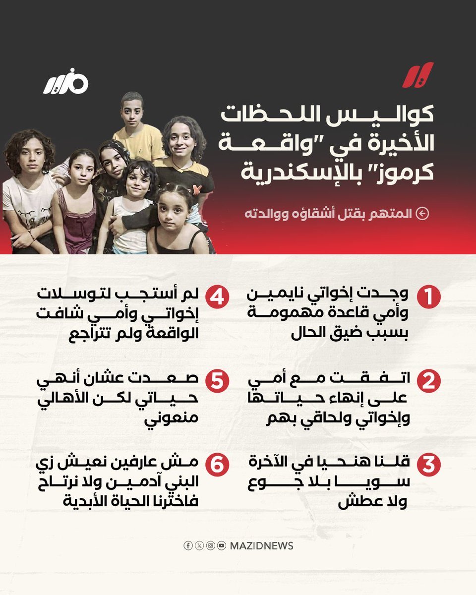
الموضوع ده عملي رعب بشكل مش طبيعي
مش مستوعبة أي تفصيلة ومش هاستوعب
أم تقف تشوف ولادها بيتقتلوا قدامها بسبب الفقر ده موضوع مرعب بجد
روحها ممكن تهون عليها تحت ذل وإنهيار الفقر والخذلان أنما ولادها طيب
المفجع أكتر مش بس اللي حصل المفجع إني شفت ناس كتير بتسأل
ليه الفقرا بيخلفوا ؟
بس ماشفتش ولا واحد سأل
مين اللي خلق الفقر؟
ومين اللي بيسمح له يكبر ويتوحش؟
مين عمل منه وحش ينهش في الناس ويوصلهم لكده ؟
الحقيقة الواضحة اللي الناس بتهرب منها وبتخاف تتكلم فيها هى أن
الفقر مش قدر ، الفقر نتيجة سياسات
واللي بيدير وبيحكم ومسؤول عن توزيع الحياة والفرص هو نفسه المسؤول
عن توزيع الألم والمعاناة
كل نظام بيسيب ناس توصل للحافة
دي هو شريك مباشر في الجريمة
حتى لو ما مسكش السلاح وقتل بنفسه
بس عادي مفيش جديد دايمآ بتلوموا الضحايا وبتبرروا للجناة
أو بتترعبوا منهم
أيهما أقرب بقى !

العربية
@7CCCG @K00000001005 ترا مو اول مره امس كاتب لوحده بكره ترسلي امك واختك عشان اتنازل ..وش ذا
العربية

@K00000001005 تعوذ من بليس ياكشكول ، وهدو الوضع والله رائد اخطاء ومحشومين اهلك الله يخليهم لك لكن هدو ياولد لا تهورون
العربية
@K00000001005 محششششومه اختكككك .. اسحبو عليه ترا حصل احد يعطيه وجهه عقب دعس الامصار له
العربية


@iimbona1 @she7i4 @00_majestic طنشيهم ترا ذولي لو هم خطأ ..مستحيل يقولون انهم خطا وكل شي كذب عندهم.. اطلعي بالجو هالحلو وانسبطي🫰🏻.. امين
العربية

العربية