Kevin Johnson

2.1K posts

Kevin Johnson banner
Kevin Johnson

Kevin Johnson

@KJohnsonOEM

Coordinator of Emergency Management; Loudoun County, Virginia; Be prepared by developing a Plan, Creating a 72-hour supplies kit, and staying informed.

Katılım Aralık 2013
173 Takip Edilen176 Takipçiler
Kevin Johnson retweetledi
NWS Baltimore-Washington
NWS Baltimore-Washington@NWS_BaltWash·
Rain will change to snow later this evening over the mountains before spreading east toward the metros early Monday morning. Highest snowfall totals will be confined to mountains where upslope snow showers will continue through Monday afternoon. #MDwx #VAwx #WVwx
NWS Baltimore-Washington tweet media
English
3
29
63
34.6K
Kevin Johnson retweetledi
NWS Baltimore-Washington
NWS Baltimore-Washington@NWS_BaltWash·
Light to moderate rain continues across northern/central MD with a lull over central VA. This lull will surge north as the afternoon progresses with additional heavy rain & a few t-storms later on. A Flood Watch remains through 1am Monday for the I-95 corridor. #MDwx #VAwx #WVwx
NWS Baltimore-Washington tweet media
English
0
11
16
12.4K
Kevin Johnson retweetledi
NWS Baltimore-Washington
NWS Baltimore-Washington@NWS_BaltWash·
Flood Watches have been expanded across northern and central MD as well as northern VA Sunday afternoon into Sunday night. Rainfall amounts of 2 to 2.50" are expected with locally higher totals across the DC/Baltimore metros. Remember #TurnAroundDontDrown. #MDwx #VAwx #DCwx
NWS Baltimore-Washington tweet media
English
0
31
47
36.4K
Kevin Johnson retweetledi
NWS Baltimore-Washington
NWS Baltimore-Washington@NWS_BaltWash·
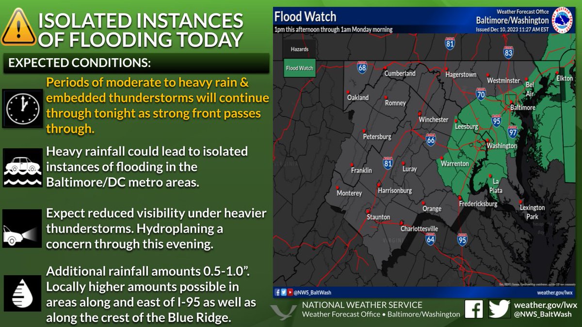
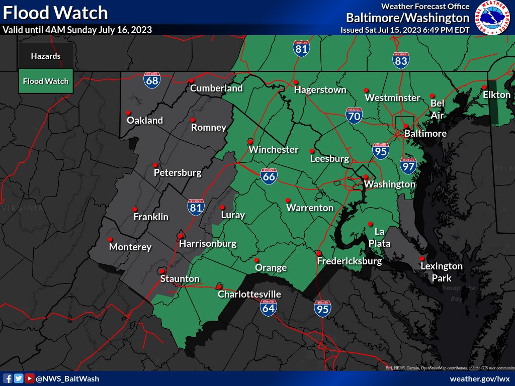
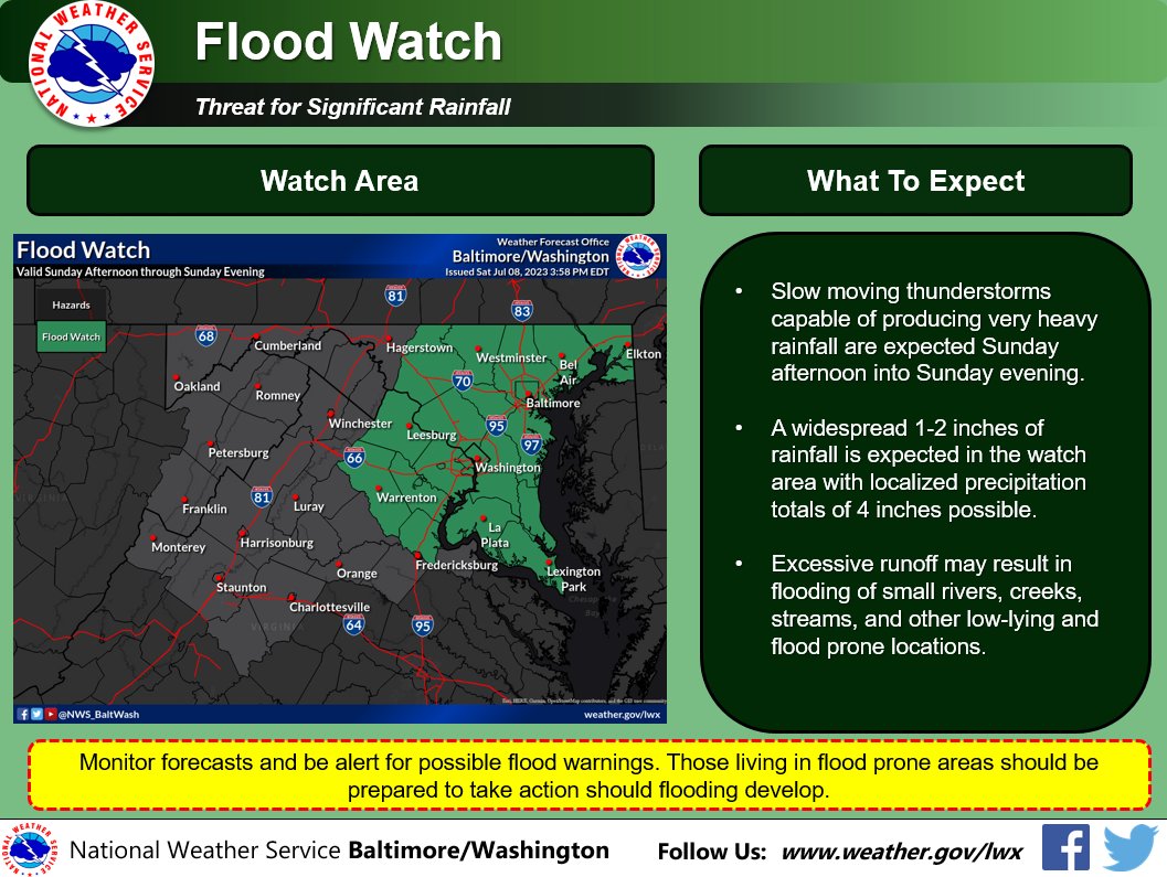
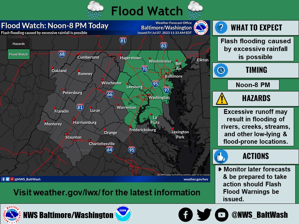
A Flood Watch has been issued for portions of our area along and east of the Blue Ridge until 4AM Sunday. Showers and thunderstorms will be capable of producing heavy rainfall with totals of 1-3 inches and locally higher amounts possible where thunderstorms may train.
NWS Baltimore-Washington tweet media
English
0
43
66
35.9K
Kevin Johnson retweetledi
NWS Baltimore-Washington
NWS Baltimore-Washington@NWS_BaltWash·
Dry/hot start today as temps reach the low-mid 90s in many locations. Scattered to numerous storms expected late afternoon into tonight. Some storms will be severe. Localized flooding is also possible. #MDwx #WVwx #VAwx #DCwx
NWS Baltimore-Washington tweet media
English
0
25
36
13.3K
Kevin Johnson retweetledi
NWS Baltimore-Washington
NWS Baltimore-Washington@NWS_BaltWash·
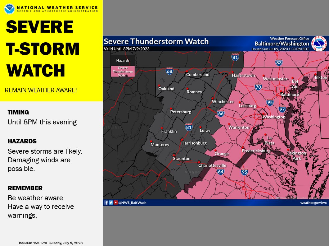
A Severe Thunderstorm Watch has been issued to include the Baltimore and DC metro areas, portions of central VA & central MD, and the surrounding waters until 8PM this evening. Hazards include damaging wind gusts. Stay weather aware at weather.gov/lwx #VAwx #DCwx #MDwx
NWS Baltimore-Washington tweet media
English
1
42
57
46.2K
Kevin Johnson retweetledi
NWS Baltimore-Washington
NWS Baltimore-Washington@NWS_BaltWash·
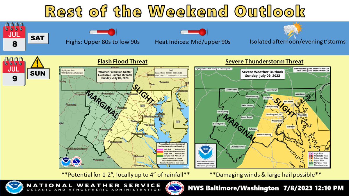
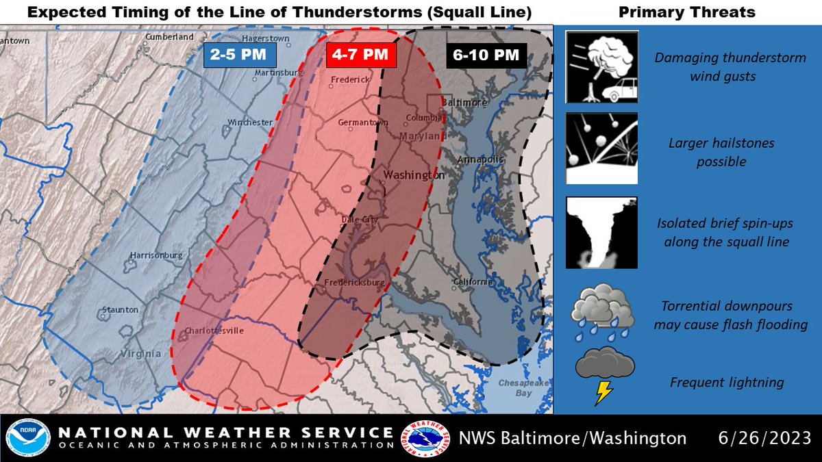
A line of showers and thunderstorms will cross the area today with the potential for flash flooding and locally damaging winds. The greatest risk will be this afternoon for areas generally east of the Blue Ridge Mountains.
NWS Baltimore-Washington tweet media
English
4
59
90
69.8K
Kevin Johnson retweetledi
NWS Baltimore-Washington
NWS Baltimore-Washington@NWS_BaltWash·
A Flood Watch has been issued across the DC & Baltimore metros for Sunday afternoon through Sunday evening. Remember to stay weather aware and if you encounter high water on the road, 'Turn Around, Don't Drown'. #MDwx #VAwx #DCwx
NWS Baltimore-Washington tweet media
English
3
48
70
82.8K
Kevin Johnson retweetledi
NWS Baltimore-Washington
NWS Baltimore-Washington@NWS_BaltWash·
Compared to the past couple of days, thunderstorms are slower to evolve so far today. However, still expect isolated storms to pop up given the ample heat & humidity. Ahead of a cold front, Sunday presents a greater risk for flooding & severe weather. #MDwx #VAwx #DCwx #WVwx
NWS Baltimore-Washington tweet media
English
0
21
45
12.6K
Kevin Johnson retweetledi
NWS Baltimore-Washington
NWS Baltimore-Washington@NWS_BaltWash·
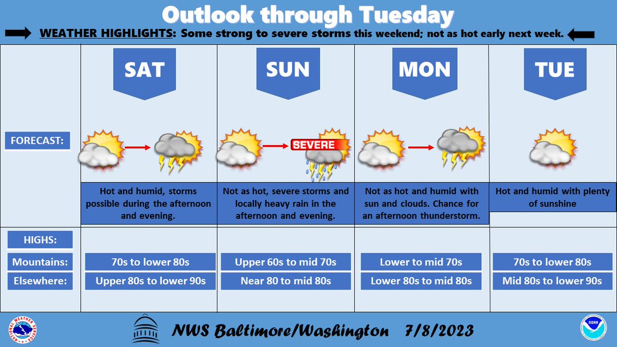
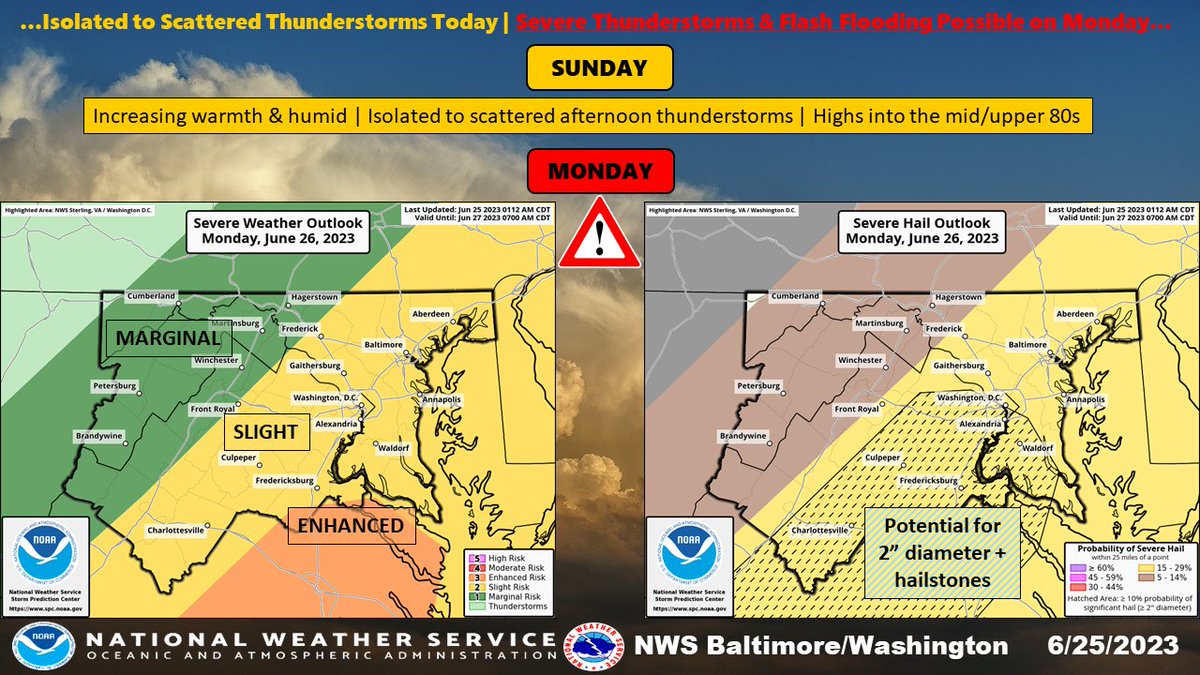
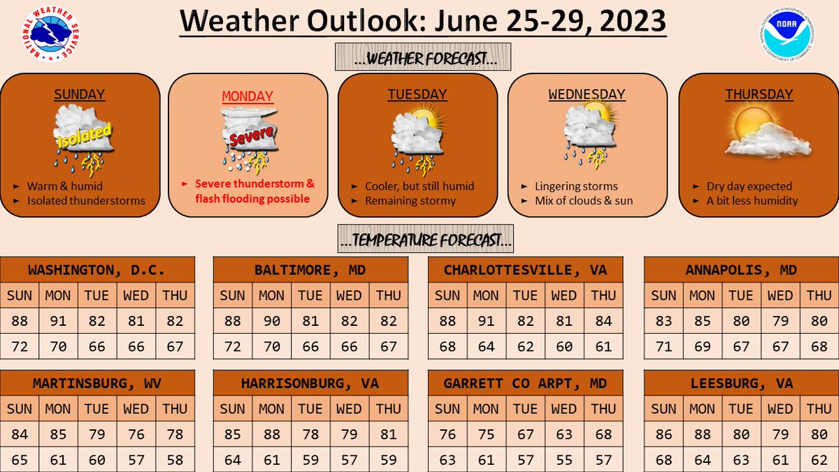
Hot and humid conditions today with scattered showers and thunderstorms this afternoon and evening. Storms are more likely Sunday with the possibility of damaging wind gusts and locally heavy rain. Not as hot nor humid with an isolated afternoon thunderstorm on Monday.
NWS Baltimore-Washington tweet media
English
0
16
28
12.2K
Kevin Johnson retweetledi
NWS Baltimore-Washington
NWS Baltimore-Washington@NWS_BaltWash·
⚠️A Flood Watch has been issued across the DC & Baltimore metros until 8 PM this evening. Very heavy rainfall in a short period of time may cause scattered instances of flash flooding. If you encounter high water on the road, 'Turn Around, Don't Drown'. #MDwx #VAwx #DCwx
NWS Baltimore-Washington tweet media
English
0
45
51
48.4K
Kevin Johnson retweetledi
NWS Baltimore-Washington
NWS Baltimore-Washington@NWS_BaltWash·
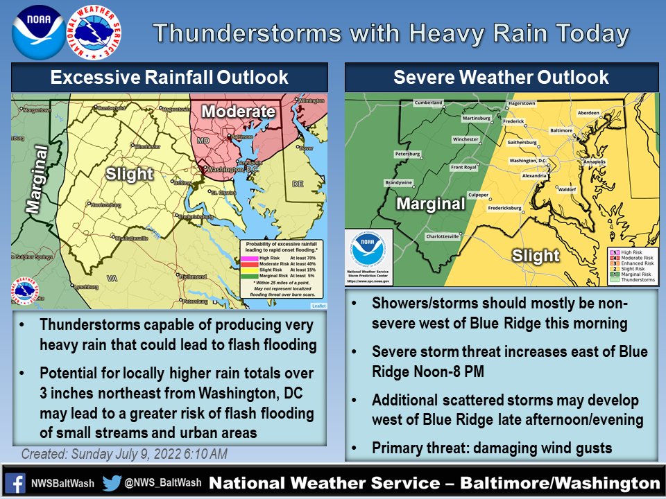
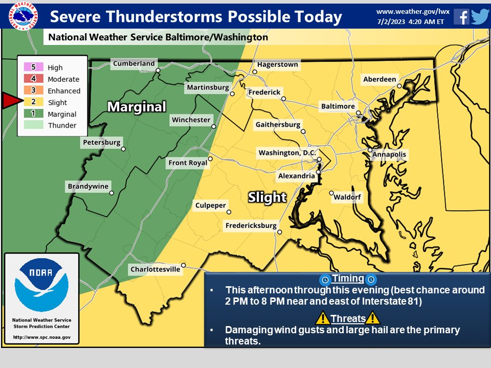
Severe thunderstorms are possible this afternoon and evening. Damaging winds and large hail are the primary threats. See the map for more details.
NWS Baltimore-Washington tweet media
English
4
35
56
29K
Kevin Johnson retweetledi
NWS Baltimore-Washington
NWS Baltimore-Washington@NWS_BaltWash·
Severe thunderstorms are possible this afternoon with localized damaging wind gusts and large hail being the primary threats. Please stay weather aware, and be ready to seek shelter if warnings are issued.
NWS Baltimore-Washington tweet media
English
9
93
150
81.2K
Kevin Johnson retweetledi
NWS Baltimore-Washington
NWS Baltimore-Washington@NWS_BaltWash·
It will be an active weather day as severe thunderstorms are expected to impact areas east of the Alleghenies. These storms are forecast to reach the I-95 corridor during the evening rush hour. Thunderstorm chances persist into the early overnight hours. #MDwx #DCwx #VAwx #WVwx
NWS Baltimore-Washington tweet mediaNWS Baltimore-Washington tweet media
English
4
74
133
162.4K
Kevin Johnson retweetledi
NWS Baltimore-Washington
NWS Baltimore-Washington@NWS_BaltWash·
Summertime conditions continue into the first half of the week. A strong system arriving on Mon will bring an increasing risk for severe thunderstorms & flash flooding. Some of these storms could produce 2" diameter-sized hail. A stormy pattern persists. #MDwx #VAwx #DCwx #WVwx
NWS Baltimore-Washington tweet mediaNWS Baltimore-Washington tweet media
English
4
15
32
13.5K
Kevin Johnson retweetledi
NWS Baltimore-Washington
NWS Baltimore-Washington@NWS_BaltWash·
Most locations remain dry for now with scattered to showers & t-storms expected this afternoon as another piece of energy passes through. Not everyone will see the rain with highs reaching into the 80s. Locally heavy rain is the main threat along with lightning. #MDwx #VAwx #WVwx
NWS Baltimore-Washington tweet media
English
0
9
11
8.5K
Kevin Johnson retweetledi
NWS Baltimore-Washington
NWS Baltimore-Washington@NWS_BaltWash·
Shower & thunderstorm chances increase through late week. 1-3" of rain is expected now-Fri. AM. 2-5" is expected along the crest of the Blue Ridge as well as central VA. Isolated instances of flooding are possible, especially across central VA Wed. night-Thu. #MDwx #VAwx #WVwx
NWS Baltimore-Washington tweet media
English
0
28
43
12.9K
Kevin Johnson retweetledi
NWS Baltimore-Washington
NWS Baltimore-Washington@NWS_BaltWash·
A strong cold front approaching the area will increase the risk for showers & thunderstorms, some of which may become severe. The main threat will be damaging winds. However, the stronger storms may pose the risk of large hail & even a few brief tornadoes. #MDwx #VAwx #DCwx #WVwx
NWS Baltimore-Washington tweet media
English
2
47
61
40.9K
Kevin Johnson retweetledi
NWS Baltimore-Washington
NWS Baltimore-Washington@NWS_BaltWash·
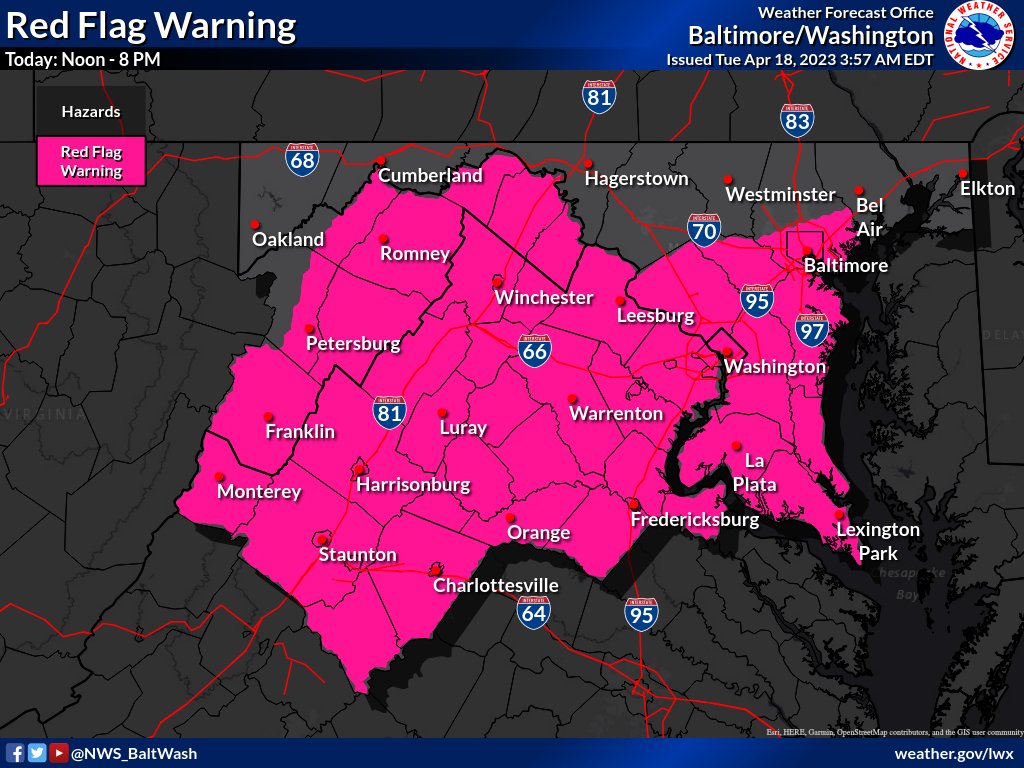
Mostly dry and gusty winds will increase the potential spread of fires today. A Red Flag Warning is in effect for most areas south of I-68/I-70 from noon until 8 PM this evening, with elevated fire dangers still present elsewhere. Visit: weather.gov/lwx for the latest.
NWS Baltimore-Washington tweet mediaNWS Baltimore-Washington tweet media
English
0
34
30
25.3K
Kevin Johnson retweetledi
NWS Baltimore-Washington
NWS Baltimore-Washington@NWS_BaltWash·
Today marks the conclusion of a warm stretch of days as a seasonably strong cold front moves through late this evening and into the overnight. The primary threats will be locally damaging winds (especially for the Alleghenies) & heavy downpours. #MDwx #VAwx #DCwx #WVwx
NWS Baltimore-Washington tweet media
English
0
25
38
15.1K