Live Weather Of India

2.7K posts

Live Weather Of India banner
Live Weather Of India

Live Weather Of India

@LiveWxIndia

©LWI: Aim is to Provide Accurate Precise Location based Weather Forecasts/Services to Farmers & General Public of India. Facebook Est 2016.

India Katılım Ekim 2021
43 Takip Edilen7.2K Takipçiler
Live Weather Of India retweetledi
Weatherman Navdeep Dahiya
Weatherman Navdeep Dahiya@navdeepdahiya55·
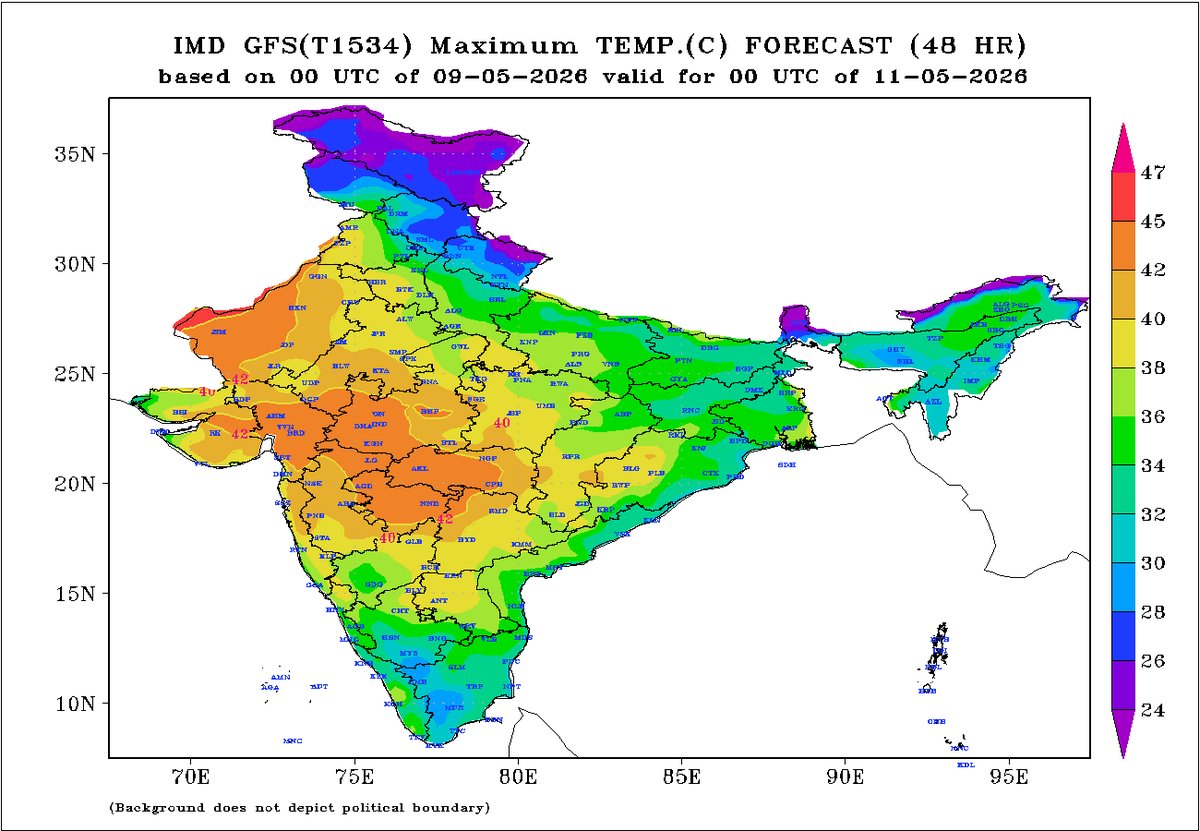
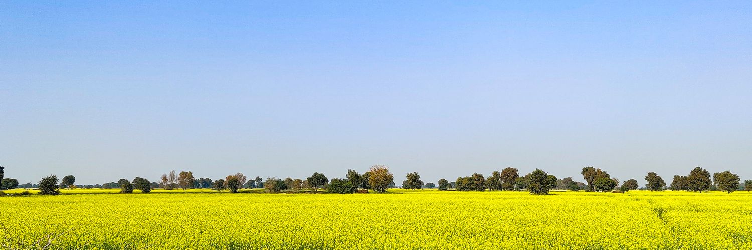
Heatwave sweeps across #Rajasthan & west #MadhyaPradesh Ratlam recorded 46.5°c maximum temperature today, broke it's all time record of 46.2°c from 25th May, 2024 and 46.2°c from 6th June, 2016. #Heatwave is all set to intensify across west India this week, temperatures are set to spike in northern plains from Thursday onwards.
English
3
6
41
1.5K
Live Weather Of India retweetledi
Weatherman Navdeep Dahiya
Weatherman Navdeep Dahiya@navdeepdahiya55·
Duststorm (40-70km/h) followed by a passing spell of moderate rains and thundershowers expected over most parts of north & central #Punjab in next 2-3 hours. Amritsar, Ludhiana, Jalandhar amongst major cities to be affected. Storms to head towards #Chandigarh #Mohali & #Panchkula b/w 5 to 8pm. More developments to take place later in the evening that can impact some parts of #Haryana & #Delhi NCR later tonight. Updates to follow.
Weatherman Navdeep Dahiya tweet media
English
20
10
194
14K
Live Weather Of India retweetledi
Weatherman Navdeep Dahiya
Weatherman Navdeep Dahiya@navdeepdahiya55·
Mild dust storm followed by a short spell of light to moderate showers likely over few parts of Gurgaon and south west Delhi during 10 to 11am. Other parts of Delhi, Faridabad, Noida, Ghaziabad would remain dry apart from Mild dust raising winds. #DelhiRains
English
9
11
195
11.4K
Live Weather Of India retweetledi
Weatherman Navdeep Dahiya
Weatherman Navdeep Dahiya@navdeepdahiya55·
Why are we sweating in May when we should ideally be getting “cooked” at this time of the year? • The anti-cyclonic circulation, which usually pushes dry and hot westerly winds across India, has remained largely inactive since mid-April. As a result, feeble Western Disturbances along with surface-level easterlies have continued to influence east and north India — triggering rains, thunderstorms, and keeping temperatures under check. • Maximum temperatures over the last few days have hovered between 33°C and 37°C in the national capital, Delhi, whereas temperatures during the first 10 days of May would ideally be around 41–42°C. Moist winds possess a higher heat capacity and warm more slowly, which prevents extreme daytime heating. However, the higher humidity significantly increases the “real feel” temperature, leading to excessive sweating compared to dry heatwave conditions. What changes lie ahead • Another feeble Western Disturbance, along with surface easterlies, is expected to trigger dust storms and isolated rainfall across the plains of north India during 11th–13th May. This will continue to keep temperatures under control, although a gradual rise of 1–2°C from current levels is likely over the next three days. • As this weather pattern weakens and moves away, the anti-cyclonic circulation is expected to gradually re-establish itself over west India, pushing dry westerly surface winds into the plains and interior parts of the country. At present, these westerly winds are largely confined to Rajasthan and Gujarat. On 10th May afternoon, Jaisalmer recorded 45.6°C, Barmer 45.4°C, and Ahmedabad 42°C. • Once the dry and hot westerly winds advance further inland, temperatures are set to rise across Punjab, Haryana, Delhi NCR, Uttar Pradesh, Madhya Pradesh, and the remaining parts of Rajasthan, reaching 40–43°C during 13th–16th May, with a further rise anticipated thereafter. • From mid-May onwards, heatwave conditions are expected to make a comeback across most parts of west and central India, along with a few parts of north India.
Weatherman Navdeep Dahiya tweet media
English
8
32
403
33.2K
Live Weather Of India retweetledi
Weatherman Navdeep Dahiya
Weatherman Navdeep Dahiya@navdeepdahiya55·
A feeble Western Disturbance is approaching northwest India, as visible in satellite imagery. It is nowhere close to being a massive WD, as claimed by a few, and unnecessary hype is being created around it. The feeble WD will interact with easterlies and trigger isolated to scattered dust storms, short spells of rain, and thundershowers across Punjab, Haryana, Delhi, and a few parts of north & east Rajasthan and west Uttar Pradesh during 11th–13th May. The activity will mainly occur between evening and early morning hours. Avoid getting caught in unnecessary panic and stay updated with weather updates from trusted sources.
Weatherman Navdeep Dahiya tweet media
English
21
41
482
31.8K
Live Weather Of India retweetledi
Weatherman Navdeep Dahiya
Weatherman Navdeep Dahiya@navdeepdahiya55·
Hot weather conditions likely across west Rajasthan, Gujarat MadhyaPradesh, & Maharashtra as maximum temperatures are expected in the range of 40 to 45°c at most stations. While the day temperatures are in the range of 35 to 39°c in Delhi, Haryana, UttarPradesh, Chandigarh & Punjab - high humidity powered by easterly winds will keep the discomfort high. Sweating weather conditions ahead for north India over this weekend. #Summers #Heat
Weatherman Navdeep Dahiya tweet media
English
4
16
183
13.3K
Live Weather Of India retweetledi
Weatherman Navdeep Dahiya
Weatherman Navdeep Dahiya@navdeepdahiya55·
Cooler May so far! Maximum temperatures continue to stay significantly below normal across north, east & central #India on 7th May. Specifically in #UttarPradesh where max temperature today was 8 to 13°c below normal. Hardoi observatory reported 26°c max temperature making it the coolest day ever recorded in the month of May. As easterlies will persist till this weekend / early next week, heading back to 40°c temperatures look impossible as of now. As the rainfall activities reduces weather can go slightly sultry in the afternoon hours. Evenings and mornings will continue to stay pleasant till 15th May. #Summers
Weatherman Navdeep Dahiya tweet media
English
10
25
270
16.7K
Live Weather Of India retweetledi
Weatherman Navdeep Dahiya
Weatherman Navdeep Dahiya@navdeepdahiya55·
Localised heat induced thunderstorms are forming over #Delhi NCR region. Coverage is low but a few parts (20-40%) to receive short spell of moderate to heavy downpour, pea size hails untill 6pm. Not all places will be covered in this kind of a set up. #DelhiRains
Weatherman Navdeep Dahiya tweet media
English
24
12
186
16.9K
Live Weather Of India retweetledi
Weatherman Navdeep Dahiya
Weatherman Navdeep Dahiya@navdeepdahiya55·
Significantly below normal maximum and minimum temperatures observed in north and east #India in past 48 hours under the influence of western disturbance oriented storms. Day temperatures to rise in upcoming days however would continue to stay below normal atleast till this mid week. Possibility of heat building up in north, west & central India after 10th May.
Weatherman Navdeep Dahiya tweet media
English
6
15
196
17.6K
Live Weather Of India retweetledi
Weatherman Navdeep Dahiya
Weatherman Navdeep Dahiya@navdeepdahiya55·
Storms are showing sluggish movement today while they have matured fully over north #Rajasthan and Pakistan. Strong winds, moderate to heavy thundershowers to impact #Punjab during 11pm - 6am. For #Haryana & #Delhi NCR they to have to cross border barrier and merge with RJ storms, it should ideally take place but as per current analysis nothing is expected in #Delhi NCR & #Chandigarh till mid night (12am). More updates basis movement for impact towards early morning hours.
Weatherman Navdeep Dahiya tweet media
English
21
21
216
20.6K
Live Weather Of India retweetledi
Weatherman Navdeep Dahiya
Weatherman Navdeep Dahiya@navdeepdahiya55·
Storms set up for 4th May ⛈️ • Initial genesis initiated over #Rajasthan and Pakistan. Likely to intensify towards evening hours. • Short spell of moderate to heavy thundershowers and hailstorm likely over various parts of RJ including #Jaipur #Kota #Ajmer #Jodhpur b/w 4 to 8pm. • Storms will head towards #Haryana after 6pm, #Delhi NCR expect impact b/w 8pm to 3am, #Punjab #Chandigarh 9pm to 4am, West #UttarPradesh during 9pm to 3am. • Timings will vary once storms approach mature state by evening hours, there will be better clarity on intensity, coverage as well during evening. More updates to follow. #DelhiRains
Weatherman Navdeep Dahiya tweet media
English
23
24
253
18.9K
Live Weather Of India retweetledi
Weatherman Navdeep Dahiya
Weatherman Navdeep Dahiya@navdeepdahiya55·
Very pleasant morning in #Delhi NCR after overnight storms swept across the region and temperatures are currently in a range of 19 to 21°c in most stations. Windy and pleasant weather will prevail in the afternoon hours, Conditions will become favourable for fresh thunderstorm development by late afternoon in north west #India that should result in more rains and thundershowers in various parts during evening to night hours on 4th May.
Weatherman Navdeep Dahiya tweet media
English
18
29
287
16.7K
Live Weather Of India retweetledi
Weatherman Navdeep Dahiya
Weatherman Navdeep Dahiya@navdeepdahiya55·
Storms that affected #Delhi NCR overnight has moved into UttarPradesh. Duststorm (50-85km/h) accompanied with moderate to heavy rains are expected in #Lucknow #Kanpur and many more districts of central #UttarPradesh b/w 8:30am - 12:30pm. Temperatures to drop significantly.
Weatherman Navdeep Dahiya tweet media
English
8
16
164
10.7K
Live Weather Of India retweetledi
Weatherman Navdeep Dahiya
Weatherman Navdeep Dahiya@navdeepdahiya55·
Storms hit #Rohtak, Haryana with full force, likely to impact and cover most parts of #Delhi NCR in next 1 hour. Chandigarh & Tricity update: Strong winds (50-80km/h) followed by moderate to heavy rains and thundershowers to impact #Chandigarh #Panchkula #Mohali b/w 12 to 2am #DelhiRains #ChandigarhRains
Weatherman Navdeep Dahiya@navdeepdahiya55

Important weather update! Severe storms heading to Delhi NCR b/w 11pm - 2am tonight. Very strong howling wind gust of 60-100km/h followed by heavy rains & thundershowers to impact entire Delhi, Gurgaon, Faridabad Noida, Ghaziabad. Seek shelter immediately once you hear thunder. #DelhiRains

English
22
47
321
61.6K
Live Weather Of India retweetledi
Weatherman Navdeep Dahiya
Weatherman Navdeep Dahiya@navdeepdahiya55·
Important weather update! Severe storms heading to Delhi NCR b/w 11pm - 2am tonight. Very strong howling wind gust of 60-100km/h followed by heavy rains & thundershowers to impact entire Delhi, Gurgaon, Faridabad Noida, Ghaziabad. Seek shelter immediately once you hear thunder. #DelhiRains
English
63
131
906
110K
Live Weather Of India retweetledi
Weatherman Navdeep Dahiya
Weatherman Navdeep Dahiya@navdeepdahiya55·
Severe storms alert ⚠️ Intense thunderstorm over west #Haryana is headed to #Delhi NCR towards mid-night. Duststorm accompanied with 50-80km/h wind gusts, short spell of moderate to heavy rains and thundershowers likely across #Delhi NCR & various districts of east & central #Haryana b/w 11pm - 3am. Risk of hailstorm at a few places as well. Stay indoors during the storm. Stay safe #DelhiRains
Weatherman Navdeep Dahiya tweet media
English
33
73
356
25.7K
Live Weather Of India retweetledi
Weatherman Navdeep Dahiya
Weatherman Navdeep Dahiya@navdeepdahiya55·
Severe thunderstorms have started to develop over parts of north #Rajasthan now. Video from Rawatsar in Hanumangarh district with #hailstorm in the evening. Scattered thunderstorms, hails expected in more districts of N RJ, #Haryana up to #Delhi NCR during night - early morning hours. #Punjab to experience storms during mid night into morning hours tomorrow. On 4th may - tomorrow evening: Fresh intense thunderstorms will develop in plains of north west india which will bring strong winds (50-100km/h), rains and even hails. Will update latest basis development of thundercells and steering.
English
16
66
355
28.2K
Live Weather Of India retweetledi
Weatherman Navdeep Dahiya
Weatherman Navdeep Dahiya@navdeepdahiya55·
A cluster of dust front over #Haryana #Delhi & north #Rajasthan right now, wind gust are up to 30-40km/h. This should continue with varied intensity throughout afternoon. Scattered thundershowers will start developing in north west #India from evening hours. Limited impact today while widespread storms are predicted on Monday. Atmospheric conditions are very unstable in plains at the moment, patterns will keep on shifting within a few hours. Follow nowcasts for latest updates.
Weatherman Navdeep Dahiya tweet media
English
17
22
272
17.9K