NWS Kansas City

39.1K posts

NWS Kansas City banner
NWS Kansas City

NWS Kansas City

@NWSKansasCity

This is the official twitter account for the National Weather Service in Kansas City/Pleasant Hill, MO. Details: https://t.co/4lS68fk4cU

Kansas City/Pleasant Hill, MO Katılım Mayıs 2011
391 Takip Edilen115.9K Takipçiler
NWS Kansas City
NWS Kansas City@NWSKansasCity·
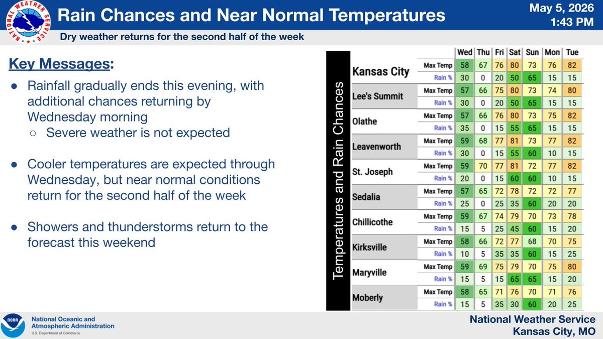
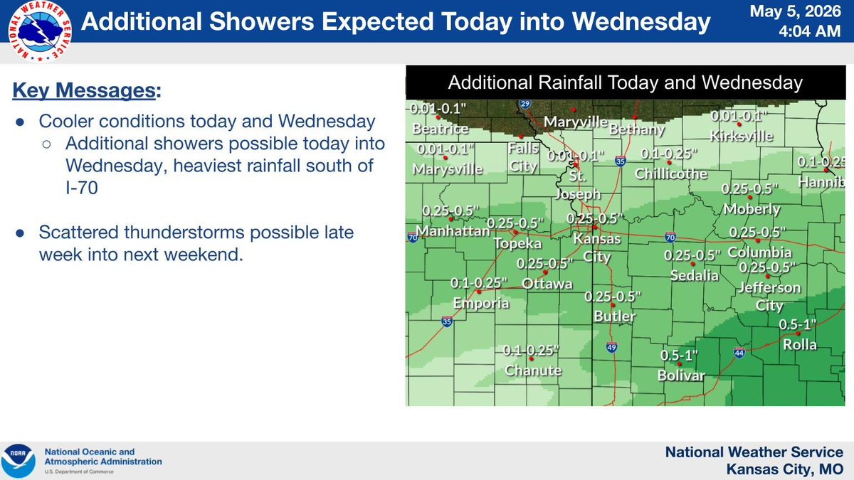
Below normal temperatures are expected today, but warming conditions are expected to round out the week. A couple of chances of showers and thunderstorms are possible late on Friday and Saturday, though no severe weather is expected.
NWS Kansas City tweet media
English
0
3
16
3.1K
NWS Kansas City
NWS Kansas City@NWSKansasCity·
Cool and rainy conditions expected through Wednesday, but dry and near-normal conditions return for the second half of the week. Showers and storms return to the forecast this weekend.
NWS Kansas City tweet media
English
0
3
16
3.5K
NWS Kansas City
NWS Kansas City@NWSKansasCity·
After an overnight cold front, cooler weather is settling into the region today. Expect scattered showers at times, with the heaviest rain likely along and south of I-70.
NWS Kansas City tweet media
English
0
2
22
4.8K
NWS Kansas City
NWS Kansas City@NWSKansasCity·
Severe Thunderstorm Warning including Jacksonville MO and Excello MO until 11:00 PM CDT
NWS Kansas City tweet media
English
1
0
6
4.1K
NWS Kansas City
NWS Kansas City@NWSKansasCity·
Severe Thunderstorm Warning including Macon MO, Bevier MO and Callao MO until 10:30 PM CDT
NWS Kansas City tweet media
English
0
1
8
4.6K
NWS Kansas City
NWS Kansas City@NWSKansasCity·
@garynickerson62 There is a radar page outage unfortunately. Good news is it is being worked on as we speak.
English
1
0
2
383
NWS Kansas City
NWS Kansas City@NWSKansasCity·
We’re tracking storms in the area tonight and need your help! If you’ve experienced hail or strong winds, please share your report with us. Be sure to include: • Your location • The approximate time it happened Bonus points for photos— they really help us see what’s going on!
English
4
7
46
9.7K
NWS Kansas City
NWS Kansas City@NWSKansasCity·
Severe Thunderstorm Warning including Macon County, MO until 9:45 PM CDT
NWS Kansas City tweet media
English
0
0
7
4.7K
NWS Kansas City
NWS Kansas City@NWSKansasCity·
Severe Thunderstorm Warning including Slater MO, Brunswick MO and Bosworth MO until 8:45 PM CDT
NWS Kansas City tweet media
English
0
0
7
4.2K
NWS Kansas City
NWS Kansas City@NWSKansasCity·
Severe Thunderstorm Warning including Carrollton MO, Bosworth MO and Bogard MO until 8:00 PM CDT
NWS Kansas City tweet media
English
0
0
4
4.3K
NWS Kansas City
NWS Kansas City@NWSKansasCity·
Severe Thunderstorm Warning including Braymer MO, Polo MO and Kingston MO until 7:15 PM CDT
NWS Kansas City tweet media
English
0
0
6
3.7K
NWS Kansas City
NWS Kansas City@NWSKansasCity·
A strong cold front is expected to build south across the region tonight leading to showers and thunderstorms. Some of these storms may be strong to severe producing large hail and damaging straight line winds.
NWS Kansas City tweet media
English
0
2
33
5.5K
NWS Kansas City
NWS Kansas City@NWSKansasCity·
Isolated storms possible Sunday evening - early Monday AM with a low severe risk (hail/wind). More widespread storms arrive Monday evening - overnight, with a few producing large hail and damaging straight-line winds.
NWS Kansas City tweet media
English
0
8
28
6.5K
NWS Kansas City
NWS Kansas City@NWSKansasCity·
Isolated storms are possible tonight, with a risk of large hail or damaging winds. More widespread storms are expected Monday evening into the overnight hours, some of which could also produce gusty winds and large hail.
NWS Kansas City tweet media
English
1
3
41
7.2K
NWS Kansas City
NWS Kansas City@NWSKansasCity·
Cold fronts are expected to move south across the region on Sunday and Monday evenings, potentially triggering scattered thunderstorms. Some of these storms could produce large hail and damaging straight-line winds.
NWS Kansas City tweet media
English
0
9
35
6K
NWS Kansas City
NWS Kansas City@NWSKansasCity·
Another cold front is expected to move through the region on Friday creating a few light showers or sprinkles across the region. Low temperatures tonight are expected to fall into the 30s. A frost advisory is in effect for northern Missouri.
NWS Kansas City tweet media
English
0
8
37
6K
NWS Kansas City
NWS Kansas City@NWSKansasCity·
Just before 7:30 AM CDT on April 27, 2026, an EF-0 tornado formed between the communities of Higbee and Renick in Missouri. The tornado produced mostly tree damage and gradually weakened as it approached the Monroe County line. #mowx
NWS Kansas City tweet media
English
1
8
21
4.7K
NWS Kansas City
NWS Kansas City@NWSKansasCity·
Around 7:11 AM CDT on April 27, 2026, an EF-1 tornado touched down in Chariton County, MO and continued into Randolph County, MO. The tornado damaged several residences, outbuildings, and hundreds of trees along its nearly 25 mile path. #mowx
NWS Kansas City tweet media
English
0
11
28
5.1K
NWS Kansas City
NWS Kansas City@NWSKansasCity·
@adstalga Hi Andrew, did you see our post/update later in the day on the tornado in that area? There was a confirmed tornado that went into Glasgow. Here is the link to that post from yesterday afternoon/evening: x.com/NWSKansasCity/…
NWS Kansas City@NWSKansasCity

At 6:52 AM CDT on April 27, 2026, a tornado developed southwest of Slater, MO. The tornado impacted the communities of Slater, Gilliam, and Glasgow on its 36.51 mile path, peaking in strength in and near Gilliam where several points of EF-2 damage were identified. #mowx

English
0
0
0
44
NWS Kansas City
NWS Kansas City@NWSKansasCity·
Slightly cooler temperatures the next few days across the area. Light rain forecast on Thursday. Warm up starts back up on Sunday.
NWS Kansas City tweet media
English
1
3
24
3.8K