
NWS Austin/San Antonio

57.6K posts

NWS Austin/San Antonio banner
NWS Austin/San Antonio

NWS Austin/San Antonio

@NWSSanAntonio

Official X account for the National Weather Service Austin/San Antonio. Details: https://t.co/c97VpqKERb

New Braunfels, Texas Katılım Mayıs 2012
265 Takip Edilen84.2K Takipçiler
NWS Austin/San Antonio
NWS Austin/San Antonio@NWSSanAntonio·
A Flood Watch has been issued through Wednesday morning. Rain amounts generally from 1-3 inches with pockets up to 5 inches are expected which could lead to rapid, life-threatening flooding of rivers, creeks, and low-lying areas. Never drive through flooded roads! #txwx
NWS Austin/San Antonio tweet media
English
0
14
37
2.8K
NWS Austin/San Antonio
NWS Austin/San Antonio@NWSSanAntonio·
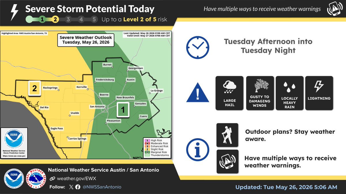
Tuesday: Strong to severe storms are possible across south central Texas today. Large hail and damaging winds are the main severe weather concerns. Have multiple ways to receive warning information! In addition, locally heavy rainfall my lead to flash flooding.
NWS Austin/San Antonio tweet mediaNWS Austin/San Antonio tweet media
English
2
19
53
5K
NWS Austin/San Antonio
NWS Austin/San Antonio@NWSSanAntonio·
@Mike97233283210 Hi, where are you located or can you send the link to the forecast you're seeing? It could say showers but the mention of thunderstorms should also be in there.
English
0
0
0
39
Mike
Mike@Mike97233283210·
@NWSSanAntonio On your website it says "showers" tonight and tommorow. Nothing serious I guess
English
1
0
0
47
NWS Austin/San Antonio
NWS Austin/San Antonio@NWSSanAntonio·
9:10 PM: Showers and storms continue in portions of Bastrop, Lee, and Williamson counties. Area lightning and strength of storms has decreased over the past hour. Expect this trend to continue with activity dissipating with less instability with the loss of daytime heating. #txwx
English
0
4
21
2.9K
NWS Austin/San Antonio
NWS Austin/San Antonio@NWSSanAntonio·
A special weather statement has been issued for McDade TX and Paige TX until 8:45 PM CDT
NWS Austin/San Antonio tweet media
English
0
1
7
2.2K
NWS Austin/San Antonio
NWS Austin/San Antonio@NWSSanAntonio·
7:40 PM: Showers and storms focused primarily in Lee, Travis, and Williamson counties at this time. An individual cell also across Kerr County west of I-10 as well. Gusty winds, cloud-to-ground lightning, and locally heavy downpours are possible with this activity. #txwx
English
0
3
17
2.5K
NWS Austin/San Antonio
NWS Austin/San Antonio@NWSSanAntonio·
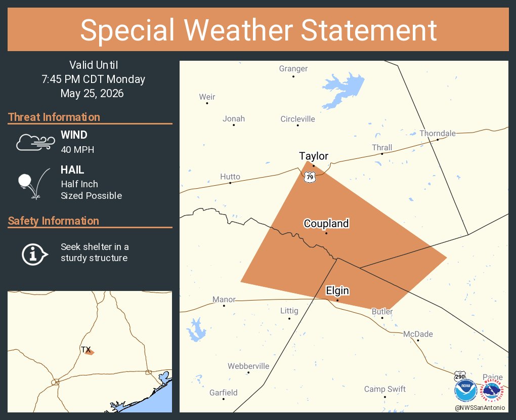
A special weather statement has been issued for Taylor TX, Elgin TX and Coupland TX until 7:45 PM CDT
NWS Austin/San Antonio tweet media
English
0
2
6
2.2K
NWS Austin/San Antonio
NWS Austin/San Antonio@NWSSanAntonio·
A special weather statement has been issued for Round Rock TX, Georgetown TX and Brushy Creek TX until 7:30 PM CDT
NWS Austin/San Antonio tweet media
English
0
4
6
2.7K
NWS Austin/San Antonio
NWS Austin/San Antonio@NWSSanAntonio·
A special weather statement has been issued for Kerr County, TX until 7:30 PM CDT
NWS Austin/San Antonio tweet media
English
0
1
3
2K
NWS Austin/San Antonio
NWS Austin/San Antonio@NWSSanAntonio·
6:10 PM: Shower and storm activity is slowly moving eastward from the Hill Country with a new cell over Austin producing lightning and a heavy downpour. Flash Flood Warning remains from runoff from earlier heavy rain near Johnson City. Outflow winds approaching San Antonio. #txwx
English
0
7
27
4K
NWS Austin/San Antonio
NWS Austin/San Antonio@NWSSanAntonio·
Aviso de Inundación Repentina incluye Johnson City TX hasta las 8:15 PM CDT
NWS Austin/San Antonio tweet media
Español
0
2
1
2.1K
NWS Austin/San Antonio
NWS Austin/San Antonio@NWSSanAntonio·
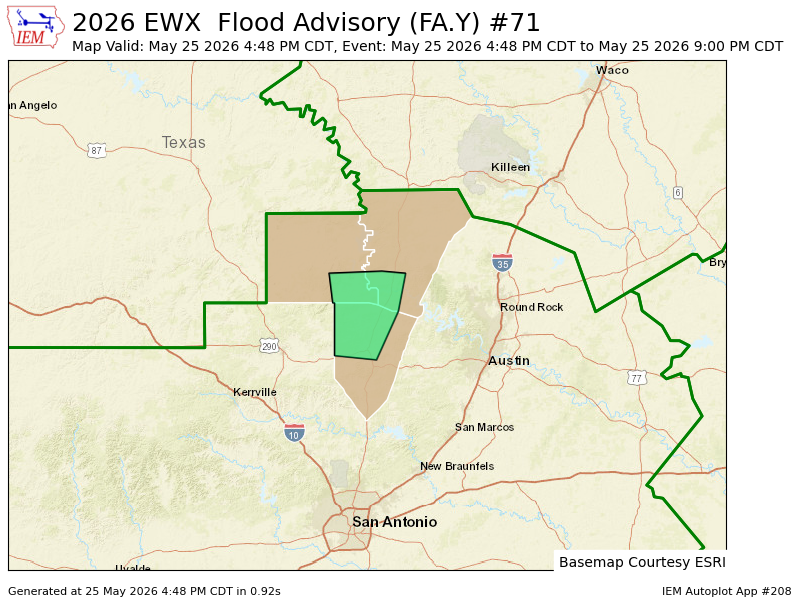
Flash Flood Warning including Johnson City TX until 8:15 PM CDT
NWS Austin/San Antonio tweet media
English
0
6
9
2K
NWS Austin/San Antonio
NWS Austin/San Antonio@NWSSanAntonio·
4:25 PM: Spotty slow moving showers and storms are ongoing across portions of the Hill Country and the highway 71 corridor. Any heavier cells are producing locally heavy rain with isolated 1 to 2 inches in a short time and frequent lightning. When thunder roars, go indoors! #txwx
English
1
9
24
3.4K
NWS Austin/San Antonio
NWS Austin/San Antonio@NWSSanAntonio·
Level 2 of risk for severe storms and Level 2 of 4 risk for excessive rain and flooding Tue PM thru Wed AM. Large hail, damaging winds, frequent lightning. Have multiple ways to receive warning information! #txwx
NWS Austin/San Antonio tweet mediaNWS Austin/San Antonio tweet media
English
0
8
43
6.4K
NWS Austin/San Antonio
NWS Austin/San Antonio@NWSSanAntonio·
2:25 PM: Showers and thunderstorms are starting to develop over the Hill County into the northern I-35 corridor this afternoon. Storms will be slow moving today and isolated locations could pick up 1-2 inches of rain. #txwx
English
1
12
27
6.3K
NWS Austin/San Antonio
NWS Austin/San Antonio@NWSSanAntonio·
The chance for strong to severe storms returns to portions of south central Texas Tuesday afternoon into early Wednesday. Large hail and damaging winds are the main severe weather concerns. Locally heavy rainfall will also be possible across all areas on Tuesday and Wednesday.
NWS Austin/San Antonio tweet mediaNWS Austin/San Antonio tweet media
English
0
17
46
4.3K
NWS Austin/San Antonio
NWS Austin/San Antonio@NWSSanAntonio·
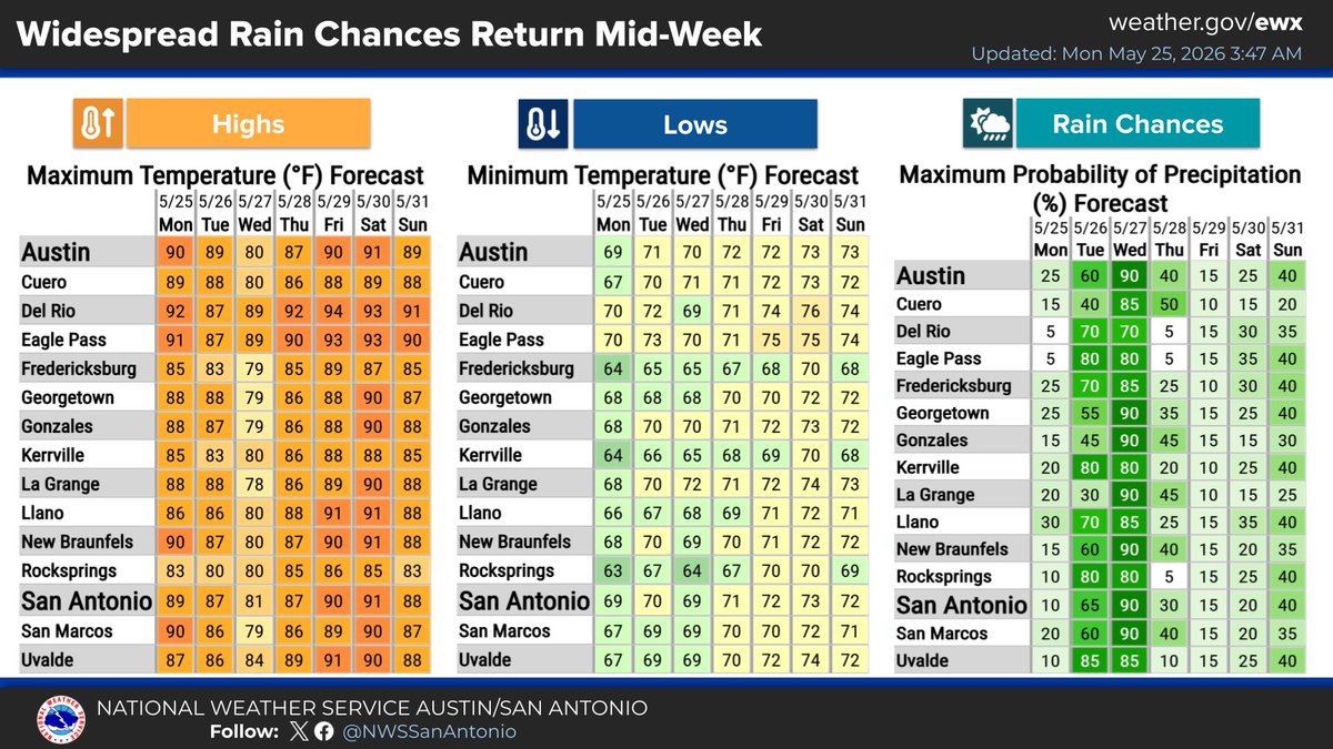
Another period of widespread and potentially heavy rain is expected Tuesday into Wednesday. Additional rain chances are shown for the upcoming weekend.
NWS Austin/San Antonio tweet media
English
0
0
6
1.7K
NWS Austin/San Antonio
NWS Austin/San Antonio@NWSSanAntonio·
Monday: High temperatures will range from the lower 80s to lower 90s today. Mainly afternoon showers and storms will be possible for areas generally along and north of Interstate 10.
NWS Austin/San Antonio tweet media
English
1
5
22
2.7K