“The data we receive from Geotab has helped us improve the performance of our services.” - Matt Carney, CEO, Go-Ahead Bus
Full case study in first reply ↓
ow.ly/muEl50YO7oe
@TheGoAheadGroup , the UK’s largest bus operator in London, is using Geotab real-time diagnostics to help prevent catastrophic engine failures across 6,000 buses.
The challenge: Managing 2,500 buses in London alone, one of the most complex transit environments in the world.
The solution: GO9 telematics flags low oil pressure and coolant faults the moment they appear.
The results:
-£20,000 saved per engine by catching faults before failure
-10+ breakdowns prevented in the first month
-Live EV state-of-charge monitoring as Go-Ahead works toward a zero-emission fleet by 2035
Maintenance Overview page is a real-time view of issues, trends, and downtime risk across your fleet so you know what needs attention before a vehicle goes down.
Most fleets find out about a problem when it is already too late.
Now featured in Geotab Signals Winter '26.
Some things just are not meant to be put on ice. The Next Gen GO is one of them 🧊
One device. Vehicles, assets and operations, all data in one place.
All the tracking the GO9 delivers, plus more.
The thaw is here 🔥
What's different:
✔️ Native Bluetooth: asset visibility, no extra hardware
✔️ MyInstall Data Labeling: maps to MyGeotab at install, zero manual configuration
✔️ Energy reserve: tamper alert fires the second power is cut
✔️ Integrated I/O pins: monitor PTO, doors and lights directly
Vehicle tracking and asset tracking have lived in separate systems for too long.
The Next Gen GO is now generally available to close that gap [Thread 🧵]
Data from Altitude by Geotab shows that stop durations on the I-10 corridor scale with driving leg length, providing the longest charging windows precisely where batteries would be most depleted.
Median stop durations rise from roughly 1 hour after legs under 100 miles to over 1.5 hours after legs between 300 and 400 miles, and around 30% of all end-of-leg stops exceed 10 hours, meaning charging fits into existing dwell time without adding downtime to fleet schedules.
NEW: @SwiftRideLLC eliminated vehicle theft entirely, from 15% of its fleet to zero, using Geotab’s GO device, remote immobilization, and open API.
Delinquency dropped from 70% to under 10%, while fleet utilization increased from 70% to 95%.
Data from Altitude by Geotab shows that electrifying only the shortest driving legs on the I-10 corridor would eliminate a meaningful share of the route's fuel use and emissions without requiring full-corridor EV coverage.
Targeting legs under 200 miles could save 138 million gallons of diesel and 9.9 million metric tons of greenhouse gas emissions annually, out of the corridor's total 658 million gallons and 47 million metric tons.
How police departments use telematics to improve public trust:
(00:00) How Can One Complaint Turn Into a “He Said, She Said” Situation?
(00:52) How Does Telematics Help Build Trust and Accountability in Public Safety?
(01:32) How Can Data-Driven Transparency Protect Your Department’s Integrity?
(03:16) How Does Telematics Improve Officer Safety and Incident Response?
(05:00) How Can Telematics Improve Patrol Coverage and Community Trust?
(07:01) How Can You Optimize Fleet Budget and Reduce Operational Costs?
(09:02) How Do AI and Data Help Prepare Public Safety Fleets for the Future?
(10:50) What Are the Key Benefits of Telematics for Public Safety Fleets?
Data from Altitude by Geotab shows that median driving leg distances at every proposed charging hub along the I-10 fall well below the 200-mile range of mid-range electric trucks, making typical corridor freight already compatible with current EV technology.
At all seven sites from Rialto to Vado, median driving legs cluster between roughly 60 and 145 miles, with even the 75th percentile staying near the 200-mile threshold, meaning shared charging hubs would serve the bulk of everyday corridor traffic.
Data from Altitude by Geotab shows that driving legs along the I-10 corridor are well-matched to current electric truck range at every proposed charging hub between Los Angeles and El Paso.
Across seven sites spaced roughly 150 miles apart, at least 59% of driving legs are under 200 miles at every location, reaching 80% at Palm Springs and even at longer-leg sites like Lordsburg, 87% of trucks travel under 400 miles between stops.
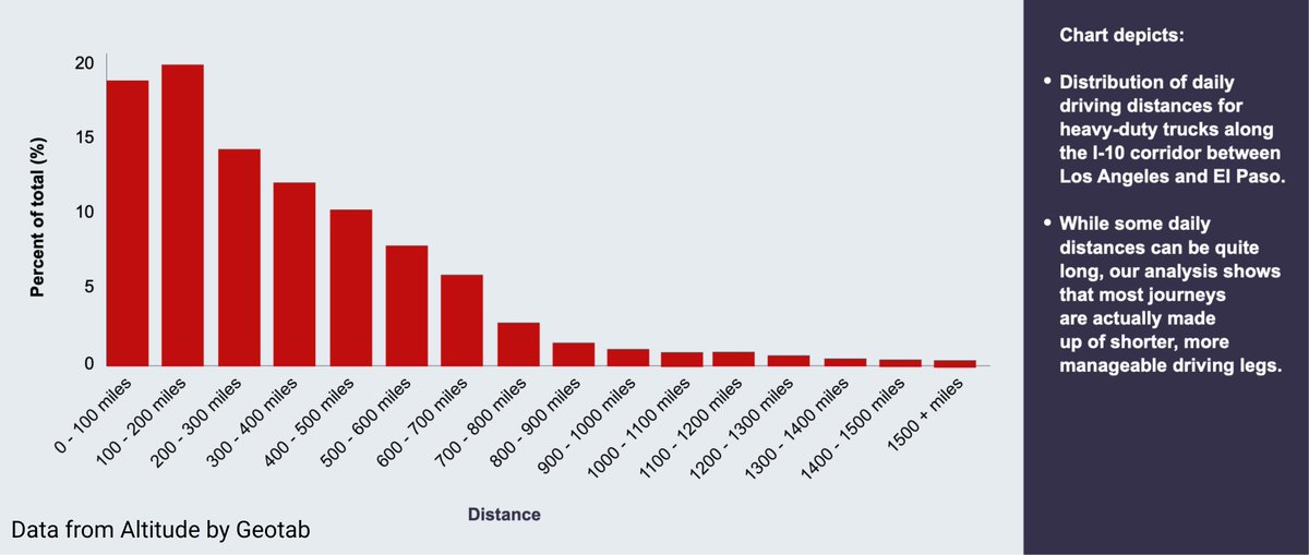
Data from Altitude by Geotab shows that daily driving distances on the I-10 corridor are far shorter than the route's 800-mile length suggests, putting most trucks within range of current electric technology.
The 100-200 mile bracket is the most common daily distance at ~20%, with the 0-100 mile range close behind at ~19%, while trips exceeding 700 miles in a single day are rare, meaning electrification is operationally viable for the majority of I-10 fleets today.
GO Anywhere Plus is a rugged, durable, and reliable asset tracker for powered and non-powered fleet equipment.
Wired or battery-powered.
Better visibility = better utilization decisions.
Satellite connectivity is available through select carrier partners.