Weather Authority

41.1K posts

Weather Authority banner
Weather Authority

Weather Authority

@theWXauthority

Getting you the latest information on weather conditions across central Indiana powered by @CBS4Indy and @FOX59

Indianapolis, IN Katılım Mayıs 2009
128 Takip Edilen8.8K Takipçiler
Weather Authority retweetledi
Ethan Rosuck
Ethan Rosuck@EthanRosuckWX·
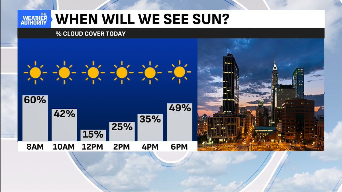
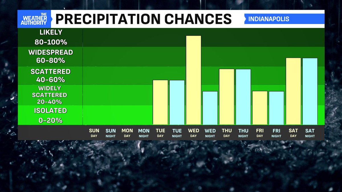
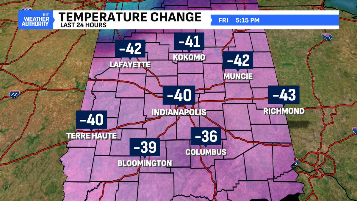
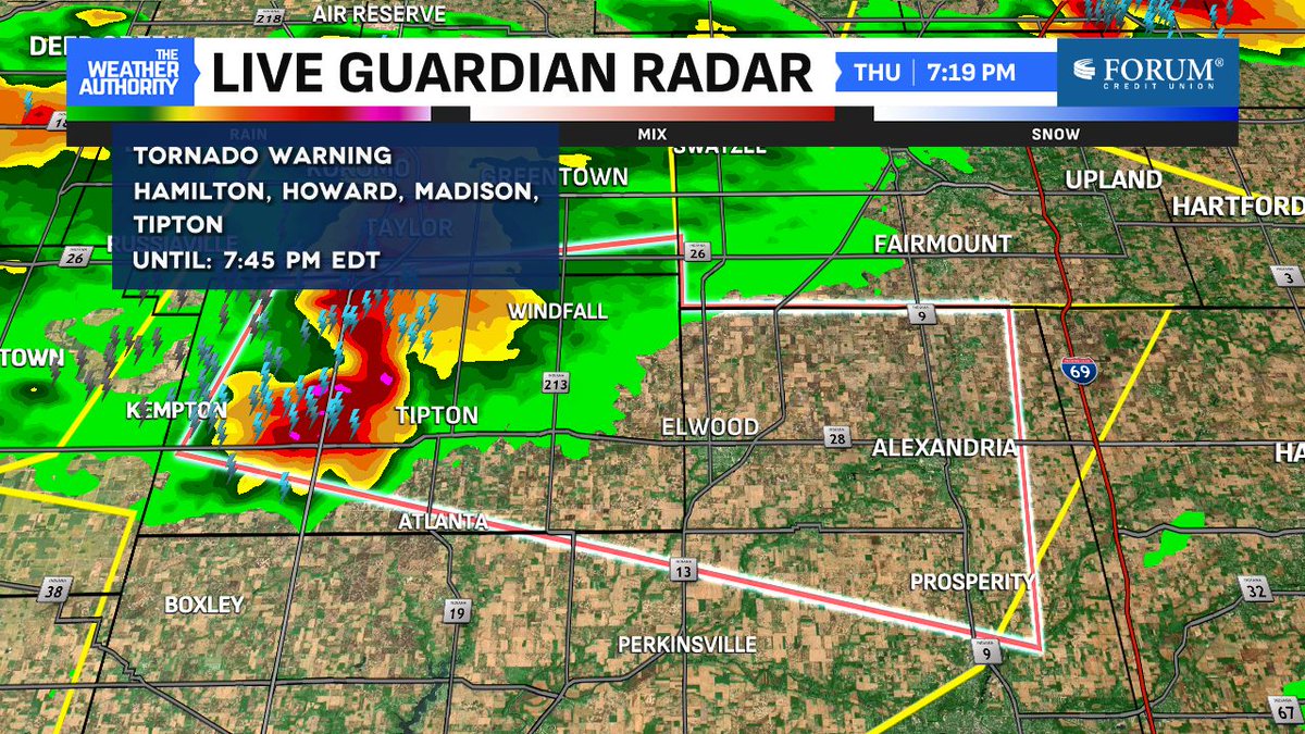
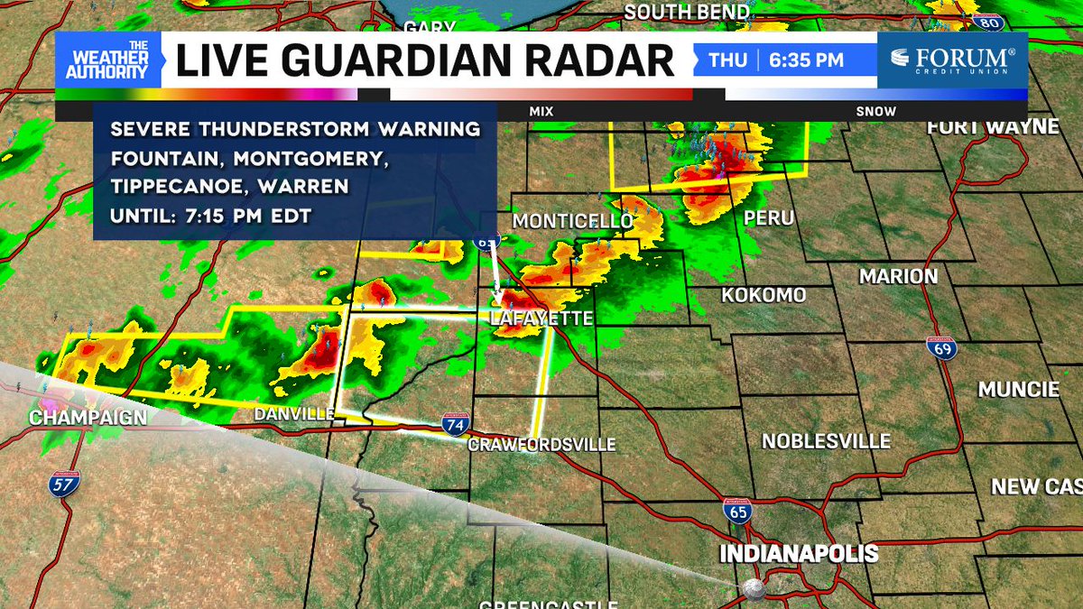
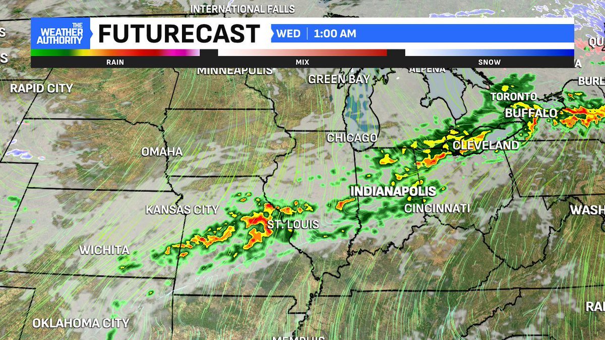
A warming trend starts today. The warmth peaks on Tuesday ending March with highs around 25° ABOVE normal. More upper 70s to near 80° possible. Much like we've been used to, the warmth comes to an end with a cold front and showers/storms. Coverage increases late Tuesday. #INwx
Ethan Rosuck tweet mediaEthan Rosuck tweet media
English
0
5
9
1.8K
Weather Authority retweetledi
Ethan Rosuck
Ethan Rosuck@EthanRosuckWX·
We'll be warming quite nicely back to above-normal territory with highs in the mid-to-low 60s. More clouds will be in the sky compared to yesterday but an overall nice day is ahead. The warmth will be aided by breezy southwest winds today, too. #INwx @FOX59
Ethan Rosuck tweet mediaEthan Rosuck tweet mediaEthan Rosuck tweet media
English
0
5
8
1.7K
Weather Authority retweetledi
Ethan Rosuck
Ethan Rosuck@EthanRosuckWX·
Welcome to the final Sunday of March! Nice sunrise a low cloud deck present in our skies this morning. A bit chilly but not as cold compared to yesterday. We'll warm up starting today and turn the wind machine back on, too. #INwx @FOX59
Ethan Rosuck tweet media
English
0
3
7
1.7K
Weather Authority retweetledi
Ethan Rosuck
Ethan Rosuck@EthanRosuckWX·
Another warming trend begins Sunday. The warmth PEAKS Tuesday with more highs in the upper 70s/near 80°. This will be the environment set up ahead of our next storm chances which go into Wednesday. More rain chances exist for April's opening days next week. #INwx @FOX59
Ethan Rosuck tweet mediaEthan Rosuck tweet media
English
1
4
5
1.7K
Weather Authority retweetledi
Ethan Rosuck
Ethan Rosuck@EthanRosuckWX·
High pressure in control keeps clouds away forthe Midwest! Expect sunshine Saturday with seasonably cooler highs around 50°. Warming conditions return Sunday with highs in the 60s. It'll be breezy with increasing clouds. Not bad for the final weekend of March! #INwx @FOX59
Ethan Rosuck tweet mediaEthan Rosuck tweet media
English
0
5
8
1.6K
Weather Authority retweetledi
Ethan Rosuck
Ethan Rosuck@EthanRosuckWX·
Happy Saturday! It's the final weekend of March and it's starting on a CHILLY note. Muncie right now featuring a beautiful soon-to-be sunrise along w/ subfreezing temps (28°). Jackets are needed this morning but not all day. Tune in to @FOX59 this morning for the forecast! #INwx
Ethan Rosuck tweet media
English
0
3
11
1.5K
Weather Authority retweetledi
Ethan Rosuck
Ethan Rosuck@EthanRosuckWX·
I can't imagine I am the only one really missing the 80°+ heat we had in central Indiana yesterday. Heading into tonight, our temperatures are around 40° COLDER than 24 hours ago. Luckily, we're getting some late-day sun! #INwx @FOX59
Ethan Rosuck tweet mediaEthan Rosuck tweet media
English
1
4
13
1.8K
Weather Authority retweetledi
Ethan Rosuck
Ethan Rosuck@EthanRosuckWX·
CHECK THIS OUT: Here's a video of the strong thunderstorm moving through Tipton County this evening. These are outflow winds here with a lot of DUST being kicked up. That's why the visibility levels were quickly reduced here. Courtesy: Don Hovey #INwx @FOX59
English
11
76
520
74.2K
Weather Authority retweetledi
Ethan Rosuck
Ethan Rosuck@EthanRosuckWX·
Latest view in Muncie with heavy downpours, gusty winds and small hail. Several reports coming in in NE Central Indiana, Muncie included. #INwx @FOX59
Ethan Rosuck tweet media
English
0
4
11
2K
Weather Authority retweetledi
Ethan Rosuck
Ethan Rosuck@EthanRosuckWX·
The storm associated with the latest tornado warning (which is expiring) has prompted a severe t-storm WARNING in effect until 8:30 PM. Damaging winds and hail here. Muncie, Anderson, Frankton and more are included on this. See the polygon below. #INwx
Ethan Rosuck tweet mediaEthan Rosuck tweet mediaEthan Rosuck tweet media
English
0
6
16
3.4K
Weather Authority retweetledi
Ethan Rosuck
Ethan Rosuck@EthanRosuckWX·
Here is a look at the storms from INDOT cameras in Westfield. This is focused on the cell in Tipton. #INwx @FOX59
Ethan Rosuck tweet media
English
0
5
14
2.5K
Weather Authority retweetledi
Ethan Rosuck
Ethan Rosuck@EthanRosuckWX·
Tornado WARNING with the cell about to enter Tipton. If you're in the polygon below take shelter immediately! Tipton, Elwood, Alexandria, Frankton are included on this warning until 7:45 PM. #INwx
Ethan Rosuck tweet media
English
1
4
8
3.4K
Weather Authority retweetledi
Ethan Rosuck
Ethan Rosuck@EthanRosuckWX·
First severe t-storm WARNINGS of the day for north central Indiana are underway until 7:15 PM. Portions of Carroll, Tippecanoe, Clinton, Howard, Fountain, Warren and Montgomery Counties (see polygons below) could see 60 MPH wind gusts and small hail. #INwx @FOX59
Ethan Rosuck tweet mediaEthan Rosuck tweet media
English
0
4
6
1.8K
Weather Authority retweetledi
Ethan Rosuck
Ethan Rosuck@EthanRosuckWX·
Can you find the cold front? #INwx @FOX59
Ethan Rosuck tweet media
English
0
4
8
1.5K
Weather Authority retweetledi
Ethan Rosuck
Ethan Rosuck@EthanRosuckWX·
Supercell storms are entering the state! Just to our NW, these storms are quickly building. In one hour, the cell NW of Lafayette quickly gained steam and grew to 40,000 feet. Large hail, damaging winds of 60mph+ and intense rain are possible with these ENE-moving cells. #INwx
English
0
4
11
2.1K
Weather Authority retweetledi
Ethan Rosuck
Ethan Rosuck@EthanRosuckWX·
Areas along and north of I-70 and into northern Indiana are under a Severe Thunderstorm WATCH until 12:00 AM. Primary threats are large hail first before transitioning to a damaging wind threat later on as storms grow. #INwx @FOX59
Ethan Rosuck tweet media
English
0
5
7
1.8K
Weather Authority retweetledi
Brian Wilkes
Brian Wilkes@BrianWilkes59wx·
WEATHER ALERT: Severe Thunderstorm Watch for Boone, Carroll, Clinton, Delaware, Grant, Hamilton, Hancock, Hendricks, Henry, Howard, Madison, Marion, Montgomery, Parke, Putnam, Tippecanoe and Tipton County in IN until 12:00am EDT. @Fox59 #INWX
Brian Wilkes tweet media
English
1
3
7
1.5K
Weather Authority retweetledi
Brian Wilkes
Brian Wilkes@BrianWilkes59wx·
Storms could build rapidly before 5:30 in north-central Indiana and a few supercell storms could be a real problem. Possible that a few of these storms rotate and tornado threat rises. We will be watching north of a line from near Lafayette east to Marion through 6:30pm. #INwx
Brian Wilkes tweet media
English
0
1
5
766
Weather Authority retweetledi
Ethan Rosuck
Ethan Rosuck@EthanRosuckWX·
Another RECORD-BREAKING warm day here in central Indiana. Indy's high of 82° is the second day in the 80s this year, the most to-date since 2012. 82° is more typical of mid-June in central Indiana. #INwx @FOX59
Ethan Rosuck tweet media
English
0
3
13
1.7K
Weather Authority retweetledi
Ethan Rosuck
Ethan Rosuck@EthanRosuckWX·
A WATCH BOX will be issued shortly for some areas in the circle below. Note how it includes all of north central Indiana and the northern portion of the state. #INwx @FOX59
Ethan Rosuck tweet media
English
0
8
28
3.8K