Bill Meier

1.4K posts

Bill Meier banner
Bill Meier

Bill Meier

@basicbill

Retired pilot. Interested in photography, videography, nature and the weather.

Illinois and Arizona Entrou em Ekim 2008
90 Seguindo187 Seguidores
Tweet fixado
Bill Meier
Bill Meier@basicbill·
Green Valley, Arizona sunrise this morning. #azwx #sunrise
Bill Meier tweet media
English
0
0
5
300
Tom Harwood
Tom Harwood@tomhfh·
Every single time a human being has left low earth orbit has been between Richard Nixon's first election and his impeachment.
English
34
125
2.2K
119.9K
Bill Meier
Bill Meier@basicbill·
Building overhead of Green Valley. Some thunder. A few rain drops. #azwx
Bill Meier tweet media
Green Valley, AZ 🇺🇸 English
0
0
0
77
Bill Meier
Bill Meier@basicbill·
At 2pm.
Bill Meier tweet media
Green Valley, AZ 🇺🇸 English
0
0
0
13
Bill Meier
Bill Meier@basicbill·
Cu bubbling up over the Santa Rita Mountains. #azwx
Bill Meier tweet media
Green Valley, AZ 🇺🇸 English
2
0
0
111
Bill Meier
Bill Meier@basicbill·
Weather Bars gives you a clean, at-a-glance 7-day temperature forecast without the clutter. No ads, no upsells, no noise. The centerpiece is a simple bar chart — each day's high and low floating as a gradient bar on a dark background. You see the whole week's temperature range instantly. Tap any bar for the full NWS forecast text. Tap your current temperature for wind, humidity, dewpoint, and more. Built on the National Weather Service's data. Installs on your phone like a native app. Works great on desktop too. If you're tired of weather apps that bury the forecast under ads and unnecessary features, this one's for you.
English
0
0
0
17
Bill Meier
Bill Meier@basicbill·
Built a simple weather PWA over the weekend with some AI help — clean, no install, no account, no ads. If anyone's tired of bloated weather apps, give it a shot: wxbars.com
Bill Meier tweet media
English
1
0
0
44
Bill Meier
Bill Meier@basicbill·
@bcherny I like them all. But I tried Dispatch today. That was very cool.
English
0
0
0
98
Boris Cherny
Boris Cherny@bcherny·
Little known fact, the Anthropic Labs team (the team I joined Anthropic to be on) shipped: - MCP - Skills - Claude Desktop app - Claude Code It was just a few of us, shipping fast, trying to keep pace with what the model was capable of. Those early Desktop computer use prototypes, back in the Sonnet 3.6 days, felt clunky and slow. But it was easy to squint and imagine all the ways people might use it once it got really good. Fast forward to today. I am so excited to release full computer use in Cowork and Dispatch. Really excited to see what you do with it!
Claude@claudeai

You can now enable Claude to use your computer to complete tasks. It opens your apps, navigates your browser, fills in spreadsheets—anything you'd do sitting at your desk. Research preview in Claude Cowork and Claude Code, macOS only.

English
463
402
9.3K
995.2K
Bill Meier
Bill Meier@basicbill·
Sunset, Green Valley, Arizona. #azwx
Bill Meier tweet media
Green Valley, AZ 🇺🇸 English
0
0
3
69
Bill Meier
Bill Meier@basicbill·
Mid to high level clouds illuminated by the last light of the setting sun. From Green Valley, Arizona #azwx #sunset
Bill Meier tweet media
English
0
0
2
76
Amelia Urquhart 🏳️‍⚧️
Amelia Urquhart 🏳️‍⚧️@ameliaUrquhart_·
Thursday, March 5th has started to seriously uptrend on the GEFS, and this is the first setup I've seen this year so far that I really like for the Southern Plains. I'd love to hear any thoughts other forecasters/chasers might have.
Amelia Urquhart 🏳️‍⚧️ tweet mediaAmelia Urquhart 🏳️‍⚧️ tweet mediaAmelia Urquhart 🏳️‍⚧️ tweet media
English
12
3
108
7.3K
Bill Meier
Bill Meier@basicbill·
@Stormchaser @JAtanackov While I agree somewhat, I do think there is the matter of trust. For instance, if you posted an incredible photo I'd be inclined to trust its authenticity. If some unknown knucklehead did I'd definity question it. Whether others will be as discerning may be the problem.
English
0
0
1
10
Warren Faidley
Warren Faidley@Stormchaser·
One of the greatest technological enigmas—and philosophical challenges—in human history is unfolding before us. For photographers, AI may complete the erosion of trust that mass digital media began. Genuine, powerful images are increasingly dismissed as artificial—a trend already underway. It may not be long before AI-generated motion footage becomes widespread, further blurring the line between reality and fabrication. With social media platforms like X heavily promoting AI graphics, meaningful solutions appear increasingly elusive.
English
1
0
0
22
Bill Meier
Bill Meier@basicbill·
Of course. But then Hoover was no ordinary pilot. Like being Chuck Yeager's backup pilot in the Bell X-1 program and flying chase for Yeager during the Mach 1 flight. My favorite routine of his was while he was flying the twin engine Shrike Commander. He'd shut down both engines and do acro during the glide to the runway.
English
0
0
0
35
Scott Manley
Scott Manley@DJSnM·
@basicbill The problem is it's not legal for most planes to do this, it's not about being first, it's about not crashing when things go wrong.
English
1
0
0
168
Scott Manley
Scott Manley@DJSnM·
Today I flew out to Byron to visit the Patriots jet team, they have a bunch of L-39s for display and some other cool aircraft. But they also have a great education program.
Scott Manley tweet mediaScott Manley tweet mediaScott Manley tweet mediaScott Manley tweet media
English
7
3
271
22.4K
Scott Manley
Scott Manley@DJSnM·
They have a North American Sabreliner which they use to give airliner pilots unusual attitudes training, which means they get to do barrel rolls in this business jet.
Scott Manley tweet mediaScott Manley tweet mediaScott Manley tweet mediaScott Manley tweet media
English
3
2
134
12.3K
NWS Tucson
NWS Tucson@NWSTucson·
Scattered valley rain & mountain snow showers (snow level 7000 feet) this morning as a cold front moves through. Mostly sunny to partly cloudy this afternoon with high temperature 4 to 8 degrees below normal. #azwx
NWS Tucson tweet mediaNWS Tucson tweet mediaNWS Tucson tweet mediaNWS Tucson tweet media
English
3
7
23
1.5K
Bill Meier
Bill Meier@basicbill·
I tracked the forecasts for yesterday's Texas / Louisiana Severe Weather Event for 7 days. Here is the summary. A significant severe weather event struck East Texas, Louisiana, and southwest Mississippi on Saturday, February 14–15, 2026, producing tornado warnings across multiple counties, a peak wind gust of 63 knots (72 mph) at Lake Charles, and widespread damaging winds along a fast-moving squall line. The event was tracked for seven days using multiple weather models. WINNER: ECMWF IFS ECMWF correctly identified Saturday as the main threat day from Day 5-6, held that solution steadily through the forecast period, and accurately predicted inland mid-60s°F dewpoints — the critical moisture element that other models placed too conservatively offshore. GFS flip-flopped through three different timing solutions before finally correcting. AIGFS (AI-GFS) inherited GFS’s conservative bias throughout, providing no independent predictive value. StormNet-v4, a purpose-built ML tornado model, earns special recognition for its early tornado probability signal in the exact corridor where warnings were ultimately issued. Key Takeaway: In this event, the traditional European model (ECMWF) significantly outperformed the US AI-enhanced model (AIGFS) in medium-range skill. However, a purpose-built AI tornado detection model (StormNet-v4) showed genuine value that traditional guidance lacked. What Happened A strong positively-tilted shortwave trough moved rapidly eastward across Texas and Louisiana on Saturday, February 14, dragging a cold front through the region. The system tapped abundant Gulf moisture with surface dewpoints in the mid-60s°F — exceptional for mid-February. A pre-frontal tornado threat window opened during the afternoon (approximately 3-7 PM CST) as discrete cells formed ahead of the main line, followed by an intense squall line passage during the evening and overnight hours. Confirmed Impacts Tornado Watch issued for SE Texas until 9 PM CST; extended to Louisiana/Mississippi until 2 AM Sunday Tornado Warnings confirmed in: Gregg & Harrison counties TX (Longview/Hallsville corridor), Nacogdoches & San Augustine counties TX (Melrose/Chireno area), Galveston & Brazoria counties TX, Bienville & Red River parishes LA Peak wind gust: 63 knots / 72 mph at KLCH Lake Charles (0253Z Feb 15) — exceeds severe criteria KIAH Houston: 34-knot peak gusts during +TSRA squall passage, 1-1.5” rainfall KSHV Shreveport: Squall line arrived near midnight, +TSRA with 0.5SM visibility in fog Dense fog preceded event at all three stations, confirming saturated boundary layer. Notable Moments in the Model Evolution Day 5-6 (Feb 9): The critical divergence point. ECMWF placed its solution firmly on Saturday with inland moisture. GFS placed the threat on Friday with moisture remaining offshore. This split defined the rest of the forecast period. Day 4-5 (Feb 10): GFS/NWS Houston cleared Friday entirely, shifted threat to Sunday. ECMWF did not move. StormNet-v4 independently showed 20-40% tornado probabilities for Saturday evening SE TX/SW LA corridor — holding firm when traditional guidance was retreating. Day 2 (Feb 12): SPC still at 'Predictability Too Low' despite both models now converging on Saturday. Conservative approach appropriate for public messaging, but ECMWF had been right about the Saturday solution for four days at this point. Day 1 evening (Feb 13, 1730Z): SPC upgraded from Marginal to Slight Risk — the final pre-event category. Tornado language strengthened on Day 1 to 'strong tornado or two possible.' This validated StormNet-v4's signal from 4 days prior. A complete copy of this report is available here: docs.google.com/document/d/1Fn…
English
0
0
0
107
Bill Meier
Bill Meier@basicbill·
Is it available (or will be ) to the public? I've been tracking and scoring wx models recently for storm events. After your post a few days ago regarding tomorrow's TX , LA storm system I threw that post into the mix. The result: ECMWF got the timing, moisture placement, and storm mode right from 5-6 days out. GFS was initially too dry and too fast (Friday vs Saturday). AIGFS inherited the GFS bias. StormNet-v4 gets credit for the early tornado signal that SPC eventually acknowledged in their Day 3 text.
English
1
0
0
53
Andrew Brady
Andrew Brady@Brady_Wx·
With the v4 release, we'll also be releasing a site with extensive evaluation stats & 2024-2025 validation runs of the latest version!
English
1
0
10
789
Andrew Brady
Andrew Brady@Brady_Wx·
This event is one of the events we focus on when evaluating future StormNet versions.. The soon-to-be-released StormNet-v4 nailed this thing from 5+ days out. I'm so excited about this model (v4). It feels special. Will be available to all very soon! 🙂
Andrew Brady tweet mediaAndrew Brady tweet mediaAndrew Brady tweet mediaAndrew Brady tweet media
Gabe Garfield@WxGabe

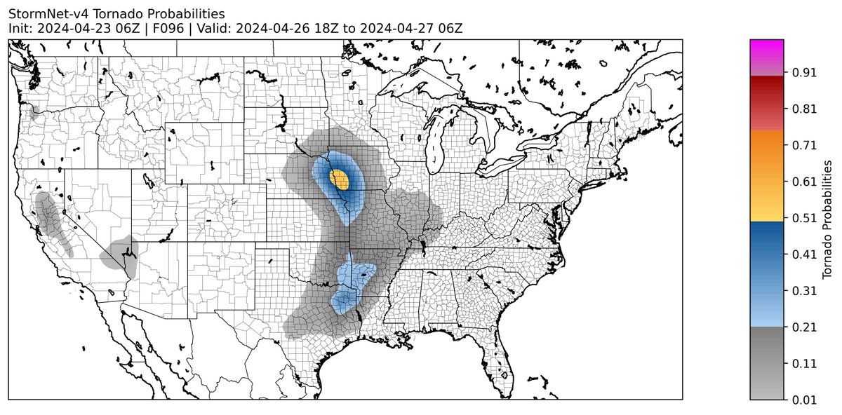
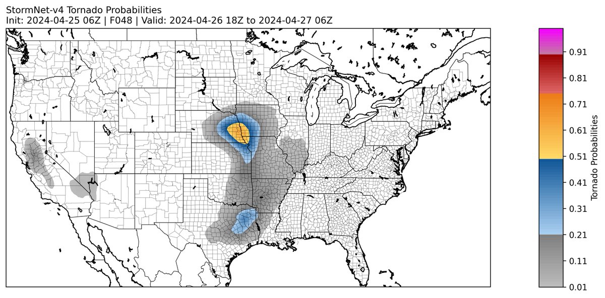
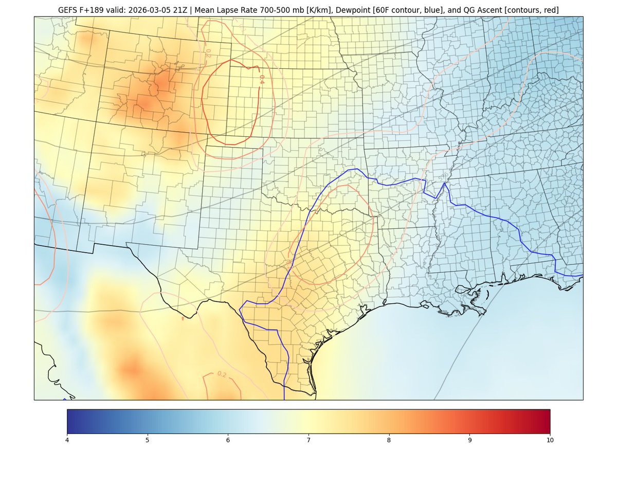
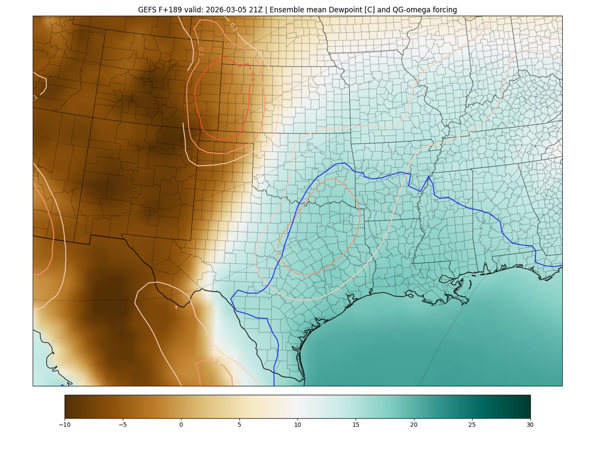
I just reviewed the April 26, 2024 tornado outbreak, and I must say, I'm still gobsmacked: 60 tornadoes, including six that were strong to violent. But the most astonishing thing was the low death toll -- one. Absolutely horrible. But it could have been much worse.

English
2
4
49
5.8K