ChelseaScott

169 posts

ChelseaScott banner
ChelseaScott

ChelseaScott

@ChelseaPScott

Scientist using remote sensing imagery to view our planet| Research prof at Arizona State University @SESEASU, PhD @Cornell

Tempe, AZ Присоединился Mart 2019
496 Подписки422 Подписчики
ChelseaScott ретвитнул
OpenTopography
OpenTopography@OpenTopography·
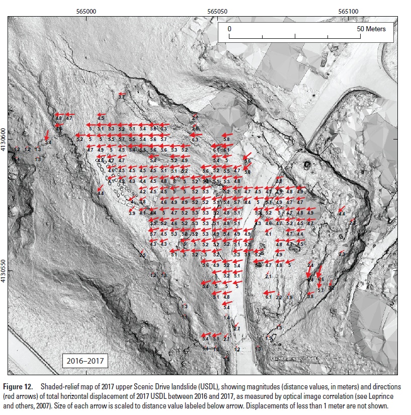
The Governor of CA declared a state of emergency on Sept 3rd due to quickening landslides in Rancho Palos Verdes near LA. Topographic differencing with @NOAADigCoast #lidar in OT shows Earth’s surface change from 2010-2014. The red and blue areas highlight persistent landslides.
OpenTopography tweet media
The New York Times@nytimes

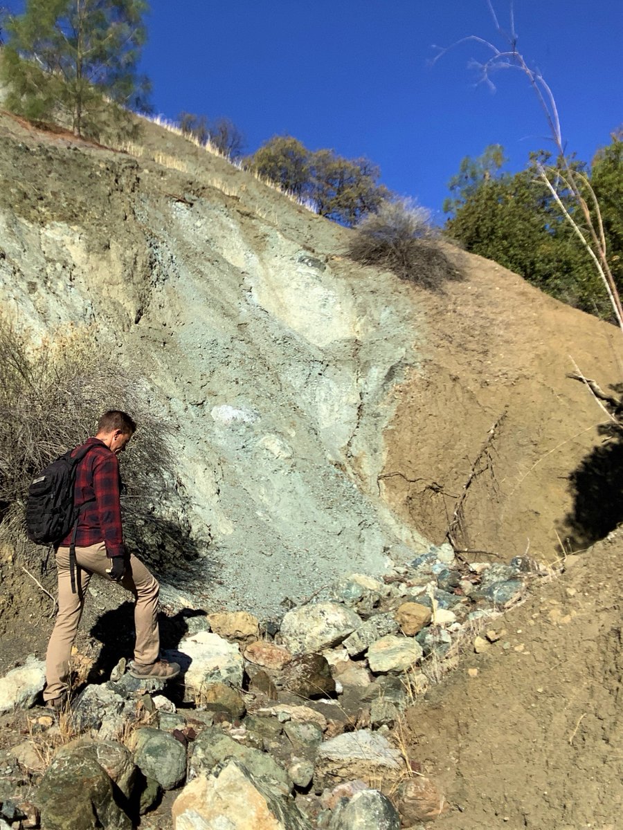
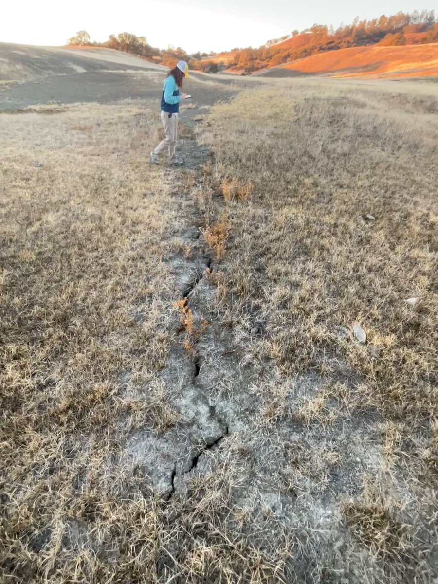
Underneath the multimillion-dollar homes in a scenic town 30 miles south of Los Angeles is a large complex of landslides. Every day, the ground moves. And for some residents, it's been catastrophic. nyti.ms/4cThZR0

English
1
8
17
7.3K
ChelseaScott ретвитнул
OpenTopography
OpenTopography@OpenTopography·
Happy to announce that you can now use OpenTopography tools to compute topographic change on overlapping datasets in the USGS #3DEP & NOAA Coastal Lidar collections. Dynamically compute landscape change for ~20% of CONUS w/ publicly available #lidar in OT: opentopography.org/news/3dep_noaa…
English
0
72
351
37.9K
ChelseaScott ретвитнул
OpenTopography
OpenTopography@OpenTopography·
New OT blog post: "Topographic Change w/ 3D Prints". 3D prints provide a tactile way to explore the Earth’s surface & learn about the geologic processes that shape it. We created 3D prints of pre- & post-event topography from the 2014 Oso, WA landslide: opentopography.org/blog/change-3d…
OpenTopography tweet media
English
2
19
111
14.5K
ChelseaScott ретвитнул
OpenTopography
OpenTopography@OpenTopography·
New study: students use OT to evaluate how well geomorphology-based fault mapping predicted #earthquake surface rupture. For seven past earthquakes, students compared their mapping on pre-event #lidar & imagery with documented ground rupture. Learn more: opentopography.org/blog/mapping-s…
OpenTopography tweet media
English
1
8
26
3K
ChelseaScott ретвитнул
OpenTopography
OpenTopography@OpenTopography·
Nature Reviews Earth & Environment (@NatRevEarthEnv) Tools of the Trade highlight by OT Advisory Committee member @_absrp: "Decoding earthquake mechanics with repeat pass airborne #lidar": rdcu.be/daNyD Many of the repeat lidar datasets highlighted are available via OT.
OpenTopography tweet media
English
0
13
34
4.3K
ChelseaScott ретвитнул
Alba Rodriguez
Alba Rodriguez@_absrp·
Pre-print alert! 👋Introducing a probabilistic displacement hazard assessment framework for distributed ruptures from strike-slip earthquakes on immature faults. We are VERY interested in community feedback, @mikeoskin and I are pretty new to PFDHA! eartharxiv.org/repository/vie…
Alba Rodriguez tweet media
English
11
12
68
9.9K
ChelseaScott ретвитнул
USGS Earthquakes
USGS Earthquakes@USGS_Quakes·
.@USGS_Quakes & @SESEASU are mapping the creeping #SanAndreasfault through rugged ranchlands in central CA. The fault is expressed as sharp rock type and color contrasts in canyons, aligned cracks in parched soil, elongate ridges, and beautiful sheared and striated minerals.
USGS Earthquakes tweet mediaUSGS Earthquakes tweet mediaUSGS Earthquakes tweet mediaUSGS Earthquakes tweet media
English
5
33
165
0
ChelseaScott ретвитнул
OpenTopography
OpenTopography@OpenTopography·
New publication by OpenTopography team member @its_sedimentary et al: "Exploring #TikTok as a promising platform for geoscience communication" (doi.org/10.5194/gc-5-3…). Paper summarizes experiences using the Terra Explore channel as a platform for geoscience communications.
OpenTopography tweet media
English
2
7
24
0
ChelseaScott
ChelseaScott@ChelseaPScott·
@OpenTopography @geophys_xtian LibICP is actually C++ code. I have not found ICP code in python that works well for these Earth Science applications. See our full discussion on ICP algorithms in that linked paper.
English
0
0
3
0
OpenTopography
OpenTopography@OpenTopography·
New tutorial video: 3D Topographic Differencing in #Matlab by @ChelseaPScott: youtu.be/NtS82yQIITA Learn how to measure 3D displacements from high resolution #lidar topography using an example from the 2016 Kumamoto, Japan, Earthquake.
YouTube video
YouTube
English
2
5
24
0