Portage Prepares

8.7K posts

Portage Prepares banner
Portage Prepares

Portage Prepares

@PortagePrep

Education for citizens prepare for weather, disasters, health emergencies & be a resource to recover. Public Comment Policy: https://t.co/cuITQ5i89n

Portage County, Ohio Присоединился Ağustos 2013
355 Подписки609 Подписчики
Portage Prepares ретвитнул
Ohio Turnpike
Ohio Turnpike@OhioTurnpike·
#OHTPK Alert- Traffic Accident WB MP 197 (Portage)- Click link for details ow.ly/Hjh3T
English
1
2
0
753
Portage Prepares
Portage Prepares@PortagePrep·
HELICOPTER RECOVERY INCIDENT AT MOGADORE RESERVOIR. Responders from multiple communities on site in Suffield, Portage Co where helicopter crashed into Mogadore Reservoir this am. No report yet about survivors but recovery is underway. Sunnybrook Rd closed. #PortagePrepares
English
0
1
0
202
Portage Prepares ретвитнул
Ohio Turnpike
Ohio Turnpike@OhioTurnpike·
The Page Road bridge – over the Ohio Turnpike – in Streetsboro at milepost 189.2 in Portage County is currently closed in both directions because of an over-height commercial vehicle strike. The bridge will remain closed overnight, until a signalized closure is in place to reopen Page Road to traffic in both directions.
Ohio Turnpike tweet media
English
0
1
4
1.7K
Portage Prepares ретвитнул
NWS Cleveland
NWS Cleveland@NWSCLE·
Extreme Cold Warning in effect from 7pm Tuesday to 10am Wednesday. Wind chill values will drop overnight and range from 20 below to 26 below zero by early Wednesday morning. #ohwx #pawx
NWS Cleveland tweet mediaNWS Cleveland tweet media
English
1
51
117
14.3K
Portage Prepares ретвитнул
NWS Cleveland
NWS Cleveland@NWSCLE·
3:15 PM EST 1/17/25: Extreme Cold Watch for all of N'ern OH and NW PA for this Mon AM thru Wed AM. Coldest wind chills should reach -15F to -25F during each of those three days. Stay tuned to weather.gov/cle for forecast updates. #OHwx #PAwx
NWS Cleveland tweet media
English
4
42
125
18.5K
Portage Prepares ретвитнул
ODOT Akron
ODOT Akron@ODOT_Akron·
6:15 AM: Light snow moving across the area this morning. Roads are running well at this hour; however, snow is expected to continue throughout the day and those conditions will likely change. More than 100 snowplows are out in District 4. Please give them room to work.
ODOT Akron tweet mediaODOT Akron tweet mediaODOT Akron tweet mediaODOT Akron tweet media
English
0
4
10
1K
Portage Prepares ретвитнул
NWS Cleveland
NWS Cleveland@NWSCLE·
Steady light snow ❄️❄️❄️will move in late today through early Saturday morning. 2 to 4 inches of snowfall expected. Travel impacts possible tonight on untreated and unplowed roads. Scattered light lake effect snow showers will continue for the Snowbelt on Saturday. #OHwx #PAwx
NWS Cleveland tweet media
English
2
27
75
11.5K
Portage Prepares ретвитнул
ODOT Akron
ODOT Akron@ODOT_Akron·
TRUMBULL COUNTY: I-80 eastbound just west of US 62 is currently closed due to a crash. Motorists should avoid the area.
GIF
English
0
3
7
2.2K
Portage Prepares ретвитнул
NWS Cleveland
NWS Cleveland@NWSCLE·
Lake effect snow will be the main focus through Thursday. However, as colder air arrives to ring in 2025 much of the area will see scattered snow showers this afternoon and this evening. Lake effect lulls later Thursday and Thursday night before resuming Friday. #OHwx #PAwx
NWS Cleveland tweet mediaNWS Cleveland tweet media
English
0
15
62
6.9K
Portage Prepares ретвитнул
NWS Cleveland
NWS Cleveland@NWSCLE·
Today will be cloudy with a 20-40% chance of light rain showers arriving from the southwest this afternoon into tonight. A mild stretch of weather is on the way to end the year. Wishing you a happy and safe holiday from the National Weather Service!
NWS Cleveland tweet media
English
1
11
44
4.4K
Portage Prepares ретвитнул
NWS Cleveland
NWS Cleveland@NWSCLE·
Temperatures will trend gradually warmer this week. Expect clouds to linger but only low chances of precipitation or light drizzle through Thursday.
NWS Cleveland tweet media
English
0
8
33
4.3K
Portage Prepares ретвитнул
88.9/WSTB, Weather Center
88.9/WSTB, Weather Center@889weather·
TUESDAY - Cloudy skies with periods of drizzle or light rain. High 37° — TONIGHT - Continued cloudy, but a good night for on-time Santa deliveries! Low 30°
English
0
1
1
52
Portage Prepares ретвитнул
88.9/WSTB, Weather Center
88.9/WSTB, Weather Center@889weather·
MONDAY - Brief morning sunshine, then becoming breezy with increasingly cloudy skies in the afternoon. A mix of rain, snow, and sleet is likely toward evening. High 38° — TONIGHT - Cloudy with a mix of rain and snow. Low 33°
NWS Cleveland@NWSCLE

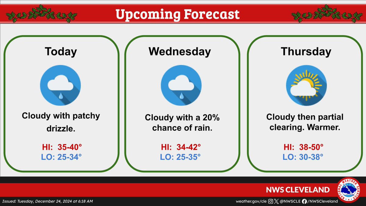
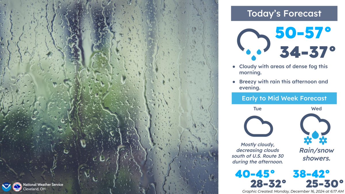
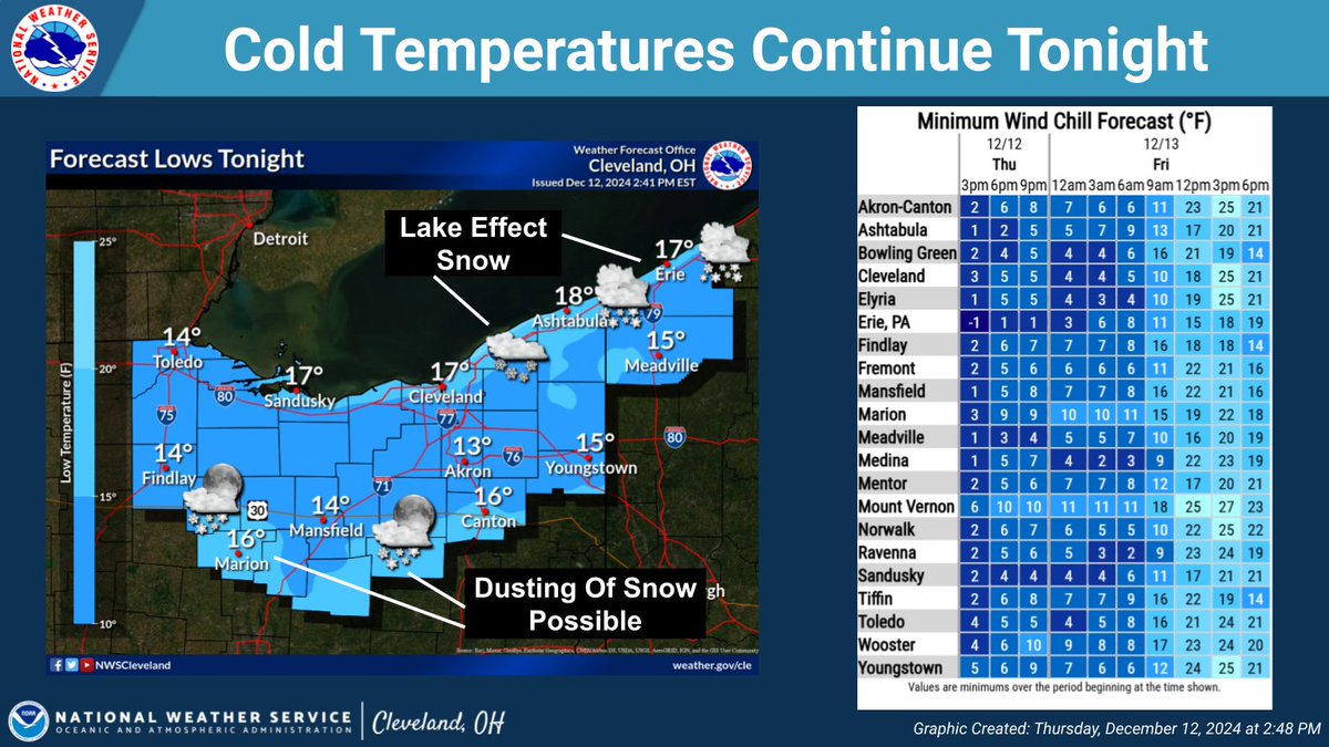
🌧❄ A system will track east through the Great Lakes later today into Tuesday, bringing rain and snow to the area. A quick 1 to 2 inches of wet snow are possible across portions of NE OH and NW PA tonight into Tuesday morning while rain or a rain/snow mix is expected elsewhere.

English
0
1
1
105
Portage Prepares ретвитнул
NWS Cleveland
NWS Cleveland@NWSCLE·
Dry weather is expected today, but rain and snow showers will return Wednesday. Temperatures gradually decrease through the rest of the workweek with highs in the 30s expected by Thursday. To view the forecast for your location, visit weahter.gov/cle
NWS Cleveland tweet media
English
1
8
27
4.4K
Portage Prepares ретвитнул
NWS Cleveland
NWS Cleveland@NWSCLE·
Fog this morning will give way to rain this afternoon and evening. Dry weather returns for Tuesday, but precipitation chances will once again increase for Wednesday. Highs will be mild in the 50s today, but expect temperatures to gradually decrease through mid week. #ohwx #pawx
NWS Cleveland tweet media
English
0
14
44
5.4K
Portage Prepares ретвитнул
NWS Cleveland
NWS Cleveland@NWSCLE·
Rain will continue to spread east across the area this morning. A brief period of freezing rain is likely across NE Ohio and NW Pennsylvania before transitioning to rain as temperatures warm. Travel could be hazardous, especially on bridges, overpasses, and untreated sidewalks.
NWS Cleveland tweet media
English
0
15
46
5.9K
Portage Prepares ретвитнул
NWS Cleveland
NWS Cleveland@NWSCLE·
Lake effect snow will return to extreme Northeast OH and Northwest PA tonight (after a brief break this evening) where another few inches is possible. A dusting of snow is also possible along the route 30 corridor, though confidence is lower. It'll be cold everywhere. #OHwx #PAwx
NWS Cleveland tweet mediaNWS Cleveland tweet media
English
0
17
58
7K
Portage Prepares ретвитнул
88.9/WSTB, Weather Center
88.9/WSTB, Weather Center@889weather·
THURSDAY-A slight chance of a few morning flurries or snow showers with skies becoming partly sunny. Windy, and cold throughout the day with wind chills in the single digits. High around 20° — TONIGHT - Partly cloudy skies. Low 15°
English
0
2
1
62