Naka-pin na Tweet
Michael T
52.9K posts


Michael T
@BigMikeXT
Tech lover; Breaking News; Dodgers fan, USAF Veteran 🇺🇸
Houston, TX Sumali Mayıs 2009
760 Sinusundan524 Mga Tagasunod
Michael T nag-retweet

WIN $5000
@BedBathBeyond @ContainerStore @kirklands @AskTheInstaller @CabinetsToGo shopping spree
Must RT and use
#BedBathandBeyond
English
Michael T nag-retweet
WIN $5000
@BedBathBeyond @ContainerStore @kirklands @AskTheInstaller @CabinetsToGo shopping spree
Must RT and use
#BedBathandBeyond

English
It was fun. When I was a kid we had 11 houses on the same type of street. And 1 summer evening every year we would block the street off and have a party with all 11 houses. This was back in the 80s and 90s.
HOUSE PORN@HOUSEPORN___
I don't think that's a good idea 😭
English
Michael T nag-retweet


Michael T nag-retweet

It’s wild how 3 deaths from Hantavirus got more media attention than 50,000+ people in Venezuela are missing!

English
Michael T nag-retweet

NEW: National Hurricane Center draws an official “low” (20%) chance for tropical development off the coast of Georgia over the next 7 days.
Talking though more specifically about next Tuesday / Wednesday timeframe.
A cluster of thunderstorms passing by Chicago and the Midwest will zoom SE towards the Atlantic coast early next week. When it gets to the ocean, it will stop along a front and may spin up into a tropical system.
Odds are fairly low this actually happens. The only model that really suggests continues to be the cutting edge Google “DeepMind” AI modeling. AI weather modeling is different than traditional physics based weather models. They are “trained” on historical weather events and told to compare essentially solely to those.
Second image shows the Google model with an insistently strong signal for “Bertha” to form mid-next week, tracking into Georgia or NE Florida.
Impediments to development; dry air, low moisture, and limited window over water. But, water temps are historically hot off the FL and GA east coast, and that is one of the few spots this hurricane season with lower wind shear, not impacted by the negating impacts of strong El Niño across the rest of the basin.
For central Florida, I don’t see much chance at this time this is any notable impact to the Orlando area? If it formed into anything. It would either go into Georgia or get pushed back out to sea away from Florida next week.
Regardless, still expect high daily rain and storm coverage in east flow Monday-Wednesday next week in central FL.
AI models insist on tropical storm Bertha. Conventional wisdom says it’s a very long shot. We will watch in the coming days and see who’s right this time.


English
Michael T nag-retweet

WATCH: Debris falls after small plane crashes into the CITIC Tower in Beijing
English
Michael T nag-retweet


Michael T nag-retweet


Michael T nag-retweet


Michael T nag-retweet
BREAKING: Pacific Tsunami Warning Center issues tsunami alert for Venezuela and nearby islands after 7.1 quake
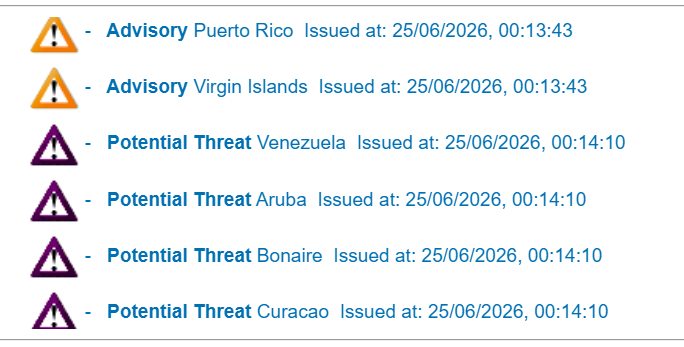
English
Any streaming service should do this
Lyn🦋@_ayandamay
Netflix, quit putting my Continue Watching 4-5 rows down. It should be in the first row.!!!!
English
Michael T nag-retweet

Flash Flood Emergency confirmed by law enforcement in Bentley and Caney, Oklahoma — 4 to 7 inches already down with more coming. Get to higher ground right now, do not get in a vehicle unless you're fleeing.

English