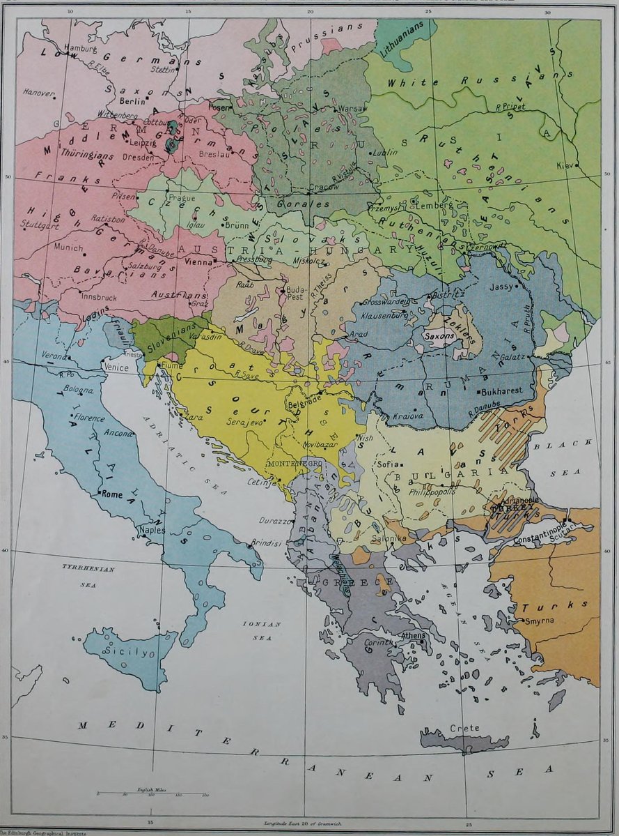
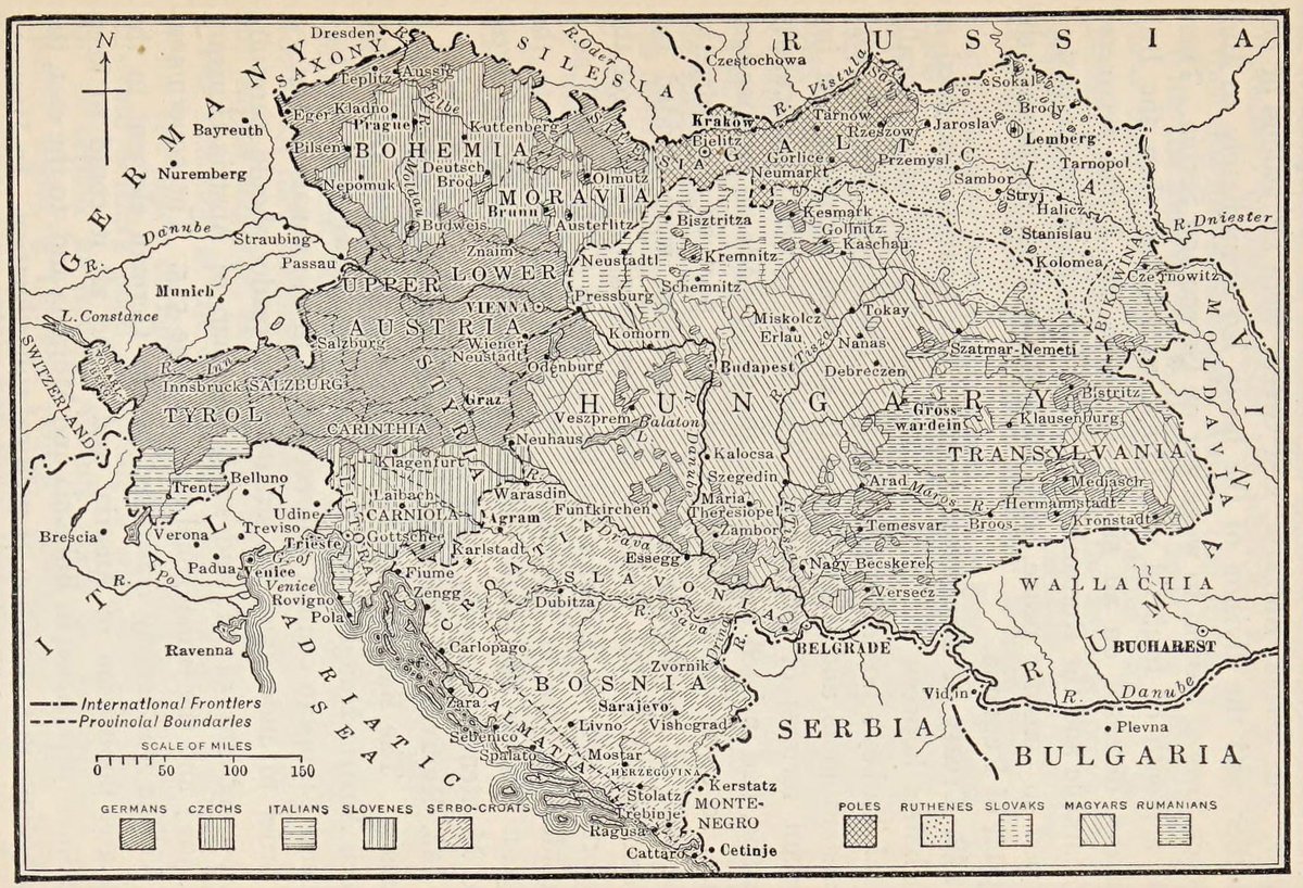
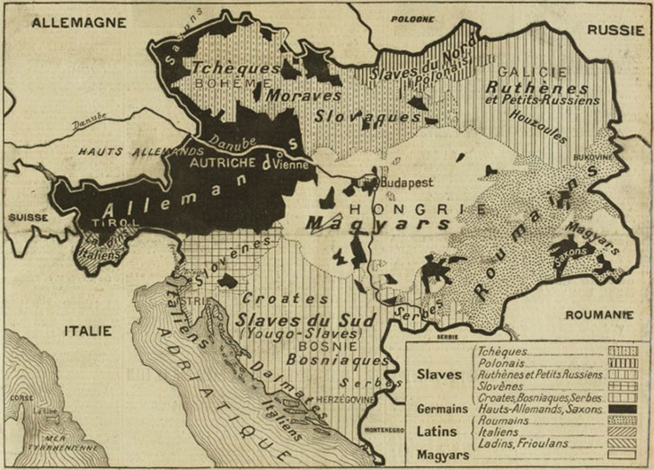
Edmaps.com

2.3K posts

Edmaps.com banner
Edmaps.com

Edmaps.com

@EdmapsCom

Putting the World on the Map: History - Political Geography - Borders - Lands - Maps

Montreal, Canada Sumali Şubat 2015
293 Sinusundan3K Mga Tagasunod
Edmaps.com
Edmaps.com@EdmapsCom·
Old school history maps: The French colonial empire, ca. 1930 (« La place et la répartition des colonies françaises ») #map #carte #France
Edmaps.com tweet media
Français
0
0
3
156
Edmaps.com
Edmaps.com@EdmapsCom·
History, maps and nationalities: Ethnographic Map of Central Europe and the Balkans, 1914 (“Austria-Hungary and Balkans States - Ethnographical,” from C. Grant Robertson & J. G. Bartholomew, An Historical Atlas of Modern Europe from 1789 to 1914, Oxford University Press, London, 1915) #history #historical #map #atlas #ethnographic #war #WWI #Europe #Germany #Austria #Russia #Ukraine #Poland #Romania #Hungary #Moldova #Slovakia #Bulgaria #Greece #Croatia #Serbia #Italy #Türkiye #Albania #Czechia #Lithuania
Edmaps.com tweet media
English
0
0
3
163
Edmaps.com
Edmaps.com@EdmapsCom·
History, cars, and maps: Downtown Toronto featuring points of interest, parks and principal buildings, 1936 (a “Shell map,” made by the H.M. Gousha Company & printed in Canada) #street #road #city #map #downtown #Toronto #Ontario #Canada #Gousha #USA #RandMcNally The story of the H.M. Gousha Company begins with an act of bold independence. Harry Mathias Gousha (1892–1970) had built his career at Rand McNally, joining as a sales manager in 1918, before leaving in 1926 to launch his own map publishing venture in Chicago. It was a gamble that paid off almost immediately. The company quickly secured contracts to produce millions of road maps for oil companies, freely distributed at gas stations by major clients including Gulf Oil, Conoco, and Standard Oil. One of Gousha's early signature offerings was the “Touraide,” a spiral-bound travel book combining road maps, points of interest, and accommodations, custom assembled for individual buyers — setting the company apart from its rivals. Alongside Rand McNally and the General Drafting Company, Gousha rose to become one of the dominant “Big Three” U.S. road map publishers. The firm relocated to San Jose, California in 1946, was acquired by the Times Mirror Company in 1963, and later established a production facility in Comfort, Texas in 1966. A turning point came with the Arab oil embargo of 1973–74. Oil company publishing contracts were greatly reduced, and to offset these losses, Gousha pivoted to retail maps and travel guides under its own imprint, most notably the Chek-Chart series. The company also introduced Fastmap, one of the first lines of laminate-encapsulated maps. The company was bought by Simon & Schuster in 1987, before its story came full circle. On the morning of April 18, 1996, Gousha's 82 employees arrived at their Comfort, Texas facility to find the building locked, with a note on the door announcing the company had been purchased by Rand McNally — the very firm Harry Gousha had left seven decades earlier. The Gousha artwork and archives were ultimately donated to the Newberry Library in Chicago, where the legacy of one of America's great cartographic enterprises is preserved to this day.
Edmaps.com tweet media
English
0
0
2
116
Edmaps.com
Edmaps.com@EdmapsCom·
History, maps, and U.S. borders: ''The U.S. Western Boundaries: The Rayneval Memorandum (September 1782)'' (for a larger map: usamaps.edmaps.com/map_united_sta…) #USA #borders #France #war In September 1782, as diplomats gathered in Paris to negotiate an end to the American Revolutionary War, France presented a proposal that would have dramatically reshaped the territorial future of North America. The Rayneval memorandum, named after French diplomat Joseph Matthias Gérard de Rayneval, outlined boundaries for the nascent United States that were far more restrictive than what American negotiators sought or would ultimately achieve. France's vision reflected its desire to balance power on the continent while satisfying its Spanish ally. The proposal would have confined the United States to a relatively narrow band along the Atlantic coast, extending westward only to the Appalachian Mountains or, at most, to a line considerably east of the Mississippi River. The Ohio River would serve as the northern boundary, beyond which the Province of Quebec—retained by Britain—would maintain its extensive territorial claims southward. The most striking feature of the French proposal was the creation of vast Indian territories in the continental interior. These lands, situated between the Appalachians and the Mississippi River and south of the Ohio River, would be designated as autonomous Native American territories under the joint protection of Spain and the United States. This arrangement aimed to create a buffer zone that would limit American expansion westward while acknowledging Indigenous sovereignty—though under European supervision. France's motives were complex. As America's crucial wartime ally, France sought to ensure British defeat, but not necessarily American dominance. The proposed boundaries would create a weaker United States dependent on French goodwill, while strengthening Spain's position in North America. Spain, which controlled Louisiana and Florida, feared aggressive American expansion toward its territories and favored substantial Native American buffer states. American negotiators, particularly John Jay and Benjamin Franklin, viewed these proposals with alarm. They recognized that accepting such boundaries would strangle the new republic's growth and trap it along the eastern seaboard. Through skillful diplomacy—including separate negotiations with Britain that technically violated their alliance with France—the Americans ultimately secured far more generous terms in the 1783 Treaty of Paris. The final agreement established the Mississippi River as the western boundary, the Great Lakes region as the northern frontier, and incorporated the vast territory south of the Great Lakes and north of Florida into the United States, laying the foundation for future westward expansion and rendering the French vision of protected Indian territories largely moot.
Edmaps.com tweet media
English
0
0
5
162
Edmaps.com
Edmaps.com@EdmapsCom·
History, Kurds, and Maps: ''Map showing approximate distribution of Kurdish tribes of the Ottoman Empire,'' ca. 1900 (from Mark Sykes, The Kurdish Tribes of the Ottoman Empire, The Journal of the Royal Anthropological Institute of Great Britain and Ireland, 1908, vol. 38, p. 451-486) Mark Sykes is the guy from the Sykes-Picot Agreement... #historical #history #map #Kurds #Kurdistan #Turkey #Turkish #Türkiye #Iran #Iraq #Syria
Edmaps.com tweet media
English
0
0
3
205
Edmaps.com
Edmaps.com@EdmapsCom·
History, Iranian Kurds and Maps: Republic of Mahabad The Kurdish Republic of Mahabad, proclaimed on January 22, 1946, in northwestern Iran, represents a singular episode in modern Kurdish history: the only instance in which an independent Kurdish state was constituted and briefly sustained in the contemporary period. Its emergence, brief existence, and rapid dissolution illuminate the intersection of minority nationalism, imperial rivalry, and the fragility of peripheral political formations in the post-war international order. The conditions that made the republic possible were rooted in the particular circumstances of wartime Iran. Following the Allied occupation of the country in 1941, Soviet forces stationed in the northwestern provinces actively cultivated the political aspirations of non-Persian minorities, including the Kurdish population concentrated around the city of Mahabad. This external patronage intersected with an indigenous political awakening that had been gathering momentum since the early 1940s. The clandestine organization Komala, founded in 1942, brought together Kurdish intellectuals and urban notables around a program of cultural and political emancipation. By 1945, Komala had evolved into the Kurdistan Democratic Party, which became the institutional vehicle through which the republic was proclaimed. The leadership of the republic fell to Qazi Muhammad, a member of a prominent judicial family whose social prestige and reputation for probity made him an effective symbol of Kurdish aspirations. Under his presidency, the republic undertook a series of institution-building measures: Kurdish was established as the language of administration and education, a press was founded, and a modest military force was organized. The presence of Mustafa Barzani, the Iraqi Kurdish leader who had sought refuge in Iran with several hundred fighters, gave the republic's armed wing a degree of military experience it would otherwise have lacked. Yet the republic remained territorially confined, economically dependent, and politically divided between nationalist urban elites and tribal leaderships whose allegiance to the new state was never unconditional. The structural vulnerabilities of the republic were ultimately less decisive than the geopolitical shifts that deprived it of external support. In 1946, under significant Anglo-American pressure and in exchange for oil concessions from Tehran, the Soviet Union withdrew its forces from Iranian territory. This withdrawal condemned both the Azerbaijani People's Government to the north and the Kurdish republic to the south. Without Soviet protection, neither formation could withstand the reassertion of Iranian central authority. Government troops entered Mahabad in December 1946, meeting no sustained resistance. In March 1947, Qazi Muhammad and several of his associates were executed by hanging in the city's main square. The republic had endured for approximately eleven months. Historians have debated the degree to which it constituted a genuinely popular national movement as opposed to an instrumentalized product of Soviet regional policy. The evidence suggests both dimensions were present simultaneously: real Kurdish nationalist sentiment, channeled and amplified by external patronage, producing an entity that was neither purely artificial nor durably autonomous. What remained after its dissolution was a powerful memory — the republic entered Kurdish political mythology as proof that statehood, however briefly, had once been achieved, a precedent invoked repeatedly in the decades that followed. #Iran #Kurdistan #Kurds #Kurdish #State #historical #map #maps
Edmaps.com tweet mediaEdmaps.com tweet media
English
0
0
3
176
Edmaps.com
Edmaps.com@EdmapsCom·
Africa, History, and Maps: South Africa in 1894 (Map of ''Southern Africa, showing the Cape Colony, Natal, Orange Free State, South African Republic, Basutoland, Zululand, Bechuanaland, Zambesia, German South-West Africa, etc.''; from Alexander Wilmot, The Story of the Expansion of Southern Africa, T. Fisher Unwin, London, 1894) #history #Historical #map #maps #Africa #SouthAfrica #CapeTown #Pretoria #Zimbabwe #Namibia #Zambia #Botswana #Mozambique #Angola @elonmusk
Edmaps.com tweet media
English
0
0
2
107
Edmaps.com
Edmaps.com@EdmapsCom·
@vithimerius The map presented a French view: it was made and published by Excelsior, a French journal.
English
1
0
0
21
Leo Ruthenorum
Leo Ruthenorum@vithimerius·
@EdmapsCom Officially, there were no Little Russians in Galicia. People who identified as Rusyny in Austria-Hungary were labeled with the exonym "Ruthenians", whereas in the Russian Empire they were labeled "Little Russians". Hutsuls constituted just one of their ethnographic groups.
English
1
0
0
43
Edmaps.com
Edmaps.com@EdmapsCom·
History, nations, and #maps: Ethnographic map of Austria-Hungary, 1918, from Excelsior (#Paris), June 27, 1918. When Eastern Galicia was divided between Ruthenians, Little Russians and Hutsuls... #map #carte #French #newspaper #journal #history #historical #nationalism #nationalities #war #WWI #ethnographic #CentralEurope #mitteleuropa #Austria #Hungary #Germany #Ukraine #Galicia #Russia #Poland #Romania #Slovakia #Serbia #Croatia #Czechia #Slovenia #France #Germany
Edmaps.com tweet media
English
1
0
6
251