Theresa Key nag-retweet
Theresa Key
4.3K posts


Theresa Key
@Tesa
“Life is a shipwreck, but we must not forget to sing in the lifeboats.”. Voltaire
Benton, Arkansas USA Sumali Temmuz 2007
2K Sinusundan790 Mga Tagasunod

Theresa Key nag-retweet

Prepare for some extreme weather whiplash this week in Arkansas, at least from a temperature perspective.
High temps today will be mainly in the 60s and 70s, and after a strong cold front moves through late this afternoon, we'll crash into the 20s and 30s tonight. High temps will only reach the 30s & 40s on Monday, with 40s and 50s on Tuesday.
By the end of the week, most locations will be in the 80s. Lows will fall into the teens and 20s to start the week, with mostly 50s or low 60s to end the week.
March is normally a month of transition when Arkansas moves from winter to spring, and next week will certainly hold true.
Gusty winds today, tonight, and Monday will add to the chill. Wind gusts in northern and NW AR may approach 50 mph at times, with most other areas in the 35-40 mph range.
Watch for severe weather today as a rather thin but potent line of thunderstorms will blast across the state later today. #arwx
English
Theresa Key nag-retweet
Central Arkansas Winter Weather Outlook
WINTER STORM WARNING!
EXTREME COLD WARNING!
Issued: January 23, 2026, 7:00 AM
Overview
A high‑impact winter storm is expected to affect all of Arkansas from Friday evening through Sunday mid-day, bringing moderate to heavy amounts of sleet, snow and at times, freezing rain. Dangerous arctic cold temperatures will also be a concern.
What to Expect
❄️ Precipitation
•Primary type (Central Arkansas):Sleet — moderate to heavy.
•Additional types: Pockets of snow or freezing rain at times.
•Accumulation forecast:
◦3–5 inches of sleet/snow
◦Locally higher totals possible
◦Freezing rain mainly amounts of 0.10 -0.25” locally higher amounts possible.
◦Gusty NE winds at time up to 30 mph.
🕒 Timing
•Starts: Friday evening (~7 PM)
•Ends: Sunday midday
•Heaviest period: Friday night → Saturday night
🌡️ Cold Temperatures
•Low temps: Single digits to teens statewide. Wind chill values near or below zero.
•High temps: Very little warming during the day
•Duration: 72–84+ hours below freezing
•Monday morning lows: Near 0°F in Little Rock; colder where snow/ice is deepest
⚠️ Impacts
•Hazardous / impossible travel conditions
•Risk of power outages (especially where freezing rain occurs)
•Frostbite and dangerous cold conditions
•Emergency preparedness recommended:
◦Avoid travel unless necessary
◦Keep a winter emergency kit in vehicles
🌀 Meteorological Notes (Geeky Stuff)
•Storm system still developing; key factors include:
◦Track of upper-level disturbances
◦Depth of cold surface air
◦Position and strength of the warm nose aloft (determines sleet vs. snow vs. freezing rain)
•Precipitation may start as snow and quickly mix with sleet and freezing rain then continue as a mix of freezing rain/sleet and occasionally snow Friday nightthrough early Sunday.
•Model trends towards a changeover to snow on the backside of the system on Sunday morning into the afternoon before ending.
•Low temperatures will be near zero in Little Rock on Monday morning and single digits Tuesday morning. Areas that receive higher amounts of frozen precipitation may drop below zero.
•Total water equivalent for all precipitation types for this event may be in the 1 – 1.5” range.
Michael Hook
English
Theresa Key nag-retweet
The northern model trend continues. As of now, central AR could conceivably get very little snow with the main precipitation type being either sleet or freezing rain. It’s still 3 days out but the heaviest snow is trending into northern AR with significant icing in central and southern. Stay tuned. The atmosphere is dynamic. #arwx
English
Theresa Key nag-retweet

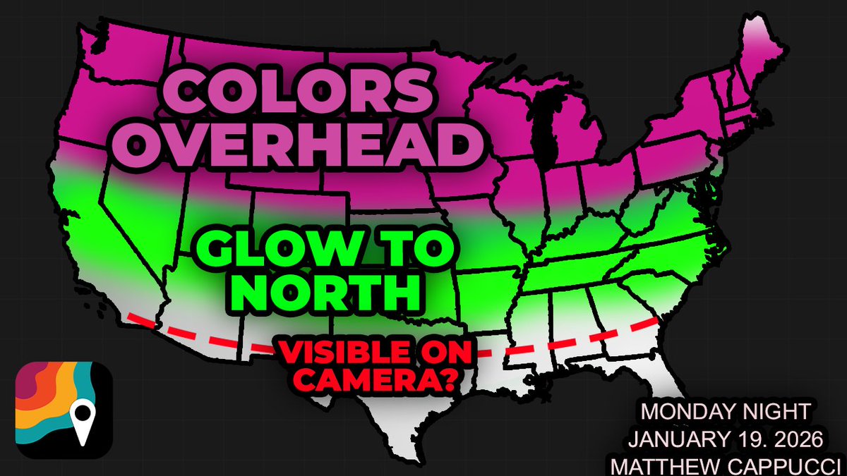
UPGRADE! A SEVERE or G4 geomagnetic storm is now predicted by the Space Weather Prediction Center ! This *could* bring widespread auroral displays to the United States *if* things ensue as modeled. This is anticipated TONIGHT, Monday night, January 19!
We are awaiting a magnetic shockwave called a CME, or coronal mass ejection. A NASA model shows the CME may be stronger, and faster, than originally modeled, meaning it could slam Earth's magnetic field around 8 p.m. Eastern time Monday night. That impact will spark auroral displays.
The northern U.S. may see some colors overhead, primarily green and/or purple, whereas areas to the south might notice a reddish or green glow on the northern horizon. The colors won't appear quite as vibrant to your eyes as they do on camera, but an impressive display remains possible.
NOTE: there remains uncertainty regarding the timing, and realistically the impact could ensue any time within 6 hours either side of that time frame.
Also note that, while we believe the CME will hit Earth, a more glancing blow can't be ruled out. That would reduce impacts.
This is all associated with an X2-class solar flare, which launched off the sun around 11:09 a.m. Eastern time Sunday. It originated from sunspot 4341, a large, bruise-like discoloration on the surface of the sun throbbing and pulsating with magnetic energy. It's also a cooler region on the sun's surface.
Solar flares are flashes of light and electromagnetic radiation that expel high-energy particles through space at the speed of light. This particular flare caused a degradation of radio wave propagation and partial radio blackout over western South America and the eastern South Pacific.
The flare was followed by a CME, or coronal mass ejection, accompanied the flare. CMEs are slower waves of magnetism and ejected solar plasma that surf through space like a shockwave. They take a couple days to reach Earth (when they’re Earth-directed). Stronger ones are usually faster.
CMEs interact with Earth’s magnetic field, which transforms potentially harmful energy and magnetism into visible light — the aurora.
This CME is set to reach us within about 36 hours, which is very fast. That means a heftier impact.
Isolated yourself from city lights and find a clear, unobstructed view of the northern horizon. Check the weather forecast first too... and stay tuned here for updates.
Also note that we do NOT HAVE A SPECIFIC TIME. Space weather forecasting is still in its infancy, and timing your observation with the occurrence of an auroral “substorm” is purely a game of luck. 10 p.m. Eastern time/9 p.m. Central may be a good time to attempt viewing.
English
I’m supporting campaigns at the state level and I’ve got my State Supporter badge from @actblue to prove it! Will you join me? secure.actblue.com/my-express/sea…
English
Theresa Key nag-retweet

Theresa Key nag-retweet


@Kenny_Wallace @NASCAR Because they can feel how much you love them. ❤️💕♥️
English
Remembering Tommie Adams: Benton community leader leaves legacy of love, lifelong service bentoncourier.com/news/rememberi… via @SalineCourierSp
English
Theresa Key nag-retweet

☀️💛 The Murdaugh: Death in the Family Official Podcast launches October 15, the same day the scripted Hulu series premieres — featuring special guests Patricia Arquette, Jason Clarke, and Jay Paulson. @mandy_matney
Stay tuned …
📄 Read more:
deadline.com/2025/10/hulu-m…

English
Theresa Key nag-retweet
Saline County Sheriff’s Office investigating shooting incident in Benton. Read the article... mysaline.com/scso-shooting-…

English
KEY WEST BACK IN THE DAY: BUFFETT & ‘THE MARGARITAVILLE MOVIE’ keysweekly.com/42/key-west-ba… via @Florida Keys Weekly Newspapers
English
@Kenny_Wallace @ConnorZilisch To me, the Savannah Banana’s mean joy. They love the game, and they care about the fans, and they want everyone to have as much fun as they do. They are true athletes and they have amazing skill levels….but still manage to not take themselves to seriously.
English
“Coffee with Kenny”
Are the SAVANNAH Bananas better than REAL competition?
Anthony Macri
@ConnorZilisch 🏁🏁
English
Theresa Key nag-retweet

Theresa Key nag-retweet
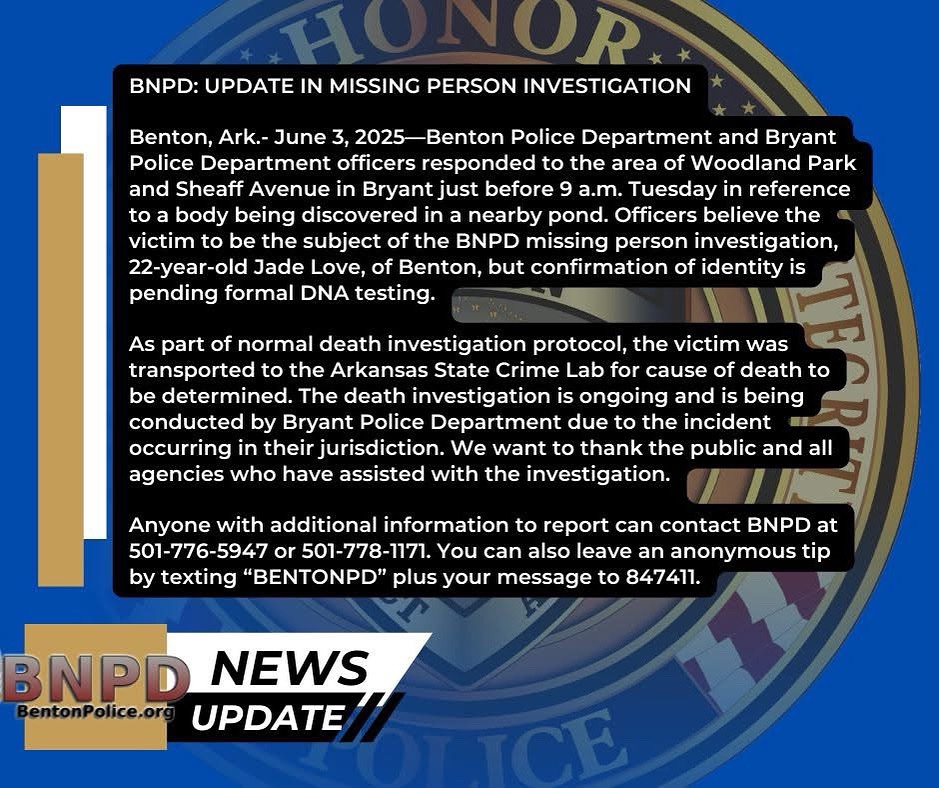
Booby traps at Benton property lead to arrest and bomb squad. Read the full article at... mysaline.com/bnpd-061825/

English
Theresa Key nag-retweet

Anyone with additional information to report can contact BNPD at 501-776-5947 or 501-778-1171. You can also leave an anonymous tip by texting “BENTONPD” plus your message to 847411.
#BNPD #NewsUpdate
English
Theresa Key nag-retweet

@jimmybuffett exhibit taking shape in Mobile - there is a timetable and plans in place for redoing a portion of the National Maritime Museum of the Gulf into a tribute for the "Son of a Sailor," his music and legacy. The latest: al.com/news/2025/05/m…
English
Theresa Key nag-retweet

Responding to a question from @JennaFryer about the Penske firings, @smclaughlin93 says: "Ultimately, those three guys are friends of mine and have done a tremendous amount in my career to get me to this point. So there’s a sadness from my perspective. At the end of the day, I drive for Roger Penske and I respect the decision and I understand the decision and we’ve moved forward. I’m disappointed by some of my peers and people in this room just how it was taken out of proportion in some ways. … Smart people in this paddock know there was no gain with that. It’s frustrating this has blown up like it has and cost three people I’m very close with their jobs."
English