Keith Gibson

33.1K posts

Keith Gibson banner
Keith Gibson

Keith Gibson

@WeatherManKG

Chief Meteorologist at WISH-TV in Indianapolis, IN. Certified Broadcast Meteorologist #73

Indianapolis Sumali Aralık 2010
818 Sinusundan2.9K Mga Tagasunod
Keith Gibson
Keith Gibson@WeatherManKG·
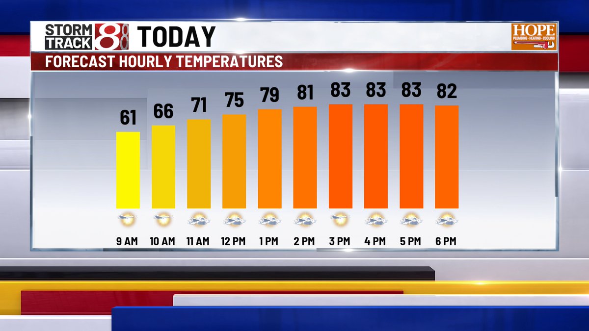
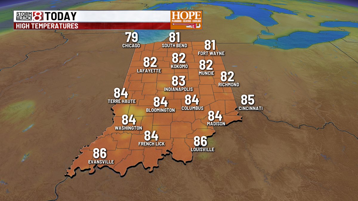
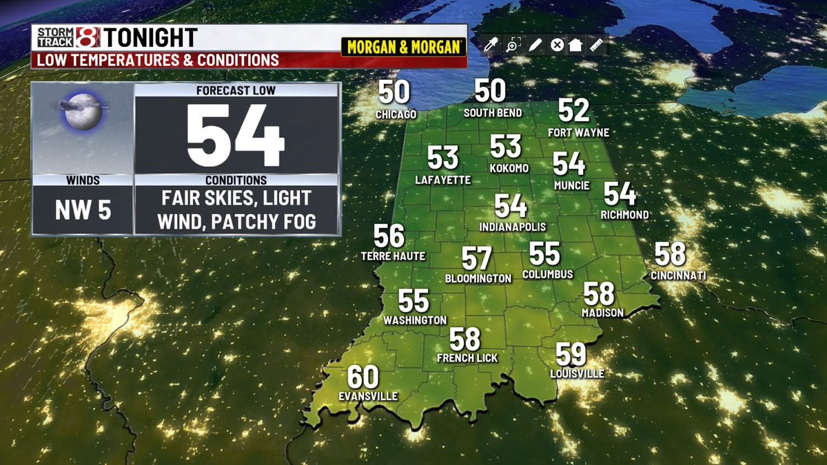
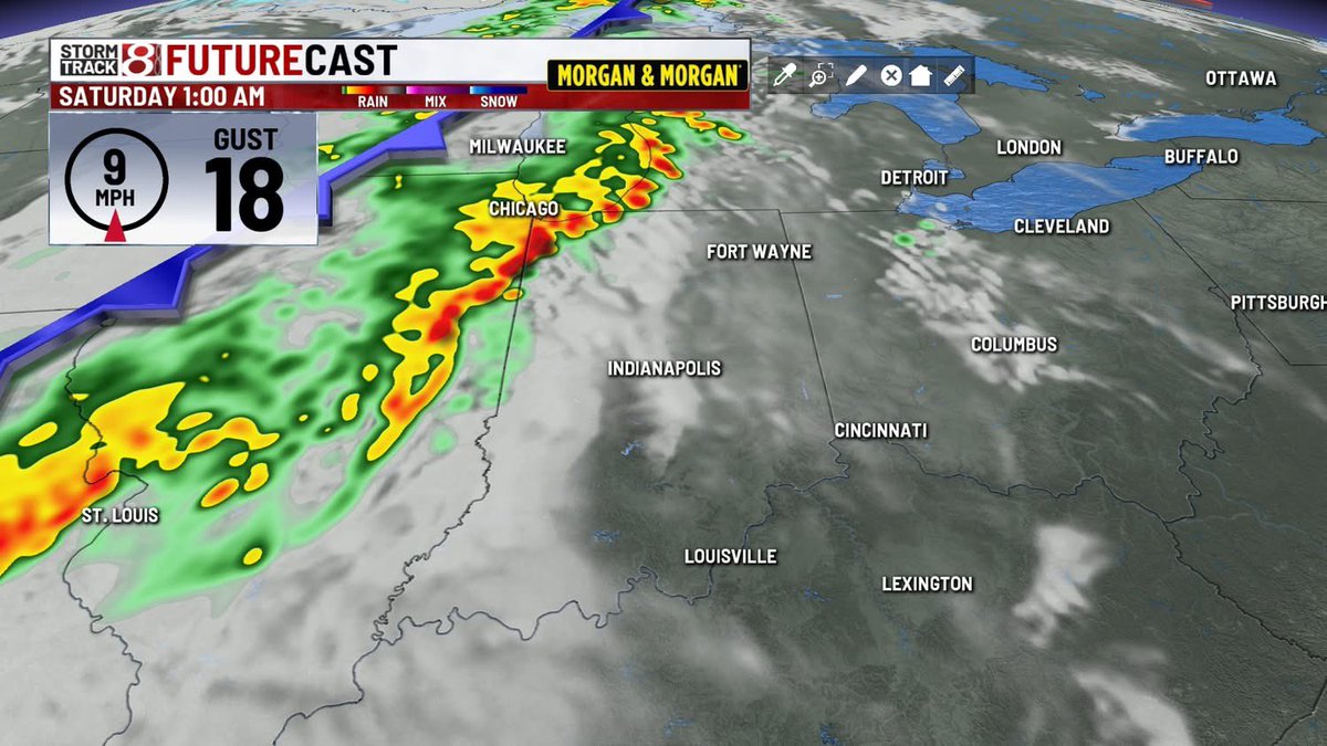
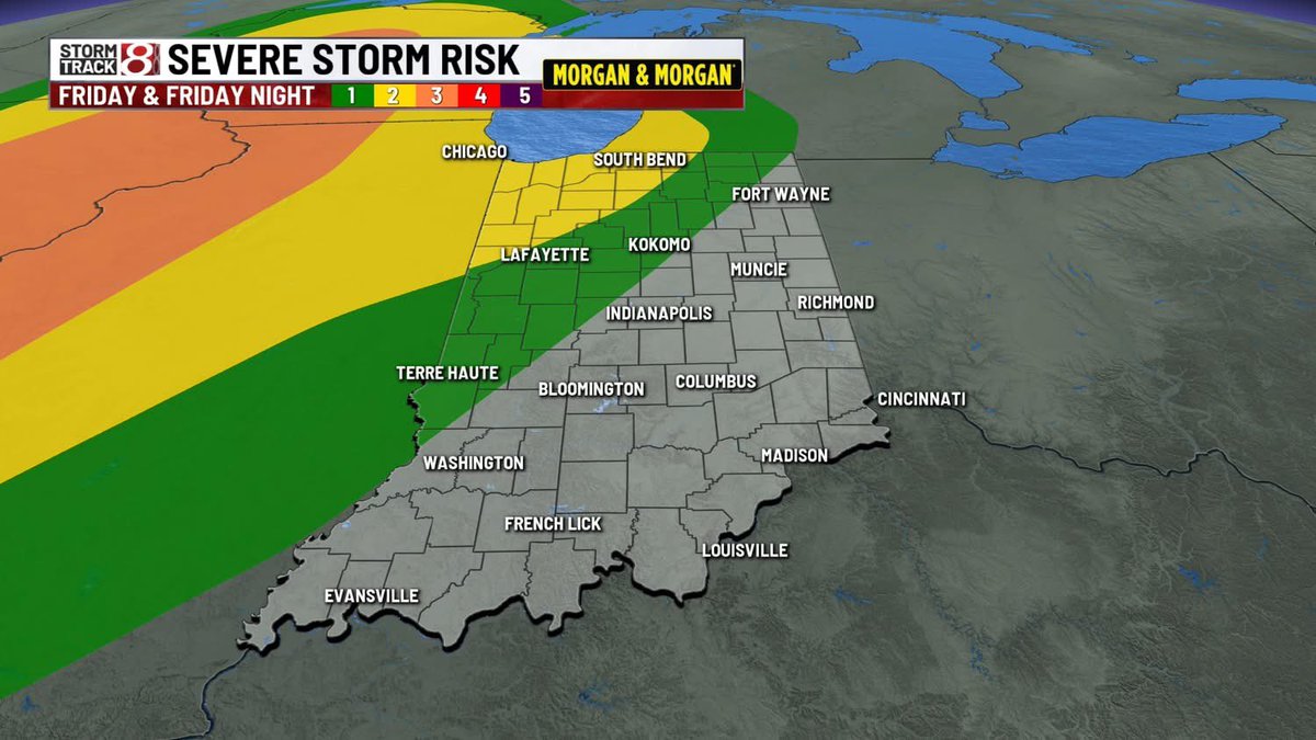
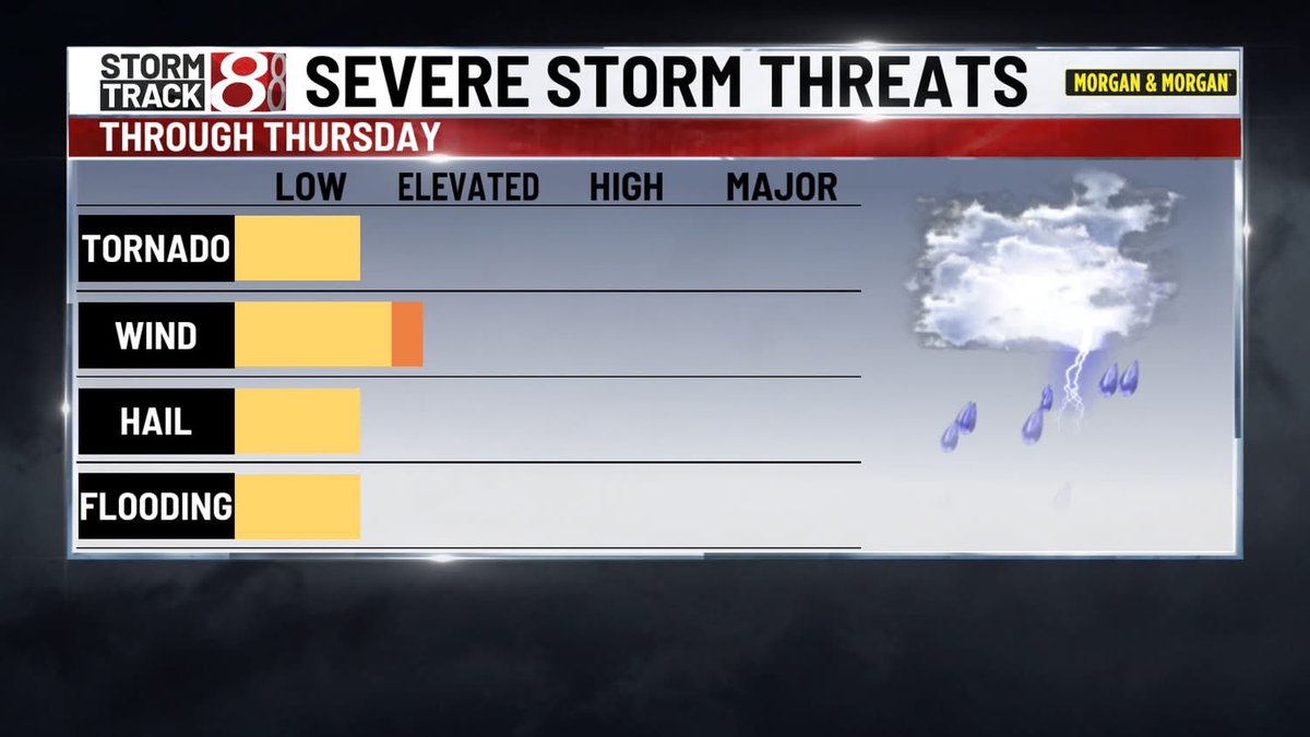
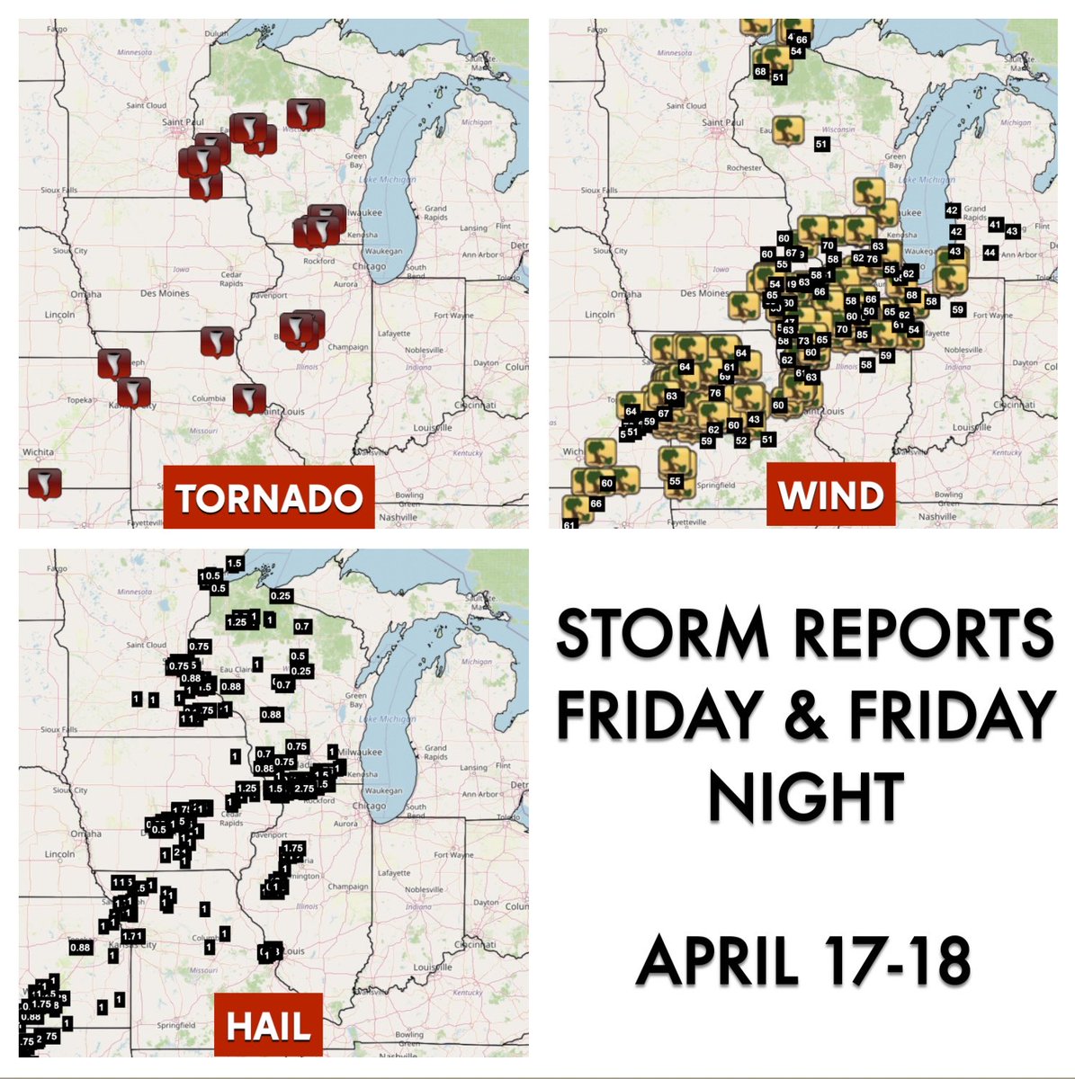
Central Indiana was spared from the worst weather over the last 24 hours… and now we have much cooler air for the weekend behind the cold front that is moving through. #inwx
Keith Gibson tweet media
English
0
0
0
87
Keith Gibson
Keith Gibson@WeatherManKG·
Good looking outflow boundary kicking across Indiana tonight #inwx
English
0
0
0
84
Keith Gibson
Keith Gibson@WeatherManKG·
11:30 PM FRIDAY 4/17: this line of storms moving into Western Indiana may produce wind gusts 50-60 mph. The tornado threat with this line has decrease but it's still worth watching out for in the near term. Storms are moving east about 45 mph. #inwx wishtv.com/weather
Keith Gibson tweet media
English
0
0
0
237
Keith Gibson
Keith Gibson@WeatherManKG·
11 PM FRIDAY 4/17: storms are quickly approaching Western Indiana. These have a history of wind and tornaodes in Illinois but a gradual weakening process is still expected over the next few hours as they move more into Indiana. #inwx wishtv.com/weather
Keith Gibson tweet mediaKeith Gibson tweet media
English
0
1
0
101
Keith Gibson
Keith Gibson@WeatherManKG·
9:40 PM EDT FRIDAY 4/17: a tornado watch has been extended into parts of NW Indiana until midnight. An additional watch expansion could occur later tonight. These big storms are tracking ENE between 40-50 mph and will be near the border by midnight if not a little before. #inwx
Keith Gibson tweet media
English
0
1
0
199
Keith Gibson
Keith Gibson@WeatherManKG·
3:35 PM FRIDAY: humidity is gradually ticking up and that has lead to a few spotty showers west of Indy. Big storms are erupting to our west and some of this will move into Indiana after midnight. #inwx wishtv.com/weather
Keith Gibson tweet mediaKeith Gibson tweet mediaKeith Gibson tweet mediaKeith Gibson tweet media
English
0
1
0
126
Keith Gibson
Keith Gibson@WeatherManKG·
We’ll be watching radar this evening with big storms developing to our west. I expect these to start weakening the farther east they travel into Indiana after midnight. Highest odds of severe potential still look to be NW of Indy. #inwx
Keith Gibson tweet media
English
0
1
1
145
Keith Gibson
Keith Gibson@WeatherManKG·
FRIDAY MORNING - It's a cooler start this morning - but still quite pleasant. near record highs return later this afternoon, as we push into the mid-80s, nearly 20° above average for this time of year. A spotty shower/storm late this afternoon can't be ruled out. #INwx
Keith Gibson tweet mediaKeith Gibson tweet mediaKeith Gibson tweet mediaKeith Gibson tweet media
English
0
0
0
105
Keith Gibson
Keith Gibson@WeatherManKG·
DENSE FOG ADVISORY for Northern Indiana until 8 AM Friday. Visibility 1/4 mile or less could occur overnight. #inwx wishtv.com/weather
Keith Gibson tweet media
English
0
0
1
73
Keith Gibson
Keith Gibson@WeatherManKG·
THURSDAY SUNSET: did you see this sharp edge to the clouds tonight over Indy? This is the northern fringe of high clouds blowing off severe storms down in Kentucky and Tennessee. Neat! #inwx wishtv.com/weather
Keith Gibson tweet mediaKeith Gibson tweet media
English
0
1
0
103
Keith Gibson
Keith Gibson@WeatherManKG·
NEXT 24 HOURS: cooler tonight with lows in the 50s. Back into the 80s on Friday with PM storm chance. A batch of strong storms with gusty wind potential could roll in from IL after midnight Friday night. #inwx wishtv.com/weather
Keith Gibson tweet mediaKeith Gibson tweet mediaKeith Gibson tweet mediaKeith Gibson tweet media
English
0
1
0
77
Keith Gibson
Keith Gibson@WeatherManKG·
Hi-res look at the clouds over Indiana late on this Thursday morning #inwx
English
0
1
0
91
Keith Gibson
Keith Gibson@WeatherManKG·
8:45 AM RADAR CHECK (4/16): morning showers will fade away and we’ll have more sun later today. Highs still expected to be in the mid to upper 70s. #inwx
English
0
1
1
93
Keith Gibson
Keith Gibson@WeatherManKG·
5:40 AM RADAR CHECK - Good morning! Light showers are working through western IN - falling apart as they move east. Light rain chances continue through late morning. Dry air slides in for the afternoon. #INwx
Keith Gibson tweet media
English
0
1
1
96
Keith Gibson
Keith Gibson@WeatherManKG·
Here is a look at the severe weather warnings for the first half of April across Indiana. The northern 1/3 of the state has been hit especially hard. #inwx wishtv.com/weather
Keith Gibson tweet media
English
0
0
0
89
Keith Gibson
Keith Gibson@WeatherManKG·
Rain and downpours are moving along and south of I-70. There is some lightning but this isn’t severe at the current time. #inwx
English
0
0
0
87
Keith Gibson
Keith Gibson@WeatherManKG·
NEXT 24 HOURS: unseasonably warm weather continues Wednesday night and Thursday. Some storms with gusty winds are possible later this evening and tonight but widespread severe seems unlikely. #inwx wishtv.com/weather
Keith Gibson tweet mediaKeith Gibson tweet mediaKeith Gibson tweet media
English
0
0
0
82
Keith Gibson
Keith Gibson@WeatherManKG·
1:40 PM 4-15: a batch of storms across northern Indiana continues to pull away from the WISH coverage area. #inwx
English
0
0
0
64
Keith Gibson
Keith Gibson@WeatherManKG·
10:50 AM RADAR CHECK (4/15): a cluster of storms will affect NW Indiana through early afternoon. A few additional clusters will likely come out of Illinois and move across Central Indiana either later today, this evening, or tonight. #inwx
English
0
0
0
117