Eric R. Davis WECT

11.8K posts

Eric R. Davis WECT

Eric R. Davis WECT

@ericdavisWECT

WECT Evening Meteorologist

Wilmington, NC Sumali Aralık 2011
915 Sinusundan2.7K Mga Tagasunod
Eric R. Davis WECT
Eric R. Davis WECT@ericdavisWECT·
Southeast NC rain chances ramp up Sunday evening but they should be winding down early Monday morning as a cold front pushes off the coast. #WECTwx #ILMwx
Eric R. Davis WECT tweet media
English
0
0
1
75
Eric R. Davis WECT
Eric R. Davis WECT@ericdavisWECT·
Southeast NC will see a few rounds of showers and a few thunderstorms late Easter Sunday afternoon into Sunday night. Most models suggest substantial rainfall but not nearly enough to dent severe drought conditions over the region. #WECTwx #ILMwx.
Eric R. Davis WECT tweet media
English
0
0
0
86
Eric R. Davis WECT
Eric R. Davis WECT@ericdavisWECT·
Southeast NC stays mainly dry for the rest of the week. Our next good rain chance is late Easter Sunday/early Monday ahead of a cold front. #WECTwx #ILMwx
Eric R. Davis WECT tweet media
English
0
0
0
64
Eric R. Davis WECT
Eric R. Davis WECT@ericdavisWECT·
Patchy areas of frost and isolated freezing temperatures are possible Sunday morning in southeast NC. Take action this afternoon or evening to protect any delicate plants. #WECTwx #ILMwx
Eric R. Davis WECT tweet media
English
0
0
0
72
Eric R. Davis WECT
Eric R. Davis WECT@ericdavisWECT·
Most of the Carolinas are under an elevated or critical fire danger this afternoon. A dangerous combination of drought, very low humidity, and gusty northerly winds means you should avoid any and all burning. #WECTwx #ILMwx
Eric R. Davis WECT tweet media
English
0
0
0
63
Eric R. Davis WECT
Eric R. Davis WECT@ericdavisWECT·
Most of the Carolinas will be under an elevated or critical fire danger on Saturday. The combination of drought, very low humidity, and gusty northerly winds make it a dangerous day to do any kind of burning. #WECTwx #ILMwx
Eric R. Davis WECT tweet media
English
0
0
0
42
Eric R. Davis WECT
Eric R. Davis WECT@ericdavisWECT·
A bad combination for southeast NC on Saturday afternoon. A bone dry airmass combines with gusty north-northeast winds to produce an elevated fire danger as drought condition persist. No burning please. #WECTwx #ILMwx
Eric R. Davis WECT tweet mediaEric R. Davis WECT tweet media
English
0
1
1
75
Eric R. Davis WECT
Eric R. Davis WECT@ericdavisWECT·
There are some low end rain chances ahead for next week including a chance of an isolated shower or storm late Monday or Monday evening. A widespread soaking rain is not in our future as drought conditions linger over southeast NC. #WECTwx #ILMwx
Eric R. Davis WECT tweet media
English
0
0
0
61
Eric R. Davis WECT
Eric R. Davis WECT@ericdavisWECT·
A summery Sunday and Monday is on tap for southeast NC. Highs dip back into the 50s on Tuesday behind a strong cold front. #WECTwx #ILMwx
Eric R. Davis WECT tweet media
English
0
0
0
53
Eric R. Davis WECT
Eric R. Davis WECT@ericdavisWECT·
On this first weekend of spring, southeast NC will see a taste of summer weather. A brief but intense cooldown is expected on Tuesday. #WECTwx #ILMwx
Eric R. Davis WECT tweet media
English
0
0
0
82
Eric R. Davis WECT
Eric R. Davis WECT@ericdavisWECT·
There are some small showers and storm opportunities through the middle of next week in southeast NC. We will not see a widespread soaking rain. #WECTwx #ILMwx
Eric R. Davis WECT tweet media
English
0
0
0
59
Eric R. Davis WECT
Eric R. Davis WECT@ericdavisWECT·
Wilmington's low was 34 this morning but by Sunday a massive warming trend will carry highs across most of the area into the 80s. #WECTwx #ILMwx
Eric R. Davis WECT tweet media
English
0
0
2
66
Eric R. Davis WECT
Eric R. Davis WECT@ericdavisWECT·
A frosty night ahead but look for a steady warming trend that will carry highs into the 80s by Friday. #WECTwx #ILMwx
Eric R. Davis WECT tweet media
English
0
0
3
59
Eric R. Davis WECT
Eric R. Davis WECT@ericdavisWECT·
Eric Kozen captured glazed blueberries this morning near Burgaw. Temperatures began at or below freezing this morning. #WECTwx #ILMwx
Eric R. Davis WECT tweet media
English
0
0
3
57
Eric R. Davis WECT
Eric R. Davis WECT@ericdavisWECT·
Monday marks the highest risk day for severe weather in southeast NC with a level 3/5 enhanced risk. ALL modes of severe weather are on the table throughout the day. You need a way to receive any WARNINGS and move to a safe space quickly if needed. #WECTwx #ILMwx
Eric R. Davis WECT tweet media
English
0
0
3
190
Eric R. Davis WECT
Eric R. Davis WECT@ericdavisWECT·
Sunday, Monday, and Tuesday are all now marked as First Alert Weather Days. Sunday afternoon and evening marks a low end risk of some severe storms. On Monday all modes of severe weather are possible on the highest risk day. Tuesday features a return to winter weather. #WECTwx #ILMwx
Eric R. Davis WECT tweet media
English
0
0
2
122
Eric R. Davis WECT
Eric R. Davis WECT@ericdavisWECT·
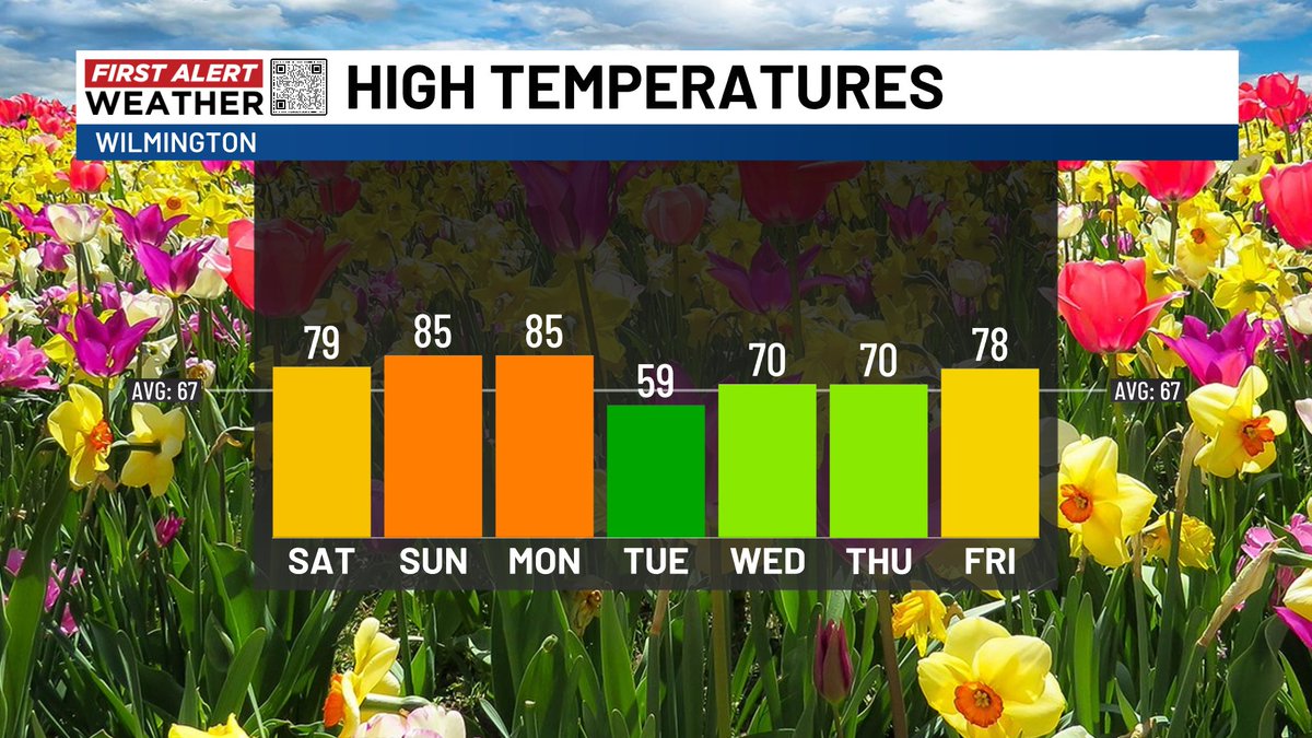
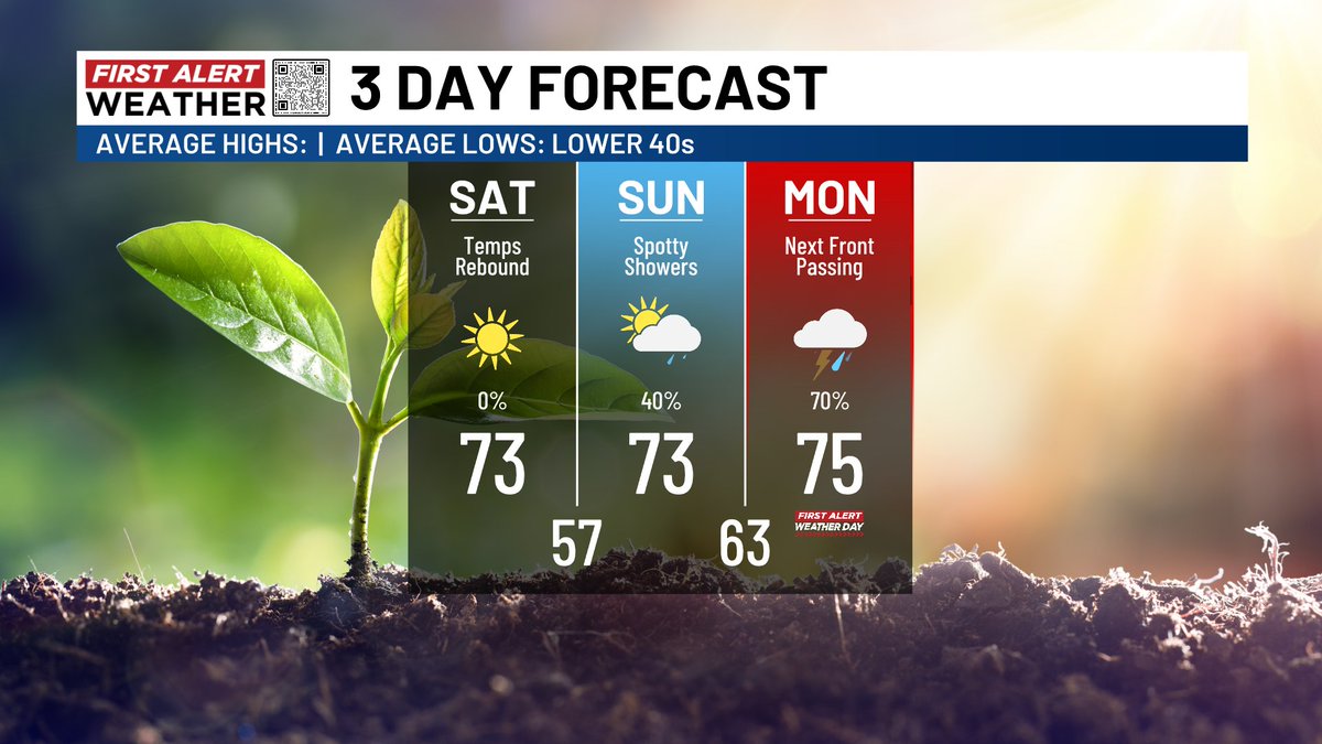
Saturday will be a gem! Perfect weather for the St. Patrick's Day Parade in Downtown Wilmington. Sunday will be nice too but there will be a shower risk. Have a way to receive warnings on Monday as severe weather is a real possibility. The threat could start in the morning and continue into the early evening. #WECTwx #ILMwx
Eric R. Davis WECT tweet media
English
0
0
1
122
Eric R. Davis WECT
Eric R. Davis WECT@ericdavisWECT·
A powerful Thursday cold front will drop lows into the 30s by Friday morning. Luckily 60s return for Friday afternoon and perfect lower 70s are on tap for Saturday in southeast NC. #WECTwx #ILMwx
English
0
0
2
191
Eric R. Davis WECT
Eric R. Davis WECT@ericdavisWECT·
Wilmington saw its hottest day of 2026 so far. A high of 86 ties a record set in 2016. The beaches of Brunswick County were much cooler with clouds and winds coming over still chilly water temperatures. #WECTwx #ILMwx
Eric R. Davis WECT tweet media
English
0
0
1
101
Eric R. Davis WECT
Eric R. Davis WECT@ericdavisWECT·
Rain chances will be few and far between through the weekend. Rain is at least possible early next week with better chances in about a week. #WECTwx #ILMwx
Eric R. Davis WECT tweet media
English
0
0
0
77