Zero Meter Chasers

5.3K posts

Zero Meter Chasers banner
Zero Meter Chasers

Zero Meter Chasers

@0meterChasers

Wx team with an acred Met. We provide live wx coverage bcast & with storm chasers. We focus on public safety. Business inquiries: [email protected]
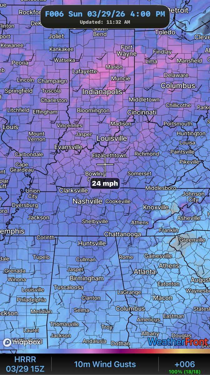
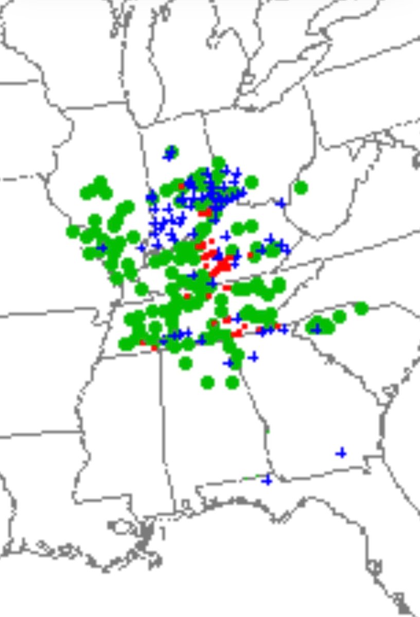
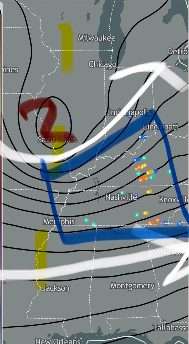
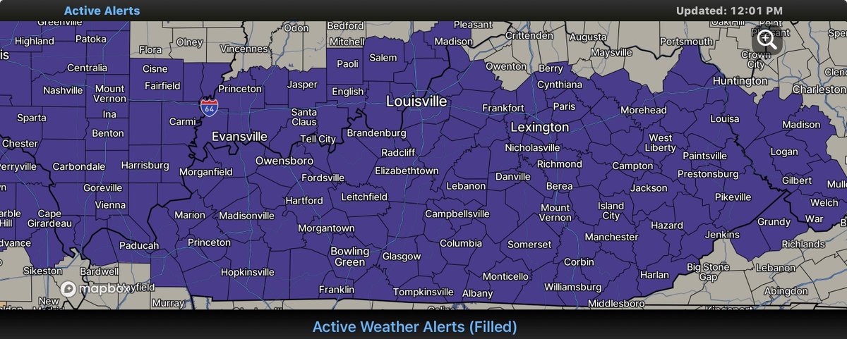
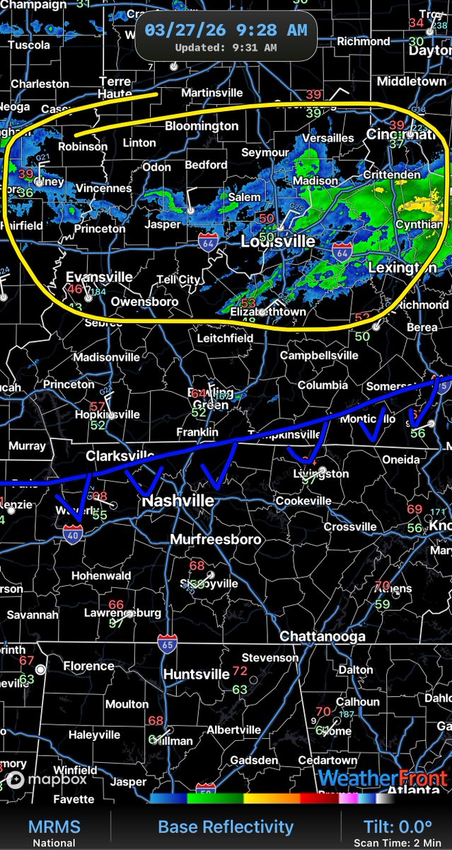
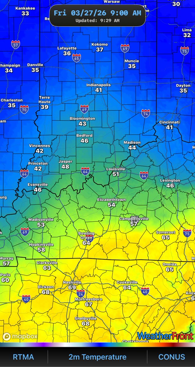
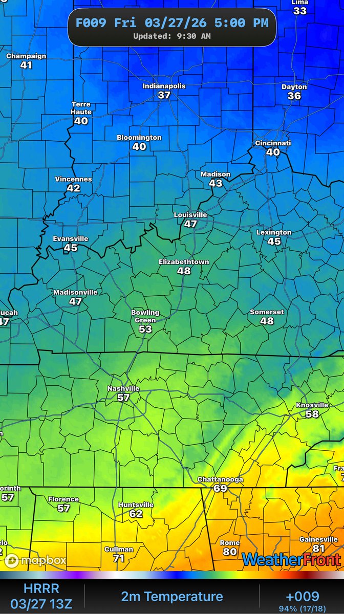
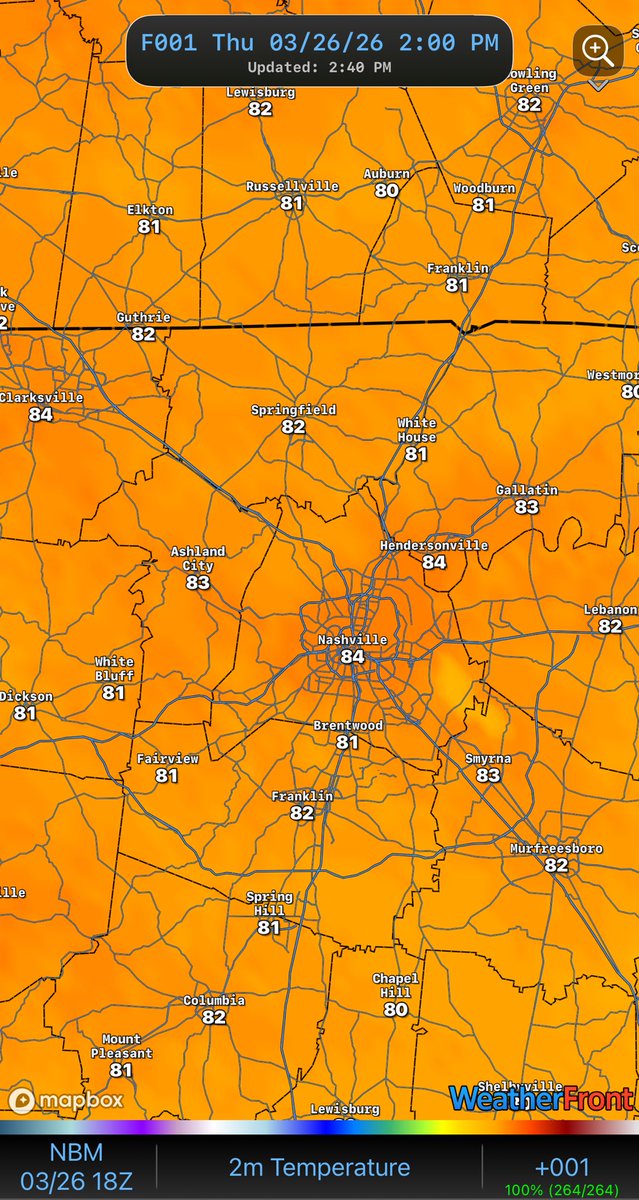
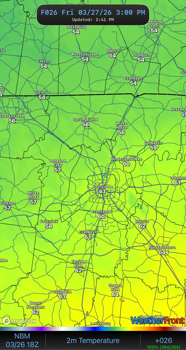
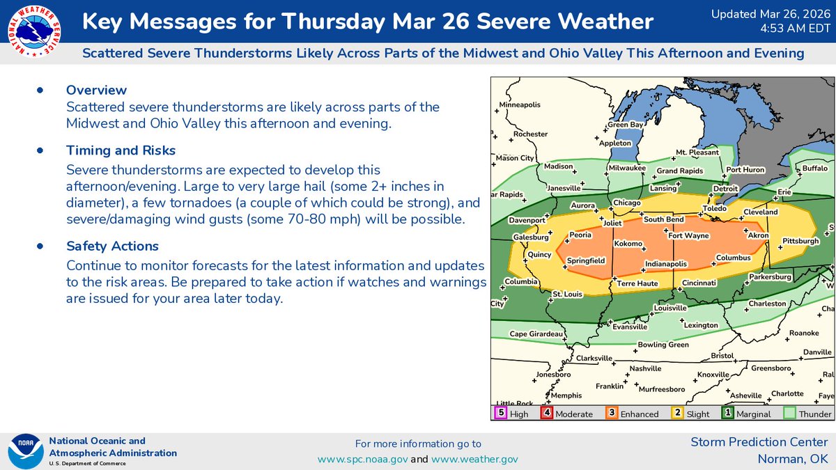
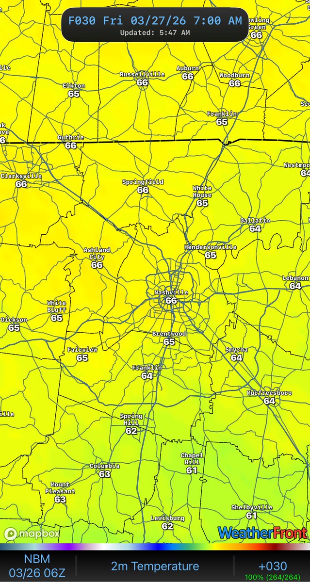
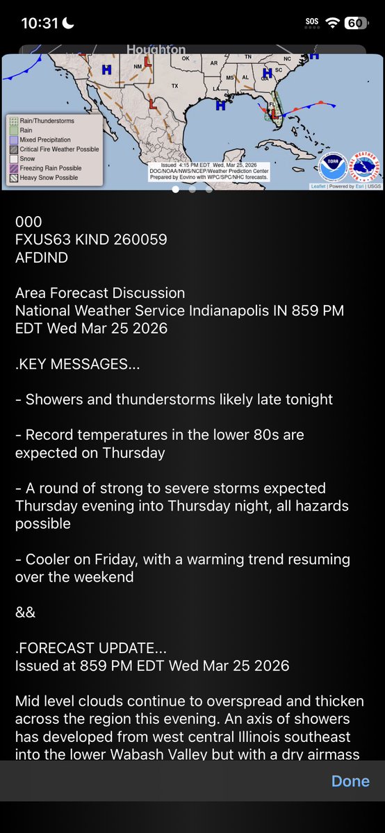
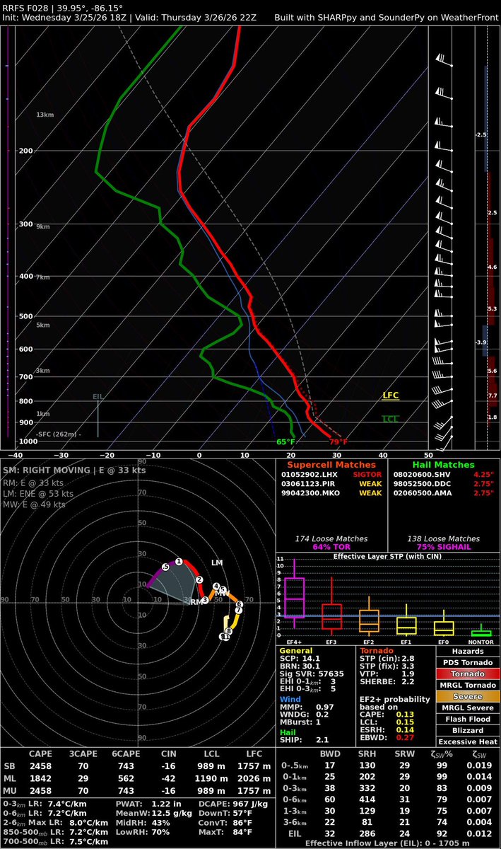
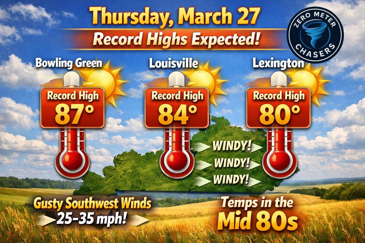
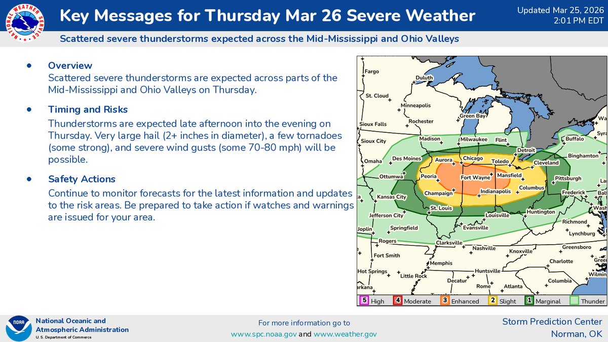
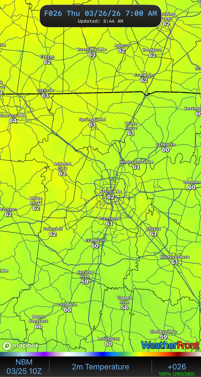
شامل ہوئے Nisan 2025
213 فالونگ1.1K فالوورز
Zero Meter Chasers ری ٹویٹ کیا
IEMBot PAH
IEMBot PAH@iembot_pah·
PAH issues Red Flag Warning for Alexander, Franklin, Hamilton, Jackson, Jefferson, Johnson, Perry, Saline, Union, Wayne, Williamson [IL] and Bollinger, Butler, Cape Girardeau, Perry, Scott, Stoddard, Wayne [MO] till Mar 29, 7:00 PM CDT mesonet.agron.iastate.edu/vtec/f/2026-O-…
IEMBot PAH tweet media
English
0
3
1
96
Zero Meter Chasers
Zero Meter Chasers@0meterChasers·
Sunday 3/29: Return Flow out of the Southwest with High Pressure off East Coast will bring gusty winds at times ~ 20-30mph. We’ll likely top out mid 60°s-Lower 70°s. -Mike
Zero Meter Chasers tweet media
English
0
0
1
83
Zero Meter Chasers
Zero Meter Chasers@0meterChasers·
OTD in 1997: A tight Mid Level wave ( 500mb Vort Maxima) Swept across the Lower OH Valley spawning several Tornadoes along & East of I-65 into Central/Southeast KY and into TN Valley. Showers lifted North of the River late in the day and cleared out a Dry slot for the airmass to recover. The Jet Streak of faster winds punched through South of Ohio River taping into warm moisture air producing Tornadic Supercells; one in particular was a F3 in Northern Hart Co (Bonnieville). This tornado crossed over I-65 and went into Larue Co. Several more smaller tornadoes occurred but another F3 Supercell impacted Northern Adair Co. Personal Note: I wished more information was provided as it was an impactful, yet sneaky setup. Sneaky, fast moving mid level speed maxes like this are hard to predict because you need just the right amount of instability, and thermodynamics to work given at the right time. This event started late in the day with a little bit of sun to destabalize fast. It was a fast event as the Low pivoted and turned negative tilt into the Evening for storms to rotate. -Mike
Zero Meter Chasers tweet mediaZero Meter Chasers tweet mediaZero Meter Chasers tweet mediaZero Meter Chasers tweet media
English
0
0
3
1.3K
Zero Meter Chasers
Zero Meter Chasers@0meterChasers·
Happy Saturday Mid TN gang! I hope y’all are not up early like me right now 🫩🥱. Your weekend forecast is coming hot off the grill. No I’m not grilling at 6am either 😂. SATURDAY: we’re starting off in the 30’s but will end up in the high 50’s to low 60’s and then over night cool back down into the low 40’s. What is worrisome in the afternoon is going to the fire danger. RH temps will drop into the 20’s and winds will be gusting out of the NE. Conditions will be just above red flag warning criteria. Please refrain from burning outside. Expect lots of sun today! SUNDAY: some will see 70° and others will remain in the high 60s. Lows won’t get down too much and stay in the high 50’s. The after will also feature very gusty winds out of the NE, low dew points and low humidity. RH will not be as low as Saturday but will be in the low 30’s. Clouds will come back and keep the sky partly sunny. ENJOY THE WEEKEND! -@BamaGirlwx
English
0
1
2
195
Zero Meter Chasers
Zero Meter Chasers@0meterChasers·
FREEZE WARNING (in purple shaded counties) for tonight. May want to bring in any sensitive plants as temperatures will drop below or near Freezing.
Zero Meter Chasers tweet mediaZero Meter Chasers tweet media
English
0
4
6
356
Zero Meter Chasers
Zero Meter Chasers@0meterChasers·
FRIDAY Mid-Morning Update: You can spot where the COLD FRONT is by two ways…. Direction of the Wind Barbs or the Temperature Gradient. We will DROP thru the day as Colder Air funnels in. Louisville likely can see the 40°s into late Afternoon. Light rain associated behind the front will slowly trickle South too. A *much* colder change as we head into tonight.
Zero Meter Chasers tweet mediaZero Meter Chasers tweet mediaZero Meter Chasers tweet media
English
0
3
4
370
Zero Meter Chasers
Zero Meter Chasers@0meterChasers·
Happy Friday Mid TN gang! 🎉 Today you will notice that we are a lot cooler than yesterday. The wind will brisk again until later tonight. There will be chances for so light to moderate rain fall but don’t expect much for accumulation as the total will be about 0.2”. It will not help tomorrow’s increased fire weather risk. Clouds sticks around today but tomorrow looks to be more sun filled. Have a great day! - @BamaGirlwx
Zero Meter Chasers tweet mediaZero Meter Chasers tweet mediaZero Meter Chasers tweet media
English
0
1
2
153
Zero Meter Chasers
Zero Meter Chasers@0meterChasers·
24 hour temp difference for Mid TN! Cold front will slide through and bring things back closer to where they should be for March. -@BamaGirlwx
Zero Meter Chasers tweet mediaZero Meter Chasers tweet media
English
0
0
2
114
Zero Meter Chasers
Zero Meter Chasers@0meterChasers·
Strong Southwest flow as I stated last night is increasing last couple hours. Gusts have been ~ 25-35mph. On bright side, no pun intended, LOTS of sunshine out there. Temps are anywhere in Upper 70°s-Lower 80°s at the Noon hour. Some can still see a Record High out there.
Zero Meter Chasers tweet mediaZero Meter Chasers tweet media
English
0
1
4
315
Zero Meter Chasers ری ٹویٹ کیا
NWS Storm Prediction Center
Here are our Key Messages for Thursday (3/26).
NWS Storm Prediction Center tweet media
English
2
58
174
46.3K
Zero Meter Chasers
Zero Meter Chasers@0meterChasers·
Happy Friday Eve Mid TN gang! We’re almost there!! Today is going to warm🥵, like 80’s kind of warm. Then mix in the SW wind, which will be a bit breezy and gusting up to around 25mph, so make sure you hang onto your hats, toupees and wigs! Even though the RH temps will be a bit higher today, with the wind being high again, it is not a day to burn outside. No rain expected today but tomorrow morning that’ll be different as with a chance for some light rain starts to move in around 10am. Make it a great day! -@BamaGirlwx
Zero Meter Chasers tweet mediaZero Meter Chasers tweet mediaZero Meter Chasers tweet mediaZero Meter Chasers tweet media
English
0
1
3
522
Zero Meter Chasers ری ٹویٹ کیا
WeatherFront
WeatherFront@WxFront·
Severe weather returns on Thursday. It’s the PERFECT time to: 🔴Overlay SPC outlooks on model guidance to visualize storm mode & timing 📜Instantly hop between Area Forecast Discussions 📍Interrogate model soundings in portrait mode as you make your chase target 📲Review NWS CWA boundaries and contact info
WeatherFront tweet mediaWeatherFront tweet mediaWeatherFront tweet media
English
1
11
35
2.3K
Zero Meter Chasers
Zero Meter Chasers@0meterChasers·
RECORD HIGHS in Jeopardy once again on Thursday: After a small disturbance rolls in through the overnight and mid-morning hours with rain chances, we will gradually warm up and clear out. Southerly flow will increase, as gusty winds at times will be likely in the Afternoon on Thursday. Many cities will flirt with Record Highs once again. What a month of warmth we have seen!
Zero Meter Chasers tweet media
English
0
1
2
832
Zero Meter Chasers ری ٹویٹ کیا
NWS Memphis
NWS Memphis@NWSMemphis·
Confidence is increasing in elevated fire danger this weekend. Low humidity and moderate winds mean fires can start and spread easily. Please check for burn bans before any outdoor activity. 🔥 #arwx #mowx #mswx #tnwx
NWS Memphis tweet media
English
0
8
15
2.5K
Zero Meter Chasers ری ٹویٹ کیا
NWS Storm Prediction Center
Here are our Key Messages for Thursday (3/26).
NWS Storm Prediction Center tweet mediaNWS Storm Prediction Center tweet media
English
1
64
166
42.9K
Zero Meter Chasers
Zero Meter Chasers@0meterChasers·
As I highlighted this morning, beautiful and tranquil conditions during the Lunch Hour across the Commonwealth; just a few passing clouds. -Mike Via: @kymesonet
Zero Meter Chasers tweet media
English
1
1
4
256
Zero Meter Chasers ری ٹویٹ کیا
Nadocast
Nadocast@nadocast·
12Z Day 2 Tornado Forecast for 2026-3-26 (New New 2022 Models)
Nadocast tweet media
English
0
31
166
18K
Zero Meter Chasers
Zero Meter Chasers@0meterChasers·
3/25 WEDNESDAY: The warmup begins. Southerly flow starts to surge over the Region as High Pressure builds to the Southeast. No rain chances, just plenty of Sun & above normal temperatures. Low to mid 70°s for Daytime Temps across North & South Central KY. -Mike
Zero Meter Chasers tweet media
English
0
1
4
311
Zero Meter Chasers
Zero Meter Chasers@0meterChasers·
Dew points are a little bit better today.
Zero Meter Chasers tweet media
English
0
0
1
95
Zero Meter Chasers
Zero Meter Chasers@0meterChasers·
Happy Hump Day Mid TN gang! We’re half way there 😮‍💨. Today is going to so awesome! EVERYONE WILL SEE MID 70’s TODAY! There will be a mix of sun and clouds and the breeze will be out of the S/SW 5-10 mph. Good news is that RH will be higher today, however with little to no rain lately, fire danger is on the rise. Tomorrow we could be talking about record highs possibly being broken as the ridge out west causing all of the heat, starts to move east today and tomorrow. Have a great day! -@BamaGirlwx
Zero Meter Chasers tweet mediaZero Meter Chasers tweet mediaZero Meter Chasers tweet mediaZero Meter Chasers tweet media
English
1
1
3
250