Journal of Remote Sensing

268 posts

Journal of Remote Sensing banner
Journal of Remote Sensing

Journal of Remote Sensing

@JournalofRS

Science (AAAS) partner journal for leading-edge research in remote sensing. We publish original research and review articles, editorials, and perspectives.

Beijing, China شامل ہوئے Ocak 2022
647 فالونگ478 فالوورز
Journal of Remote Sensing
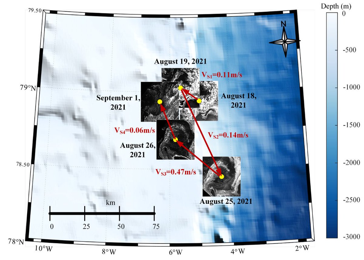
🛰️This study by Prof. Jinsong Chong uses sequential SAR imagery to retrieve the dynamical parameters of an ice-edge eddy and reveal its full lifecycle evolution. 🔑Keywords:Sequential SAR, Ice-edge eddy, Spatiotemporal evolution. 🔗Link: spj.science.org/doi/10.34133/r…
Journal of Remote Sensing tweet media
English
0
0
0
8
Journal of Remote Sensing
Journal of Remote Sensing@JournalofRS·
Microwave vegetation monitoring gets a climate upgrade Researchers from Beijing Normal University, Tongji University, INRAE, University of Montana, NASA Goddard Space Flight Center, Southwest University, and Chalmers University of Technology report a comprehensive assessment of multi-frequency Vegetation Optical Depth (VOD) products for climate–vegetation interaction analysis, published in the Journal of Remote Sensing (DOI: 10.34133/remotesensing.1028). Research focus The study evaluates seven satellite-derived VOD products (X-, C-, and L-band) across China (2012–2022), aiming to clarify how microwave frequency and retrieval differences influence vegetation–climate relationships. The analysis focuses on vegetation responses to air temperature, vapor pressure deficit (VPD), and soil moisture during the growing season. Key methodological contributions • A systematic intercomparison of seven VOD datasets from AMSR-E, AMSR2, SMAP, and SMOS. • Use of growing-season anomaly analysis combined with Pearson correlation to quantify climate sensitivity. • Inclusion of a one-month lag analysis to detect climate carry-over effects. • Cross-biome evaluation across seven plant functional types, from forests to croplands. Main findings • Microwave frequency plays a dominant role in shaping VOD–climate relationships, exceeding the impact of retrieval algorithms. • All VOD products show stronger sensitivity to water stress (soil moisture, VPD) than to temperature. • X- and C-band VOD capture rapid canopy dynamics and seasonal variability, while L-band VOD is more sensitive to woody biomass and long-term structural signals. • Significant one-month carry-over effects were identified, particularly in arid and semiarid ecosystems. • Product behavior varies substantially: for example, LPDR-X shows the strongest positive soil moisture correlation (r = 0.16), whereas MCCA-SMAP shows a strong negative response (r = −0.40). Implications The study demonstrates that VOD is not a uniform indicator of vegetation dynamics, and that frequency selection is critical for specific ecological applications. High-frequency signals are better suited for short-term vegetation stress detection, whereas low-frequency signals provide insights into longer-term biomass and structural changes. These findings provide a clearer framework for selecting appropriate microwave products in applications such as drought monitoring, ecosystem resilience assessment, and climate-impact studies. Paper:spj.science.org/doi/10.34133/r… #RemoteSensing #EarthObservation #MicrowaveRemoteSensing #Vegetation #ClimateChange #DroughtMonitoring #GeospatialScience
Journal of Remote Sensing tweet media
English
0
0
1
64
Journal of Remote Sensing
Journal of Remote Sensing@JournalofRS·
Which Vegetation Indices Perform Better? A Comparative Analysis from the Perspective of Resistance to Soil Background effect A new study by Prof. Cong Wang systematically evaluated the sensitivity of various soil-resistant vegetation indices under different soil conditions through 3D radiative transfer model simulations and ground-based experiments, clarified the applicable scenarios of different vegetation indices against complex soil backgrounds, and thus provided a scientific basis for the selection of vegetation indices in remote sensing applications. Link:spj.science.org/doi/10.34133/r…
Journal of Remote Sensing tweet mediaJournal of Remote Sensing tweet media
English
0
1
2
68
Journal of Remote Sensing
Journal of Remote Sensing@JournalofRS·
Precision soil salinity mapping powered by UAV intelligence Researchers from the Institute of Agricultural Resources and Regional Planning, Chinese Academy of Agricultural Sciences report a new framework for high-resolution soil salinity estimation using UAV multispectral data and ensemble learning, recently published in the Journal of Remote Sensing (DOI: 10.34133/remotesensing.0805). Research focus The study introduces a feature-optimized and performance-weighted ensemble learning framework designed to improve soil salinity prediction at the field scale. By integrating UAV multispectral imagery (green, red, red-edge, and near-infrared bands) with key soil variables, including soil organic matter and pH, the framework captures complex relationships between spectral signals and soil properties. Key methodological advances • A hybrid embedded feature-selection strategy used to identify the most sensitive predictors of soil salinity. • A performance-weighted ensemble learning approach that dynamically integrates multiple machine-learning models according to predictive reliability. • An optimized modeling framework that improves generalization performance while reducing redundancy among base learners. Main results • The proposed framework achieved a coefficient of determination exceeding 0.75, with reduced prediction error and uncertainty compared with conventional machine-learning and stacking models. • UAV-derived salinity indices, together with soil organic matter and pH, were identified as the most influential predictors. • The method enabled sub-meter resolution soil salinity mapping, revealing fine-scale spatial gradients and localized salinity hotspots in saline agricultural fields. Implications According to the researchers, the results demonstrate how integrating UAV remote sensing with intelligent ensemble modeling can enhance soil salinity monitoring and spatial prediction accuracy. The authors note that the framework provides a scalable approach for high-resolution soil monitoring and may be extended to broader regions and additional soil properties, supporting future applications in precision agriculture and land management. Paper DOI: 10.34133/remotesensing.0805 #RemoteSensing #UAV #SoilSalinity #PrecisionAgriculture #MachineLearning #DigitalAgriculture
Journal of Remote Sensing tweet media
English
0
0
1
75
Journal of Remote Sensing
Journal of Remote Sensing@JournalofRS·
Why GNSS-R Soil Moisture Retrieval Has Long Relied on Reference Products—and How Physics Is Changing That Satellite soil moisture retrieval has long depended on reference datasets for calibration. While effective, this approach reduces transparency and limits the transferability of retrieval algorithms across regions, time periods, and satellite missions. A new study published in the Journal of Remote Sensing introduces PHYSER, a physics-based framework that retrieves soil moisture without relying on external reference products. The method reconstructs soil surface reflectivity directly from GNSS-R observations through physical corrections for satellite geometry, vegetation attenuation, and surface roughness, then converts reflectivity into soil moisture using dielectric models. Validated using observations from the BuFeng-1 A/B GNSS-R satellites, the results show strong agreement with independent satellite products, reanalysis datasets, and global in-situ measurements. By grounding retrieval in physics rather than statistical calibration, PHYSER offers a transparent and scalable pathway for future GNSS-R soil moisture monitoring, supporting improved hydrological forecasting, climate research, and agricultural applications. Read the full paper: spj.science.org/doi/10.34133/r… #RemoteSensing #GNSSR #SoilMoisture #EarthObservation #SatelliteData #Hydrology #ClimateScience #Geoscience #OpenScience #JournalOfRemoteSensing
Journal of Remote Sensing tweet media
English
0
1
1
95
Journal of Remote Sensing
Journal of Remote Sensing@JournalofRS·
💡Profs. Jing Wei from Peking University, Guest Editor of the Journal of Remote Sensing, Zhanqing Li from the University of Maryland, and Lin Sun from Shandong University of Science and Technology have collaboratively published a new paper titled “AeroTrans: Hourly AOD Retrieval over Land from MSG-1/SEVIRI Imagery Integrating Transformer and Transfer Learning.” 🛰️This study introduces a novel Transformer-based model with transfer learning for aerosol optical depth (AOD) retrieval from MSG observations. The proposed framework significantly improves retrieval performance, particularly over under-monitored regions. The hourly AOD retrievals achieve high accuracy, with a cross-validated R2 reaching 0.88. In addition, the results effectively capture the diurnal variability of AOD and aerosol transport during pollution events. 🖇️The full article is available at: doi.org/10.1016/j.rse.…
Journal of Remote Sensing tweet media
English
0
0
2
68
Journal of Remote Sensing
Journal of Remote Sensing@JournalofRS·
Atmospheric temperature profiles are crucial for weather forecasting and climate monitoring. Existing retrieval methods often face a trade-off between physical consistency and computational efficiency. A new study by by Prof. Renlong Hang from Nanjing University of Information Science and Technology presents a physical knowledge constrained neural network for temperature profile retrieval. It integrates physical knowledge into the feature learning and model optimization processes to obtain more accurate and reliable retrieval results, providing an idea for building a trustworthy AI meteorological model. Check out the full study here: doi.org/10.34133/remot… Keywords: Convolutional neural network, Physical knowledge, Temperature proflie retrieval, Attention module
Journal of Remote Sensing tweet media
English
0
0
0
53
Journal of Remote Sensing
Journal of Remote Sensing@JournalofRS·
Exciting research published in Journal of Remote Sensing! The article DeepForest: Sensing into Self-occluding Volumes of Vegetation with Aerial Imaging, developed by researchers from the Institute of Computer Graphics, Johannes Kepler University Linz (Austria) Oliver Bimber (@obimber), introduces an innovative approach to forest remote sensing. By combining drone-based synthetic aperture imaging with 3D convolutional neural networks, the method enables conventional high-resolution aerial imagery to “see” deeper into dense forest canopies and capture volumetric information within self-occluding vegetation. This breakthrough opens new possibilities for understanding forest structure, assessing plant health, and monitoring ecosystem dynamics. Since publication, the study has attracted strong international attention, achieving an Altmetric score of 155 and being reported or reposted by 24 international media outlets. spj.science.org/doi/10.34133/r… #RemoteSensing #Forests #AI #DroneTechnology #EarthObservation
Journal of Remote Sensing tweet media
English
0
0
0
79
Journal of Remote Sensing
Journal of Remote Sensing@JournalofRS·
How does grazing pressure reshape the "functional structure" of our grasslands? A new study by Zhiyao Tang’s team (Peking University) employed UAV-based hyperspectral analysis to map the complex responses of grassland functions to grazing intensity. Highlight: They’ve unlocked a high-precision method to track ecosystem health from the sky, revealing the critical tipping points of grazing-induced land changes. Check out the full study here: spj.science.org/doi/10.34133/r… Keywords: #UAV #RemoteSensing #Grasslands #Ecology #Hyperspectral #AgriScience #Sustainability
Journal of Remote Sensing tweet media
English
0
2
5
127
Journal of Remote Sensing
Journal of Remote Sensing@JournalofRS·
📡From Crop Diagnosis to Actionable Prescription Maps: UAVs Make Precision Nitrogen Management Real Nitrogen management is one of the most critical — and challenging — issues in tobacco production. Too much nitrogen compromises quality and the environment; too little directly limits yield. Yet in practice, fertilization decisions are still often experience-based and spatially uniform. In our recent study, we propose a UAV-based nitrogen decision-making framework that truly bridges the gap between remote sensing diagnosis and field-level execution. 🔍What’s new? Instead of relying on a single vegetation index, we integrate multiple structural and physiological traits — LAI, leaf biomass, chlorophyll content, and leaf nitrogen content — into a unified indicator, the Recommended Nitrogen Application Index (RNAI). Machine learning (with XGBoost outperforming RF) is used to robustly invert these traits from UAV multispectral imagery, enabling stable and accurate nitrogen demand assessment. 🌐Why UAVs instead of satellites? UAVs are not just “higher resolution satellites” — they are better aligned with precision agriculture in practice: · Centimeter-level spatial resolution avoids mixed-pixel effects and captures within-field heterogeneity. · Flexible timing allows flights exactly at key growth stages and fertilization windows, even under cloudy conditions. · High timeliness enables same-day processing from flight to prescription map. · Sensor configurability (multispectral, hyperspectral, thermal) allows band selection tailored to nitrogen and water stress. · Actionable outputs: high-resolution prescription maps can be directly imported into variable-rate machinery, avoiding spatial mismatches common with coarse satellite grids. · Cost-effectiveness: for fields under ~1,000 mu, UAV operations are often more economical than repeated commercial satellite data purchases. 🗺️ Most importantly: it works in the field. Applying the UAV-derived prescription maps: · Reduced pure nitrogen use by 3.71 kg/ha · Increased yield by 54.56 kg/ha · Improved economic returns by 2.58% · Enhanced within-field uniformity 🌱Takeaway This work demonstrates that UAV-based remote sensing can move beyond “monitoring” to become a decision engine — delivering precise, executable, and scalable nitrogen management solutions. It’s a practical pathway for closing the “last mile” of precision fertilization. 📰Paper: A Nitrogen Application Decision-Making Scheme for Tobacco Growth Based on UAV Multispectral Imagery spj.science.org/index/remotese… 📍Journal of Remote Sensing, 2026 #PrecisionAgriculture #UAV #RemoteSensing #NitrogenManagement #DigitalFarming #SmartAgriculture #MachineLearning #VariableRateApplication
Journal of Remote Sensing tweet media
English
0
0
0
35
Journal of Remote Sensing
Journal of Remote Sensing@JournalofRS·
Fast, accurate, and uncertainty-aware AI for satellite CO₂. A recent Journal of Remote Sensing study presents a lightweight probabilistic framework that upgrades any neural network to deliver calibrated uncertainty—without changing its architecture. (By Prof. Tao Ren) Validated on OCO-2 (2017–2024): 99.21% within ±3σ, at millisecond speed. A scalable path toward real-time global carbon monitoring. Learn more: doi.org/10.34133/remot… Keywords: #AI, #CarbonMonitoring, #AI4Science, #OCO2.
Journal of Remote Sensing tweet media
English
0
0
0
55
Journal of Remote Sensing
Journal of Remote Sensing@JournalofRS·
Profs. Jing Wei from Peking University, Guest Editor of Journal of Remote Sensing, and Zhanqing Li from the University of Maryland have collaboratively published a new paper in Remote Sensing of Environment titled “Enhancing cloud detection across multiple satellite sensors using a combined Swin Transformer and UPerNet deep learning model.” This study introduces an integrated Swin Transformer–UPerNet cloud mask model (STUPmask), which achieves overall accuracies of 97.5% on Landsat 8 and 96.3% on Sentinel-2. Notably, STUPmask demonstrates strong adaptability across both low-Earth-orbit and geostationary satellites with varying spatial resolutions. The full article is available at: doi.org/10.1016/j.rse.…
Journal of Remote Sensing tweet media
English
0
1
1
61
Journal of Remote Sensing
Journal of Remote Sensing@JournalofRS·
Human activities are driving global dryland greening 🌍🌱 For decades, drylands have been widely associated with desertification and ecological decline. But a new global assessment suggests a more complex—and more human-driven—story is unfolding. A study published in the Journal of Remote Sensing (spj.science.org/doi/10.34133/r…) presents a 24-year satellite-based analysis of vegetation productivity across global drylands, revealing widespread greening rather than large-scale degradation. Using long-term satellite-derived gross primary productivity (GPP) data, researchers quantified not only where drylands are greening, but also what is driving this change. What the satellites show 📡 From 2001 to 2024, 29.2% of global drylands experienced significant greening, while only 4.9% showed browning. In total, drylands accumulated a net gain of 1,899 teragrams of carbon, with Asia contributing nearly half of the increase. Crucially, the study finds that human-dominated land cover—especially croplands—plays a disproportionate role. Although croplands account for only about 12% of dryland area, they contributed 773 Tg of carbon gain, making them one of the strongest drivers of observed greening. Who is driving the greening? Through statistical attribution, the researchers show that human activities outweigh both climate and CO₂ fertilization effects. Cropland expansion, nitrogen fertilizer use, and irrigation together exerted more than twice the influence of rising atmospheric CO₂, while climate variables played only a minor role. By contrast, current Dynamic Global Vegetation Models substantially underestimated greening across nearly 87% of observed regions, largely because they fail to represent realistic land-use intensity and agricultural management. Why it matters 🌍 These findings challenge the long-held assumption that dryland greening is primarily a passive response to climate and CO₂. Instead, they highlight active human land management as a dominant force reshaping dryland ecosystems. At the same time, the authors caution that greening is not automatically beneficial. Unsustainable irrigation, groundwater depletion, and intensive farming could undermine long-term ecosystem resilience. Accurately representing human land-use dynamics in Earth system models will be critical for predicting the future of drylands under climate change. #RemoteSensing #Drylands #GlobalChange #LandUse #CarbonCycle #EarthObservation #ClimateScience #JournalOfRemoteSensing #HumanImpacts #Sustainability
English
0
2
5
155
Journal of Remote Sensing ری ٹویٹ کیا
Journal of Remote Sensing
Journal of Remote Sensing@JournalofRS·
[Job Opportunity] Postdoctoral Position in Remote Sensing & Global Environmental Change (GERS Lab, UConn) The Journal of Remote Sensing (JRS) is pleased to share a new postdoctoral opportunity from the Global Environmental Remote Sensing (GERS) Laboratory at the Department of Natural Resources and the Environment, University of Connecticut (UConn), led by Prof. Zhe Zhu. 🔗 Lab website: gerslab.cahnr.uconn.edu Position: Postdoctoral Researcher Field: Remote Sensing & Global Environmental Change Location: Storrs, CT, USA Start Date: Flexible; earliest start date is February 1 (review of applications begins December 20) Salary Range: $62,232–$70,344 This position will lead the remote sensing component of an NSF-funded project: “Collaborative Research: BoCP-Implementation: Estimating the extinction risk of biodiversity with a time-based dynamic system.” The project (NSF Award, total funding approx. $1.95M) is a high-impact, interdisciplinary collaboration between the GERS Laboratory (UConn) and Prof. S. Blair Hedges (Temple University). It aims to transform how biodiversity extinction risk is estimated by integrating dense satellite time series with biological data to model habitat dynamics over time. As a key member of this team, the postdoctoral researcher will develop novel approaches to map primary forests and quantify their changes across large spatial scales. The resulting products will directly support time-based dynamic systems that estimate species extinction probabilities, linking cutting-edge remote sensing with urgent conservation biology needs. Key Responsibilities · Algorithm Development: Develop and refine algorithms for mapping primary forests and detecting land-cover changes using dense time series of satellite data (e.g., Landsat, Sentinel-2). · Interdisciplinary Collaboration: Work closely with the biodiversity research team at Temple University to align spatiotemporal habitat data with species distribution and extinction risk models. · Scientific Communication: Lead or contribute to high-impact peer-reviewed publications and present research findings at major international conferences (e.g., AGU, AAG). Qualifications Required · Ph.D. in Remote Sensing, Geography, Earth System Science, Computer Science, or a related field (by the start date). · Strong expertise in time series analysis of optical satellite data (Landsat/Sentinel). · Demonstrated experience in forest monitoring (experience with primary forests or subtle degradation is a strong plus). · Proficiency in programming (Python, R, or MATLAB) and geospatial data processing. · Experience with cloud computing platforms, particularly Google Earth Engine (GEE). · A strong publication record in leading remote sensing or environmental science journals. How to Apply Please submit the following materials as a single PDF file to Dr. Zhe Zhu at zhe@uconn.edu: 1. Cover Letter (1–2 pages) describing your research interests, qualifications, and why you are interested in this specific BoCP project. 2. Curriculum Vitae (CV), including a full list of publications.
English
0
2
3
180
Journal of Remote Sensing ری ٹویٹ کیا
Journal of Remote Sensing
Journal of Remote Sensing@JournalofRS·
🌍 Call for Submissions | Special Issue on Foundation Models & Multimodal EO Fusion ✨ Publish for FREE | APCs waived through June 2030 ✨ The Journal of Remote Sensing (JRS) launches a new Special Issue: “Foundation Models–based Multimodal Earth Observation Data Fusion and Applications” We invite innovative research that advances multimodal/multisensor fusion, foundation models, and large-scale Earth system applications. 🔎 Topics of Interest · Foundation model–based multimodal & multisensor data fusion · Representation learning and large EO models · Change detection, environmental monitoring & land-cover mapping using foundation models · Time-series analysis & global/regional Earth system applications · AI/ML methods for large-scale EO data · Benchmarking, validation & uncertainty analysis of geospatial foundation models 🤵‍♂️ Guest Editors Le Yu (Tsinghua University, China) Nan Xu (Shenzhen University, China) David Coomes (University of Cambridge, USA) Nicholas Clinton (NASA, USA) Nikola Trendov (FAO, Italy) Hankui Zhang (South Dakota State University, USA) 🗓️ Submission Deadline: December 31, 2026 🚀 Submit Here (FREE to Publish): 🔗spj.science.org/page/remotesen… ✔ No submission fees ✔ APCs fully waived through June 2030 📌 Recommended Hashtags #RemoteSensing #EarthObservation #AI #MachineLearning #DeepLearning #FoundationModels #MultimodalData #GeospatialAI #EODataFusion #ClimateScience #EarthSystemScience #GlobalMonitoring #OpenScience #AcademicPublishing #CallForPapers
English
0
2
2
125
Journal of Remote Sensing
Journal of Remote Sensing@JournalofRS·
⚡️AIR Organizes Regional Crop Monitoring Training in Peru⚡️ From 2 to 5 December 2025, the Aerospace Information Research Institute (AIR), Chinese Academy of Sciences, together with the United Nations Conference on Trade and Development (UNCTAD) and Peru’s National Institute of Agricultural Innovation (INIA), co-hosted the “Regional training workshop for advancing satellite crop monitoring to enhance agricultural resilience using the CropWatch cloud system in Latin America and the Caribbean” in Lima, Peru. More than 40 specialists in agriculture and remote-sensing technology from eight countries—including China, Peru, Ecuador, Guatemala, Honduras, Jamaica and the Dominican Republic—took part. With the theme “Enhancing Agricultural Resilience”, the course was built around AIR’s CropWatch cloud platform. Participants received hands-on instruction in key techniques such as crop-area estimation, yield prediction, agro-condition analysis and field sampling. The training was led by Prof. Bingfang Wu, Associate Prof. Miao Zhang and Assistant Prof. You Tian of AIR. On-site activities included production of critical agro-condition parameters, a demonstration of the CropWatch-GPT large-language-model system and generation of customized analytical reports for individual countries. At the closing ceremony Prof. Wu presented completion certificates and welcomed all participants into the CropWatch Latin-American technical cooperation network. Agricultural officials from several countries said they plan to integrate CropWatch indicators into their national food-security emergency systems and will shortly propose follow-up arrangements for data sharing and joint research. The event marks the first large-scale implementation of the CropWatch system in Latin America, further expanding AIR’s agro-monitoring partnership network and global influence.
Journal of Remote Sensing tweet mediaJournal of Remote Sensing tweet mediaJournal of Remote Sensing tweet media
English
0
1
2
110