ZoneWatch

173 posts

ZoneWatch banner
ZoneWatch

ZoneWatch

@ZoneWatchWX

Severe Weather Intelligence App. High-resolution radar, AI predictions & forecasts, and accurate warnings. Available on iOS and Android.

Stay safe → شامل ہوئے Aralık 2024
131 فالونگ882 فالوورز
پن کیا گیا ٹویٹ
ZoneWatch
ZoneWatch@ZoneWatchWX·
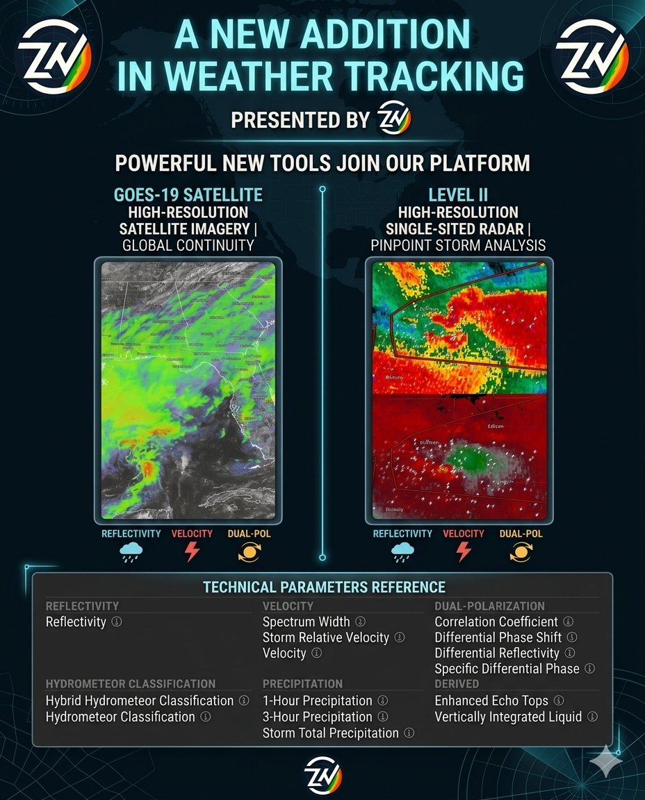
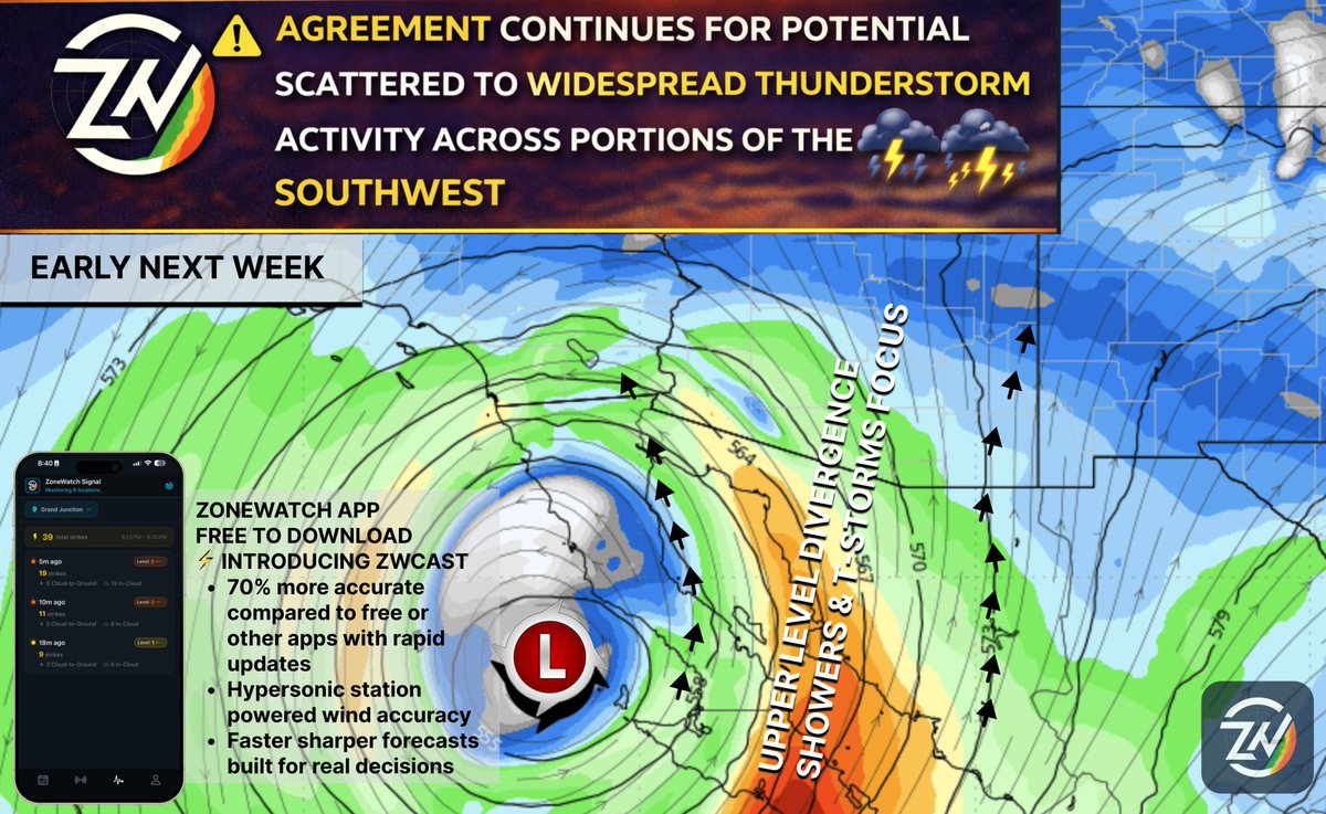
Introducing ZoneWatch 3.0 Near-3D NEXRAD radar, 2D/3D fusion modeling, and live lightning strikes that update in SECONDS. ⚡️ Stop reacting. Start predicting. Lock in the yearly deal ($5.56/mo) now: 👉 zonewatchpro.com/download?promo…
English
0
1
2
73
ZoneWatch
ZoneWatch@ZoneWatchWX·
What a crazy view of the frequency of lightning inside this cell. You can also see the structure of this massive thunderstorm.
English
0
0
0
55
ZoneWatch ری ٹویٹ کیا
Sina Moghaddami
Sina Moghaddami@sin_mogh·
Coming soon to ZoneWatch web, followed by the app in the coming weeks: NEXRAD Level II Super-Res Site Selection Radar. Stay tuned for updates.
Sina Moghaddami tweet media
English
0
1
3
93
ZoneWatch ری ٹویٹ کیا
Sina Moghaddami
Sina Moghaddami@sin_mogh·
⚠️ STRONG BAND OF STORMS EXPECTED TO SLAM THE BAY AREA TONIGHT Summary: A powerful line of heavy rain and intense storms will push onshore later today, taking direct aim at the Bay Area down through the Central Coast. Impact: Expect torrential downpours, localized roadway flooding, and very dangerous driving conditions for the evening commute. Convective storms could also bring frequent lightning as well. ⏰ Timing: Storms to slam the coast and move inland right around 6:00 PM PT tonight. Track the exact timing for your city on the ZoneWatch app! Image from future radar HRRR.
Sina Moghaddami tweet media
English
0
1
4
123
ZoneWatch ری ٹویٹ کیا
Sina Moghaddami
Sina Moghaddami@sin_mogh·
⚠️ SoCal Sunday Morning Rain Update ⚠️ The system that hit NorCal is moving south, but as ZoneWatch predicted, it’s underperforming down here. Very low thunderstorm risk likely just showers, but expect slick roads! ⏰ Sunday Estimated Timing: 📍 Ventura: 3:00 AM PT 📍 LA / Orange County: 6:00 AM PT 📍 San Diego: Noon PT Scattered showers will linger on and off through Monday morning. 📱 App News: A massive update featuring ZWCast drops this Thursday! For exact timing or other regions, check the ZoneWatch app.
Sina Moghaddami tweet media
English
0
1
2
53
ZoneWatch ری ٹویٹ کیا
Sina Moghaddami
Sina Moghaddami@sin_mogh·
🚨 Rain Coming to LA DT Heads up! Our proprietary ZoneWatch tracking shows precipitation picking up over the weekend. Here is the breakdown for the next 48 hours.
Sina Moghaddami tweet media
English
0
1
3
46
ZoneWatch ری ٹویٹ کیا
Sina Moghaddami
Sina Moghaddami@sin_mogh·
⚠️  Severe T-Storms, Rain Showers, Windy Conditions and Cooler Weather to Impact the West Coast this Weekend Starting Today A potent upper-level trough and cut-off low are clashing with subtropical moisture, bringing a highly dynamic weekend of weather! ⛈️ NorCal: Scattered Severe T-Storms today (hit or miss) 🌨️ Sierras: Heavy snow dropping to 4,500ft tonight ☔ WA/OR/ID: Coastal rain & mountain snow 💨 NV/UT: 40-50mph gusts & blowing dust 🌧️ SoCal: Scattered weekend showers (no severe risk) Sunday watch for t-storm risk especially morning hours🏜️ AZ/NM: Dry/windy today, light showers by Sunday also monitoring t-storm risk 📱 Track exact timing for your area on the ZoneWatch app!
Sina Moghaddami tweet media
English
0
1
3
58
ZoneWatch
ZoneWatch@ZoneWatchWX·
🚨 COMING SOON: Level II High Resolution Radar & More We’re unlocking the most powerful tools in meteorology used by pros. Stay ahead of the storm with: 📡 Level II High-Res Radar: Go microscopic. Track rotation, hail, and tornado debris with single-site precision. 🛰️ GOES-19 Satellite: Lightning-fast imagery & the new CCOR-1 solar sensor. Whether you're a pro or just staying safe, this is a total game-changer.
ZoneWatch tweet media
English
0
1
2
104
ZoneWatch ری ٹویٹ کیا
Sina Moghaddami
Sina Moghaddami@sin_mogh·
I am tracking a potent cutoff low set to impact the West Coast late next week. Timing is subject to change with these systems, but a blocking ridge to the north will likely keep the heaviest rain over California and the Desert Southwest. The Impacts: Heavy Rain: Primary threat for CA with urban flooding risks. Flash Flooding: High risk for desert washes in NV and AZ. High Peaks Snow: Restricted to elevations above 8000 ft. Thunderstorms: Isolated storms with gusty winds possible. Peak Timing: Wed thru Thu: Northern and Central CA. Friday: Peak impact for Southern CA and Vegas. Sat thru Sun: Rain shifts into Phoenix and Utah. While general apps give a rough idea, ZoneWatch provides granular hour by hour breakdowns to help you pinpoint the best outdoor windows. Download for FREE and get 15% off Premium:zonewatchpro.com/download?ref=S…
Sina Moghaddami tweet media
English
0
1
4
79
ZoneWatch ری ٹویٹ کیا
Sina Moghaddami
Sina Moghaddami@sin_mogh·
Some mid and upper level moisture is moving into Southern California due to the jet stream dip mentioned last week. Expect scattered showers that are mainly light, though northern areas like Ventura, LA, and Santa Barbara could see a few heavier bursts. For more info, check the ZoneWatch app. Overall, nice cooler weather with a few showers here and there. Feels nice and relaxing here in SD… ZoneWatch 🛡️ Get ZoneWatch to stay ahead of spontaneous changes… Download for FREE… want to get everything we offer? LMITED 15% off Premium to track the heat in your specific zone and much more!: zonewatchpro.com/download?ref=S…
Sina Moghaddami tweet media
English
0
1
3
81
ZoneWatch ری ٹویٹ کیا
Sina Moghaddami
Sina Moghaddami@sin_mogh·
EARLY MONSOON VIBES? ⛈️ T-Storms Return Tuesday! The heat ridge is shifting, pulling a moisture surge across AZ, Southern NV, and NM. Expect isolated "hit-or-miss" storms with a high risk for dry weather hazards. ⚠️ EXPECTED IMPACTS: ⚡ Dry Lightning: High strike risk + minimal rain = wildfire concern. 💨 Dry Microbursts: Sudden winds (45mph+) & localized dust storms. Something to watch. 🌡️ Lingering Heat: Remaining unseasonably warm; stay hydrated! ☁️ Spotty T-Storms: Highly localized; flooding is NOT a major threat. 🕒 TIMING: Activity peaks Tuesday (2 PM – 7 PM) starting over mountains before drifting into valleys. @ZoneWatchWX
Sina Moghaddami tweet media
English
0
1
2
58
ZoneWatch ری ٹویٹ کیا
Sina Moghaddami
Sina Moghaddami@sin_mogh·
ISOLATED T-STORMS ANTICIPATED ACROSS PORTION OF AZ ON SUNDAY A moisture surge combined with a disturbance brings a risk of for t-storms across portions of AZ on Sunday. 📍 Key Areas: Phoenix, Tucson, Yuma, Casa Grande, Globe, Safford, Sierra Vista, Nogales, Blythe, and El Centro. ⚠️ Impacts: ⚡ Dry Lightning: Cloud-to-ground strikes with minimal rain. 💨 Powerful Winds: Sudden, localized damaging gusts. ☁️ Hit-or-Miss: Coverage is spotty, but the risk is real across the zone.
Sina Moghaddami tweet media
English
0
1
2
168
ZoneWatch ری ٹویٹ کیا
Sina Moghaddami
Sina Moghaddami@sin_mogh·
PRELIMINARY FORECAST: Isolated T-Storms return to AZ this Sunday (3/29)! ⛈️ A moisture surge brings a risk of dry lightning (fire hazard) and localized damaging winds. Coverage will be highly "hit-or-miss," but the chance is there...
Sina Moghaddami tweet media
English
0
1
2
77
ZoneWatch ری ٹویٹ کیا
Sina Moghaddami
Sina Moghaddami@sin_mogh·
❓ WEST COAST PATTERN CONFIRMATIONS VS WHATS UNCLEAR STILL The West Coast is shifting into an active weather pattern. While high-confidence features are aligning, specific mesoscale details remain naturally uncertain this far out. 🛰️ ✅ CONFIRMED: Jet Stream: Aimed directly at California. Cooler Temps: Below-average for late March. Widespread Rain: Multiple systems are projected to impact the coast. ⚠️ UNCERTAIN: Totals: Exact rain accumulations and "heaviness." Focus: Specific impact zones where the heaviest rain stalls. Intensity: Peak wind speeds and system strength. The ZWCAST Edge:If ZoneWatch currently shows minimal rain totals, it is by design. ZWCAST technology prioritizes high-confidence events over speculation to prevent over- or under-planning. As the window narrows, the forecast will reflect the shifting data.
Sina Moghaddami tweet media
English
0
1
3
76
ZoneWatch ری ٹویٹ کیا
Sina Moghaddami
Sina Moghaddami@sin_mogh·
EARLY HISTORIC HEATWAVE ONGOING PEAKING ON THURSDAY FOR THE WEST COAST | END OF MONTH PATTERN CHANGE EXPECTED Hope you’re loving "summer"—I guess we complained a little too much about the cold and wet conditions! Careful what you wish for... ☀️🥵 A massive ridge of high pressure is locked over the region, creating a "heat dome" that traps sinking air and bakes the surface. While the Southwest sizzles, an Atmospheric River is still pushing disturbances into the Pacific Northwest. CA & AZ: Extreme heat for the Central Valley and deserts. Record-breaking "summer" feel for PHX, TUC, and SoCal (away from the coast) 🌵🔥 NV & UT: Record warmth for Vegas and the Wasatch Front; heavy load expected on power grids ⚡️🥵 WA, OR, & ID: Cooler but dealing with a surge of moisture and disturbances ⛈️🌊 Timing & Peak Peak Impact: Thursday, March 19. This will be the absolute apex of the heat with the highest risk for heat-related illness. Duration: The dome begins to crack by the weekend, but stay hydrated until then! Pattern Change Ahead? 📉❄️ A shift toward cooler, unsettled weather is looking likely for the end of the month. Who gets the most relief? Check the ZoneWatch app for the latest...I won't be answering PMs because the app already has the data you need! @ZoneWatchWX
Sina Moghaddami tweet media
English
1
1
10
192
ZoneWatch ری ٹویٹ کیا
Sina Moghaddami
Sina Moghaddami@sin_mogh·
Powerful storm system is tearing through the East Coast today, March 16, 2026, bringing a dangerous mix of destructive winds and potential long-track tornadoes. A powerful cold front is slicing through the region, turning a warm afternoon into a high-stakes weather event. The Impacts Anticipated: Violent Winds: Expect gusts up to 80 mph, enough to snap trees and down power lines. Tornado Threat: Embedded tornadoes one could be strong should ingredients align... Travel Grounded: Major delays at hubs like PHL, IAD, and CLT; avoid driving during peak hours. Flash Freeze: Temperatures will crash by 25°F in minutes once the storm passes.@ZoneWatchWX
English
0
1
2
105
ZoneWatch ری ٹویٹ کیا
Sina Moghaddami
Sina Moghaddami@sin_mogh·
⚠️ HISTORIC HEATWAVE: WEST COAST An unprecedented "Heat Dome" is parked over the West, amplified by a marine heatwave. Temps 25–30 F above normal. 🚨 IMPACTS: 🌡️ Record Heat: Triple digits for SoCal/AZ. 🔥 Fire Risk: Extreme low humidity + winds. 🏔️ Snowmelt: Rapid runoff/flooding risk. 🏥 Health: High risk for unacclimated groups. 📅 TIMING: NOW–SUN: Peak Wave 1. LA/PHX near 100∘F. TUE–THU: Peak Wave 2. Heat expands to SF & PNW. DURATION: 7–10 days of record-breaking heat. 📡 Stay ahead with ZoneWatch. Real-time updates & AI weather chat at your fingertips. Download now here for FREE (No Account Sign Up Required): browser: zonewatchpro.com iOS: apps.apple.com/us/app/zonewat… Android: play.google.com/store/apps/det…
Sina Moghaddami tweet media
English
0
2
5
142
ZoneWatch ری ٹویٹ کیا
Sina Moghaddami
Sina Moghaddami@sin_mogh·
2026 Super El Nino Potential Impacts for Summer and Fall Specifically CA, AZ & Surroundings Regions I see this year as a rapid "snap" transition from a fading La Niña into what increasingly looks like a powerful El Niño by late 2026, a move that historically brings a high risk of extreme weather to the Southwest. With equatorial subsurface ocean temperatures already surging 4 to 6 degrees Celsius above normal and record-breaking "marine heatwaves" currently sitting off the California coast, I expect the atmosphere to respond with a more volatile storm track than we would see in a typical year. For Southern California, I anticipate a major flood risk from back-to-back atmospheric rivers, while Arizona and Nevada face a "winter monsoon" setup where slow-moving storms can drop a year's worth of rain in just a few weeks. Because our usual cold water "shield" is currently weak, I have flagged this fall as a high-risk period for tropical storms or remnants to glide up from the south, leading into a summer defined by record coastal humidity and late, intense monsoon activity. We did have 2015 where the jet stream failed to come down and we ended significantly drier as well… remember that El Niño does not 100% guarantee ANYTHING…
Sina Moghaddami tweet media
English
0
2
5
172
ZoneWatch ری ٹویٹ کیا
Sina Moghaddami
Sina Moghaddami@sin_mogh·
⚡ Showers & thunderstorms expected across much of AZ today, with scattered showers possible in eastern Southern CA. Central and southern AZ may see a few strong storms with lightning, heavy rain, gusty winds, and small hail. Activity peaks after 3 PM PT into the evening, with a few showers lingering overnight.📡 Track storms in real time on the ZoneWatch app powered by ZWCAST. ⚠️ IMPACT POTENTIAL: • ⚡ Frequent cloud to ground lightning • 🌧 Heavy downpours with localized flooding possible • 💨 Strong to locally damaging winds, especially in stronger cells • 🧊 Small hail possible in stronger storms
Sina Moghaddami tweet media
English
0
2
4
87
ZoneWatch ری ٹویٹ کیا
Sina Moghaddami
Sina Moghaddami@sin_mogh·
⚡ Potential for scattered to widespread thunderstorms early next week across parts of the Southwest. Southern AZ appears to be the main focus, with far eastern Southern CA not ruled out. A few storms could become strong with frequent lightning, heavy downpours, gusty winds, and small hail. IMPACT POTENTIAL: • Frequent cloud to ground lightning • Heavy downpours • Strong to damaging winds, especially in severe cells • Hail, mainly small
Sina Moghaddami tweet media
English
1
1
5
98