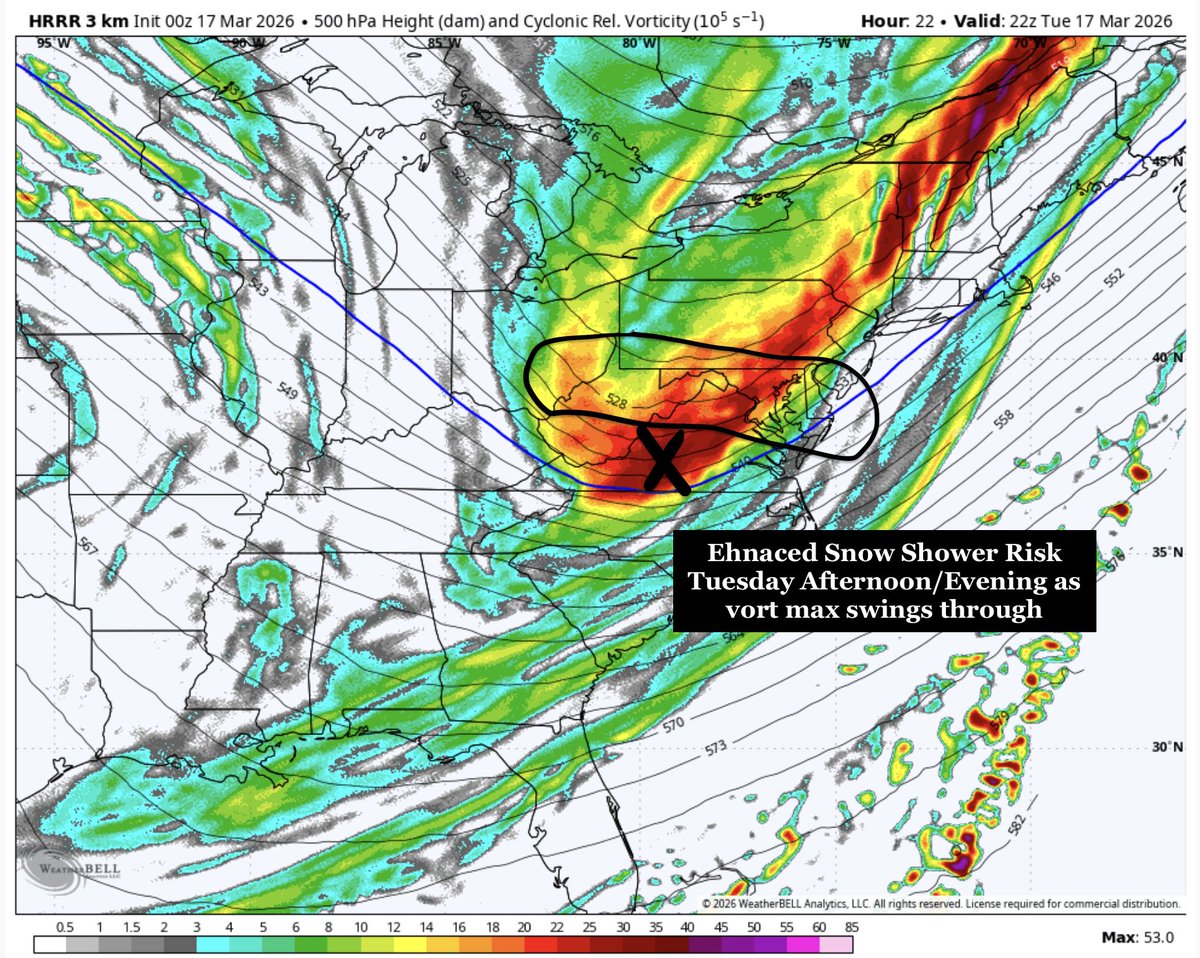
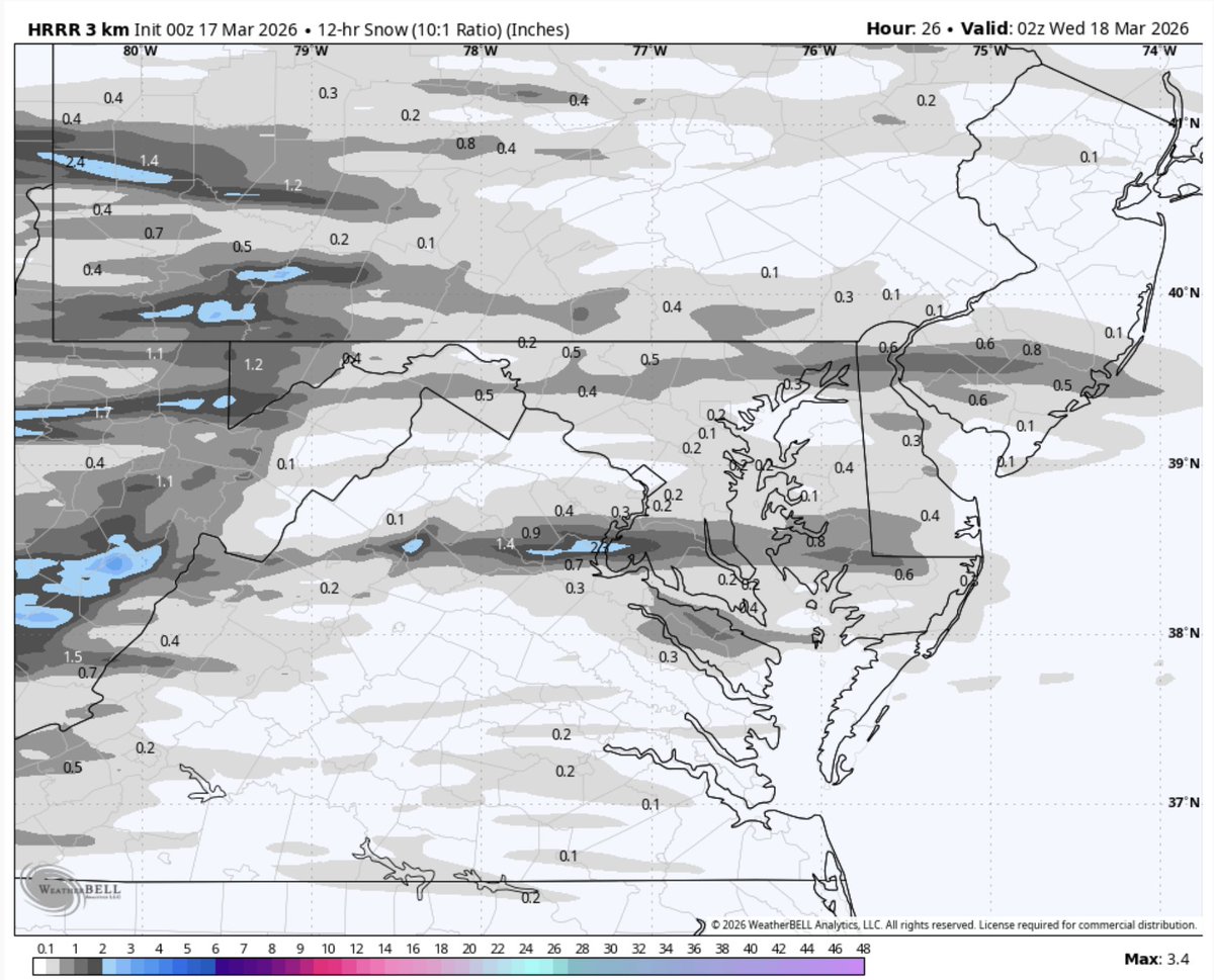
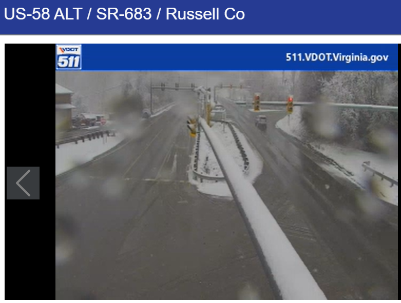
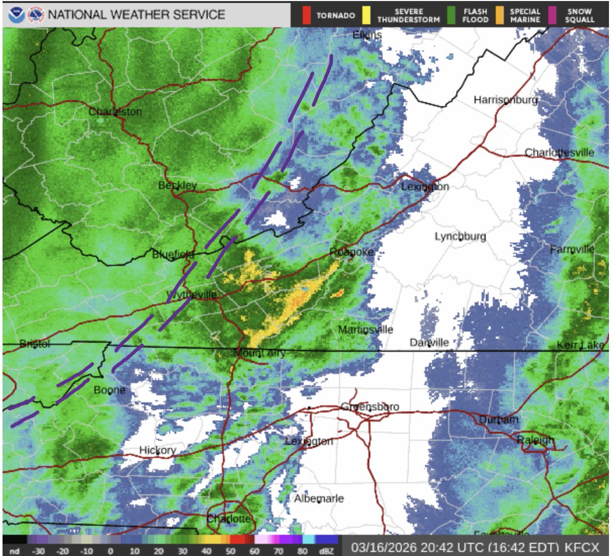
NOVAwx

5.5K posts

NOVAwx banner
NOVAwx

NOVAwx

@AwxNov

Tracking storms for a hobby, with a particular interest on NOVA

Tham gia Şubat 2021
1.5K Đang theo dõi973 Người theo dõi
NOVAwx đã retweet
NASA
NASA@NASA·
Liftoff. The Artemis II mission launched from @NASAKennedy at 6:35pm ET (2235 UTC), propelling four astronauts on a journey around the Moon. Artemis II will pave the way for future Moon landings, as well as the next giant leap — astronauts on Mars.
English
3.4K
52.1K
163.1K
9.8M
NOVAwx đã retweet
Ryan Kane
Ryan Kane@ryankanerWX·
KaneCast: Wednesday April, 1st Starting off very warm today with mostly sunny skies & temps in the upper 60s/low 70s. Highs reach the 80-85 range across the DMV with building humidity. Storms expected this afternoon/eve from 5-10pm. Isolated instances of damaging winds expected.
Ryan Kane tweet mediaRyan Kane tweet mediaRyan Kane tweet media
GIF
English
1
3
11
801
NOVAwx đã retweet
Ryan Kane
Ryan Kane@ryankanerWX·
Sunday March 29th KaneCast: - Mostly sunny today & breezy w/ highs up to 55-60 - Isolated/scattered showers Monday (not a washout) - Isolated shower/storm Tuesday (partly sunny & warm!) - Watch for T-Storms Wednesday PM/Evening - Backdoor cold front Thursday? - Showers Fri & Sat
Ryan Kane tweet mediaRyan Kane tweet mediaRyan Kane tweet mediaRyan Kane tweet media
English
1
1
17
2K
NOVAwx đã retweet
Ryan Kane
Ryan Kane@ryankanerWX·
Thursday March 26th KaneCast: - Mostly sunny skies today with highs in the mid 70s to near 80 - Breezy conditions with southwest winds in the 10-20 mph range - Great day for Orioles opening day! Go Os! - Cold front pushes through tonight with showers Friday morning #MdWx
Ryan Kane tweet mediaRyan Kane tweet mediaRyan Kane tweet media
English
0
1
12
954
NOVAwx đã retweet
Ryan Kane
Ryan Kane@ryankanerWX·
Severe Storms Possible this afternoon & evening from western Ohio into PA. Large hail & damaging winds are the biggest threats. An isolated tornado cannot be ruled out over PA. Most of the severe activity stays north of PA line, with some showers overnight for the DMV. #MdWx
Ryan Kane tweet mediaRyan Kane tweet mediaRyan Kane tweet media
English
1
1
13
1.9K
NOVAwx đã retweet
Mike Thomas
Mike Thomas@MikeTFox5·
While the west deals with a strong heat ridge, here in the East we'll do a lot of classic spring swings. Chilly➡️Warm➡️Chilly➡️Warm➡️Chilly➡️Warm Classic "drive you crazy" type weather here.
GIF
English
2
18
101
8.9K
NOVAwx
NOVAwx@AwxNov·
The snow squall army has woken up this afternoon I expect these to move into Virginia around 2-4PM Everything will clear up later tonight
GIF
GIF
English
0
0
3
197
NOVAwx
NOVAwx@AwxNov·
Still flakes flying this morning I expect this to continue for most of the day and increase in coverage during the afternoon hours as the shortwave swings through Everything will taper off later tonight
GIF
English
0
0
5
147
NOVAwx đã retweet
Ryan Kane
Ryan Kane@ryankanerWX·
Tuesday Weather Update: - Very cold day with blustery conditions (feels-like temps remain in the 20s for DMV) - Vort max swings through Tuesday afternoon/evening with snow showers (Noon-8pm) - Light coating to localized 0.5-1" possible - Snow showers pack a quick punch #MdWx
Ryan Kane tweet media
GIF
Ryan Kane tweet mediaRyan Kane tweet media
English
1
2
25
2.1K
NOVAwx
NOVAwx@AwxNov·
Definitely some juice left in the atmosphere this snow squall has some pretty decently sized flakes Wouldn’t be surprised if I wake up to another coating on my car
GIF
English
0
0
3
5.2K
NOVAwx
NOVAwx@AwxNov·
Well not a great day for the NWS got about 1-2 inches here very different from their afternoon map lol The snow squall army looks to continue into tomorrow evening some of this could leak into the piedmont
NOVAwx tweet media
GIF
English
1
0
8
486
NOVAwx
NOVAwx@AwxNov·
I’ll admit I don’t care about severe weather whatsoever but seeing everything turn white for the millionth time? Ahh it’ll never get old
NOVAwx tweet media
English
1
0
12
378
NOVAwx đã retweet
Ryan Kane
Ryan Kane@ryankanerWX·
The severe threat is not fully over. A strong cold front will pass through w/ a squall line from 8-11pm. Gusts of 20-40 mph are likely across the DMV with some 40-60 mph gusts. NW burbs will mix w/ snow as temps plummet by midnight. Tuesday will feel like winter w/ snow showers.
GIF
GIF
Ryan Kane tweet media
English
3
4
29
3.4K
NOVAwx
NOVAwx@AwxNov·
Changing over to snow here!
English
0
0
4
586
NOVAwx
NOVAwx@AwxNov·
@wx_luk3 Fingers crossed for at least white ground 🤞 Parts of SW Virginia are certainly doing quite well
NOVAwx tweet media
English
0
0
0
22
Luke Barrette
Luke Barrette@wx_luk3·
Mix of sleet and snow now in Blacksburg, VA! 5:20 pm #vawx
English
1
0
2
127
NOVAwx
NOVAwx@AwxNov·
Mix line (Purple) is moving quickly east should be a fast change over already in the low 40's here Saw some 2+ inch reports in SW Virginia certainly seems likely in the higher elevations especially with that band
NOVAwx tweet media
English
0
0
3
170
NOVAwx
NOVAwx@AwxNov·
Well the cold front definitely just passed through very windy now Temperatures will start to crash from here on out saw that some flakes were reported in Atlanta cool!
GIF
English
0
0
4
157
NOVAwx đã retweet
Mike Thomas
Mike Thomas@MikeTFox5·
Tornado Watch DROPPED early for the bulk of the DC region. Was set to expire at 7pm originally, but with the current line advancing east towards the Bay...there should be a several hour lull in the action here. Still expecting another line later tonight with the front crossing. SPC notes: "The tornado watch will be cancelled in the wake of this line of storms. Some threat for damaging convective winds with the front this evening still persists, but will be handled with an additional watch later this evening if necessary."
Mike Thomas tweet mediaMike Thomas tweet media
English
1
7
80
18K