OSINT MAP

59 posts

OSINT MAP banner
OSINT MAP

OSINT MAP

@OpenSourceMap

Developed by @Camhigby | Fighting Fog of War | Mapping the Conflict | Strikes Manually Added| Days live: 1

Tham gia Mart 2026
1 Đang theo dõi8.8K Người theo dõi
OSINT MAP
OSINT MAP@OpenSourceMap·
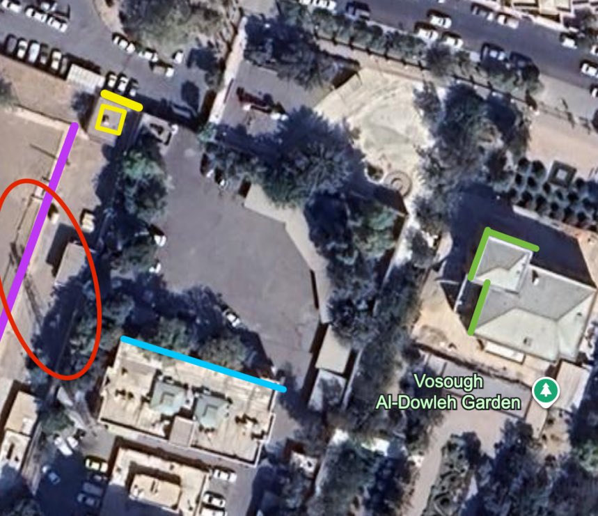
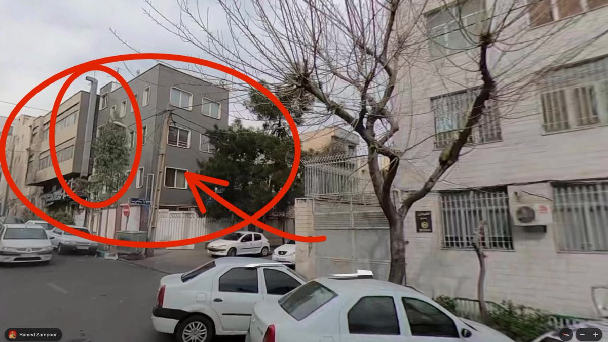
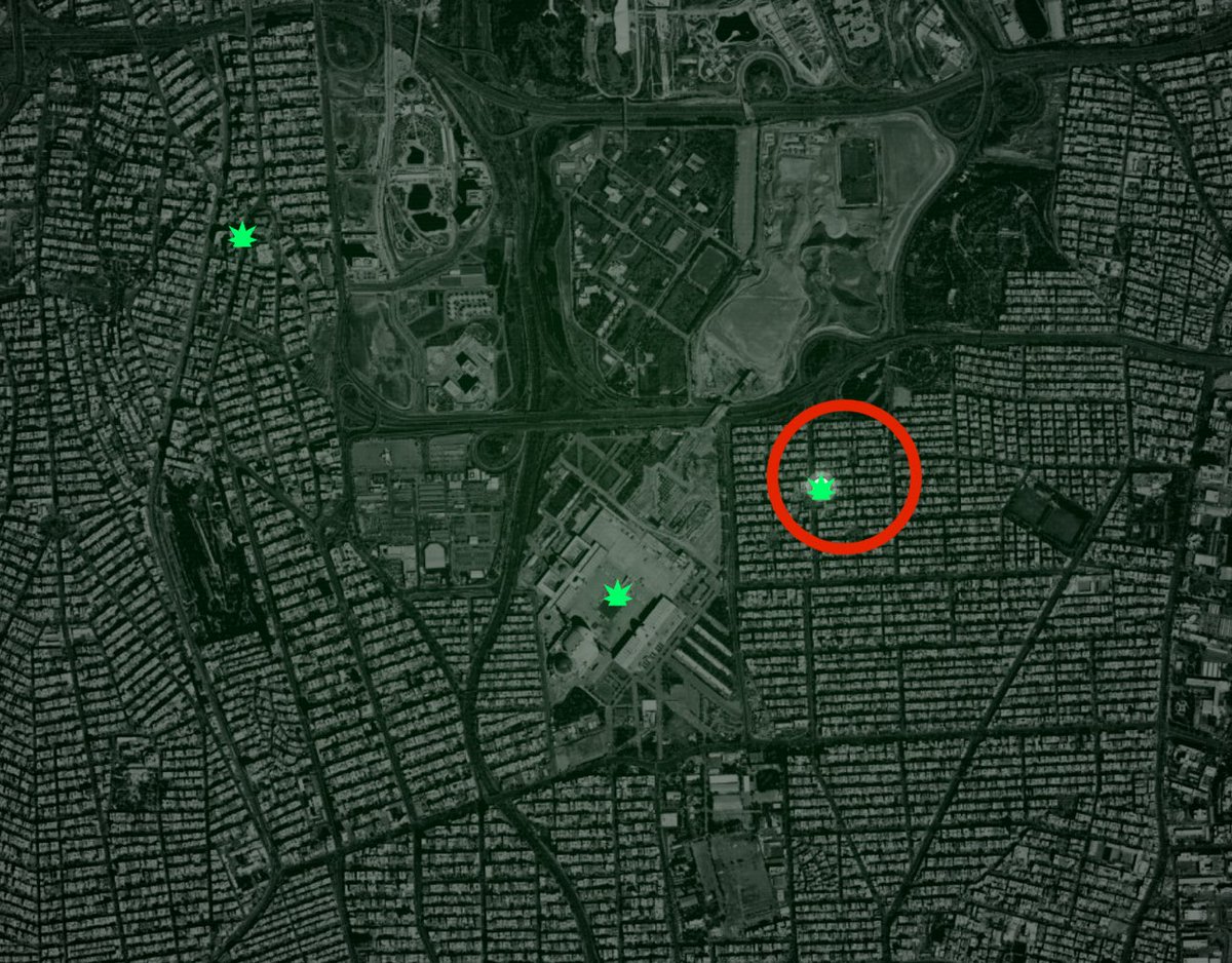
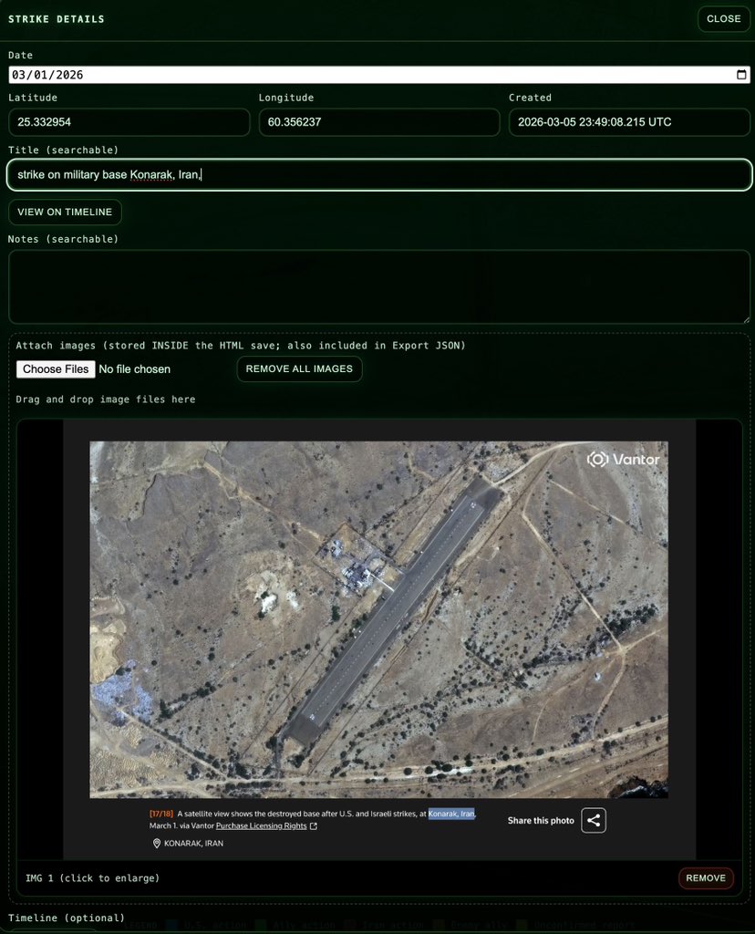
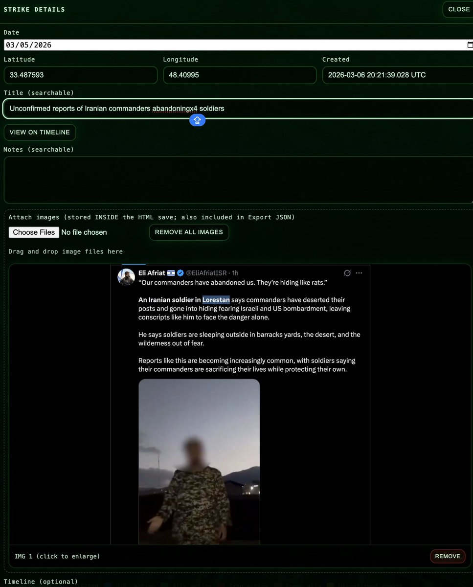
🚨 We’ve added a yellow marker to Masjid Imam Ali missile base in Lorestan, Iran to match unverified reports that Iranian commanders are ABANDONING their units there. 
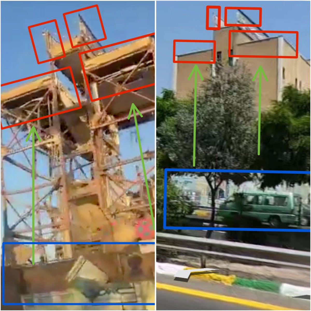
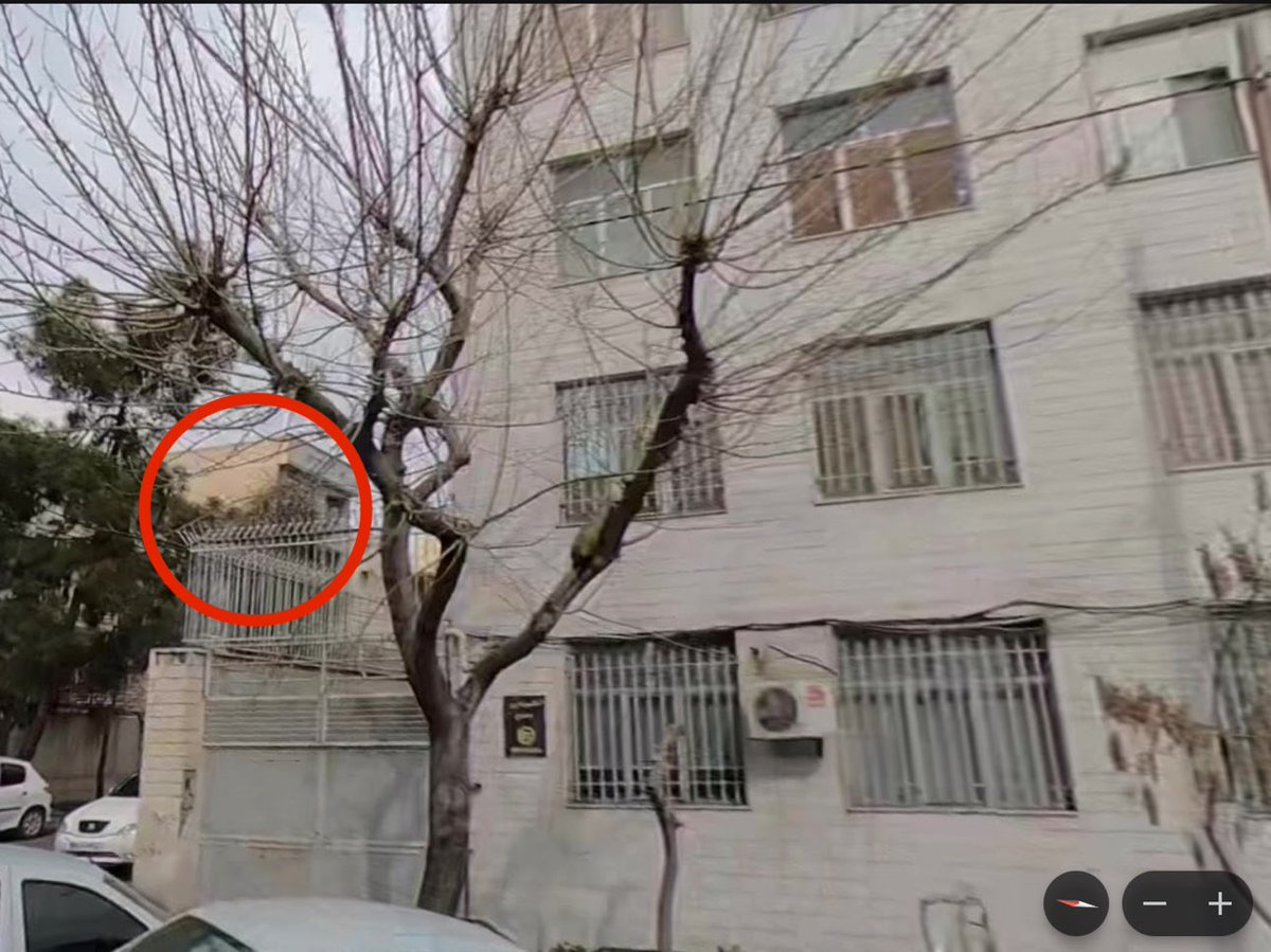
I was unable to geolocate the buildings in the video to the map, but the building types are very consistent with military installations in Lorestan. His uniform also appears identical to that of Basij forces who function as a support group at the base. 
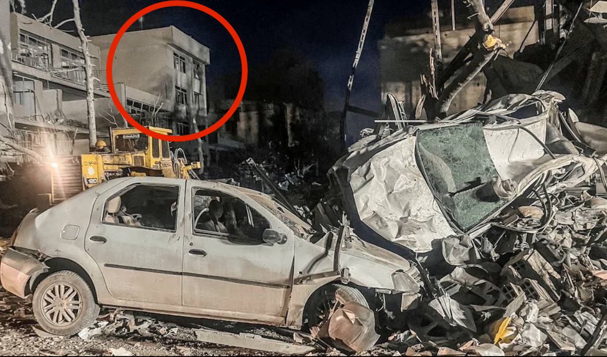
The event, if authentic likely took place at a smaller, surrounding base in the hills. I will work on finding it again later today.
OSINT MAP tweet mediaOSINT MAP tweet mediaOSINT MAP tweet mediaOSINT MAP tweet media
English
5
37
207
15.5K
OSINT MAP
OSINT MAP@OpenSourceMap·
I will revisit this report later today and geolocate if possible.
English
0
1
6
1.6K
OSINT MAP
OSINT MAP@OpenSourceMap·
We’ve added a pin to the map to match unconfirmed reports of a strike on an IRGC brigade base in Dorisan Hill in Paveh, Iran. The base reportedly sits just on the Iraq border and is likely used to conduct operations against Kurdish opposition across the line. We were unable to geolocate the base, and so the strike was placed at the base of Dorisan hill.
OSINT MAP tweet mediaOSINT MAP tweet media
English
2
8
25
2.5K
OSINT MAP
OSINT MAP@OpenSourceMap·
I feel bad for anyone who didn’t monitor the last war Israel was involved in… They don’t know that the Muslim sellouts claim Tel Aviv got nuked every 10 minutes.
English
15
49
1K
21.4K
OSINT MAP
OSINT MAP@OpenSourceMap·
What features do you guys want that the site is missing? ⬇️⬇️
English
9
0
10
3.3K
OSINT MAP
OSINT MAP@OpenSourceMap·
Exact* sorry, we’re busy plotting.
English
1
0
18
2.8K
OSINT MAP
OSINT MAP@OpenSourceMap·
EXACTL LOCATIONS: We have plotted numerous new strikes in Tehran, many using satellite imagery to corroborate. Among these new strikes are command and control centers, a hospital, and 3 sports centers. All strikes on the map are set to their EXACT location. Down to the building. The hospital appears to have suffered damage resulting from a strike on the 3rd party target - and reports indicate that the IRGC has been lodging their troops in sports stadiums following the destruction of much of their military infrastructure (which is also visible on the map) You’ll also notice that the map is now topographical and utilizes satellite imagery when you zoom in. Enjoy!
OSINT MAP tweet mediaOSINT MAP tweet mediaOSINT MAP tweet media
English
5
42
201
15.7K
Cam Higby 🇺🇸
Cam Higby 🇺🇸@camhigby·
EXTREMELY IMPORTANT: if you’re following this conflict you NEED to go to @OpenSourceMap - I have spent days mapping out the entire conflict down to the centimeter. Iranbattlemap.com is the most comprehensive tool I’ve seen, and I plot each strike manually, with verified sourcing. The ENTIRE map is interactive. Click the icon of a strike, an information window opens up. You can report strikes, if any are missing. There is also a statistics window with graphs and a timeline. When you click an event card on the timeline, it redirects you to the exact spot on the map where the event occurred.
Cam Higby 🇺🇸 tweet mediaCam Higby 🇺🇸 tweet mediaCam Higby 🇺🇸 tweet mediaCam Higby 🇺🇸 tweet media
English
55
312
1.3K
81K
OSINT MAP
OSINT MAP@OpenSourceMap·
🚨 In the past hour I have identified 3 separate police stations including FARAJA HQ in Tehran that have been utterly destroyed by joint air strikes in the city. Unverified reports were reviewed, geolocated, and confirmed. They now appear on the map and are searchable.
OSINT MAP tweet mediaOSINT MAP tweet mediaOSINT MAP tweet mediaOSINT MAP tweet media
English
2
63
284
11.4K
OSINT MAP
OSINT MAP@OpenSourceMap·
@camhigby Added to map in precise location ✅
OSINT MAP tweet mediaOSINT MAP tweet media
English
0
0
7
321
Cam Higby 🇺🇸
Cam Higby 🇺🇸@camhigby·
🚨 ANOTHER ONE: I have used geolocation to confirm the wreckage of Soleymaniyeh Police Station (121) in eastern Tehran has been obliterated. Adding it to @OpenSourceMap now. Follow me there for live geographical updates on the war.
Cam Higby 🇺🇸 tweet mediaCam Higby 🇺🇸 tweet media
English
3
60
401
9.3K
Cam Higby 🇺🇸
Cam Higby 🇺🇸@camhigby·
🚨BREAKING: Images of Republic of Iran Police Command (FARAJA) Headquarters absolutely leveled are authentic. I matched stills with street view. FARAJA falls under the command of the Revolutionary Guard, making them a wing of the military.
Cam Higby 🇺🇸 tweet mediaCam Higby 🇺🇸 tweet media
English
18
87
427
12.4K
OSINT MAP
OSINT MAP@OpenSourceMap·
Is the map working for you?
English
5
0
14
3.1K
Cam Higby 🇺🇸
Cam Higby 🇺🇸@camhigby·
🚨 CONFIRMED: Photos of Abbasabad Police Station (104) completely leveled are authentic. The surrounding buildings in images released from Iran line up EXACTLY with street view. The station was likely used as an IRGC staging site and interrogation center following the destruction of their regular headquarters.
Cam Higby 🇺🇸 tweet mediaCam Higby 🇺🇸 tweet mediaCam Higby 🇺🇸 tweet mediaCam Higby 🇺🇸 tweet media
English
12
165
855
28K
OSINT MAP
OSINT MAP@OpenSourceMap·
🚨 Satellite images emerge of the IRINS Makran forward base ship being ANNIHILATED in Iran’s Bandar Abbas. This comes as Iran’s Navy is almost completely taken out while anchored in their ports.
OSINT MAP tweet mediaOSINT MAP tweet mediaOSINT MAP tweet media
English
9
74
613
135.3K
OSINT MAP
OSINT MAP@OpenSourceMap·
It’s just donned in me that ya’ll did not have a “close” button after clicking on a strike and viewing its details. Adding now. Sorry for the annoying UI.
English
1
1
27
2.2K
OSINT MAP
OSINT MAP@OpenSourceMap·
The U.S. and Israel have DECIMATED Iran’s military capability in Konarak, on the Gulf of Oman. The whole area is packed with military bases and infrastructure. It appears we have hit it all. Check out the map: Iranbattlemap.com
OSINT MAP tweet mediaOSINT MAP tweet mediaOSINT MAP tweet mediaOSINT MAP tweet media
English
15
81
388
25.1K
OSINT MAP
OSINT MAP@OpenSourceMap·
Satellite imaging reveals that the United States struck a radar system DEEP inside of southeastern Iran at Zahedan airbase. Incredible. Now on the map. We’ve added dozens of strikes in the last hour.
OSINT MAP tweet mediaOSINT MAP tweet media
English
6
58
629
23.5K
OSINT MAP
OSINT MAP@OpenSourceMap·
Back up and running. Feature updates coming in around an hour.
English
0
0
10
1.9K
OSINT MAP
OSINT MAP@OpenSourceMap·
Doing a little maintenance. Back soon.
English
2
0
23
2.6K
OSINT MAP
OSINT MAP@OpenSourceMap·
@Jvnior Not real time. Probably not accurate. Don’t trust AI. It’s constantly inaccurate. We plot our strikes manually with sourcing.
English
1
1
3
4.2K
Jvnior
Jvnior@Jvnior·
We got AI tools to track Iranian missiles now. TAKBEEEEEEEEEEEEEEEEEEEEEEEEEEER!
English
85
321
3.6K
644.9K