Remote Sensing @ WSL
114 posts

Remote Sensing @ WSL
@WSL_RemoteSens
Remote sensing groups @WSL_research and @SLFDavos Extracting information using a variety of platforms and sensors
Birmensdorf (ZH), Schweiz انضم Aralık 2020
50 يتبع836 المتابعون


Remote Sensing @ WSL أُعيد تغريده
📢 Call for data! Seeking #RGBI imagery & annotations for #tree #species. 🌳🌲🌴Passionate about #forestry, #ecology, #biodiversity, or #DeepLearning? Help build a universal model for tree species #identification! ⌛️Deadline: 31.10.2024. ➡️ 3dforecotech.eu/activities/tre…

English
Remote Sensing @ WSL أُعيد تغريده
🌲🛰️🌳Do you know how to appropriately validate countrywide #forest disturbance maps? An extensive validation of generated maps is essential... Here we show how to do it:
academic.oup.com/forestry/advan…
#Sentinel2 @JanikDeutscher @WSL_RemoteSens @
English
Remote Sensing @ WSL أُعيد تغريده

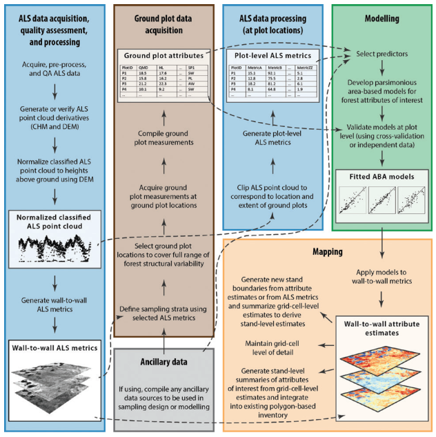
You have airborne #lidar, now what to do? 🌲📏
Find guidance:
@Joanne_C_White et al. A model development and application guide for generating an enhanced forest inventory using airborne laser scanning data and an area-based approach. #forestinventory
🔗publications.gc.ca/collections/co…
English
Remote Sensing @ WSL أُعيد تغريده
The abstract submission deadline for ForestSAT in Rotorua has been extended until 20 April.
This is your opportunity to present original research in the oral or poster format.
#ForestSAT #conference #abstracts #forestry #spatialanalysis
Submit now: buff.ly/3PxgK17
English
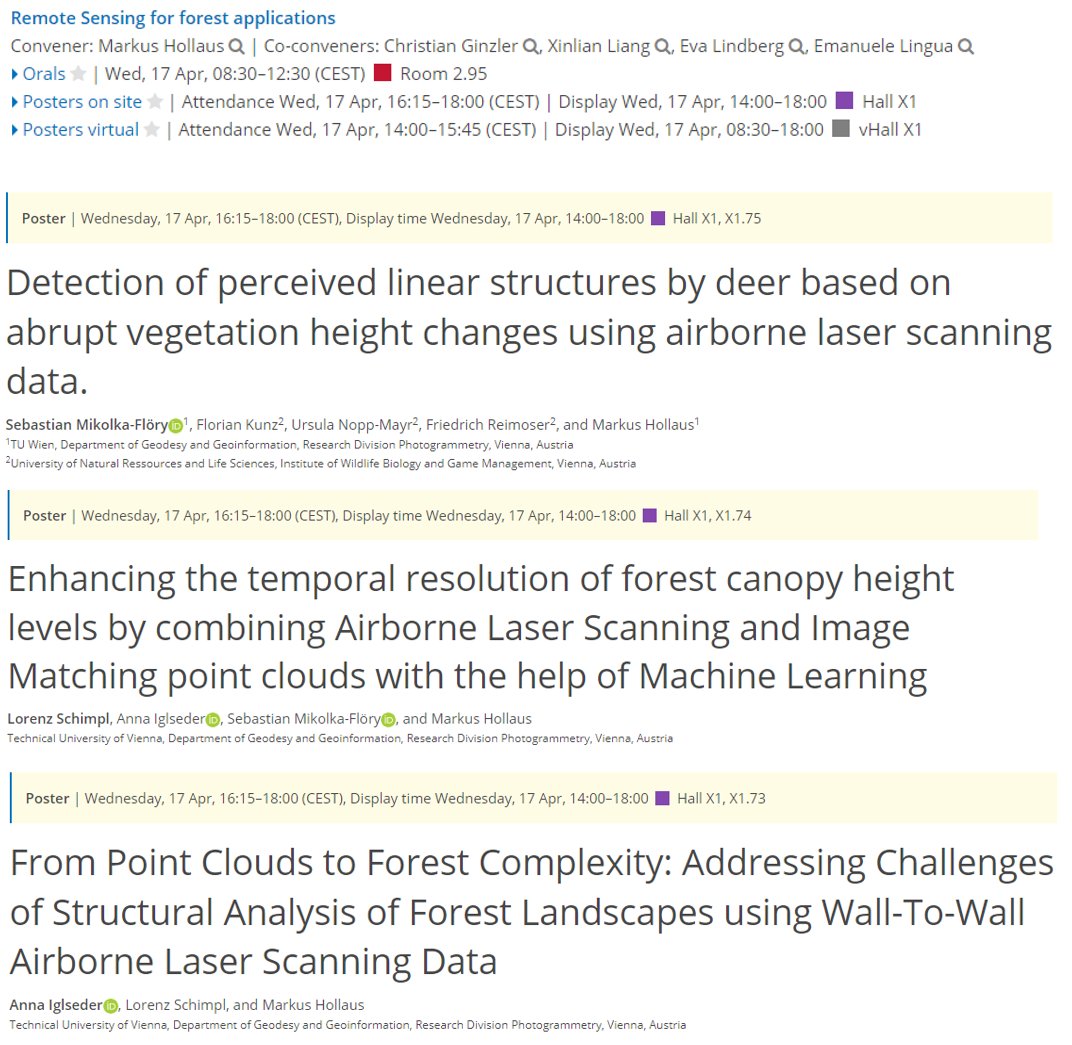
Remote Sensing @ WSL أُعيد تغريده
#EGU24 kicked off in #Vienna - a homerun for our group, as always. This year, we're prominently featured in session BG9.2, focusing on RS for forest applications. Drop by and say hi Wednesday! 👋👇meetingorganizer.copernicus.org/EGU24/session/…
English
Remote Sensing @ WSL أُعيد تغريده
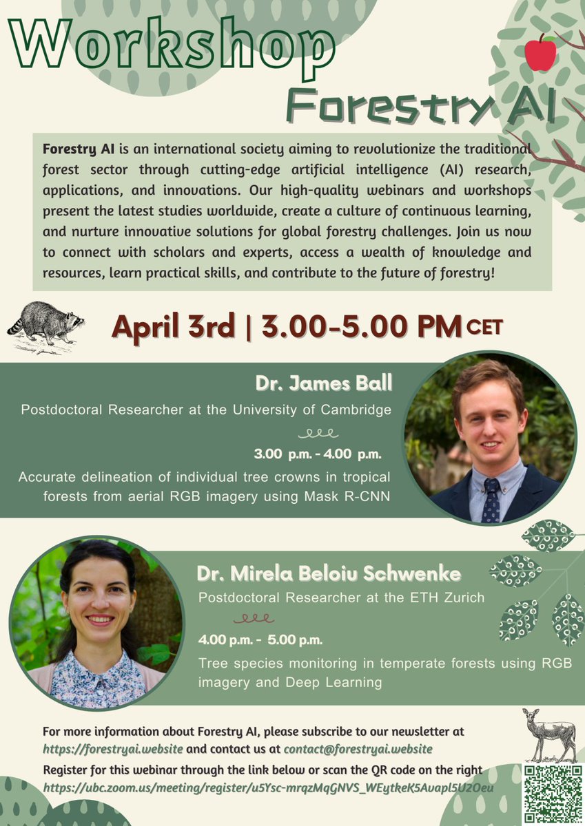
Exploring new horizons: tree species mapping with #deeplearning & #RGB imagery 🌲🌳🌱🌴Future #tree & #biodiversity monitoring methods 🧐
I'll be giving a workshop with @JgcBall at #ForestryAI
If you are interested, join us 👩🏾💻🧑🏽💻👩💻⬇️
Registration: forestryai.website/events
English
Working on an exciting new topic on nighttime light (NTL) with high potential for ecological applications, #SDGSAT

English
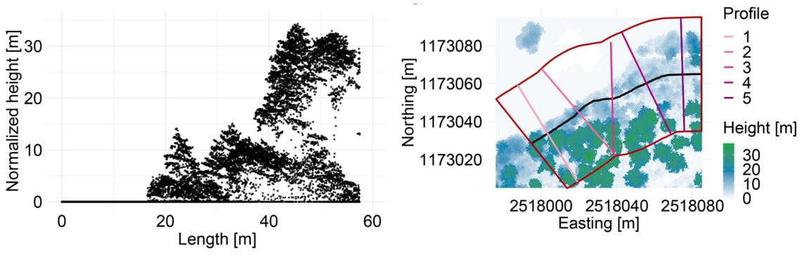
Assessing the structure of #forest 🌳🌲edges is key for understanding their ecological value and supporting a purposive management. See the latest paper @MoBruggisser how to do it with standard leaf-off airborne laser scanning data:
doi.org/10.1016/j.ecol…
English
Wanna join our team?
Open internship position for 6 months @WSL_RemoteSens dealing with an intriguing topic: Light emissions and remote sensing.
apply.refline.ch/273855/1593/pu…
English
Have a look at the intensity maps. They can be found here:
doi.org/10.16904/envid…
@EnvidatService
English
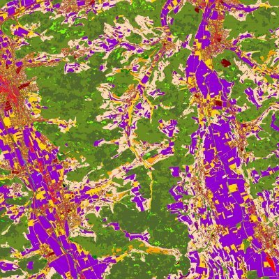
We mapped grassland-use intensities across Switzerland based on satellite time series. The resulting maps explained biodiversity patterns in Swiss grasslands well. 🛰️
#Sentinel2 #Grassland #LandUse
@DomiWbr @MarcelSchwieder @KochTiziana @WSL_research
doi.org/10.1002/rse2.3…
English
We're looking for a scientist in the field of mass movements. Want to join us @SLFDavos for this exciting tenure track position?
#RemoteSensing #permafrost
#JobAlert #TenureTrack @WSL_research
apply.refline.ch/273855/1550/pu…
English
Remote Sensing @ WSL أُعيد تغريده
Great forest workshop today @esrischweiz in Zurich. I was invited to present our latest #forest research from @WSL_RemoteSens . Interesting presentations, good mix of the audience and a rich apéro 👍
esri.ch/de-ch/events/a…
English
Remote Sensing @ WSL أُعيد تغريده

New research article: Spatially continuous snow depth mapping by aeroplane photogrammetry for annual peak of winter from 2017 to 2021 in open areas doi.org/10.5194/tc-17-…
English
Remote Sensing @ WSL أُعيد تغريده
@Tree_Mortality Thanks to amazing data contributors, the first version of the database on insect and disease disturbance in European forests (DEFID2) is now online - read all about it in the open access paper onlinelibrary.wiley.com/doi/full/10.11…
English
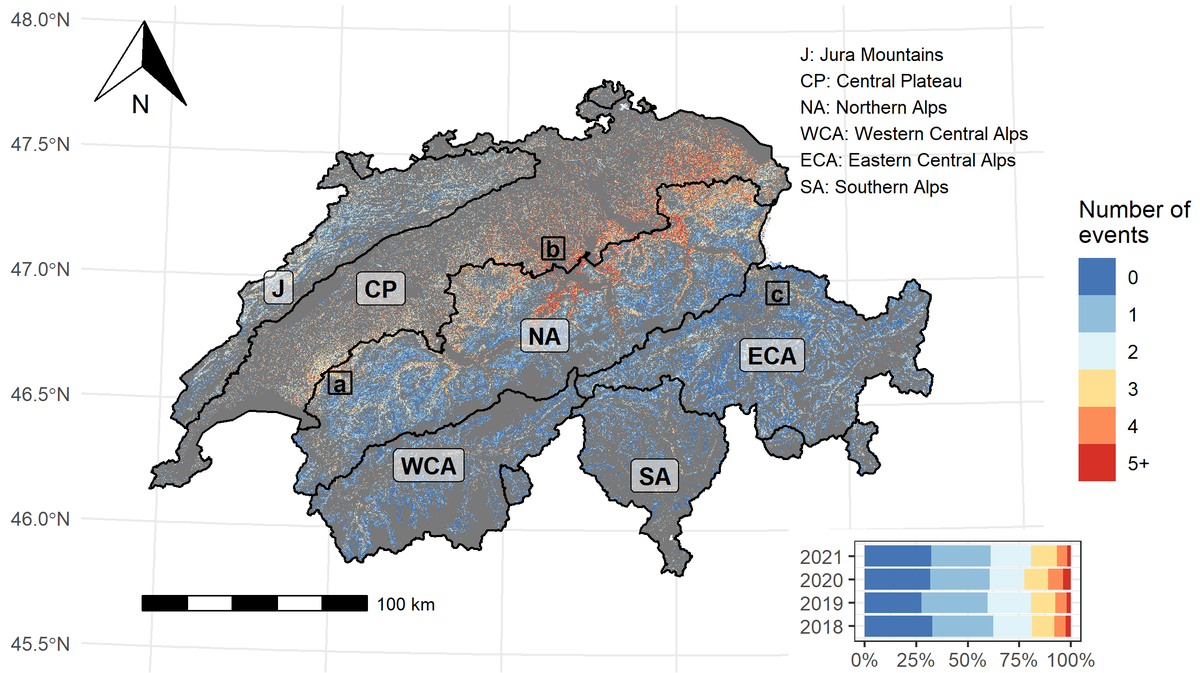
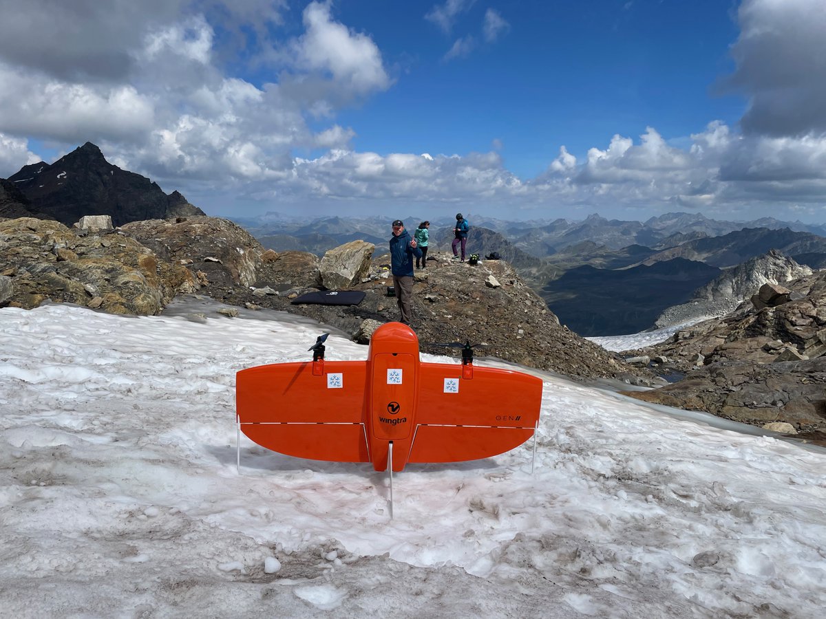
Crumbling Piz Buin Pitschen: Mapping slope instabilities for risk assessment in a breath-taking landscape! #CERC
@SLFDavos @WSL_research @DamesOfDrones @Wingtra

English