mookzy
17.7K posts


mookzy
@Mookzy
Aspiring Sports Media | Offering a Vast Array of Opinions that Represent Me and Only Me | H.S ⇔ NCAA ⇔ NBA | #LakeShow | #HiveMentality
Florida, USA Se unió Ağustos 2018
108 Siguiendo494 Seguidores

JJ Redick on why the Lakers haven't featured Deandre Ayton more:
"He's having trouble catching the ball. We ran a bunch of plays for him. He's just had trouble catching the ball."
English
@WeatherProf I have a question; With an active Pacific hurricane season upon us, could that increase the amount of crossover storms that could reemerge in the Atlantic and cause problems? (e.g Milton
Thanks!
English

You’ll be hearing a TON about El Niño over the next year because it’s gonna be a behemoth- possibly the strongest on record judging by our seasonal models. So a short lesson here… Take a look at this side by side. Left: January with cool tropical Pacific waters in the central & east Pacific. That was our fading La Niña. Right: Now waters are warming near Peru… that’s often where we first see signs of El Niño emerging. Those warm red colors will continue to fill in over the east, then central Pacific. The warmth is coming eastward from the Pacific’s warm water warehouse called the “Indo-Pacific Warm Pool”. This displacement of warm water may seem meager, but the Tropical Pacific itself is HUGE because it’s on the Equator (where the ocean is widest) in the biggest basin on Earth, so when heat moves from one side to the other, builds up, and is released into the atmosphere there, it changes global weather patterns significantly. Because it’s predicted to be so strong, the warming there will likely overwhelm the adjacent areas, like the Caribbean and much of the Atlantic Basin. So I do expect a slower than normal Atlantic #hurricane season. Then as the El Niño grows into next fall/ winter the subtropical jet should fuel heavy rain and severe weather for the Deep South, Gulf and #Florida. Beyond our local impacts, El Niño can be a God sent for certain areas (good monsoon rain this summer in the arid US SW) or it can be the devil, with punishing drought (Indonesia) or floods (Peru) and it decimates fishing in Peru as well as life in the Galápagos Islands due to reduced food supply.

English

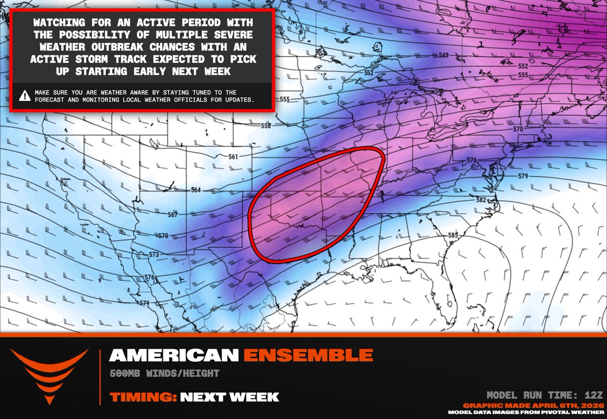
THE MOST ACTIVE PATTERN FOR TORNADOES SINCE 2011 AHEAD
A historically active April for severe weather and #tornado outbreaks appears possible this month across the central ant southern Great Plains. This active stretch will begin Friday/Saturday across the Texas Panhandle and southern Plains on Sunday, then ejecting northeast on Monday.
A train of large scale troughs are upstream fed by the positive North Pacific Oscillation that has persisted since 2023. Round after round of severe weather and tornadoes appears likely through much of the month of April 2026.
English
2K never bans anyone for no reason lol, how the community still believes anyone who claims to be innocent is beyond me.
Strive@StriveAP2k
I want to apologize to anyone that vouched for me or supported me this weekend. I was in a tough spot financially and mentally and I made a mistake. I also wanna apologize directly to Ty for being a hypocrite. Money can change people and it changed me for the worse.
English


@HardRockBet “AND THE BLAZERS WIN THE SERIES, FOR THE FIRST TIME IN 14 YEARS!”
one of my favorite calls ever, definitely the start of dame time.
#HardRockBet
GIF
English

WIN A $100 BONUS BET!!
1️⃣ Follow us
2️⃣ Comment #HardRockBet with your favorite all-time buzzer beater
3️⃣ Admin will pick their favorite 10 replies

English


The Milwaukee Bucks are waiving Cam Thomas just weeks after signing him, sources tell ESPN.

English

Always freaky to see these. The faces of powerful Hurricanes on satellite. This was Cyclone Narelle last week, with a 925mb pressure, Major CAT 4 US level. What's crazy is they spin clockwise because they are below the equator. Storms on this side spin counter-clockwise. But the faces remain and look eerily the same. Narelle ended up making landfall in Queensland, Australia.

Oldsmar, FL 🇺🇸 English

Just in: Detroit Pistons star Cade Cunningham has been diagnosed with a collapsed lung and is expected to miss an extended period of time, sources tell ESPN.

English