Tweet Disematkan
CocoasCola
2.4K posts
CocoasCola
@CocoasCola
Just a casual person using Twitter. Currently a weather enthusiast and working up with studying a bit of space weather as well.
Bergabung Şubat 2016
4.1K Mengikuti967 Pengikut

CocoasCola me-retweet

Storm Recap: NE IL. In order:
1. Aroma Park EF3
2. Possible satellite (or re-emergence) of Aroma Park (EF3/UNK)
3. Separate rope (had a power flash before video) (UNK)
4. Likely anticyclonic tornado in same area (UNK)
@NWSChicago, have you seen evidence of these tornadoes?
English
CocoasCola me-retweet

Zoomed-in, 1-minute loop leading up to Melissa's record-tying destructive landfall - notice the Air Force plane circling in the eye after experiencing severe turbulence before leaving the storm:
English
CocoasCola me-retweet
Multi-panel view of the last few days of Hurricane Melissa:
↖️ GOES-19 infrared brightness temp
↗️ GOES-19 visible satellite
↙️ Hurricane hunter planes & flight paths
↘️ Recon-derived flight level wind swath
⬇️ Estimated minimum pressure from recon dropsondes
English
CocoasCola me-retweet

CocoasCola me-retweet
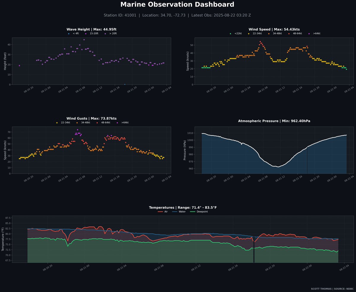
Taking a closer look into the NDBC Buoy 41001 Data, and it's been on quite the ride to say the least as Hurricane Erin was passing very close to it.
English
CocoasCola me-retweet

@WX867490 @doomhaMwx Unfortunately doesn't seem like it, captures like this from Landsat are quite uncommon.
English

@CocoasCola @doomhaMwx Did this capture Hurricane Patricia of that year? This is stunning!😳
English
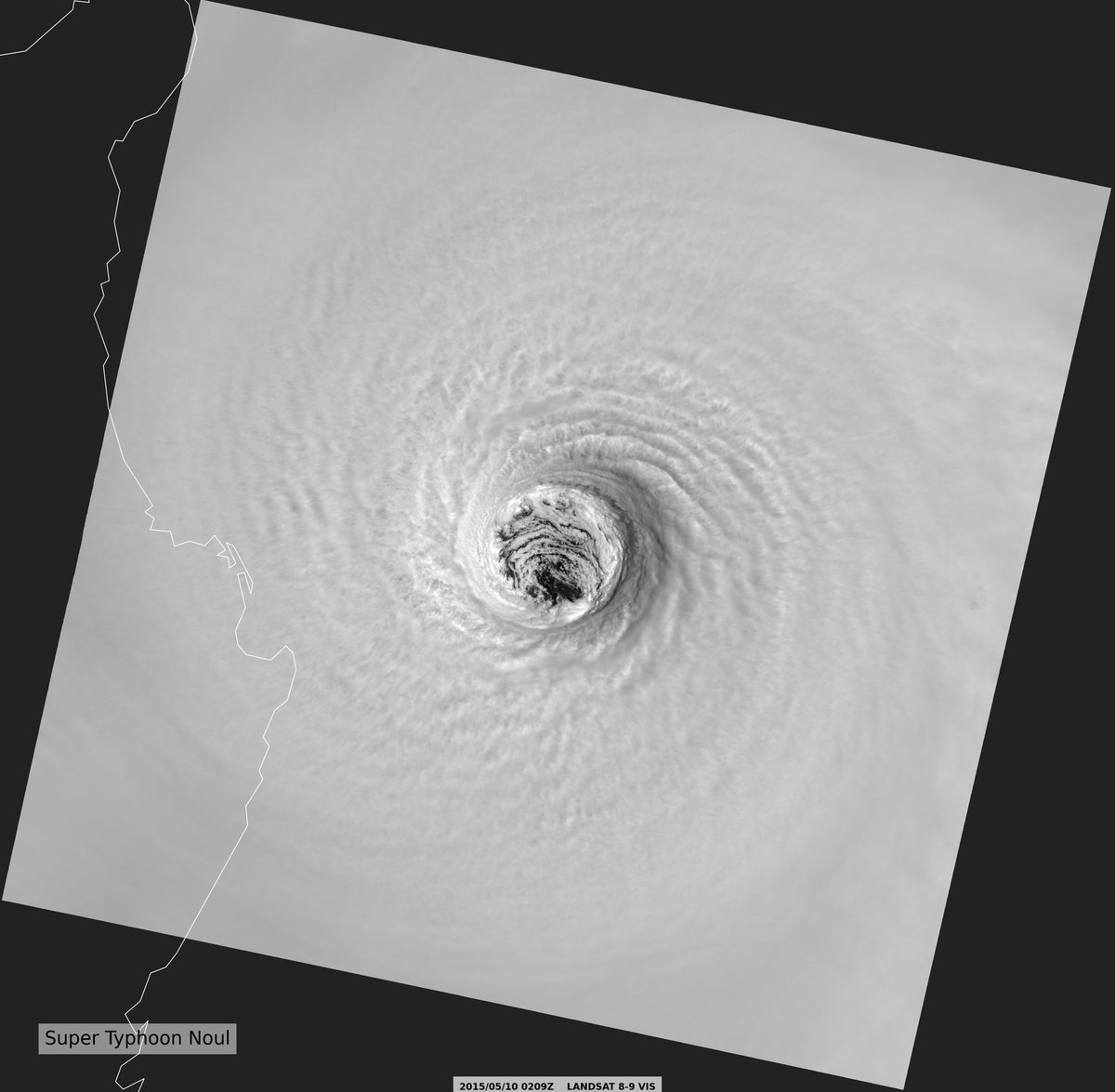
Incredible view of Super Typhoon #Noul back in 2015, the stadium effect is very very notable here as it was captured by Landsat-8. Many thanks to @doomhaMwx for pointing me towards this data back in November.

English
CocoasCola me-retweet

Cyclone #Vince from earlier this year, sampled by the EarthCARE satellite!
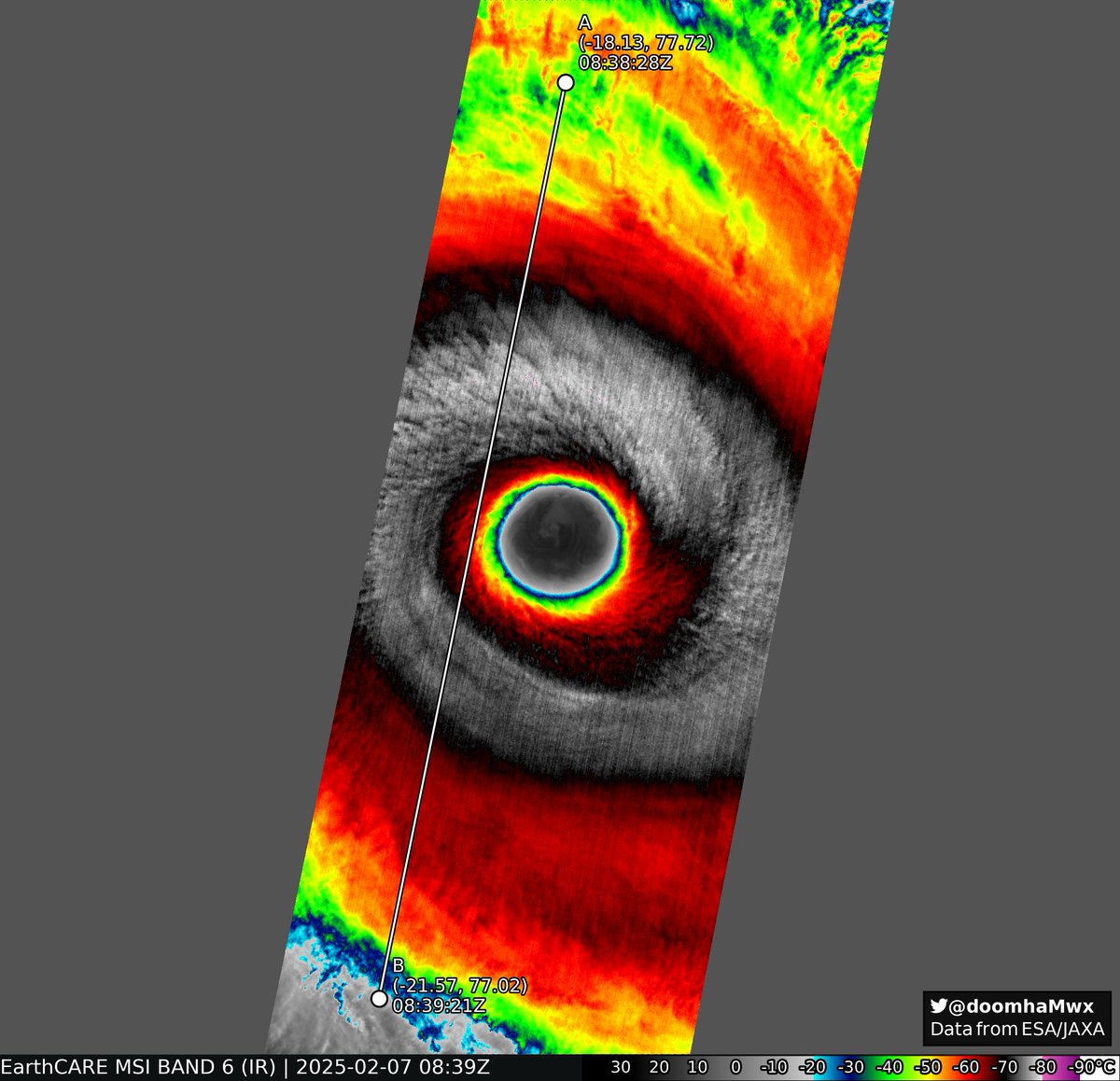
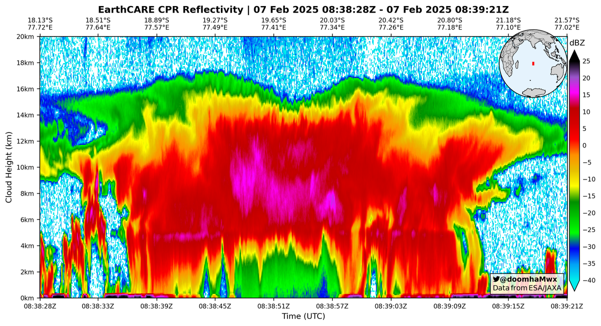
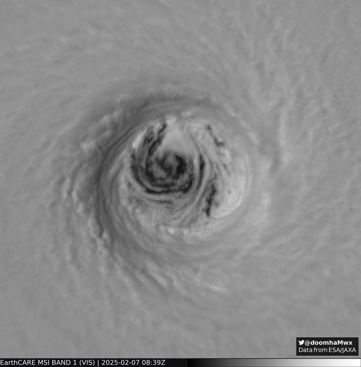
ESA's EarthCARE mission@esa_earthcare
Incredible new images from EarthCARE! 🌀 A rare glimpse into the eye of Tropical Cyclone Vince, thanks to our multispectral imager, gave us a crisp picture of the fine-scale structures in and around the eye wall and recorded some remarkable features. earth.esa.int/eogateway/succ…
English
CocoasCola me-retweet
Here's a snapshot of some of the processed I/Q from @raxpol!

Robby Frost@robbyfrostwx
WOW!!! We had an amazing data collection in @raxpol Thursday, scanning a dozen or more tornadoes west of Lubbock, including the dusty Morton wedge tornado. A quick glance and lazy dealiasing shows we sampled 55 m/s winds less than 200 meters AGL. Inspection of the 1 degree...
English
CocoasCola me-retweet

Over the past few days, I ran a 500 meter sim. of Hurricane Maria's RI in 2017. This simulation resembled reality pretty well on track and intensity (Model 906mb, Reality 908mb).
It even got the eyewall replacement cycle, a process that many models struggle to resolve today.
English
CocoasCola me-retweet

Never seen before perspective of a tornado in Arnett, OK by our research drone on May 18th. Watch the full video in the link below:
English
CocoasCola me-retweet

On this day 12 years ago, the last EF-5 rated tornado impacted Moore, Oklahoma.
Multiple nearby radars captured this tornado from start to end, including OU’s PX1000 mobile radar at very high spatiotemporal resolution (20 second samples at 30m resolution!) -
English
CocoasCola me-retweet
The eye of the Arnett, OK tornado, captured by one of our UAVs as it collected scientific data on the environment within.
English
CocoasCola me-retweet
CocoasCola me-retweet
Catching the Vortex!
During this week’s buoy drop test mission, aircrew from the 53rd Weather Reconnaissance Squadron captured a stunning view of wake vortex in action.
Wake turbulence forms when an aircraft produces lift, creating two powerful, counter-rotating vortices trailing from the wings. It’s an incredible sight.
Just another day in the sky for the Hurricane Hunters as they prep for the 2025 hurricane season.
#HurricaneHunters #53WRS #WakeVortex #ReserveReady
English
Finally got around to looking at Tropical Storm Erin from 2007, this storm decided to intensify slightly over Oklahoma and this was the view from MPAR.
English
@mark_debruin Hi Mark, quite a times past since this post was made. Do you happen to still have these project files for matlab?
English

Today I learned: Radar resolution is more a function of how the data is processed rather than radar hardware. So with the original IQ signal you can actually up the resolution as much as you want (at the cost of data quality). This one goes all the way back to KOUN May 9, 2003!

English
CocoasCola me-retweet
High-resolution tornadogenesis augmented by convection merging into the updraft on our X-band on the early morning of April 3rd @CameronJNixon
English
@JoshO_wx @ReedTimmerUSA TTUKa2 witnessed some very incredible wind turbine interaction in the wind, can't wait to sift through this data when it's available! Good work!
English

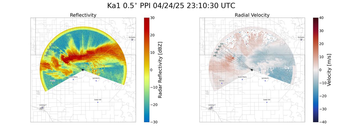
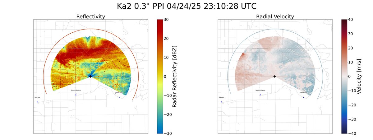
@ReedTimmerUSA Here is some more data from both of the TTUKa radars at the same time. Ka1 is running a lower PRF at 0.5deg PPIs with a range of 7km to the anticyclonic tornado, leading to a height of about 60m AGL. Ka2 is running a higher PRF at 0.3deg PPIs with the same range = 35m AGL.
English
Here’s our Ka data from the 4/24 Silverton tornado. I’ll let y’all decide which way it was spinning #easyanswer #txwx #tornado

English