NWS Chicago

49.7K posts

NWS Chicago banner
NWS Chicago

NWS Chicago

@NWSChicago

Official X account for the National Weather Service Chicago. Details: https://t.co/WJlrehSqTV

Romeoville, IL Katılım Temmuz 2012
1K Takip Edilen195.7K Takipçiler
NWS Chicago
NWS Chicago@NWSChicago·
Patchy fog will result in localized reduced visibilities below 2 miles away from Chicago. Visibility will improve through mid morning. #ILwx #INwx
NWS Chicago tweet media
English
0
4
32
9.2K
NWS Chicago
NWS Chicago@NWSChicago·
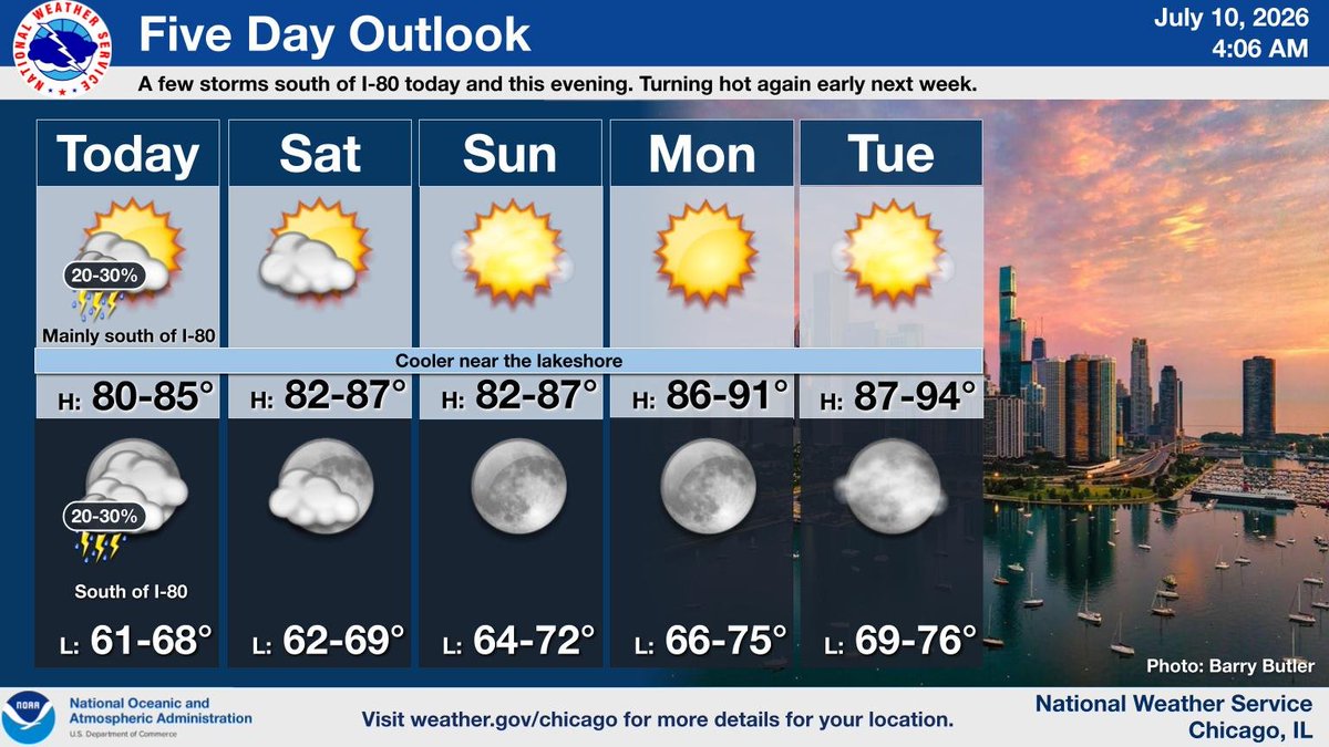
[4:10 AM CDT 7/10] A few showers and storms will be possible this afternoon and evening, mainly south of I-80. Hot and generally dry conditions will return early next week. #ILwx #INwx
NWS Chicago tweet media
English
0
6
36
7.9K
Mark Meyer
Mark Meyer@MarkMeyerWx·
@NWSChicago Lots of small and a few medium sized branches down. Haven’t seen any real damage yet. The strongest downburst winds only lasted 5-10 seconds or so and looks to be in a pretty isolated area (right where I was).
English
1
0
0
80
Mark Meyer
Mark Meyer@MarkMeyerWx·
Feisty microburst winds of 50-60 mph and small hail on the northside of Valpo. @NWSChicago
English
1
0
2
2.8K
NWS Chicago
NWS Chicago@NWSChicago·
@wx_MatthewG It is a nice little anticyclonic supercell! Great pictures, and thanks for sharing!
English

0
0
5
1.7K
NWS Chicago
NWS Chicago@NWSChicago·
Scattered showers and storms tonight, followed by isolated storm chances Friday and Saturday south of I-80. Hot and dry conditions are expected early next week. #ILwx #INwx
NWS Chicago tweet media
English
0
9
47
11.8K
NWS Chicago
NWS Chicago@NWSChicago·
(🧵2/2) Aside from the showers/storms, fog is possible late tonight especially near Lake Michigan. Shower and storm chances linger through Saturday but focus mainly south of I-80. Dry and warmer weather returns for the rest of the weekend through early next week. #ILwx #INwx
NWS Chicago tweet media
English
0
6
30
6.6K
NWS Chicago
NWS Chicago@NWSChicago·
(🧵1/2) Scattered showers/storms are expected across the area today, mainly during the PM hours, and will be capable of torrential rainfall which may lead to localized flooding. Gusty to locally damaging winds are also possible with the strongest storms. #ILwx #INwx
NWS Chicago tweet media
English
2
15
71
15.2K
NWS Chicago
NWS Chicago@NWSChicago·
Scattered storms may develop Thu afternoon and eve. Though the coverage is not expected to be widespread, conditions are favorable for torrential rainfall with any storm. This could lead to flooding if storms occur over the same areas that experienced flooding last weekend.
NWS Chicago tweet media
English
0
13
61
14.1K
NWS Chicago
NWS Chicago@NWSChicago·
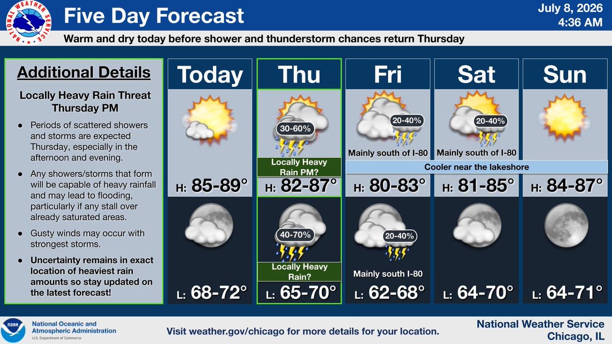
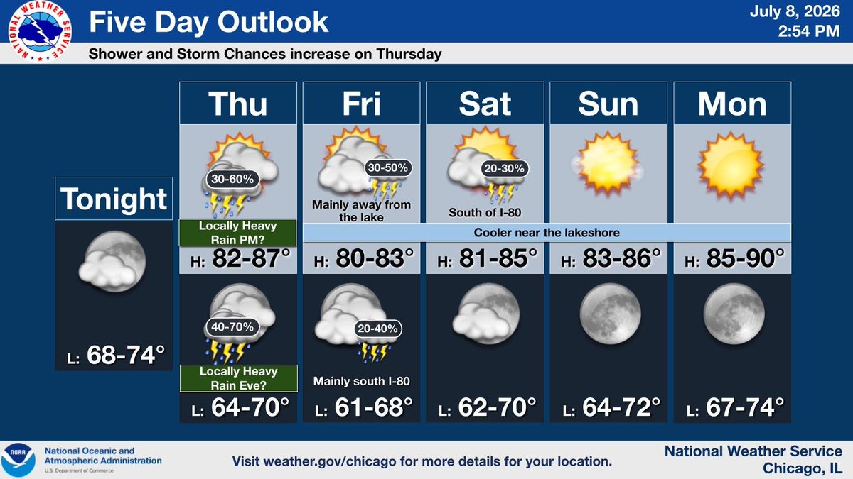
Shower and thunderstorm chances will increase on Thursday, with the potential for locally heavy rain. Storm chances will then gradually shift south of the area through Saturday, followed by dry and warm conditions heading into next week.
NWS Chicago tweet media
English
0
9
54
12.5K
NWS Chicago
NWS Chicago@NWSChicago·
A warm and dry day ahead before shower/storm chances return Thursday. There remains a potential for locally heavy rainfall Thursday afternoon-evening which could result in flooding, but confidence in where this develops remains low. Stay tuned! #ILwx #INwx
NWS Chicago tweet media
English
0
15
67
14K
NWS Chicago
NWS Chicago@NWSChicago·
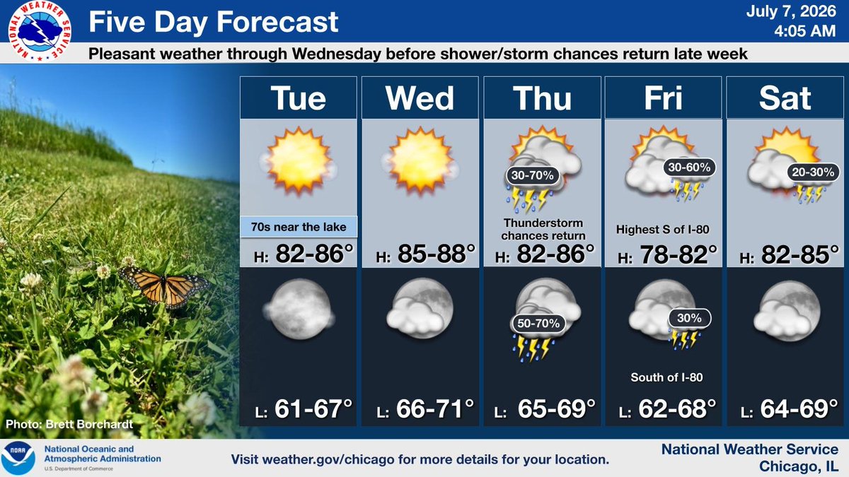
Seasonable temperatures and dry conditions will continue through tomorrow, while shower/storm chances return Thursday-Friday, including the potential for locally heavy rainfall. Stay tuned for updates! #ILwx #INwx
NWS Chicago tweet media
English
1
13
54
20K
NWS Chicago
NWS Chicago@NWSChicago·
An Air Quality Alert is in effect Wednesday for northwest Indiana due to unhealthy ozone levels. Air quality is expected to be at unhealthy levels for sensitive groups. Consider limiting prolonged outdoor activity. #INwx
NWS Chicago tweet media
English
1
5
24
10.2K
NWS Chicago
NWS Chicago@NWSChicago·
Seasonable temps and dry conditions will persist through Wed, though a lake breeze will result in cooler temps near the lakeshore this afternoon. Shower/storm chances return Thu-Fri, including the potential for locally heavy rainfall. Stay tuned for updates! #ILwx #INwx
NWS Chicago tweet media
English
1
10
73
12.4K
NWS Chicago
NWS Chicago@NWSChicago·
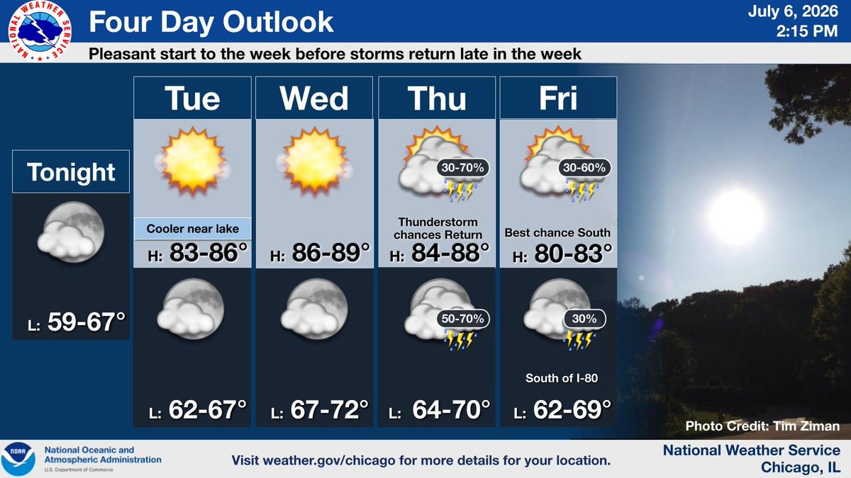
Temperatures closer to normal with dry conditions are expected the next few days with shower and storm chances returning later in the week. #ILwx #INwx
NWS Chicago tweet media
English
0
8
52
11.2K
NWS Chicago
NWS Chicago@NWSChicago·
Cooler today with generally dry and more seasonable conditions expected the next few days. Shower and storm chances return later in the week. Breaking waves to 2-4 feet are expected at southern Lake Michigan beaches today. Extra caution is advised for swimmers. #ILwx #INwx
NWS Chicago tweet media
English
0
15
74
13.5K
NWS Chicago
NWS Chicago@NWSChicago·
Isolated/scattered slow-moving showers/thunderstorms will continue mainly west of the Fox Valley and south of the Kankakee River. Localized heavy rainfall may lead to minor flooding of low spots. Activity will diminish this evening. #ILwx #INwx
NWS Chicago tweet media
English
0
10
58
14K
NWS Chicago
NWS Chicago@NWSChicago·
A relatively drier and cooler pattern will prevail through the middle of the week. Chances for thunderstorms will return by Thursday. #ILwx #INwx
NWS Chicago tweet media
English
0
9
63
12.8K