
Jennifer Hannux
9.6K posts
Jennifer Hannux
@VermontJen
Vermonter by choice. Photographer of all things outdoors and pretty. RN, runner, biker and Mom. Lover of health/wellness. And I talk about the weather, a lot
Hartland, Vermont 가입일 Mart 2009
658 팔로잉3.8K 팔로워

This will be a blizzard people speak of for generations and probably inspire a whole new set of young meteorologists!
English
@ContentWxGuy Is there a specific reason this happens? I feel like there’s some physics/math equation that would elude to a storm doing this
English

@VermontJen Storm reaches a northern point, kind of stalls and loops in place, then departs.
Tends to add multiple hours of high end impacts to the W/NW of the loop.
English
Good Afternoon. A warm system born will try to follow its birth right thermals. In this case warm.
Again room for change though nothing suggests a coastal crawler throughout the event as yet.
Blizzard loop a certainty somewhere.
Loose ideas presented if this tends to be the track

English
@_jwall Yes, and add in snow accumulation maps and model runs from “similar” storms in the past. 🤣
English

Please keep posting snow accumulation maps I need my feed cluttered more
English

Very chilly morning here in the Meadow 🥶 So far this is the lowest temp of 2026! We might get colder Friday morning.
Fun fact; 2023 was the coldest in the last five years here with a low of -23°F on Feb 4th.


English
@Eweather13 Are you going to be out on the islands for this one? 😆
English
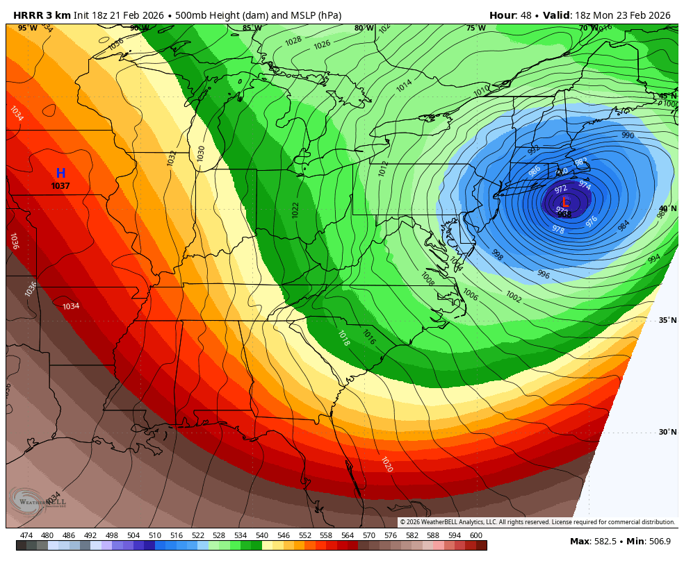
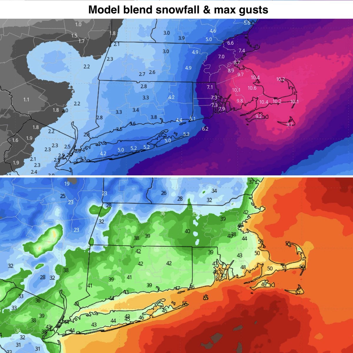
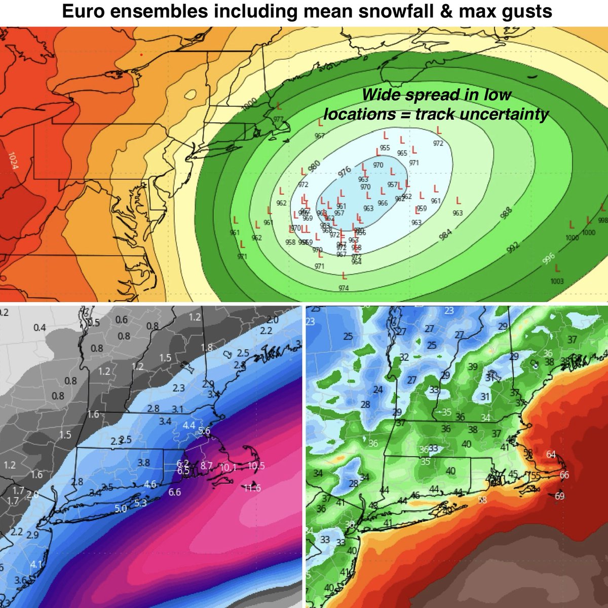
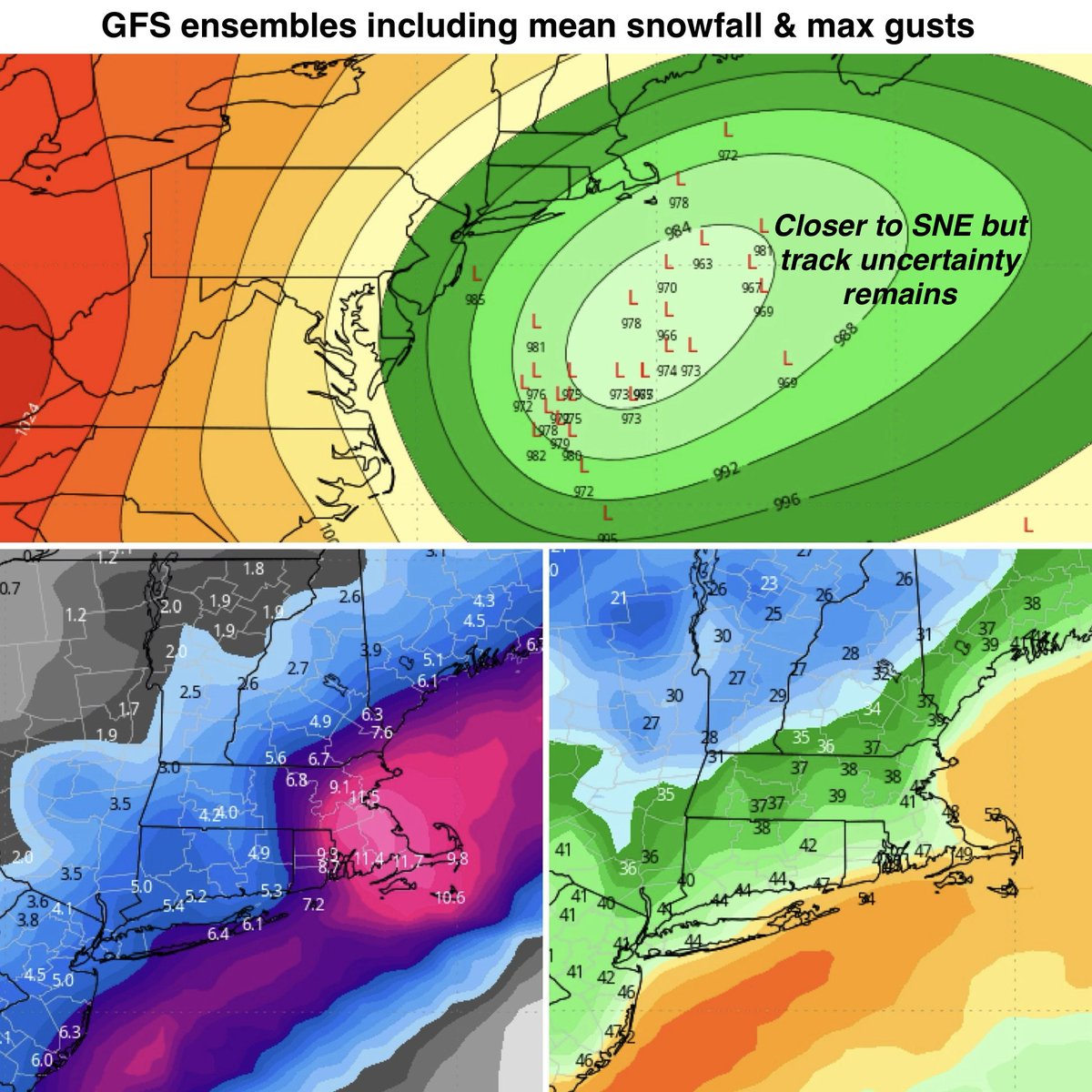
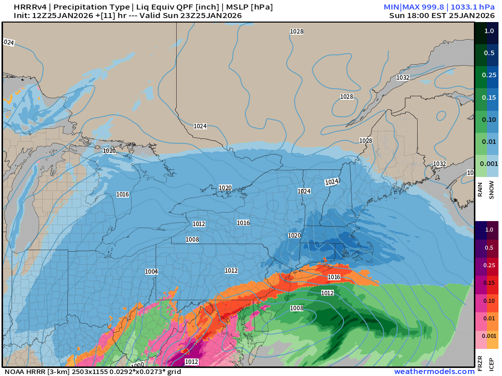
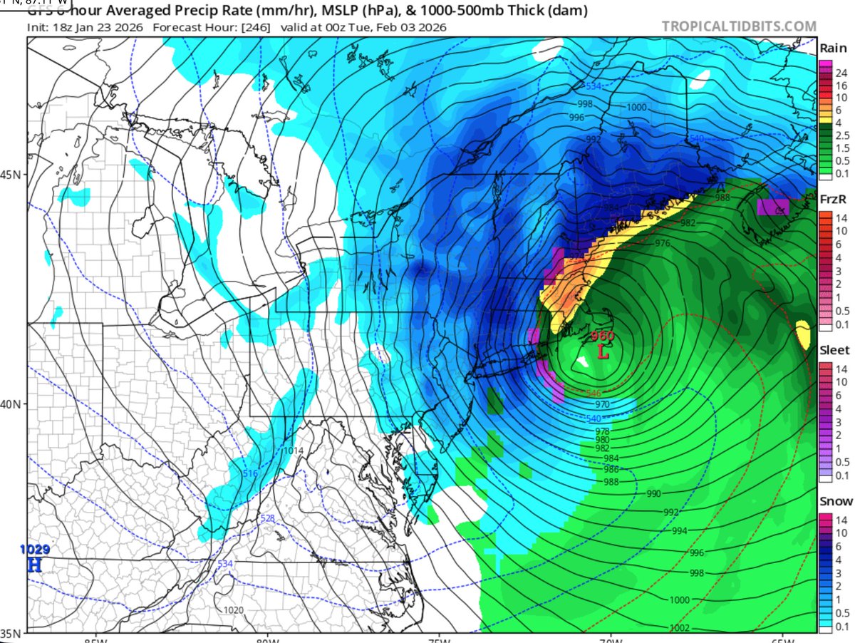
❄️💨🌊 Ocean storm: Confidence is high that this storm will form and undergo bombogenesis (rapid strengthening). Many models have the low pressure deepening to 960-970mb which is the equivalent pressure range of a category two hurricane. Of course a winter northeaster is very different than a hurricane, but the bottom line is that this has the potential to become a very strong storm out in the ocean.
What is highly uncertain at the moment is the track. You can see on the ensemble maps the wide dispersion of potential low locations. The track is critical to determine potential impacts here in SNE…. and even slight variations in the track can bring big changes to our weather. Typically in situations like this models go back-and-forth with each run bringing a new solution…. That is what is happening in this situation. Looking at the ensemble outputs, and the mean as it relates to low position, snowfall, and wind gusts is often the best approach as we are still several days away. The trend the last 24 hours has been slightly farther offshore.
My current thinking is that this passes south and east of the 40/70 benchmark… which is a bit too far offshore for widespread significant impacts across SNE. However, it is looking more likely that eastern areas, especially SE MA, could see significant impacts from this system on Sunday including heavy snow, strong winds, potential blizzard conditions and coastal flooding across E MA. As you get back west across CT, ensembles show the potential for a light snowfall (1-4”) and breezy to windy conditions, but much less impactful than to the east. At the moment, the GFS favors a closer track than the Euro. And it is quite possible to have plowable snow across Cape Cod and the islands with basically no snow farther west.
So the bottom line, all options still on the table from a significant storm to a miss out to sea. I currently favor an impactful nor’easter across E MA, possibly back into RI, with much lower impacts expected across CT and W MA. The coastal flooding risk is highest across E MA with the highest snowfall risk across Cape Cod and the Islands. Timing is Saturday night late and Sunday. With the high degree of uncertainty with the track, we need to watch this closely as models can (and will) shift. So stay tuned.
2/2
English
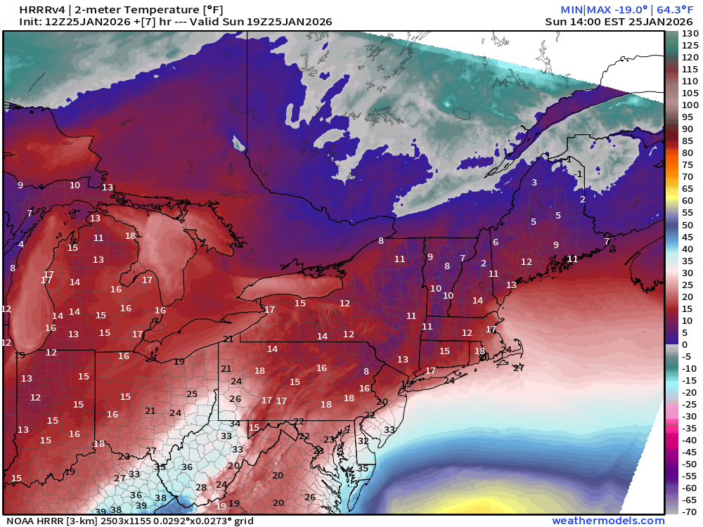
Good morning! Another frigid morning out there with a wide range of temperatures in the single digits above and below zero away from the shore. This is thanks to clear skies and light winds that has allowed for radiational cooling. Here is a sampling of temperatures from across SNE:
Ludlow, MA -14°
Orange, MA -13°
Hatfield, MA -12°
Belchertown, MA -11°
Colebrook, CT -11°
Coventry, RI -8°
Griswold, CT -6°
Manchester, CT -4°
Moodus, CT -3°
Pembroke, MA -1°
I continue to follow two main weather headlines: 1) Bitterly cold temperatures; and 2) Will we will see impacts from a large ocean storm this weekend?
🥶🌡️ Cold: For context, the average high temperatures this time of year across SNE are in the mid to upper 30s, with lows in the upper teens to around 20°. But we won’t get out of the 20s between now and the end of the weekend and on Friday we won’t get out of the teens as a reinforcing shot of Arctic air comes in. Overnight lows will continue to be down near zero away from the shoreline…Friday night…most will drop below zero. Just a brutal stretch of cold, well below average. By early next week…high temps around 30° will feel balmy! But no big warm ups are in site… and I am keeping my eye on another potential polar vortex split, which could keep us cold through a good chunk of February.
1/2


English
@Eweather13 Thank you for summing up all the midday models so I could catch up after work easily 😆
English
Checking back in on the scenarios after the midday model runs:
GFS/GEFS: Scenario B (A for SE coastal areas)
GFS AI: B (A for SE coastal areas)
Euro: C (EPS is closer: B)
Euro AI: B (A for SE MA)
Canadian: B (A for SE coastal areas)
Icon: C
So the majority are in the Scenario B camp but noteworthy is that some of these runs where this storm grazes SNE are very impactful for SE areas (for example A-type impacts east while central and western areas see little to no impact.
Euro and Icon mostly miss on the midday runs…although the Euro ensembles and AI version are farther west and more impactful.
Good news…no straight up scenarios A’s today which would be widespread significant impacts across SNE. But expect changes…these models will likely move back and forth the next couple of days.
Current probabilities: 70% B, 20% C, 10% A

English
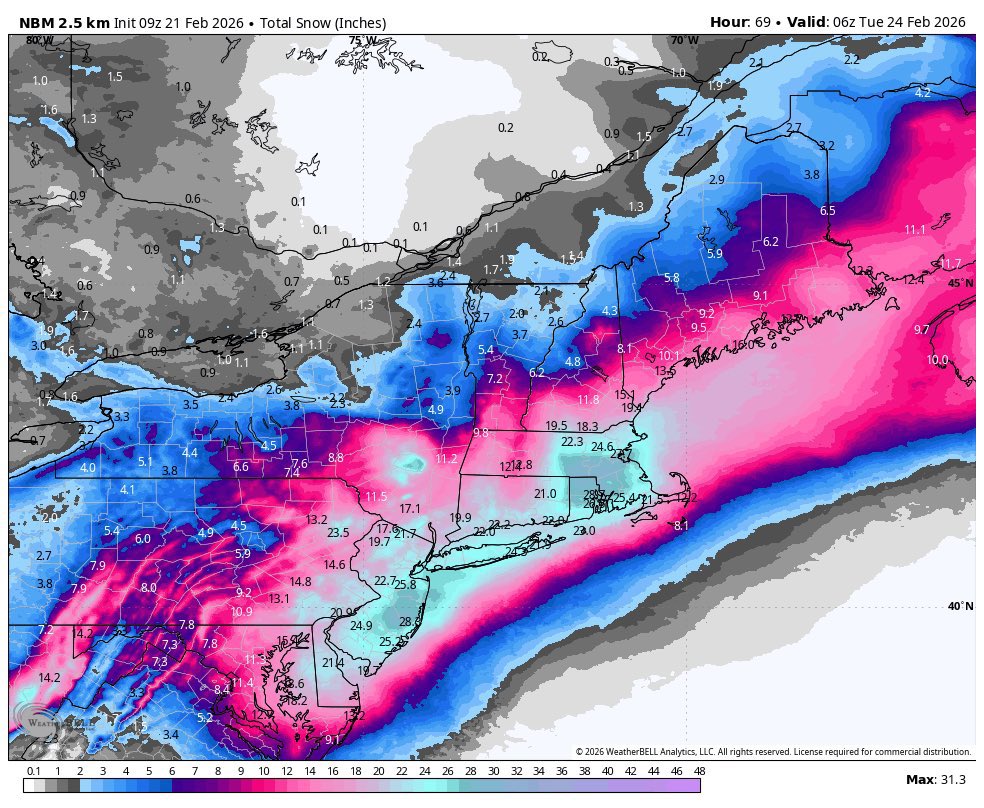
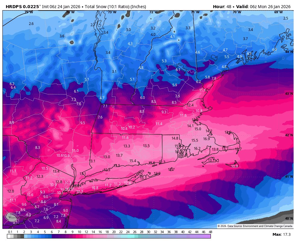
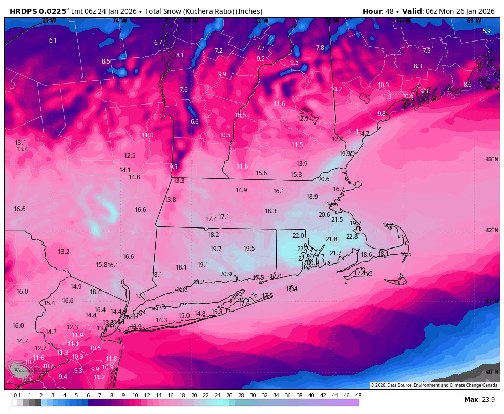
Storm total up to 16” now. Still snowing steadily with beautiful big fat flakes. Temps are in the upper teens. Literal snow-globe energy outside right now. ✨☃️
#VTwx
English
@RyanMaue While BTV technically had blizzard conditions just a couple years ago the eastern part of VT and northern NH haven’t had blizzard conditions since 2007…. Wild that it’s been that long. This storm won’t change that either.
English

We've been waiting years for a major winter storm like Fern to come along and shatter the Northeast's "snow miser" drought, and all done with 999 mb low pressure, onshore flow, and extreme Arctic cold -- not expecting that at all 10-days ago.
Still waiting on a true blizzard.
English
Y’all acting like it’s over up here or never materialized… this was never a quick big dump but a long pile up.
CT Weather@Connecticut_WX
How does another 20 hours of snow sound?
English
Measuring 7” of the driest snow ever as of 8pm. This snow is the consistency of sand — no snowmen to be found. ☃️
Hartland #Vermont
@NWSBurlington #VTwx
English
Storm update - snow is beginning in Hartland Vermont. The dry air didn’t inhibit the snow development at the front end of the system very much. 1° air temperature currently.
English
@Eweather13 Which inland is your gut talking about? CT? VT/NH? lol. How far inland does your gut go?
English
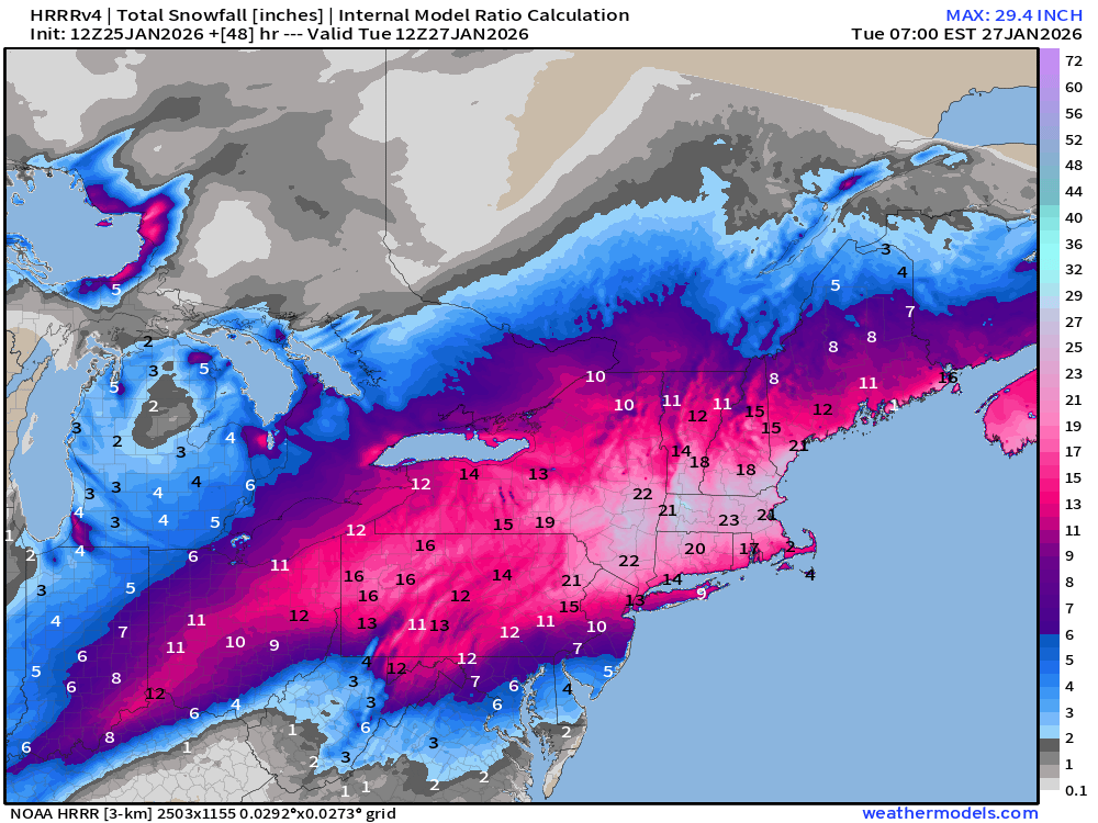
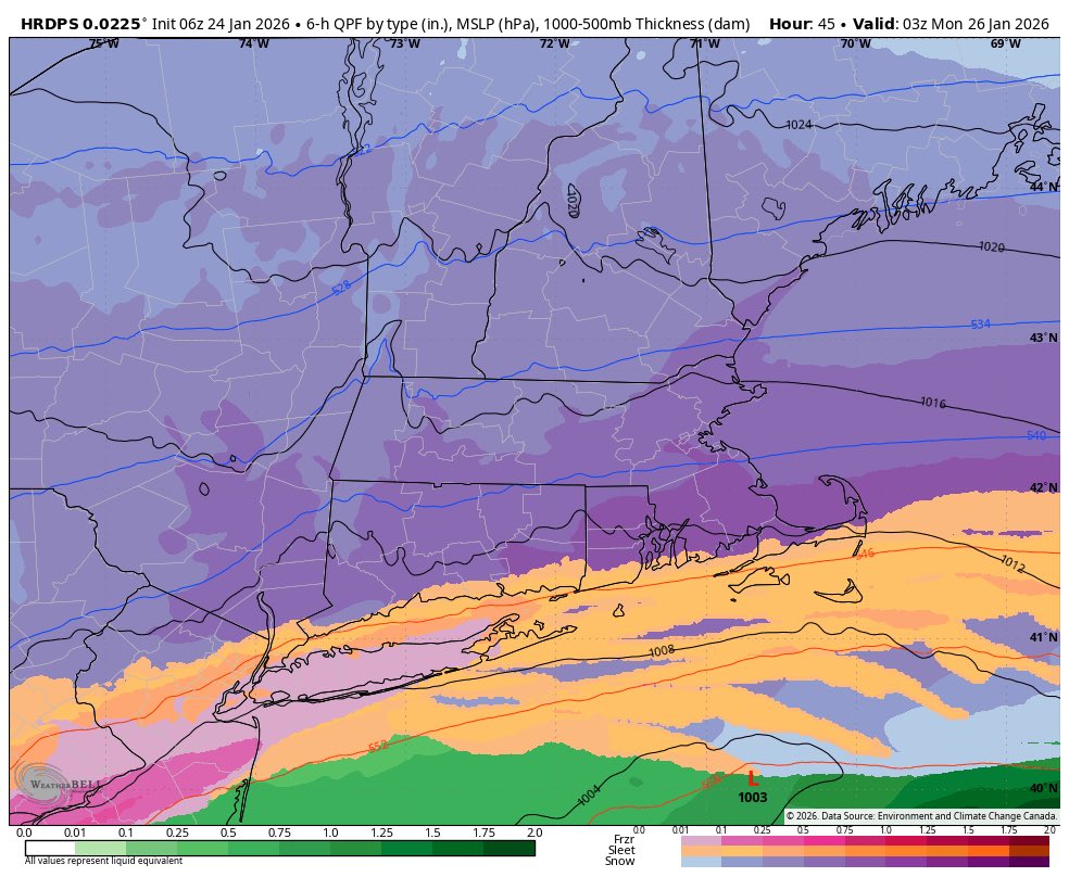
@DHTheWeatherNut This is a really impressive amount of dry air getting wrapping into the storm and wringing it out for Monday
English
We are going to totally rock, just you wait... in all seriousness, this will move through WMass/CMass, or maybe stays just south into CT, but it will lower snow rates after midnight at some point, shutting off lift into the DGZ... periods of lighter snow through Monday

English
@Eweather13 Total QPF is definitely less (especially to the north) as the short range models come into time for the whole event. The dry air and lack of phasing is really impacting this storm. So close to being epic. But it’s still a solid system.
English
@ContentWxGuy This set up has been so much fun to follow all week long. It’s one of my favorite things about winter. Hope we get to do it again all next week!
English
Incredible. Look at the Arctic spilling southward through Western Canada.
Three short waves racing to interact.
We still may not quite have the full grasp on what this will become yet this visual process unfolding is rather exciting to be honest. A rare one to follow.
GIF
English

@NEwinter_WX I’m on the northwest edge of your 18+ in VT. I’ll let you know. Lol.
FWIW I think we will easily 15-24”. 18+ is not a long shot at all
English

Here’s my map I will be wrong I’m sure but best guess
Inside black is where I think 18+ could happen

English