Angelic Panda Meteorology
10K posts

Angelic Panda Meteorology
@APGMeteorology
@AngelPandaEarth's weather account; tracks tropical cyclones worldwide. ⚠️ IMPORTANT: I'M NOT AN ACTUAL METEOROLOGIST AND ALL OF MY PRODUCTS ARE UNOFFICIAL.
Virginia, USA Katılım Mayıs 2022
34 Takip Edilen536 Takipçiler

#APMetTWO 26D107
Global #TropicalWeather Outlook
April 17, 2026 @ 2:20 AM UTC
==
[C1] #SINLAKU: 90 mph, 150 kph / 963 mbar
A steadily weakening #typhoon finally starting to depart the #Marianas. It doesn’t have too much time left as a tropical cyclone.


English

#APMetTWO 26D106
Global #TropicalWeather Outlook
April 16, 2026 @ 3:00 AM UTC
==
[C3] #SINLAKU: 120 mph, 195 kph / 932 mbar
It’s still a very strong #typhoon affecting portions of the #Marianas as it turns toward the northeast.


English

#APMetTWO 26D105
Global #TropicalWeather Outlook
April 15, 2026 @ 2:20 AM UTC
==
[C3] #SINLAKU: 125 mph, 205 kph / 924 mbar
Passing by and through the #Marianas as a formidable #typhoon. Intense winds and rainfall are expected to continue across the islands.


English

[#SINLAKU cont.]
Intense winds and rainfall are expected across the islands starting later today.
==
The next outlook is expected 2:30 - 4:30 AM UTC tomorrow.
Angelic Panda Meteorology
English

#APMetTWO 26D104
Global #TropicalWeather Outlook
April 14, 2026 @ 1:50 AM UTC
==
[C4] #SINLAKU: 155 mph, 250 kph / 912 mbar
While it’s no longer at Category 5 strength (after 42 hours), it’s still a very powerful #typhoon expected to pass through the #Marianas. [...]


English

26D103**
For April 13, 2026*****
Angelic Panda Meteorology@APGMeteorology
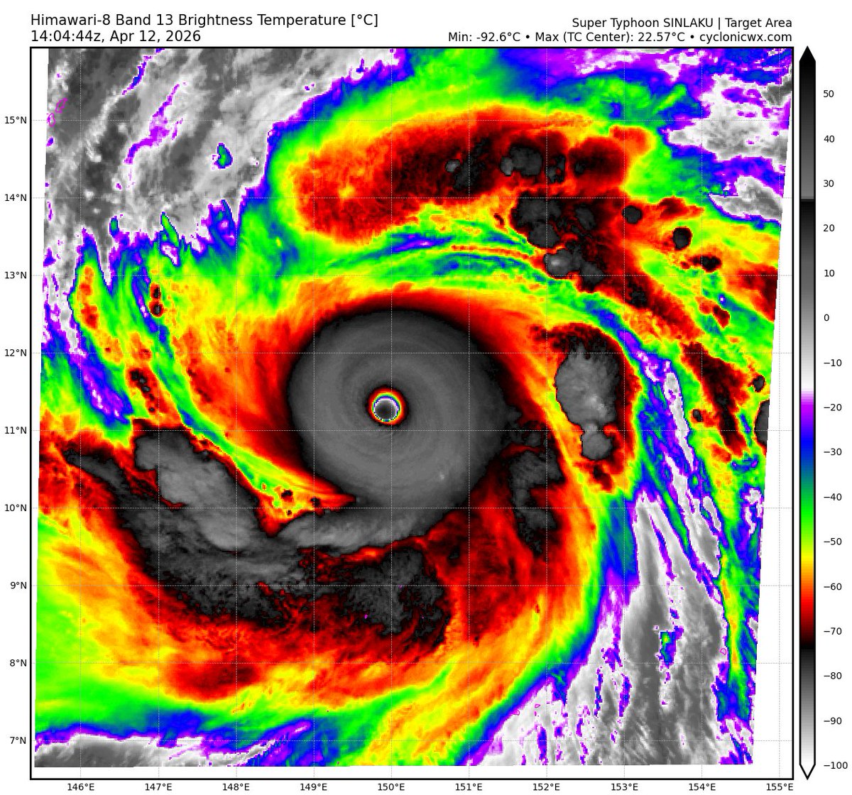
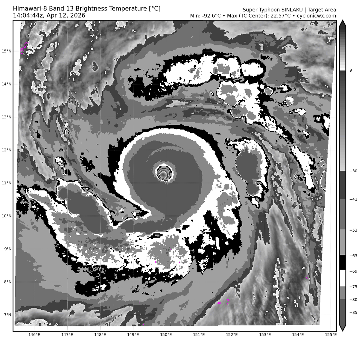
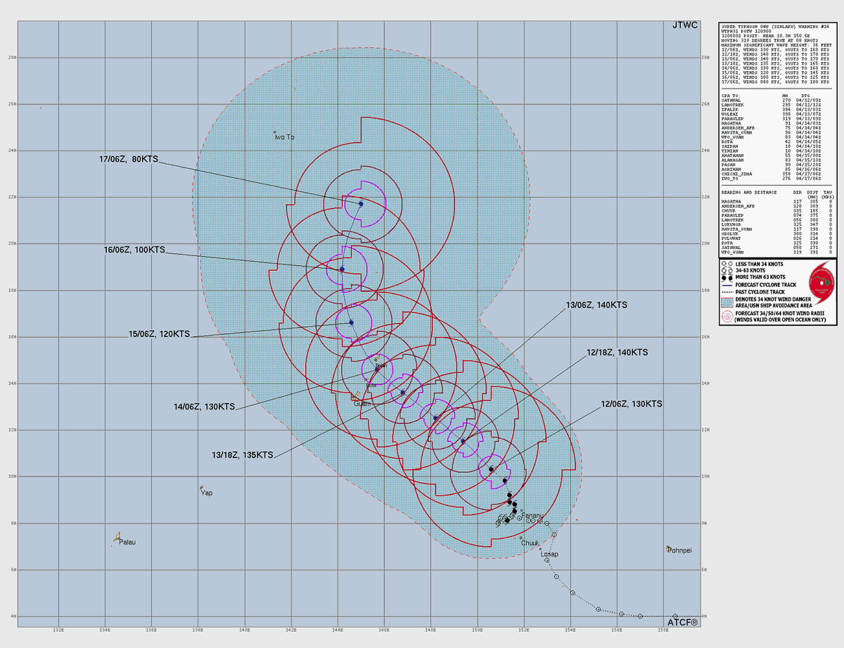
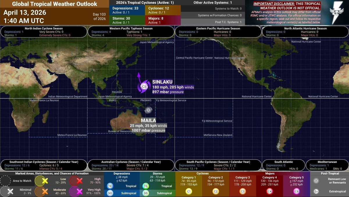
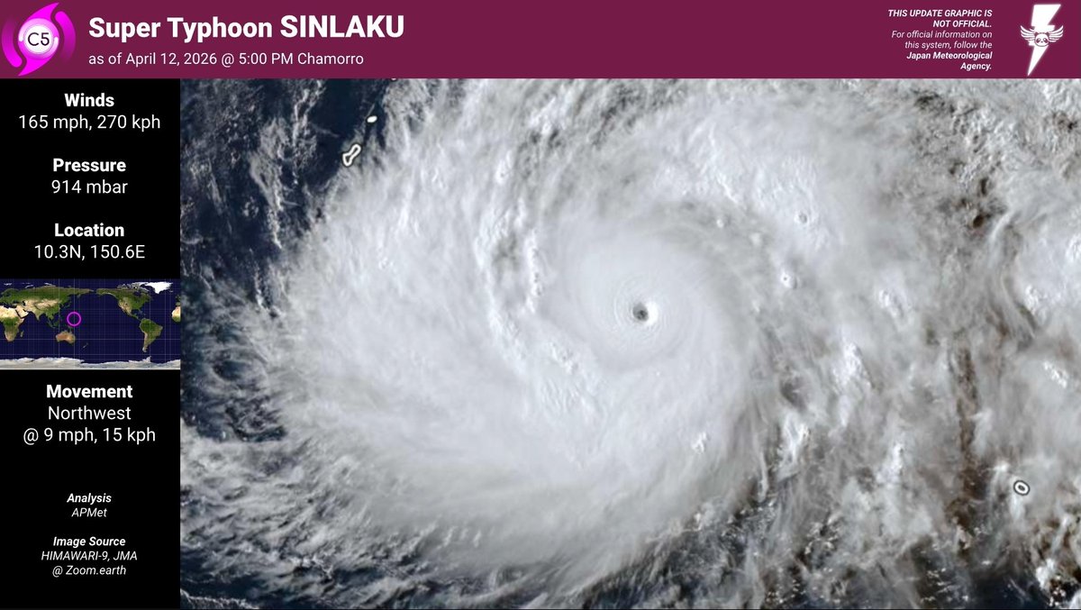
#APMetTWO 26D102 Global #TropicalWeather Outlook April 12, 2026 @ 1:50 AM UTC == [C5] #SINLAKU: 180 mph, 285 kph / 897 mbar Slightly weakened its peak a little while ago, but remains a violent #typhoon. Preparations in #Guam and the #Marianas should be quickly completed [...]
Español
Angelic Panda Meteorology retweetledi

Typhoon #Sinlaku has rapidly intensified into a menacing Category 5 typhoon. The extremely stable eye is surrounded by -80 C convection which is normally seen in high echelon typhoons with winds of 165+ kts. Currently, the official intensity from the JTWC is 150 kt and a pressure of 902 mb but the storm is likely stronger then this. At this point, some more strengthening is possible over the next day but that is highly dependent on whether an eyewall replacement cycle (EWRC) occurs or not. At this point, there are no indictions of an EWRC but they can be quite hard to predict. Sinlaku is expected to strike the Northern Mariana Islands in under 48 hours as an extremely strong typhoon so all residents on the islands need to prepare for impact. A landfall is possible for the Northern Mariana Islands bit is possible the storm makes a close pass with no landfall. Regardless, impacts will be extreme either way.


English
Angelic Panda Meteorology retweetledi

[TS] #VAIANU: 60 mph, 95 kph / 976 mbar
It managed to make landfall on #NewZealand’s #NorthIsland as a tropical cyclone, although it’s borderline extratropical.
[RL] #MAILA: 30 mph, 45 kph / 1000 mbar
Lingering over eastern #PapuaNewGuinea.
English

[RL] #MAILA: 45 mph, 75 kph / 995 mbar
It has quickly degenerated into a remnant low. Some rain may still be present in portions of eastern #PapuaNewGuinea.
==
The next outlook is expected 2:30 - 4:30 AM UTC tomorrow.
Angelic Panda Meteorology
English

[C1] #VAIANU: 75 mph, 120 kph / 974 mbar
Yes, somehow it’s still primarily tropical. Set to impact #NewZealand this weekend and preparations should be rushed to completion.
English


