Sabitlenmiş Tweet

Anthony Duarte
50.5K posts
@AnthonyDuarte03
Associate Weather Producer/Meteorologist @Univision • PhD student studying TCs @FIU • Skywarn Storm Spotter • @CoCoRaHS Volunteer • IG Wx Account: @ sfwa_mia
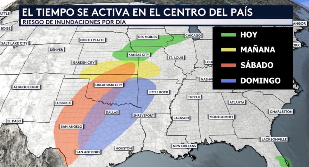
Today marks the first of what will be several more days of severe weather that we are forecasting across the central United States. The Storm Prediction Center has highlighted six specific areas where we should expect severe weather every single day between today all the way through next Tuesday. Hoy será el comienzo de varios días más de tiempo severo que estaremos pronosticando sobre el centro de Estados Unidos. El Centro de Predicción de Tormentas ha destacado seis áreas específicas en las que debemos esperar tiempo severo cada uno de los días desde hoy y hasta el próximo martes inclusive.
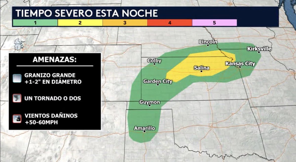
We are anticipating a risk of severe weather today across the central part of the country, including the states of Texas, Oklahoma, Colorado, Kansas, Missouri, Nebraska, and Iowa. A stationary front will he draped across the Central Plains, where storm initiation is currently expected to occur between 22Z and 00Z tonight. Initially, these storms will be capable of producing all severe hazards, including large hail (1–2+ inches in diameter), a tornado or two, and strong to damaging wind gusts (50–60+ mph). The area shaded in yellow, representing a Level 2 out of 5 on our risk assessment scale, is where we have the highest probability of seeing this large hail. After midnight, our model consensus indicates that the ongoing storms across northeastern Kansas will merge to form a large cluster, which is expected to move slowly thereafter toward northwestern Missouri and the Kansas City metropolitan area, posing a risk primarily of damaging winds. Hoy estamos esperando el riesgo de tiempo severo sobre la parte central de la país incluyendo los estados de Texas, Oklahoma, Colorado, Kansas, Missouri, Nebraska y Iowa. Habrá un límite estacionario extendido sobre las planicies centrales, donde actualmente se espera que el inicie de tormenta ocurra entre las 22Z y las 00Z de esta noche. Inicialmente, las tormentas serán capaces de generar todos los fenómenos severos, incluyendo granizo de gran tamaño (+1-2 pulgadas de diámetro), uno o dos tornados, y ráfagas de viento de fuertes a dañinas (+50-60 mph). La zona sombreada con el color amarillo, representando un nivel 2 de 5 en nuestra escala de evaluación de riesgo, es donde tendremos la mejor probabilidad de ver ese granizo grande. Después de la medianoche el consenso de nuestro modelo indica que las tormentas en curso a través del noreste de Kansas se fusionarán y formarán un gran cúmulo, el cual se espera que se desplace lentamente hacia el noroeste de Missouri y el área metropolitana de Kansas City, suponiendo un riesgo principalmente de viento dañino.
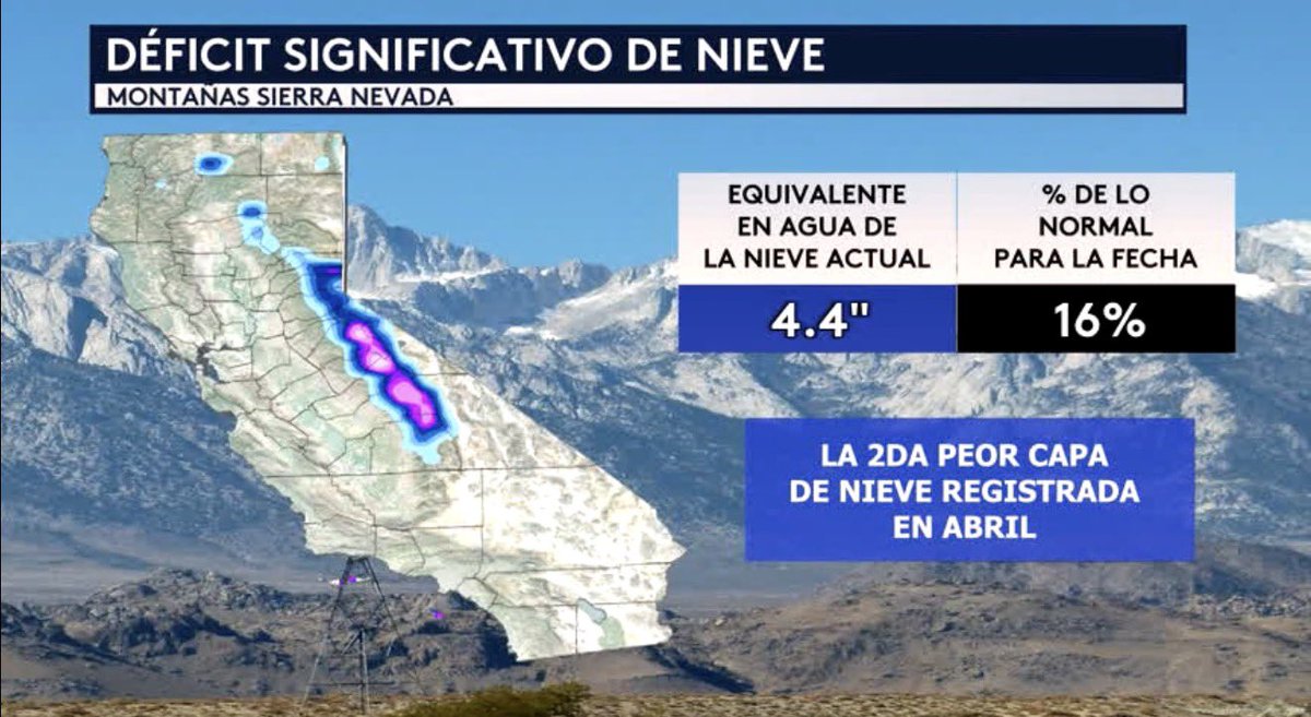
We have a significant snow deficit in California's Sierra Nevada Mountains. Our current snow-water equivalent stands at 4.4 inches, representing only 16% of normal for this time of year. In fact, when state officials conducted their annual survey of the Sierra Nevada snowpack last Wednesday, April 1, they determined it was the second-worst snowpack on record at the time of this assessment, trailing only that of 2015. These numbers are extremely concerning, given that the Sierra Nevada snowpack typically provides roughly 30% of California's annual water supply. Tenemos un déficit significativo de nieve en las Montañas Sierra Nevada de California. El equivalente en agua de la nieve actual es de 4.4 pulgadas, lo que representa solo un 16% de lo normal para la fecha. De hecho, cuando los oficiales estatales llevaron a cabo el estudio anual de la capa de nieve de Sierra Nevada el pasado miércoles 1 de abril, determinaron que se trata de la segunda peor capa de nieve registrada, superada únicamente por la de 2015. Estos números son bien preocupantes, dado que la capa de nieve de Sierra Nevada suele aportar aproximadamente el 30 % del suministro de agua de California anualmente.
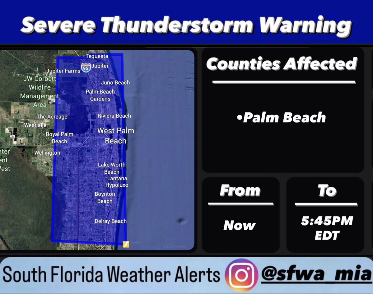
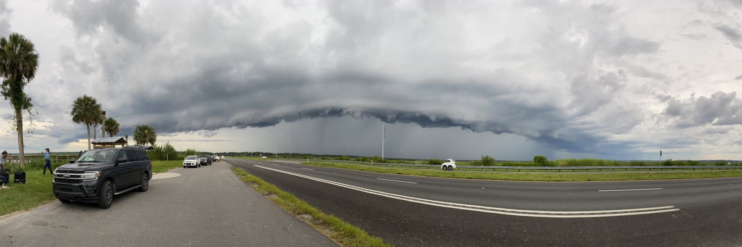
Today will be another unstable day across the Sunshine State due to the lingering presence of a plume of tropical moisture associated with a frontal boundary currently stalled just south of the peninsula. Rain remains in the forecast for tomorrow, though we expect the intensity of these showers to be lower and their coverage less widespread. By Saturday, high pressure will begin to build and drier ambient air will move into the peninsula, paving the way for drier conditions. We will likely only have to contend with a few isolated showers moving in from the Atlantic. Hoy será otro día inestable a través del estado del sol debido a la presencia persistence de una columna de humedad tropical asociada con un límite frontal que se mantiene estacionado al sur de la península. Para mañana, todavía tendremos lluvia en el pronóstico, aunque esperamos que la intensidad de estos aguaceros ya no sea tan alta ni que su cobertura sea tan generalizada. A partir del sábado, alta presión estará desarrollándose y aire ambiental más seco estará moviéndose hacia la península, dándole paso a condiciones más secas. Solo estaremos lidiando con quizás algunos aguaceros aislados avanzando desde el Atlántico.
Take a look at this video from yesterday showing the adverse conditions that were being observed in Daytona Beach, Florida. With strong winds churning up the surf and intermittent showers, it was undoubtedly not the most ideal day to be near the ocean. Les echamos un vistazo a este vídeo que fue tomado ayer de las condiciones adversas que se estaban observando en Daytona Beach, Florida. Con fuertes vientos que agitaban el oleaje y chubascos intermitentes, sin duda, no era el día más ideal para estar cerca del océano.