Charlie Lopresti

20.6K posts

Charlie Lopresti banner
Charlie Lopresti

Charlie Lopresti

@CharlieWGME

Chief Meteorologist at WGME CBS 13 & WPFO FOX23 in Portland Maine. Loves skiing, dogs, and giant pumpkins. https://t.co/ErguamVZP0

Portland Maine Katılım Nisan 2012
455 Takip Edilen7.7K Takipçiler
Charlie Lopresti
Charlie Lopresti@CharlieWGME·
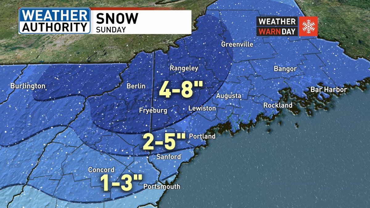
Rain with tonight's cold front will be ending before daybreak Friday. A chilly airmass will settle in through the first half of the weekend. Temps will be in the upper 30s to around 40 Friday. Highs will struggle to get above freezing Saturday.
GIF
English
0
1
5
375
Charlie Lopresti
Charlie Lopresti@CharlieWGME·
Thursday will be the warmest day of the stretch. After a gray start, the sun should poke out sending temps into the 50s and low 60s. The exception will be Midcoast Maine where a wind off the ocean will provide cooler conditions.
English
1
0
2
595
Charlie Lopresti
Charlie Lopresti@CharlieWGME·
Out like a lamb but with big temperature swings.
Charlie Lopresti tweet media
English
0
0
2
394
Charlie Lopresti
Charlie Lopresti@CharlieWGME·
Hermit Lake Shelter on the east side of Mount Washington is reporting nearly a foot of new snow over the past four days. Buddy and I went up to check it out.
Charlie Lopresti tweet media
English
0
2
31
601
Charlie Lopresti
Charlie Lopresti@CharlieWGME·
More light snow is expected tonight. Combo of upper air disturbance and inverted surface trough will bring more snow to the area. A coating is possible for southern and central Maine. A few spots in the White Mountains could pick up another half foot.
GIF
English
0
0
1
477
Charlie Lopresti
Charlie Lopresti@CharlieWGME·
Looking ahead to Monday we have a few things to watch. 1, low pressure tracking south may bring snow to southern NH and York County for the AM commute. 2, inverted trough should bring snow to parts of NH and Western Maine Monday night. For the rest of us, expect snow showers.
English
0
1
2
1.2K
Charlie Lopresti
Charlie Lopresti@CharlieWGME·
Here's an estimate in precip type and timing today. A change to sleet and rain will hold totals down for southern areas.
English
1
0
2
965
Charlie Lopresti
Charlie Lopresti@CharlieWGME·
Good morning. Today's snowfall totals should range from a coating south to over a half foot in the mountains. A change to sleet and rain is likely for southern parts of the region. Take it slow this morning.
Charlie Lopresti tweet media
English
1
0
7
958
Charlie Lopresti retweetledi
Ryan Munn
Ryan Munn@RyanWGME·
SUNDAY'S SNOW MAP UPDATE: The snow totals are going up across the state. Snow starts between 4-9 AM Sunday and continues throughout the day. Some mixing likely in southern York County, potentially up through the Portland region. All snow expected inland. (1/2)
Ryan Munn tweet media
English
1
1
3
741
Charlie Lopresti
Charlie Lopresti@CharlieWGME·
JUST IN: A Winter Storm Warning has been issued for portions of our area until 3/23 2:00AM. Head to wgme.com for the latest updates. @WGME
Charlie Lopresti tweet media
English
0
1
2
2.3K
Charlie Lopresti
Charlie Lopresti@CharlieWGME·
The parade of weak systems continues. The Sunday-Monday system is probably the one to watch in the coming days. Enjoy a little bit of sun Friday morning.
English
0
1
3
558
Charlie Lopresti
Charlie Lopresti@CharlieWGME·
That narrow band of snow was a good time. A forecast for snow showers quickly turned into 3" to 5" for Topsham and Brunswick.
GIF
English
0
1
3
463
Charlie Lopresti retweetledi
Emily Santom
Emily Santom@EmilyWGME·
Ocean-effect snow has been impacting Midcoast Maine for the past several hours now. Road conditions are difficult in that area with several crashes being reported by Maine State Police. Take your time in this area!
English
0
1
3
247
Charlie Lopresti
Charlie Lopresti@CharlieWGME·
No big storms are in the forecast, but we're tracking a bunch of weak systems through the weekend.
English
0
0
1
358
Charlie Lopresti
Charlie Lopresti@CharlieWGME·
No more green on St. Patrick's Day? The rain will be exiting during the early morning Tuesday. Heaviest rainfall will be 8PM to 4AM. Our strongest southerly winds with gusts over 40 MPH will be 11PM through 5AM. Frequent westerly gusts 30 to 40 MPH are expected Tuesday.
English
0
1
2
975
Charlie Lopresti retweetledi
Ryan Munn
Ryan Munn@RyanWGME·
Snow is expected to develop Friday evening and night. This will continue at times into early Saturday morning. Some mixing possible in coastal York and Cumberland Counties. The highest elevations are expected to see the highest totals.
Ryan Munn tweet media
English
0
1
4
376
Charlie Lopresti
Charlie Lopresti@CharlieWGME·
The active pattern continues with lots of ups and downs in the coming days. Yesterday's 60s and 70s unfortunately will not be returning anytime soon.
English
1
0
2
506
Charlie Lopresti
Charlie Lopresti@CharlieWGME·
It's back to March today! Augusta Regional Airport had a 24 drop from 72° to 37°. That's the 6th biggest March drop on record there. Lewiston Auburn Regional Airport had a 24 hr drop from 71° to 37° which is the 8th biggest March drop on record.
Charlie Lopresti tweet mediaCharlie Lopresti tweet media
English
0
0
3
381
Charlie Lopresti
Charlie Lopresti@CharlieWGME·
Lots of changes on the trails in a week. Wet feet and wet dog season has returned.
English
0
0
5
271
Charlie Lopresti
Charlie Lopresti@CharlieWGME·
Temp has been warmer only three times this early in the season over the past 85 years at the Portland Jetport. It's back to March tomorrow!
Charlie Lopresti tweet media
English
0
0
2
438