Chase Bryant

4.5K posts

Chase Bryant banner
Chase Bryant

Chase Bryant

@ChaseBWeather

Jasper, TN native. MCHS 2020. Vol State 2025. Soon-to-be Mississippi State meteorology student. Forecaster for the Tri-State Area Weather (TN/AL/GA) group.

Tennessee, USA Katılım Şubat 2019
1.7K Takip Edilen483 Takipçiler
Chase Bryant retweetledi
BobbyBoyd1946 ⛪️
BobbyBoyd1946 ⛪️@bobby_boyd1946·
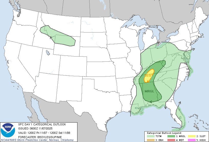
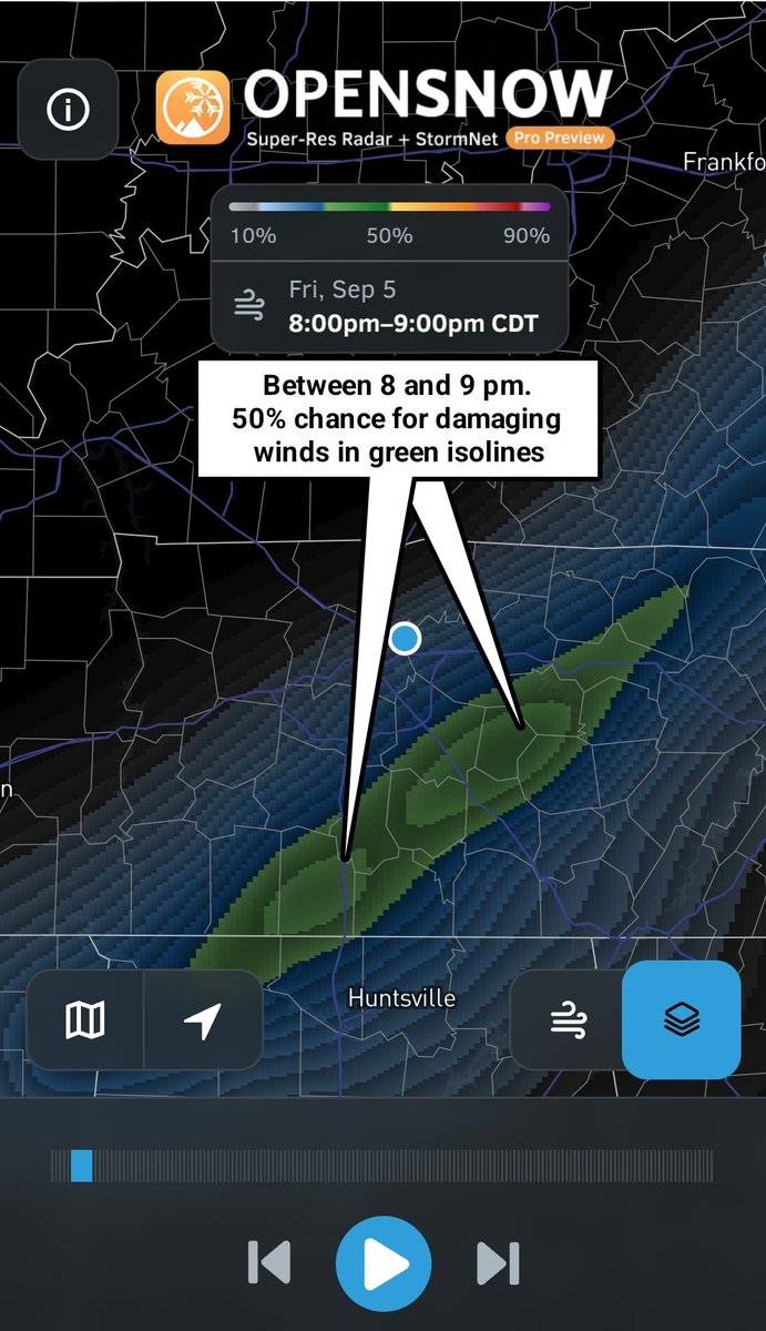
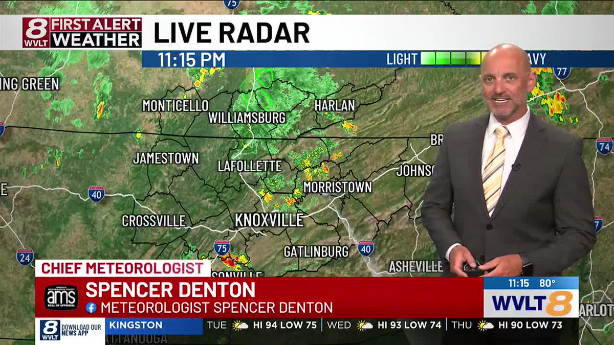
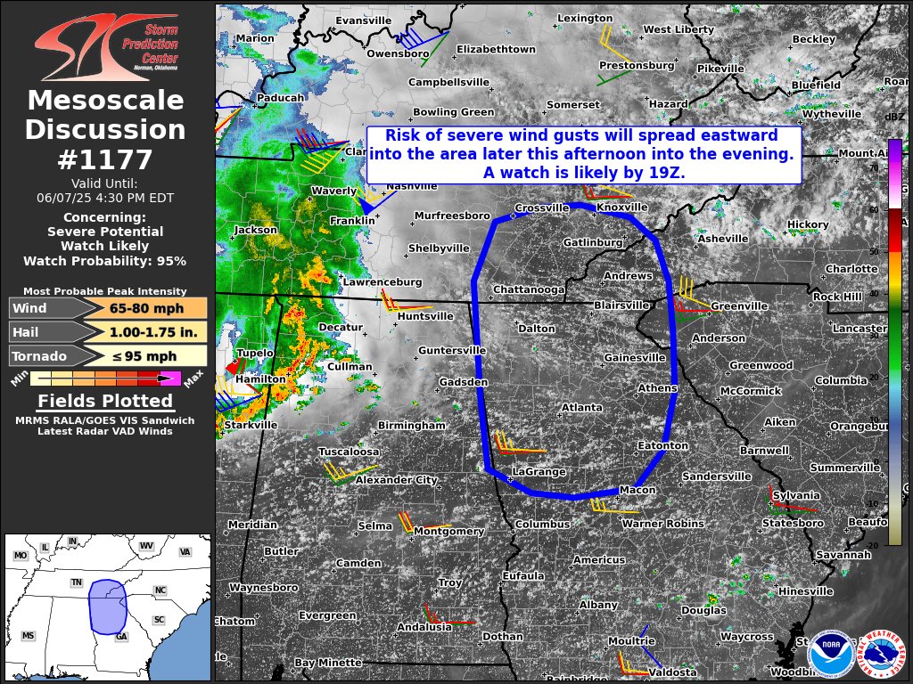
Latest Stormnet-AI continues the trend of wide swath of damaging winds with embedded spin ups. This looks to be more of a QLCS type event for Middle Tennessee and southern Kentucky. Wind damage could be widespread. My Tempest has start time for the stronger storms in Nashville around 9 pm with storms overnight by 1 or 2 am followed shortly by FROPA.
BobbyBoyd1946 ⛪️ tweet mediaBobbyBoyd1946 ⛪️ tweet mediaBobbyBoyd1946 ⛪️ tweet mediaBobbyBoyd1946 ⛪️ tweet media
English
0
5
46
4.2K
Chase Bryant retweetledi
BobbyBoyd1946 ⛪️
BobbyBoyd1946 ⛪️@bobby_boyd1946·
Potential for storms to produce damaging winds on Wednesday in Middle Tennessee and southern Kentucky. #TNwx #KYwx
BobbyBoyd1946 ⛪️ tweet mediaBobbyBoyd1946 ⛪️ tweet media
English
0
8
46
2.6K
Chase Bryant
Chase Bryant@ChaseBWeather·
Going to have to say I am surprised to see this good of agreement on a mid-late October cold snap that is some 2 weeks out in time. Let's see if the trend holds true... #tnwx #gawx #alwx
Chase Bryant tweet mediaChase Bryant tweet media
English
0
0
0
80
𝙎𝙥𝙚𝙣𝙘𝙚𝙧 𝘿𝙚𝙣𝙩𝙤𝙣
I told @RonChilders when I moved to Memphis 11 years ago that I could go the rest of my career not being "Chief" if I was able to work alongside a great weather team (and get paid enough to do it lol). I came to Knoxville with the same mindset. I guess God had other plans.
𝙎𝙥𝙚𝙣𝙘𝙚𝙧 𝘿𝙚𝙣𝙩𝙤𝙣 tweet media
English
38
6
177
8.5K
Chase Bryant retweetledi
NWS Morristown
NWS Morristown@NWSMorristown·
Temperatures will continue to increase into early next week with Wednesday possibly being the hottest day of this heat wave. For much of the Valley, there is generally a 40% to 70% chance of actual temperatures reaching 100°F with heat index values approaching 105°F for some.
NWS Morristown tweet media
English
1
8
37
2.3K
Chase Bryant retweetledi
NWS Severe Tstorm
NWS Severe Tstorm@NWSSevereTstorm·
A severe thunderstorm watch has been issued for parts of Alabama and Tennessee until 10 PM CDT
NWS Severe Tstorm tweet media
English
0
36
48
3.7K
Chase Bryant retweetledi
NWS Storm Prediction Center
12:41am CDT #SPC Day1 Outlook Enhanced Risk: today into this evening across parts of cntrl/ern KY middle and ern TN nwrn GA nrn AL nrn and cntrl MS sern AR nrn and cntrl LA cntrl and ern TX spc.noaa.gov/products/outlo…
NWS Storm Prediction Center tweet media
English
27
183
789
63.6K
Chase Bryant retweetledi
NWS Storm Prediction Center
It looks like the severe risk is going to increase on Monday/April 28th and Tuesday/April 29th from the Great Plains eastward into the mid to upper Mississippi Valley and Great Lakes. All hazards will be possible.
NWS Storm Prediction Center tweet media
English
10
130
461
100.1K