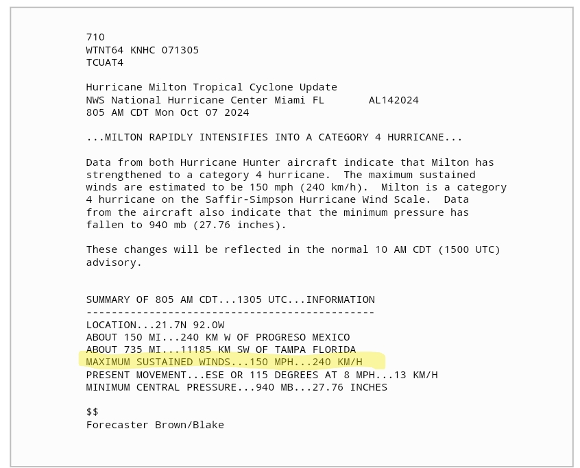
Ryan Mieras

1.1K posts

Ryan Mieras banner
Ryan Mieras

Ryan Mieras

@CoastalProf

Asst. Professor | Coastal Engineering | UNCW Fanatic of Hurricanes, MATLAB, Rubik's cubes, Dogfish Head beer, Texas BBQ, and a good label maker. GO SPURS GO

Katılım Aralık 2019
99 Takip Edilen813 Takipçiler
Sabitlenmiş Tweet
Ryan Mieras
Ryan Mieras@CoastalProf·
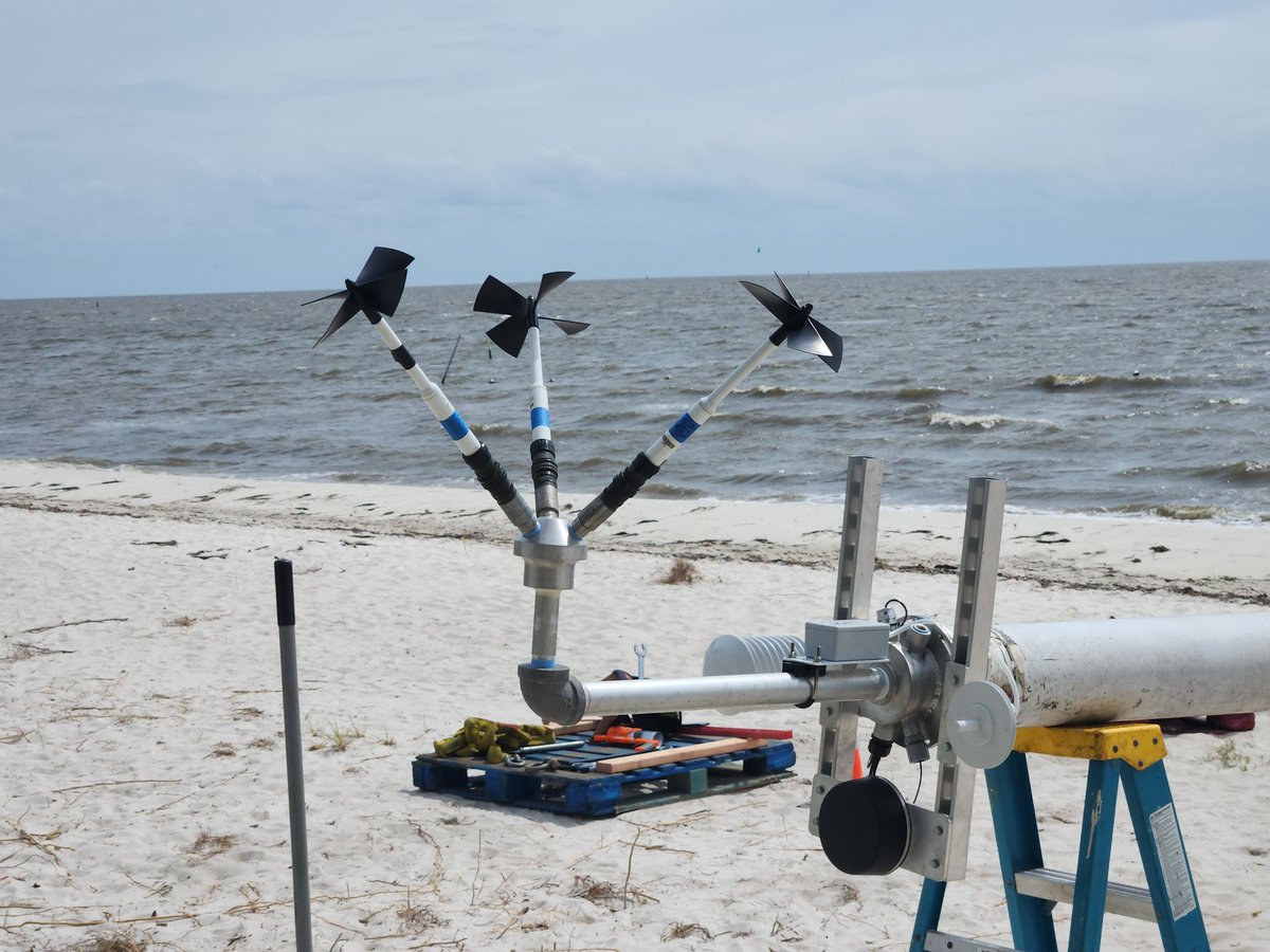
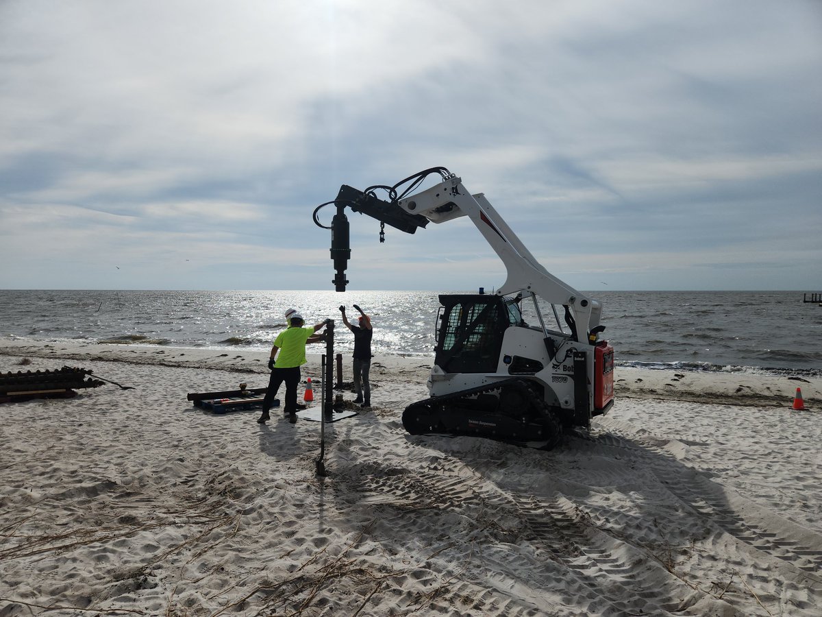
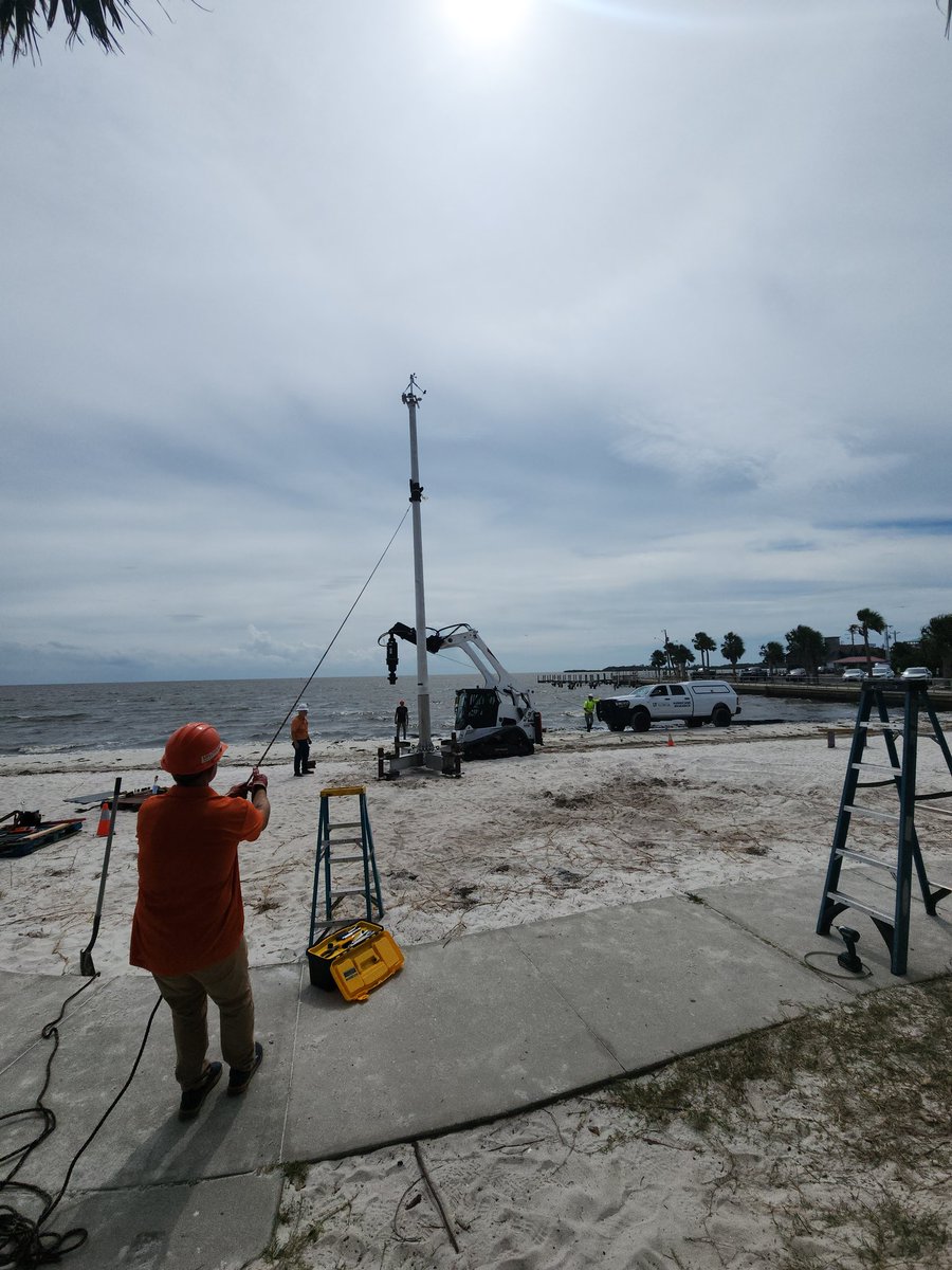
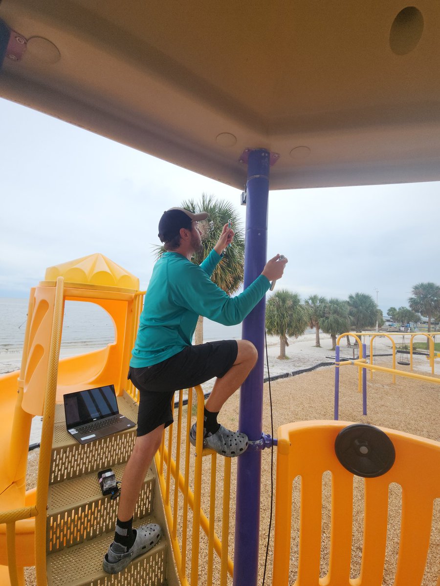
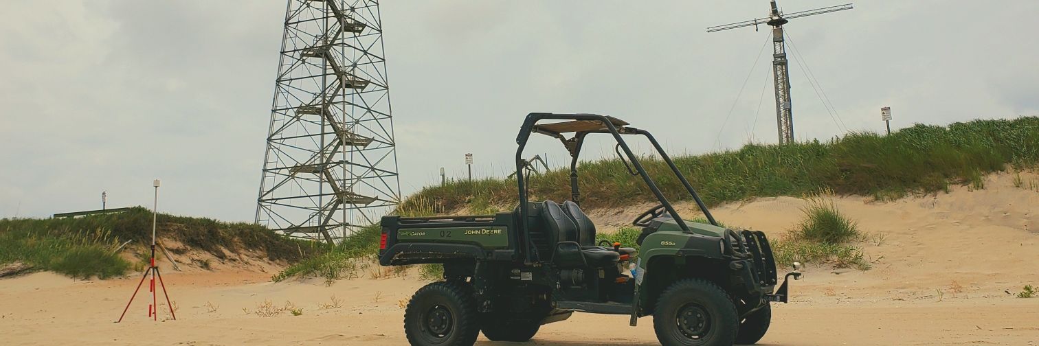
🚨 Latest pub is out related to the REALDUNE/REFLEX experiment! These are the most highly-resolved field measurements of active dune face erosion DURING storm impact, that I am aware of. agupubs.onlinelibrary.wiley.com/doi/10.1029/20… Credit to whole REALDUNE/REFLEX team and collaborators!
English
0
0
5
296
Ryan Mieras
Ryan Mieras@CoastalProf·
🚨SHARE WIDELY🚨 The abstract submission deadline has been EXTENDED for YCSECA 2025, the best conference for young coastal scientists and engineers!!! It will be held in the beautiful coastal city of Wilmington, NC this summer. ycseca.wordpress.com/2025/04/21/ycs…
English
0
4
6
308
Ryan Mieras
Ryan Mieras@CoastalProf·
SEEKING Ph.D. STUDENT ASAP!!! Full details in image 🙌 Project summary here: coastalreview.org/2024/01/uncw-r… Deadline to apply for priority consideration is Febraury 15, 2025. Reach out to email listed in image for more info.
Ryan Mieras tweet media
English
0
2
2
314
Ryan Mieras
Ryan Mieras@CoastalProf·
@elonmusk how do I turn off all push notifications from you? I never signed up for that. Thank you.
English
1
0
0
67
Ryan Mieras
Ryan Mieras@CoastalProf·
CAN YOU FIND DOUG, from Liberty Mutual?! In the annual Halloween party/lecture in Fluid Mechanics at UNCW
Ryan Mieras tweet mediaRyan Mieras tweet media
English
0
0
0
173
Ryan Mieras retweetledi
Katherine Anarde
Katherine Anarde@anardeeek·
I am advertising a two-year postdoc related to remote sensing of chronic coastal floods. The position will be jointly at UNC Chapel Hill in the Global Hydrology Lab and in my research group, the Coastal Hazards Lab at North Carolina State University: lnkd.in/eWaX8W7m
Katherine Anarde tweet media
English
0
13
32
2.7K
Ryan Mieras
Ryan Mieras@CoastalProf·
Somebody tell me I'm wrong.... #HurricaneMilton (left) is the Evil twin of 2016 Hurricane Matthew (right)... 🤷
Ryan Mieras tweet media
English
0
0
5
908
Ryan Mieras
Ryan Mieras@CoastalProf·
CORRECTION: at 905 am EDT, an update was issued, bumping max sustained winds from 125 mph to 150 mph! Meaning, a 25 hr increase of... wait for it... 90 mph! ALMOST 3x THE RAPID INTENSIFICATION REQUIREMENT! #HurricaneMilton 😳😳😳
Ryan Mieras tweet media
Ryan Mieras@CoastalProf

#HurricaneMilton went from a 'measly' 991 mbar and 60 mph, to 945 mbar and 125 mph, in just 24 hrs--an increase of +65 mph! 😳😳😳 That's nearly double the requirement for "rapid intensification," which is +35 mph in 24 hrs.

English
1
0
0
302
Ryan Mieras
Ryan Mieras@CoastalProf·
CORRECTION: at 905 am EDT, an update was issued, bumping max sustained winds from 125 mph to 150 mph! Meaning, a 25 hr increase of... wait for it... 90 mph! ALMOST 3x THE RAPID INTENSIFICATION REQUIREMENT! #HurricaneMilton 😳😳😳
Ryan Mieras tweet media
English
0
0
0
125
Ryan Mieras
Ryan Mieras@CoastalProf·
#HurricaneMilton went from a 'measly' 991 mbar and 60 mph, to 945 mbar and 125 mph, in just 24 hrs--an increase of +65 mph! 😳😳😳 That's nearly double the requirement for "rapid intensification," which is +35 mph in 24 hrs.
English
1
1
5
771
Ryan Mieras
Ryan Mieras@CoastalProf·
When 2 students from your Fluid Mechanics class are boarding a plane and send you pics of the plane's Pitot tubes, one day after your lecture on the Bernoulli equation, stagnation points, and Pitot tubes! 😇 Celebrate the small teaching wins the most! 🥳
Ryan Mieras tweet mediaRyan Mieras tweet media
English
0
0
8
191
Ryan Mieras
Ryan Mieras@CoastalProf·
@hurricanetrack Hurricanes like Matthew in NC (and MANY Others, even "only tropical storms") are MOST memorable for their inland flooding. Remeber the FOUR impacts from tropical systems, and then act #SWIFT Surge Wind Inland Flooding Tornados
English
0
0
0
56
Ryan Mieras
Ryan Mieras@CoastalProf·
@hurricanetrack Excellent points Mark! Keep in mind for Florida, a LARGE portion of the west/nature coast experienced RECORD surge on record. Category also doesn't account for "size" Texans all remember Ike in '08, which had 20+ ft of surge but was "only" a Cat 2 landfall
English
1
0
5
241
Mark Sudduth
Mark Sudduth@hurricanetrack·
Florida is bad. Western NC is truly catastrophic. This is why I believe the old Saffir-Simpson scale needs to be relegated to the history books. You want categories? Helene was a solid 5 in terms of IMPACTS for both Florida and North Carolina. It’s not about the wind (which SSHS was created for) it’s about IMPACTS and rain is checking in as the BIGGEST impact time and again.
maybe: k*rk@oldscarf1stweek

Some thoughts and observations to the state and federal response to historic flooding in Western NC from Hurricane Helene Its not sinking in to outsiders, or it’s just so hard to comprehend that the countless roads in Western N.C. , simply no longer exist. The state and federal response has been ongoing, with over 1,000 personnel, including National Guard assets, deployed according to FEMA. Disaster Declaration for NC have been expedited, approved, but… Those crews cannot traverse over collapsed bridges, 100+ foot ravinesthat weren’t there before. Main interstates I-40 and I-26 have collapsed. Primary state routes are scoured. The secondary roads into neighborhoods are effectively eviscerated, for miles. Survivors *can’t* get out, help *can’t* get in. It’s hard enough to get into Asheville. 30 minutes drives take 8-12 hours with the roads not existing, the remaining gas stations swamped. To get into the towns in villages in the mountains is a days journey if possible at all. National Guard trucks with food and water have to stop and collapses. The tools and supplies for SAR aren’t getting in via road. Similar to Hurricane Katrina, where boats and helicopters were the only viable means of aid delivery in the first days, air support is currently the most effective way to connect Western NC to the outside world. There’s a limited amount of helicopters operating. Although the water has receded, the roads are still impassable. This is still very much an active search and rescue mission not a recovery. There is a high number of missing (in the thousands per state media) because people can’t get in touch with loved ones. We saw this after Hurricane Ian as well, that number will drop significantly when phone service/internet returns. For death toll and recovery, the final number will not be known for at least a month in the region. The lack of media presence on the ground isn’t due to neglect—reporters can't get into many areas, for the same reason help can’t. Even if they could, there is phone and internet do not exist. This is not going to be a quick recovery for anyone. Some rural parts of Western NC may not be rebuilt.

English
100
378
2.5K
324K
Ryan Mieras
Ryan Mieras@CoastalProf·
This marks the 1st EVER deployment of a Sentinel tower on a beach (Cedar Key, FL) before a hurricane. HUGE credit to the team at Univ of Florida (& many others across the USA) who put in years of work to make this happen! What a milestone! 👏👏👏 #HurricaneHelene #neer
Ryan Mieras tweet mediaRyan Mieras tweet mediaRyan Mieras tweet mediaRyan Mieras tweet media
English
2
13
49
5.3K
Ryan Mieras
Ryan Mieras@CoastalProf·
Installing the continuoisly-scanning 3D LIDAR at Cedar Key, FL yesterday. Ultimately decided to stand down and remove it. This elevation was 20 ft above sea level, which had potential to be under water from surge and waves...wasn't worth the risk. 😔 #HurricaneHelene #NEER
Ryan Mieras tweet mediaRyan Mieras tweet mediaRyan Mieras tweet mediaRyan Mieras tweet media
English
0
0
16
839
Ryan Mieras
Ryan Mieras@CoastalProf·
✌️Two sentinel towers loaded and ready for deployment. First stop: Cedar Key, FL
Ryan Mieras tweet mediaRyan Mieras tweet media
English
1
0
11
360
Ryan Mieras
Ryan Mieras@CoastalProf·
The classic "your route may be affected by Hurricane Warning message" from Google Maps when doing a rapid response coastal deployment #neer #TropicalStormHelene
English
0
0
3
211